|
| Interstate 70 begins as the main exit point from the Park and Ride located at the city limits of Baltimore and the western edge of Gwynns Falls Park. The first exit along westbound Interstate 70 provides access to Security Boulevard (MD 122) northwest. Security Boulevard heads to the Social Security Administration complex, then west beyond the Interstate 695 beltway to the Security Square Mall and North Rolling Road. A loop ramp to Cooks Lane southeast to U.S. 40 and the city of Baltimore follows. 12/30/08 |
|
| Security Boulevard (MD 122) becomes Cooks Lane at the intersection with Forest Park Avenue south of Interstate 70. Cooks Lane branches southeast from there to the Hunting Ridge community of west Baltimore, ending at U.S. 40 (Edmonson Avenue).
A Baltimore County sign lies before the Exit 94 off-ramp. 12/30/08 |
|
| After passing the Social Security Administration Building on the right (north) of the freeway, Interstate 70 approaches an interchange with Interstate 695, the Baltimore Beltway. For being so close to a major urban center, Interstate 70 feels remarkably rural as it passes between Security Boulevard and Interstate 695. Part of this is due to the trees, but it is also due to a noticeable lack of traffic. 08/27/05 |
|
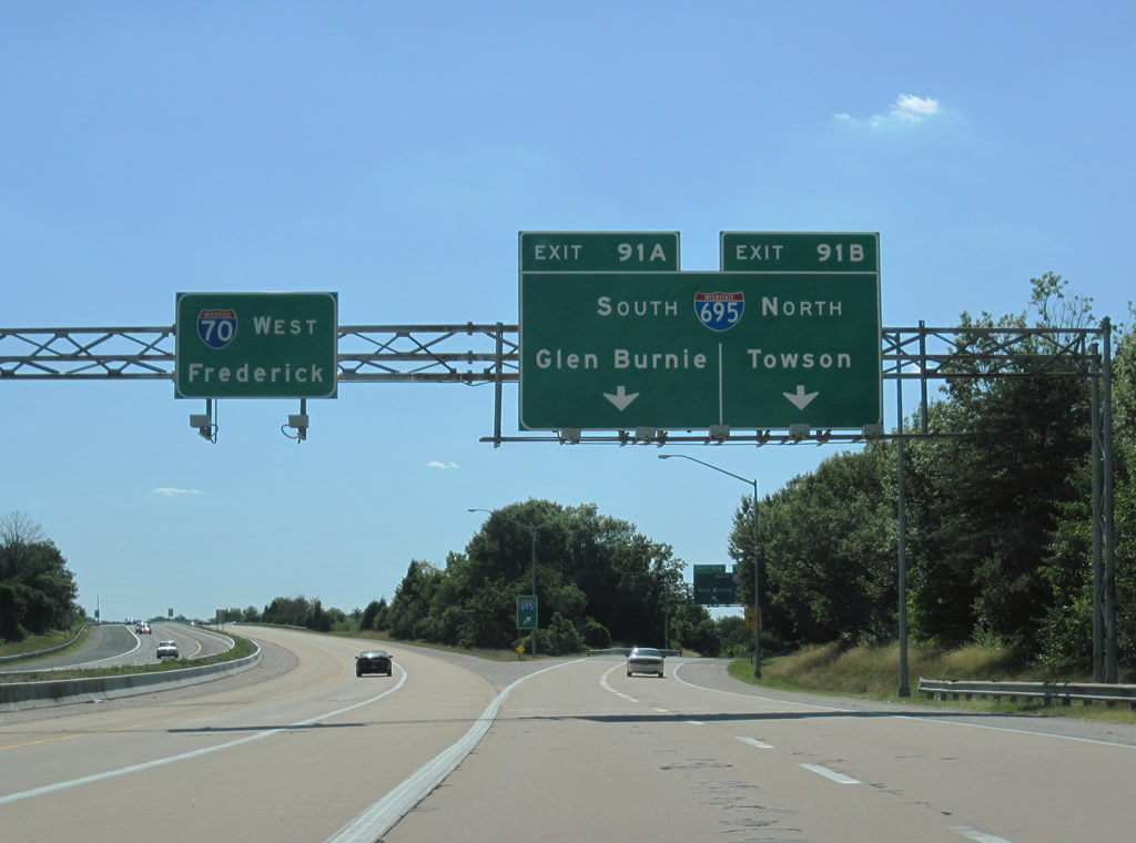
| Two of the three westbound lanes for Interstate 70 default onto the Exit 91 off-ramp to Interstate 695. The majority of commuters utilizing the Park & Ride facility and Security Boulevard interchange return to the Baltimore Beltway instead of taking the semi-rural trek of Interstate 70 west to Howard County. 07/02/10 |
|
| A look at the original set of signs posted on the half mile approach to Exit 91 from Interstate 70 west. The overheads on this sign bridge featured button copy text. Imprints in the sign were visible for three arrows for the westbound lanes; these arrows were removed when Interstate 70 was reduced to one through lane over the Interstate 695 stack interchange. 06/17/00 |
|
| The left lanes consolidate into one lane for through traffic on westbound Interstate 70 to Frederick, while the two right lanes exit onto Interstate 695. The beltway inner loop heads north toward Interstate 795, Pikesville, Towson, and Interstate 83 to Harrisburg, Pennsylvania; the outer loop ventures southeast toward Interstate 95 to Washington, the Baltimore-Washington International Airport, and Interstate 97 to Glen Burnie and Annapolis. 07/02/10 |
|
| Taking the Exit 91 off-ramp to its split into north and southbound components. Interstate 695 north next meets MD 26 (Liberty Road) at Lochearn and Milford. Travelers continuing onto the beltway south come across U.S. 40 (Naitonal Pike) at Westview and Catonsville. 07/02/10 |
|
| A symmetrical stack interchange with high speed connectors for all directions of travel, Exit 91 was designed to carry significantly more traffic on the connector ramps to and from Interstate 70 east of Interstate 695. 07/02/10 |
|
| Interstate 70 continues west from the one lane over crossing above Interstate 695 and merges with traffic from the beltway. What was a relatively quiet ride between the Park and Ride and Interstate 695 changes dramatically after Exit 91 with the addition of commuters and trans-continental traffic alike.
While Interstate 70 continues three miles east of Interstate 695 (Baltimore Beltway) to the Baltimore city line, the first westbound reassurance shield resides just west of Exit 91. Many many more are to come on the drive west to Cove Fort, Utah. 06/08/12 |
|
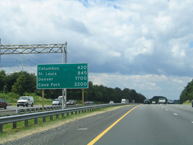
| Posted in Baltimore County, Maryland between June and August of 2004, this distance sign lists major cross country destinations along Interstate 70 and its western terminus at Cove Fort, Utah.
A new distance sign was installed by August 23, 2010 and affixed to the back side of the new overhead assembly over I-70 east. 08/07/04, 06/08/12 |
|
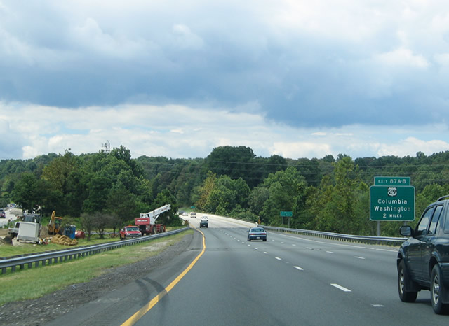
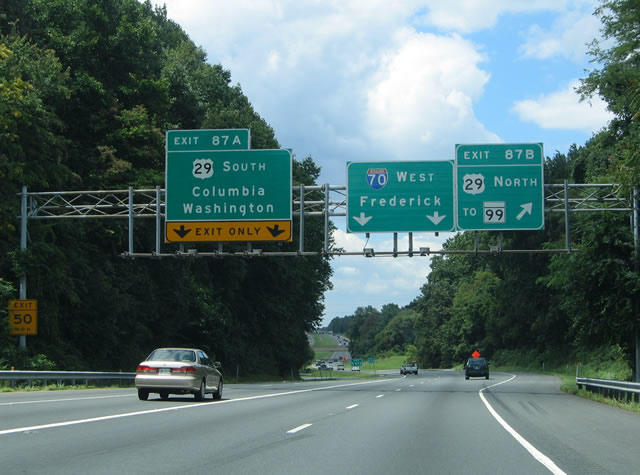
| The next exit along westbound beyond the beltway is Exits 87A-B for U.S. 29 north to MD 99 (Old Frederick Road) and south to Columbia and Washington, D.C. A non-reflective button copy sign for U.S. 29 remained in use until 2005. 08/07/04 |
|
| The next exit along westbound beyond the beltway is Exits 87A-B for U.S. 29 north to MD 99 (Old Frederick Road) and south to Columbia and Washington, D.C. A non-reflective button copy sign for U.S. 29 remained in use until 2005. Photo taken 08/07/04. 06/08/12 |
|
| Interstate 70 westbound at the Patapsco River crossing into Howard County. The freeway also travels through Patapsco Valley State Park north of Chestnut Hill. 06/08/12 |
|
| One mile sign bridge for the directional cloverleaf interchange (Exits 87A/B) with U.S. 29 (Columbia Pike) on Interstate 70 westbound. The northern terminus of U.S. 29 is located nearby at Mt. Hebron. U.S. 29 originally extended east into Baltimore to Pratt / Lombard Streets and U.S. 1 (Fulton Avenue / Monroe Street). 06/08/12 |
|
| U.S. 29 reaches its northern terminus only a half mile north of here, at the point where it meets Old Frederick Road (MD 99). South through Columbia and past MD 100 and MD 32, U.S. 29 is a freeway. South of the District of Columbia, U.S. 29 is a major route into the Deep South, serving the cities of Charlottesville, Charlotte, Greenville, Atlanta, Auburn, and ultimately Pensacola. Rogers Avenue crosses over I-70 ahead of Exit 87 to become MD 99 (Old Frederick Road) at Mt. Hebron and U.S. 29. 06/08/12 |
|
| Simultaneous ramps depart from I-70 westbound for northbound U.S. 29 to MD 99 / Old Frederick Road the U.S. 29 freeway south to the master planned community of Columbia. Columbia was built from scratch using an urban planning concept based upon a pedestrian city. While it was considered innovative at its time during the 1970s, the surrounding areas grew with more typical suburban development. 08/07/04 |
|
| A new sign bridge and carbon copied overheads were installed by 2008 at the ramp departures of Exits 87A/B. Exit 87A merges onto the left side of U.S. 29 (Columbia Pike) ahead of its interchange with U.S. 40 (Baltimore National Pike) west of Ellicott City. 06/08/12 |
|
| After the U.S. 29 interchange, Interstate 70 leaves much of the suburban feel of the highway behind and approaches Exit 83, Marriottsville Road. Frederick is 30 miles further. 06/08/12 |
|
| Marriottsville Road leads south from Exit 83 to reach MD 144 (Frederick Road), which follows the old alignment of U.S. 40 west to Frederick. 06/08/12 |
|
| Westbound Interstate 70 at the Exit 83 half diamond interchange with Marriottsville Road. After Exit 83, Interstate 70's long-distance companion, U.S. 40, meets up with Interstate 70 at Exit 82. Exit 82 is a wye interchange; motorists needing access to U.S. 40 (Baltimore National Pike) east should use Marriottsville Road south. Once U.S. 40 merges onto westbound Interstate 70, the freeway again features six lanes. 06/01/04 |
|
| Sign replacement for the Exit 83 off-ramp of Interstate 70 west. Marriottsville Road arcs northeast to Marriottsville at Patapsco Valley State Park and into Baltimore County, continuing all the way to MD 26 (Liberty Road) near Randallstown. 06/08/12 |
|
| The next exit along westbound Interstate 70 and now cosigned U.S. 40 is MD 32 (Sykesville Road). Deceptively rural through here, MD 32 south becomes a freeway at Clarksville, then angles southeast past Columbia, Annapolis Junction, and Odenton to meet Interstate 97 at Millersville. As yet, the MD 32 freeway has not yet been extended to Interstate 70. 06/08/12 |
|
| Westbound I-70/U.S. 40 at Exit 80 for MD 32 southeast to Clarksville and north to Sykesville. MD 32 continues north to Westminster, where it meets MD 97 and MD 140. 06/08/12 |
|
| A weigh/inspection station is located midway between Exits 80 and 76 along westbound. 06/08/12 |
|
| Most state-named Interstate shields in Maryland have disappeared over the years and very few still remain. This particular assembly near West Friendship was replaced by 2008. 08/07/04, 06/08/12 |
|
| Passing by the truck scales along Interstate 70 west. 06/08/12 |
|
| The next exit links I-70 west with MD 97 (Hoods Mill Road). MD 97 heads north to Westminster, where it meets MD 140, then continues along the former path of U.S. 140 en route to Gettysburg, Pennsylvania. Looking south, MD 97 follows a straight path toward Montgomery County and the Washington, D.C. metropolitan area. 08/07/04 |
|
| A sign replacement of the one mile panel for MD 97 eliminates the center exit tab, but does not feature the now-Maryland standard Clearview font. 06/08/12 |
|
| Nearing the Exit 76 diamond interchange with MD 97 (Hoods Mill Road) at Cooksville. MD 97 becomes PA 97 on the northward drive to Gettysburg, Pennsylvania. Southward the state highway becomes Georgia Avenue at the Montgomery County line en route to Brookeville and Olney. 06/01/04, 06/08/12 |
|
| Westbound I-70/U.S. 40 at the Exit 76 off-ramp to MD 97 to Westminster and Olney. MD 97 travels 55.27 miles overall from U.S. 29 in Silver Spring to the Pennsylvania state line.
Damage to the sign panel, sometime between 2009 and 2008, resulted in the replacement of the MD-97 shield. 06/08/12 |
|
| The succeeding exit along westbound I-70/U.S. 40 is located two miles ahead with MD 94. Frederick is just 20 miles further. 06/08/12 |
|
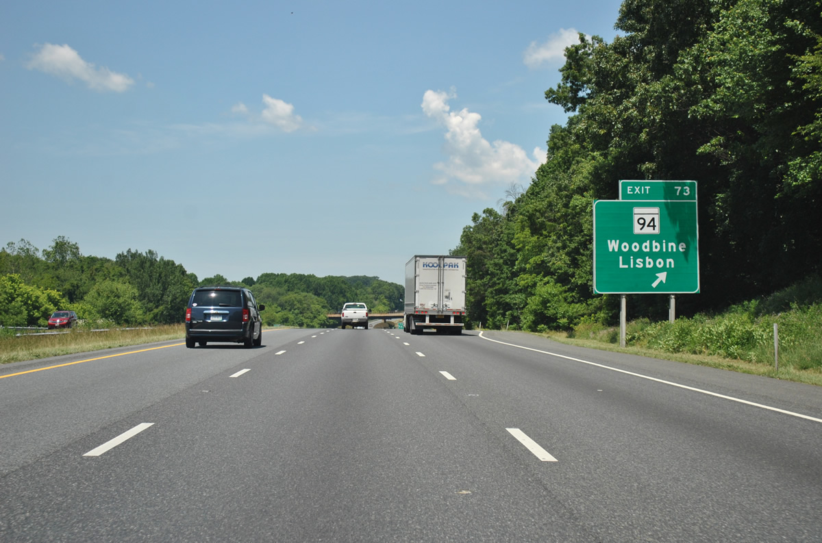
| The next exit along westbound I-70/U.S. 40 is Exit 73, MD 94, two miles. Frederick is just 20 miles further. 06/08/12 |
|
| MD 94 heads south to Lisbon and north toward Woodbine. The state highway travels just 6.3 miles between its endpoints. 06/08/12 |
|
| Nearing the diamond interchange (Exit 73) with MD 94 (Woodbine Road) on I-70 west. Woodbine Road navigates through roundabouts both north and south of Interstate 70. MD 144 (Frederick Road) intersects MD 94 at Lisbon and Old Frederick Road meets Woodbine Road between I-70/U.S. 40 and the Carroll County line. 06/08/12 |
|
| I-70/U.S. 40 westbound at Exit 73 (MD 94). MD 94 sees its northern terminus at the Old Frederick Road roundabout near Woodbine. Southward the state highway follows Woodbine Road to Florence and Annapolis Rock. MD 94 ends at the Patuxent River crossing and Montgomery County line within Patuxent River State Park. 08/07/04, 06/08/12 |
|
| What was the second in a series of Interstate 70 Maryland & U.S. 40 westbound reassurance shields, posted after the Exit 73 on-ramp near Poplar Springs. 08/07/04, 12/30/08 |
|
| Another typical distance sign (and its replacement) posted along a Maryland Interstate highway. Posted here are distances for MD 27 (Exit 68) and the city of Frederick. 08/07/04, 06/08/12 |
|
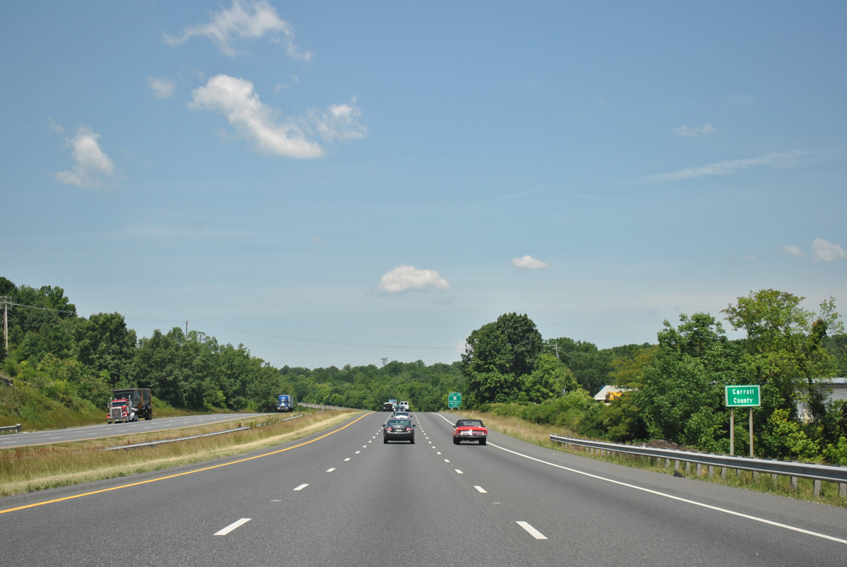
| Exiting Howard County for a short jaunt across the southwestern tip of Carroll County. 06/08/12 |
Page Updated 11-11-2012.

 West
West


 West
West