|
| Crossing into Ohio County, West Virginia along Interstate 70 westbound near West Alexander, Pennsylvania. 10/15/04 |
|
| The first interchange within the Mountain State joins Interstate 70 with County Route 41 (Dallas Pike) at Exit 11. Dallas Pike travels seven miles northwest from Dallas near the Pennsylvania state line to U.S. 40 (National Road). 10/15/04 |
|
| A diamond interchange (Exit 11) joins I-70 with Dallas Pike and the community of Valley Grove in one mile. 10/15/04 |
|
| 0.25 miles ahead of Exit 11 to CR 41 (Dallas Pike) posted on Interstate 70 westbound. Connections from U.S. 40 (National Road) to Dixon Run Road carry travelers northward to WV 88 (Wheeling West Liberty and Bethany Pike) for West Liberty. 10/15/04 |
|
| Interstate 70 westbound at Exit 11 ramp for CR 41 (Dallas Pike). Dallas Pike ends at U.S. 40 (National Road) 1.9 miles to the north. McCutcheon Buckhannon Road stems west from the interchange along the eastbound lanes of Interstate 70. 10/15/04 |
|
| The succeeding exit along I-70 west connects with CR 65 (Cabella Road) near Triadelphia. 10/15/04 |
|
| Interstate 70 West Virginia reassurance shield found along westbound adjacent to Cruzer Road. The Mountain State places both state-named and neutered shields throughout its Interstate system. 10/15/04 |
|
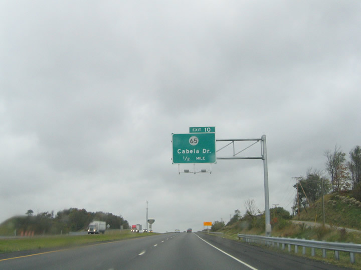
| One half mile east of Exit 10 to CR 65 (Cabella Road) on Interstate 70 west. Cabella Road spurs northwest from the freeway to U.S. 40 (National Road) just east of Triadelphia. 10/15/04 |
|
| Westbound at the Exit 10. The interchange serves the August 2004 opened Cabela's Outlet Mall and wildlife museum nearby. Cabella Road meets U.S. 40 (National Road) to the northwest. 10/15/04 |
|
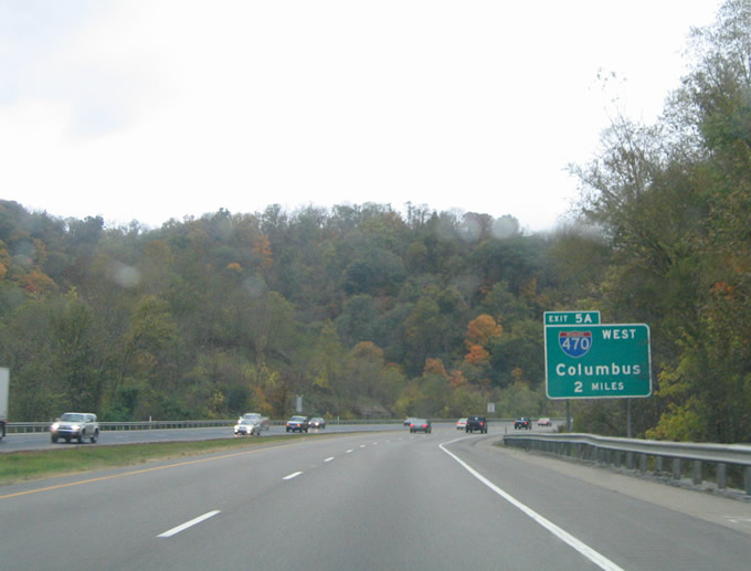
| Interstate 70 curves westward to Triadelphia two miles ahead of the split with Interstate 470 (Exit 5A) at east Wheeling. Interstate 470 comprises the Wheeling Bypass and the preferred through route for traffic bound for Columbus, Ohio. All vehicles carrying hazardous materials must use Interstate 470 west to Ohio in lieu of the Interstate 70 Wheeling Tunnel. 10/15/04 |
|
| Diagrammatic overhead posted 1.50 miles east of the I-70/I-470 split at Wheeling. Interstate 470 travels south of Downtown through Bethlehem and south Wheeling to the Ohio River. The freeway returns to I-70 ten miles to the west near Blaine, Ohio. 10/15/04 |
|
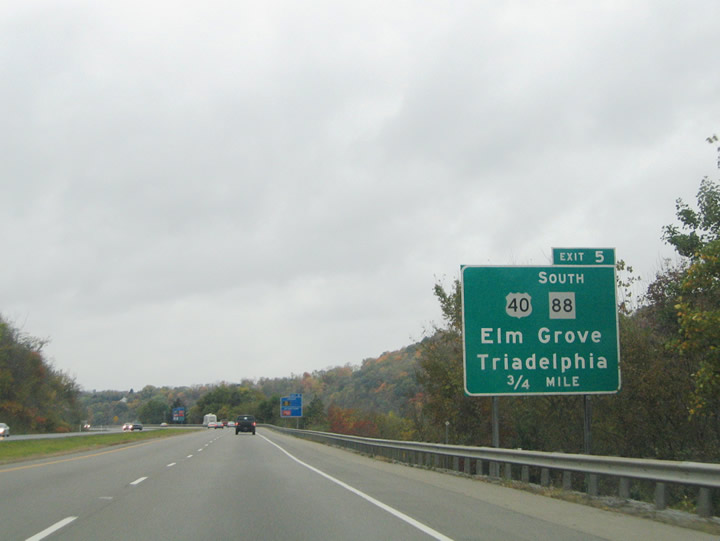
| U.S. 40 (National Road) interchanges with Interstate 70 at Triadelphia and Elm Grove just east of the Interstate 470 split. U.S. 40 enters the scene from Triadelphia to meet WV 88 (Idabelle Avenue) southwest of the Exit 5 folded diamond interchange. From there U.S. 40 & WV 88 overlap 3.3 miles northwest to Edgewood in north Wheeling. 10/15/04 |
|
| Interstate 70 westbound near the Exit 5 ramp departure for U.S. 40 (National Road) at Elm Grove and Triadelphia. U.S. 40 merges with WV 88 nearby at Kruger Street and Idabelle Avenue. WV 88 travels southward from there to Bethlehem, and northern Marshall County. 10/15/04 |
|
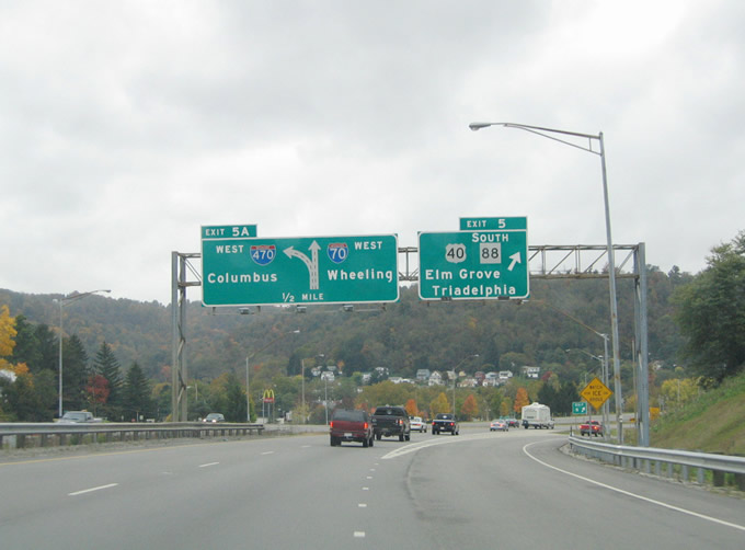
| Traffic to U.S. 40 (National Road) & WV 88 (Idabelle Avenue) departs Interstate 70 westbound at Exit 5. U.S. 40 & WV 88 continue northwest from their merge at Elm Grove to Edgewood in north Wheeling. From there WV 88 follows Bethany Pike north to Greggsville. U.S. 40 continues west along the National Road to Glenwood and downtown Wheeling. 10/15/04 |
|
| A wye interchange connects Interstate 70 west with I-470 west at Exit 5A. I-470 beelines for Bethlehem and Ohio while I-70 continues northwest toward Downtown Wheeling and the Wheeling Tunnel. The freeway crosses the Ohio River at Wheeling Island into Bridgeport, Ohio. 10/15/04 |
|
| The westbound beginning of Interstate 470 leaves Interstate 70 west at Exit 5A. Interstate 470 sees two interchanges in West Virginia before crossing the Ohio River. Exit 2 serves the community of Bethlehem in one mile and Exit 1 joins the freeway with U.S. 250 & WV 2 in south Wheeling. 10/15/04 |
|
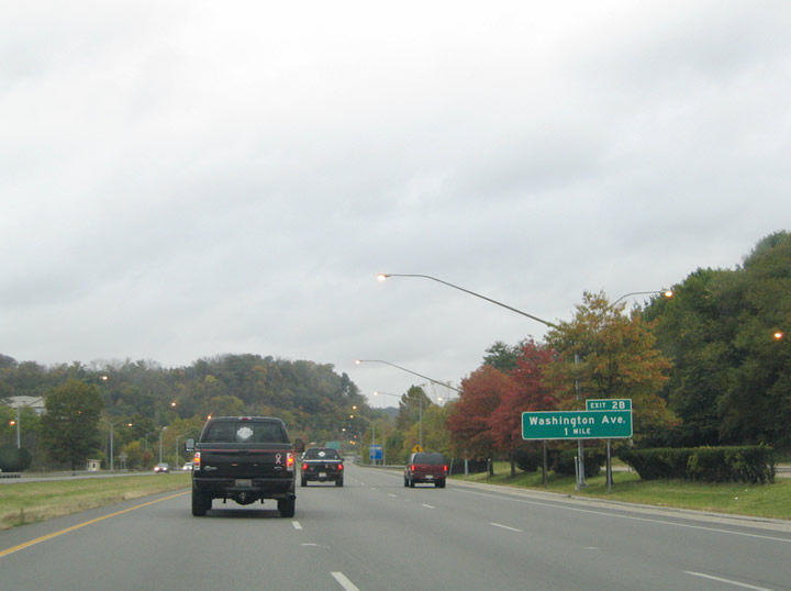
| Continuing northwest along Interstate 70 toward the Exit 2B diamond interchange with Washington Avenue. A rest area lies along the drive between Interstate 470 (Exit 5A) and Washington Avenue. The freeway crosses the Wheeling Creek nearby. 10/15/04 |
|
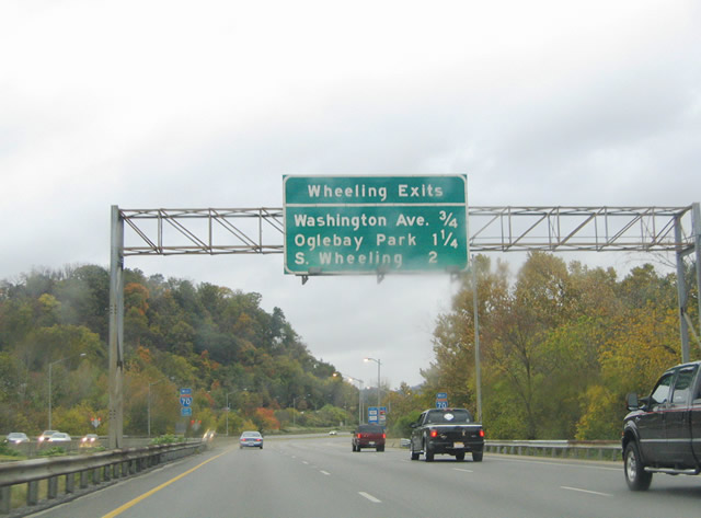
| Button copy overhead featuring the Wheeling exits of Interstate 70 west between east Wheeling and downtown. Washington Avenue (Exit 2B), Oglebay Park (Exit 2A), and U.S. 250 & WV 2 (Exit 1B) lie ahead. 10/15/04 |
|
| 0.25 mile sign bridge for the Exit 2B interchange with Washington Avenue posted on Interstate 70 west. Washington Avenue spans the Wheeling Creek between U.S. 40 & WV 88 (National Road) and Valleview Avenue to the east. The surface street meets Interstate 70 at Armory Drive. 10/15/04 |
|
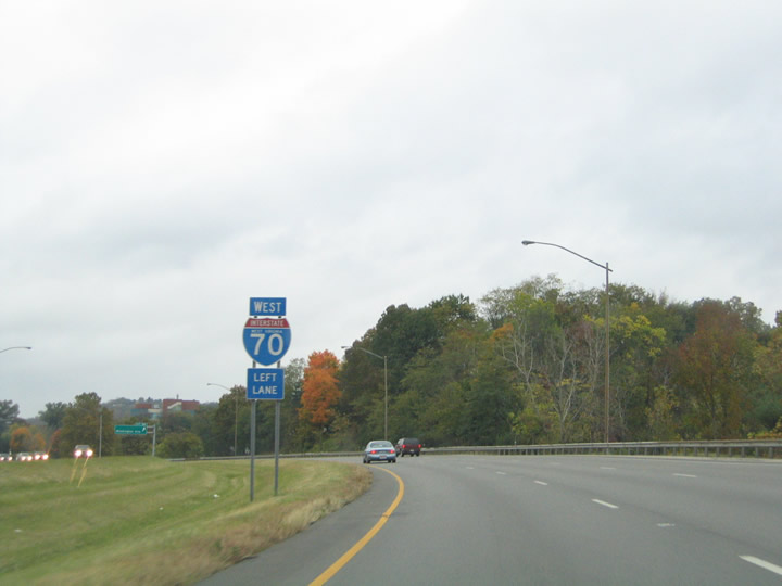
| Through traffic interests along Interstate 70 are advised to move into the left-lane for the upcoming Wheeling Tunnel. The tunnel relegates the mainline to just one through lane briefly between Exits 1B and 1A. 10/15/04 |
|
| Exit 2B departs Interstate 70 westbound for Washington Avenue. Washington Avenue becomes Armory Drive upon crossing the freeway. Mt. de Chantel Road intersects Armory Road to the south and parallels Interstate 70 from Wheeling Hospital northward to Rock Point Road and Oglebay Park. 10/15/04 |
|
| Continuing westbound on Interstate 70 toward Downtown Wheeling. Attached to the Armory Drive overpass is an interchange sequence sign listing the next three city interchanges (Exits 2A, 1B and 1A). 10/15/04 |
|
| Exit 2A lowers from I-70 west onto adjacent Mt. de Chantel Road at Oglebay Park. Mt. de Chantel Road intersects U.S. 40 (National Road nearby. U.S. 40 (National Road) east links with WV 88 (Bethany Pike) at Woodsdale. The state route departs U.S. 40 from there on a 3.4 mile drive to Oglebay Park. 10/15/04 |
|
| A wye interchange joins Interstate 70 eastbound directly with U.S. 40 (National Road) just west of the Mt. de Chantel Road off-ramp. Placed above the eastbound off-ramp is another interchange sequence sign listing the final three West Virginia interchanges situated between Exit 2B and the Ohio state line. 10/15/04 |
|
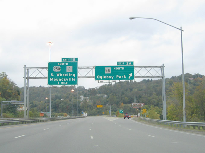
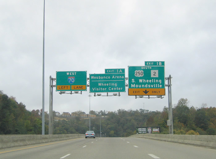
| Interstate 70 elevates over the Wheeling Creek and a nearby railroad line between Exit 2A and U.S. 250 & WV 2 (Exit 1B). U.S. 250 & WV 2 northbound merge onto Interstate 70 west to Downtown Wheeling. The tandem follow a five mile freeway between Exit 1B and Moundsville to the south. Exit 1A serves the Wheeling Visitor Center and Wesbanco Arena in Downtown. 10/15/04 |
|
| Nearing the Wheeling Tunnel on Interstate 70 westbound at the Exit 1B off-ramp to U.S. 250 & WV 2 south. An "X" stack interchange joins the two freeways just northeast of downtown Wheeling. U.S. 250 & WV 2 merge onto Interstate 70 west through the tunnel ahead. Upon exiting the tubes WV 2 splits from Interstate 70 west & U.S. 250 north via Exit 1A for Market Street north. 10/15/04 |
|
| Interstate 70 through traffic must move into the left-lane through the Wheeling Tunnel. The right lane becomes an exit-only affair for Exit 1A onto U.S. 40 east & WV 2 north (Market Street) and Main Street south into downtown. 10/15/04 |
|
| Speed limits lower to 45 mph as Interstate 70 west & U.S. 250-WV 2 north enter the Wheeling Tunnel. Downtown Wheeling lies just west of the mountain ahead. 10/15/04 |
|
| Entering the Wheeling Tunnel along Interstate 70 westbound. Lane changes are prohibited so traffic for Exit 1A should already be in place before entering the tube. The Wheeling Tunnel opened in the early 1960s. 10/15/04 |
|
| Interior views of the Wheeling Tunnel showing the two lane westbound tube. 10/15/04 |
|
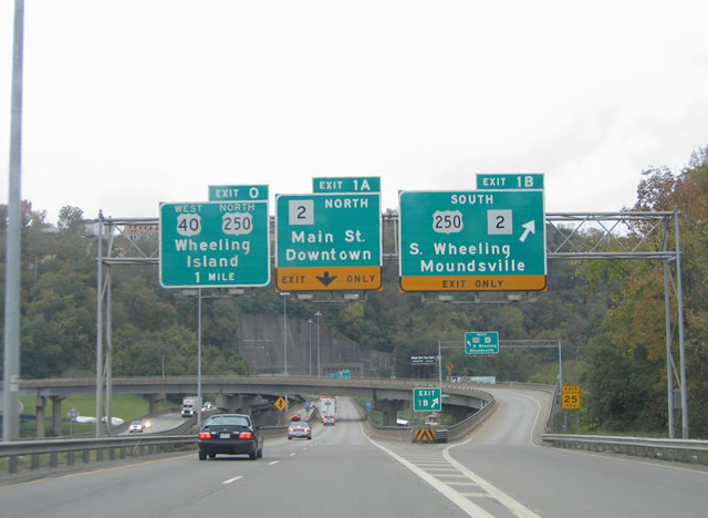
| Interstate 70 west & U.S. 250 north emerge from the Wheeling Tunnel at downtown Wheeling. Exit 1A quickly departs for Market Street north & Main Street south. WV 2 northbound joins U.S. 40 east along Market Street between Interstate 70 and 7th Street. There WV 2 northbound merges with southbound along Main Street for the drive out of Wheeling. WV 2 straddles the Ohio River east banks from Wheeling northward to Weirton. 10/15/04 |
|
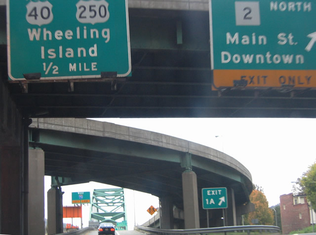
| Interstate 70 west & U.S. 250 north continue through the interchange at Exit 1A onto the Ohio River bridge. An overhead advises motorists to use the left lane for the continuation of Interstate 70 west into Ohio. However only one lane is allocated for drivers between the Wheeling Tunnel and on-ramp from Market Street north. 10/15/04 |
|
| Ramps converge and join Interstate 70 west & U.S. 250 north from the one way street couplet of Main & Market Streets. U.S. 40 westbound joins the freeway between downtown and Wheeling Island (Exit 0). 10/15/04 |
|
| The speed limit remains at 45 mph for I-70/U.S. 40-250 as they cross the Ohio River between downtown Wheeling and Wheeling Island. Exit 0 serves the Wheeling Island Racetrack and Gaming Center at the south end of the island. 10/15/04 |
|
| A green painted steel-arch bridge spans the Ohio River between Exits 1A and 0 along Interstate 70 west. Ahead is the departure of U.S. 40 west & U.S. 250 north for Zane Street at Exit 0. Zane Streets carry the US highway pair from Wheeling Island to Bridgeport, Ohio. There U.S. 250 turns northwest along Cadiz Pike Road to Harrisville and Cadiz. 10/15/04 |
|
| Westbound at the wye interchange with Zane Street on Wheeling Island. U.S. 40 west & U.S. 250 north leave the freeway for a 0.4 mile link to SR 7 (Lincoln Avenue) in Bridgeport. U.S. 40 resumes along the National Road from Bridgeport west to Brookside, Wolfhurst, Lansing and Blaine, Ohio. 10/15/04 |
|
| Interstate 70 remains elevated to cross the west branch of the Ohio River between Wheeling Island and Bridgeport. Exit 225 departs the freeway for SR 7 (Lincoln Avenue) in one half mile at the Marion Street diamond interchange. Traffic to SR 7 must take Marion Street north to U.S. 40 (National Road) east for its intersection with Lincoln Avenue. 10/15/04 |
|
| Milepost 0 lies along Interstate 70 westbound over the west banks of the Ohio River. A U.S. 40 shield attached to the following light posts indicates the connection between Exit 225 and Marion Street with the adjacent National Road. SR 7 meanwhile straddles the Ohio River between East Liverpool and Chesapeake. 10/15/04 |
Page Updated 03-07-2005.

 West
West