|
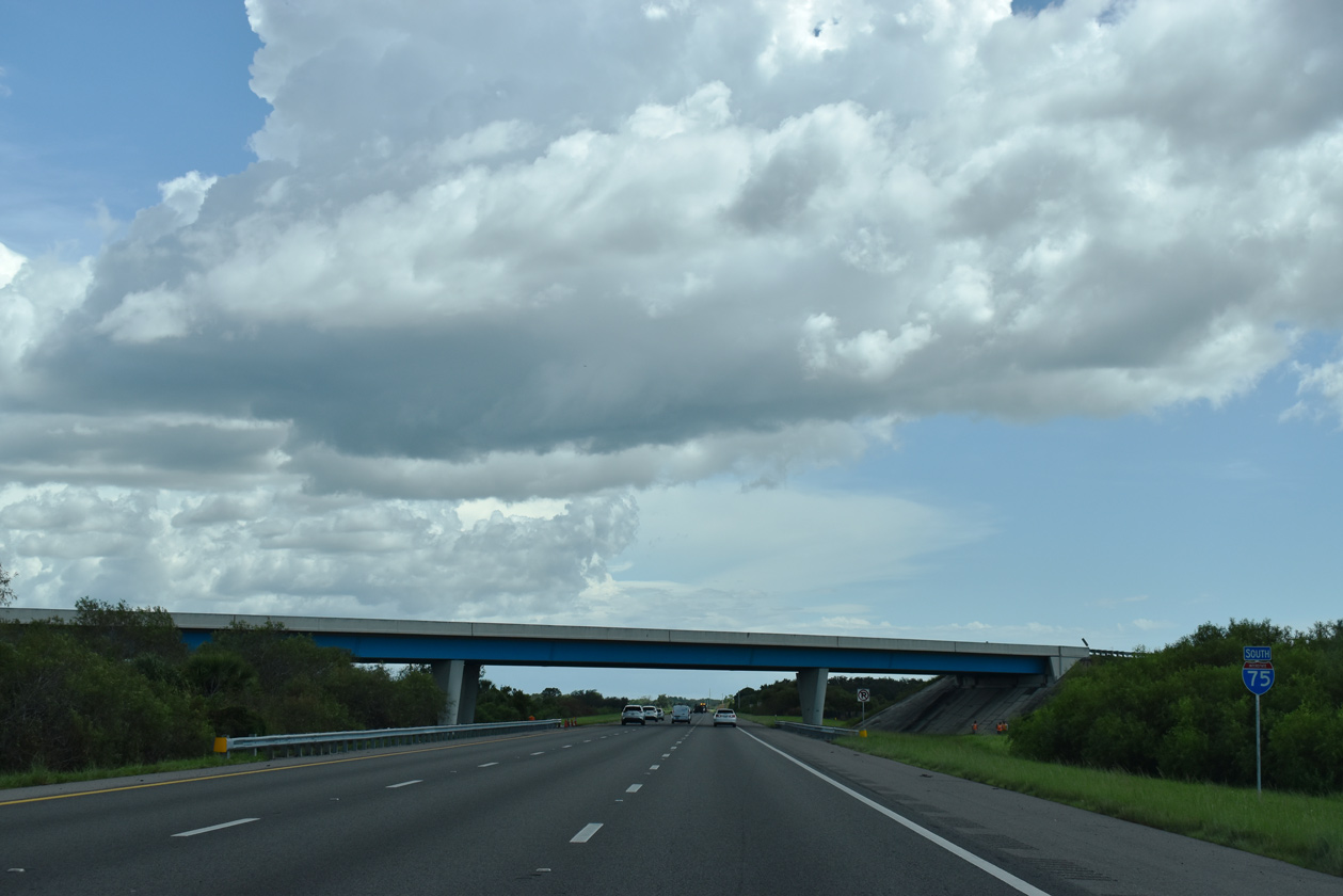
| The $74.1 million DDI project at University Parkway included the addition of an auxiliary lane in each direction of Interstate 75 between Exits 213 and 210.1 08/28/18 |
|
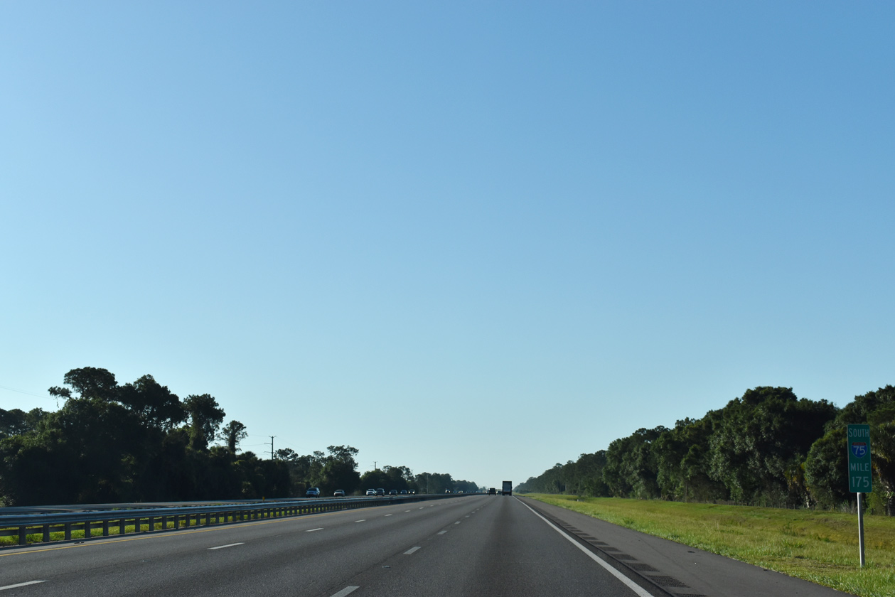
| I-75 runs alongside Cooper Creek Lake and Nathan Benderson Park to the west and progresses 1.75 miles toward Exit 210 for SR 780. Located within the central part of Sarasota County, the city center of Venice is 23 miles ahead. 05/18/19 |
|
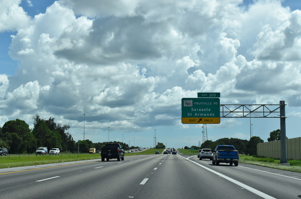
| A community interchanges identification sign outlines the succeeding three exits with state roads that each serve area Gulf of Mexico beaches. Also serving Sarasota, SR 780 leads west to Lido Key and St. Armands. SR 758 and SR 72 formerly extended west across the Intracoastal Waterway to Siesta Key. 06/11/21 |
|
| The six-ramp parclo interchange at Exit 210 with SR 780 (Fruitville Road) will be reconstructed into a DDI as part of a two mile widening project along I-75 between a point north of Fruitville Road south to Palmer Boulevard. Estimated to cost $86 million, construction is unfunded, and design work runs through late 2021 early 2026.2 08/28/18 |
|
| SR 780 follows Fruitville Road west from Exit 210 to U.S. 301 near the Sarasota Historic District. Unsigned CR 780 extends 23.36 miles east from I-75 at Fruitville to Old Myakka and Sandy. 08/28/18 |
|
| Heavily developed west of Exit 210, SR 780 passes by Robarts Arena en route to Downtown Sarasota. The arena is home to the annual county fair as well as other events. Fruitville Road continues west from U.S. 301. 0.9 miles to U.S. 41 (Tamiami Trail) near Sarasota Bay. U.S. 41 south to SR 789 (John Ringling Causeway) leads to St. Armands. 08/28/18 |
|
| SR 780 (Fruitville Road) measures 5.64 miles in length between U.S. 301 and Coburn Road. Growth from the late 1990s to early 2000s west of Exit 210 turned SR 780 (Fruitville Road) from a two lane route to a six lane arterial. 05/18/19 |
|
| Industrial parks lines both sides of Interstate 75 south from SR 780 to Phillippi Creek. 08/28/18 |
|
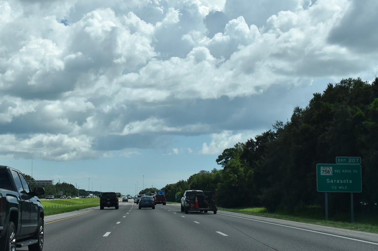
| A parclo interchange (Exit 207) connects I-75 with Bee Ridge Road (SR 758) in two miles. Venice is another 18 miles away followed by Naples in 109 miles. 08/28/18 |
|
| SR 758 (Bee Ridge Road) is another heavily traveled arterial linking I-75 with Sarasota. State maintenance along Bee Ridge Road ends just east of Exit 207 across Phillippe Creek. 08/28/18 |
|
| Widening planned for a 3.8 mile segment of I-75 between SR 780 (Fruitville Road) and a point south of SR 758 includes rebuilding Exit 207 at Bee Ridge Road into a hybrid diverging diamond interchange (DDI) with a southbound diversion ramp. A continuous flow intersection (CFI) will be constructed to the immediate west along SR 758 at Cattlemen Road.3 08/28/18 |
|
| SR 758 (Bee Ridge Road) provides an indirect connection with the northern end of Siesta Key, via Osprey Avenue north and Siesta Drive west. Both of these roads were formerly a part of SR 758 until May 2018 when FDOT swapped mileage with Sarasota County for CR 777 on River Road.4
Located south of Downtown Sarasota, the Marie Selby Botanical Gardens line U.S. 41 (Tamiami Trail) north of Bee Ridge Road. Covering nearly 14 acres, the gardens take in over 130,000 visitors each year.5 08/28/18 |
|
| The last of four exits for the Sarasota area along Interstate 75 links with SR 72 (Clark Road) in one mile. 08/28/18 |
|
| Proctor Road (former CR 72A) spans Interstate 75 beyond this southbound confirming marker. 08/28/18 |
|
| 41.14 miles in length, SR 72 extends west to U.S. 41 ahead of Siesta Key and travels east through Myakka River State Park to SR 70 just outside of Arcadia. 08/28/18 |
|
| Costing $62.4 million, construction underway from late 2021 to late 2023 converts the diamond interchange at Exit 205 into a DDI and adds auxiliary lanes southward from Proctor Road.6 08/28/18 |
|
| SR 72 (Clark Road) transitions into a rural highway beyond Sarasota National Cemetery east en route to Myakka River State Park. 06/11/21 |
|
| SR 72 (Clark Road) constitutes a six lane commercial arterial west to U.S. 41 at Stickney Point Road. Stickney Point Road was formerly part of SR 72 west onto Siesta Key until 2018. 06/11/21 |
|
| Suburban development continues along the west side of Interstate 75 along parallel Honore Avenue south from the Sarasota area. 08/28/18 |
|
| The succeeding exit along I-75 south is with SR 681, the Venice Connector in four miles. Located along U.S. 41 (Tamiami Trail), the incorporated city of North Port succeeds Venice along I-75 in another 20 miles. 08/28/18 |
|
| A second reassurance marker for Interstate 75 stands along southbound by mile marker 201.5 08/28/18 |
|
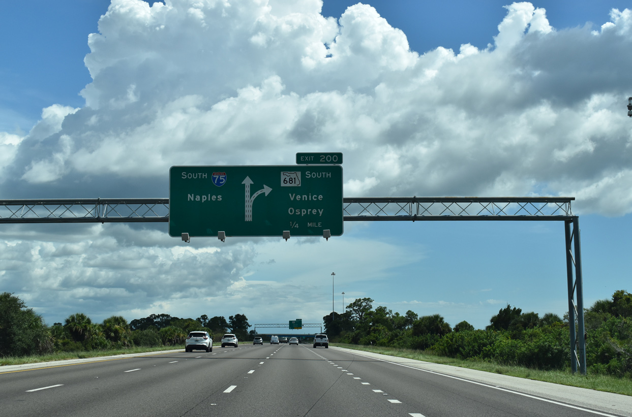
| SR 681 branches southwest from I-75 at a wye interchange (Exit 200) in one mile. The Venice Connector is a 4.14 mile long spur linking Interstate 75 with U.S. 41 between Osprey and Laurel. 08/28/18 |
|
| The city of Venice lies seven miles to the south from Exit 200 via U.S. 41. Oscar Sherer State Park is located 1.5 miles to the north of SR 681 along U.S. 41. 08/28/18 |
|
| Past plans outlined repurposing the Venice Connector as a super arterial with at least three at-grade intersections for future residential and commercial development. Intersections were eventually added, including a signalized one with the extension of Honore Avenue south from SR 72. 08/28/18 |
|
| Two lanes depart southbound Interstate 75 at Exit 200 for SR 681 (Venice Connector) south. 08/28/18 |
|
| A reassurance marker stands just beyond the separation with Exit 200. Areas east of the freeway remain rural, but long range plans call for an extension of Lorraine Road southward from Lakewood Ranch. 08/28/18 |
|
| The ensuing exit along I-75 south is with Laurel Road in four miles. Six lane expansion along Interstate 75 between Exit 200 / SR 681 and Exit 191 / River Road was completed by Summer 2012. 08/28/18 |
|
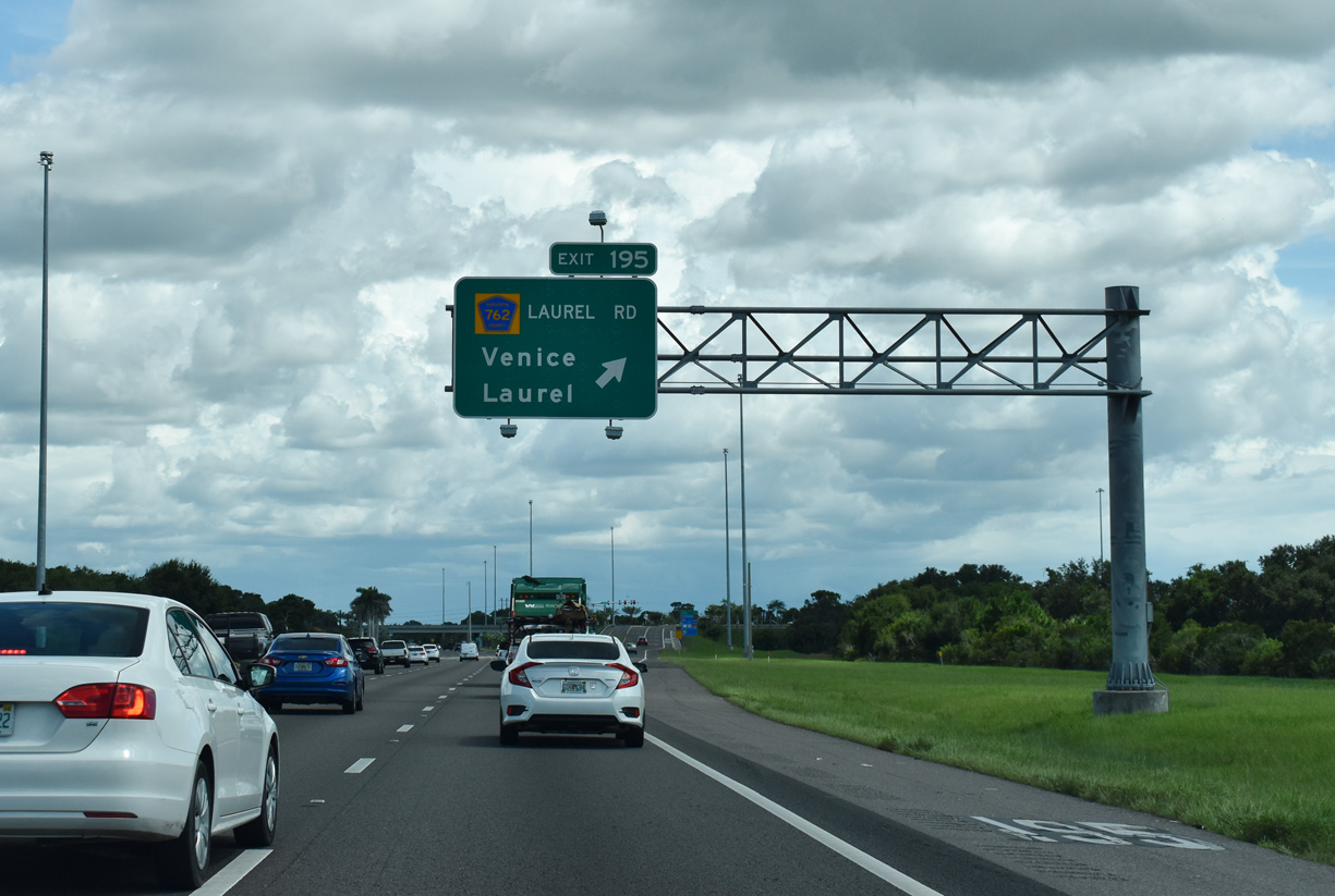
| As part of I-75 widening, a new southbound span over Cow Pen Slough was built, with the roadway shifted inward. The previous southbound roadway was repurposed as part of an extension of Honore Avenue from SR 681 to Laurel Road at Exit 195. 08/28/18 |
|
| Originally, Laurel Road (CR 762) had no direct access to I-75. Construction of the diamond interchange at Exit 195 took place well over a decade after Interstate 75 opened through this area. 08/28/18 |
|
| Laurel Road heads 3.5 miles west from Exit 195 to Bayshore Road near Laurel and Nokomis, and 2.9 miles east to Venice Myakka River along the Myakka River. 08/28/18 |
|
| The roadways of I-75 are separated by nearly 1,000 feet through the exchange (Exit 195) with Laurel Road. I-75 straddles the Venice city line south to Laurel Road, where the it wholly enters the city limits. 11/28/19 |
|
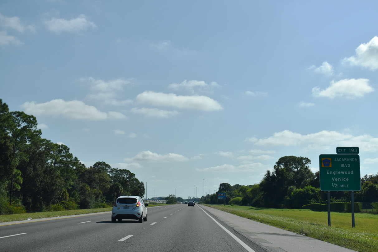
| Jacaranda Boulevard weaves south between newer subdivisions in northeast Venice to meet Interstate 75 at forthcoming Exit 193. 11/28/19 |
|
| Interstate 75 orientates eastward along a 14.8 mile course across central Sarasota County from near Exit 193 to a point after Exit 179. 11/28/19 |
|
| Jacaranda Boulevard (fCR 765) runs 6.04 miles south from Border Road in Venice to U.S. 41 and SR 776 at South Venice. Located along Lemon Bay, the community of Englewood is south of U.S. 41 along SR 776. 11/28/19 |
|
| A parclo interchange joins I-75 with Jacaranda Boulevard (CR 765) at Exit 193. Jacaranda Boulevard south to Venice Avenue (CR 772) west leads into Historic Downtown Venice. 08/28/18 |
|
| River Road arcs 13.49 miles south from Exit 191 to SR 776 (Indiana Avenue) at Englewood via Myakka State Forest. A mileage exchange in 2018 between Sarasota County and FDOT added River Road to the state road system in exchange for sections of SR 758 and SR 72 on Siesta Key.3 08/28/18 |
|
| I-75 crosses Havana Road one half mile west of the diamond interchange (Exit 191) with River Road. 5.82 miles long, River Road is SR 777 from I-75 south to U.S. 41. 08/28/18 |
|
| The previous six lane section of I-75 concluded south at Exit 191. The addition of River Road to the state road system preceded $47.5 million in construction widening SR 7777 from early 2022 to early 2025. South of U.S. 41, CR 777 extends along River Road 7.67 miles into Englewood.
A closed off-freeway rest area lies in the northeast quadrant of this exchange. 08/28/18 |
|
| Interstate 75 spans the Myakka River just east of SR 777 (River Road). The Myakka River meanders from Lower Myakka Lake within Myakka River State Park southeastward and empties into Charlotte Harbor east of El Jobean. 08/28/18 |
|
| An 8.5 mile long section of I-75 from River Road to Sumter Boulevard in North Port was expanded to six overall lanes during a $35.6 million project underway from 2013 to Summer 2016.8 11/28/19 |
|
| Located eight miles ahead, Sumter Boulevard is the first of two exits for the city of North Port. Situated along the north banks of the Peace River across from Punta Gorda in Charlotte County, Port Charlotte lies 22 miles to the southeast. 08/28/18 |
|
| Continuing east, Interstate 75 enters the North Port City limits at Van Camp Waterway. A pervasive network of rural streets spreads both north and south of the freeway along this stretch. 11/28/19 |
|
| North Port is a sprawling municipality that saw tremendous growth until the economic bust of the late 2000s. North Port Charlotte was the official incorporated name, but in 1974 residents approved changing it be simply known as North Port. 08/28/18 |
|
| Sumter Boulevard (CR 771) was sparsely developed between U.S. 41 and I-75 until the late 1990s and early 2000s. Residential growth followed along the arterial during the economic boom of the mid 2000s. 08/28/18 |
|
| Sumter Boulevard (CR 771) heads 4.59 miles south from the diamond interchange at Exit 182 to the commercial center of North Port at U.S. 41. North Port City Hall lies along Sumter Boulevard ahead of W Price Boulevard. 08/28/18 |
|
| Advancing east, Interstate 75 runs between residential across northern North Port. 11/28/19 |
|
| Cape Coral appears on distance signage at 47 miles out. Home to over 200,000 residents per 2021 Census estimates, the Lee County city lies west of Fort Myers and the Caloosahatchee River. 11/28/19 |
|
| Exit 179 is the first of two along southbound I-75 for Port Charlotte. Toledo Blae Boulevard (CR 779) constitutes a 5.42 mile long arterial south to U.S. 41 in Charlotte County. 11/28/19 |
|
| Toledo Blade Boulevard south to SR 776 (El Jobean Road) west leads to Charlotte Sports Park, spring training site for the Tampa Bay Rays MLB team and their minor league affiliate, the Charlotte Stone Crabs. 05/18/19 |
|
| Toledo Blade Boulevard heads 0.98 miles north from Exit 179 to Tropicaire Boulevard. The arterial south crosses U.S. 41 northwest of Murdock and loops east, becoming Cochran Boulevard beyond Collingswood Boulevard. 11/28/19 |
|
| I-75 south enters the diamond interchange (Exit 179) with Toledo Blade Boulevard (CR 779). Initial plans from the 1970s incorporated Toledo Blade Boulevard into an extension of SR 39 south from Hillsborough County. This route designation never came to fruition, most likely due to the state reducing the inventory of state roads in the early 1980s. 11/28/19 |
|
| $73 million expansion of I-75 from four to six lanes took place along the 15.6 mile long segment from Sumter Boulevard to Harborview Boulevard between January 4, 2016 and late 2017.9 08/28/18 |
|
| Turning southeastward, Interstate 75 advances eight miles to Charlotte County. Fort Myers is 42 miles away. 11/28/19 |
|
| Long range plans call for a new interchange along I-75 between mileposts 174 and 173 at Yorkshire Street. Included in the Sarasota County comprehensive plan, freeway access will serve "Activity Center 6". a 1,267 acre area with 199 acres slated for commercial development, 383 for industrial and 133 for offices.10 05/18/19 |
|
| Angling southeast, Interstate 75 leaves the North Port city ahead of Exit 170 for CR 769 (Kings Highway). 05/18/19 |
|
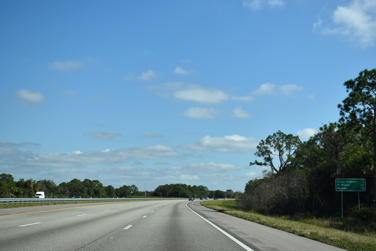
| Interstate 75 nips the southwest corner of DeSoto County at Lake Suzy. Arcadia, the only incorporated city within the county, lies 21.1 miles to the northeast. 05/18/19 |
Page Updated 08-26-2022.

 South
South