Called the "Greatest City in America" on Baltimore's official website, the city was established in 1792 and is also known as the City of Firsts. For instance, in 1816, Baltimore was the first city to illuminate streets with hydrogen gas. A century later, in 1920, Baltimore was home to the first factory to manufacture stainless steel (Rustless Iron & Steel Company). With the history of the War of 1812 and the bountiful waterfront, Baltimore is a renaissance city.
|
| U.S. 40 (Pulaski Highway) passes under I-95 beyond this overhead for the former Baltimore Travel Plaza. A pair of ramps join I-95 south from both U.S. 40 west and Moravia Road south. Exit 59 follows onto Eastern Avenue (MD 150) west to the Canton and Fells Point communities off the Inner Harbor. 08/04/13 |
|
| A Maryland Transportation Authority welcome sign formally marks the transition onto the Fort McHenry Tunnel Approach. 08/04/13 |
|
| Advancing south toward Exit 59 for MD 150, I-95 passes through a wye interchange with Moravia Road. This exchange includes stubs added for the cancelled Winlass Freeway that was intended to link I-95 with I-695 near Chesaco Park. 08/04/13 |
|
| MD 150 follows Eastern Avenue east to Essex and Middle River, culminating in Chase near the mouth of the Gunpowder River. 08/04/13 |
|
| MD 150 (Eastern Avenue) continues west to Ponca Street and Interstate 895. The state route is unsigned westward along Lombard Street and Haven Street to U.S. 40 (Pulaski Highway) near Highlandtown. 08/04/13 |
|
| Southbound Interstate 95 at the parclo interchange (Exit 59) with MD 150 (Eastern Avenue). MD 150 measures 13.07 miles from Baltimore to Chase. 08/04/13 |
|
| Approaching the Eastern Avenue overpass, I-95 southbound next meets O'Donnell Street and connections to Boston Street at Exit 57. 08/04/13 |
|
| Southbound reassurance shield for Interstate 95 posted west of Hudson Heights in Baltimore. 08/04/13 |
|
| I-95 navigates westward through an S-curve between the Greektown and Medford neighborhoods to Exit 57 with O'Donnell Street. 06/20/12 |
|
| The exchange at O'Donnell Street represents the planned end of I-83. I-83 was to be extended southeast from Fayette Street roughly along the Boston Street corridor. Vehement local opposition prevented that connection and instead Boston Street and President Street were widened. 08/04/13 |
|
| Several signs were replaced along Exit 57 in 2012, though they continue to reference the Baltimore Travel Plaza. The former bus terminal closed on January 25, 2011.2 08/04/13 |
|
| Exit 57 combines with Exit 11B from I-895 north and loops underneath I-95 to O'Donnell Street at Interstate Avenue south. 08/04/13 |
|
| Interstate Avenue extends south from Exit 57 and O'Donnell Street by the former Baltimore Travel Plaza and west to become Boston Street after Ponca Street. 08/04/13 |
|
| Interstate Avenue quickly intersects the O'Donnell Street Cutoff west to O'Donnell Street and east to Boston Street and the Broening Highway (unsigned MD 695 south of the city line). 08/04/13 |
|
| Continuing south, Interstate 95 ascends onto a viaduct leading 1.5 miles west to the Fort McHenry Tunnel toll plaza. 06/20/12 |
|
| Exit 56 to Keith Avenue departs in one mile for the Canton Industrial Area and the Port of Baltimore Seagirt and Dundalk Marine Terminals. 06/20/12 |
|
| The first in a series of overhead signs advising motorists of the Fort McHenry toll plaza. An E-ZPass dedicated lane bypasses the barrier to the left. 06/20/12 |
|
| Baltimore Harbor and some of the large container cranes that lift cargo in and out of ships at the port, come into view on the I-95 viaduct a half mile from Exit 56 to Keith Avenue. 06/20/12 |
|
| Tolls to cross the Fort McHenry Tunnel, along with those for the Harbor Tunnel (I-895) and Francis Scott Key Bridge (I-695) increased to $2 per passenger vehicle in 2004. Further increases took place on October 1, 2011 to $3 and on July 1, 2013 to $4. 08/04/13 |
|
| Exit 56 to Keith Avenue represents the last southbound exit before the toll plaza and the final opportunity for vehicles carrying hazardous materials to depart ahead of the Fort McHenry Tunnel. 08/04/13 |
|
| The ensuing exit beyond the Fort McHenry Tunnel leads to historic Fort McHenry, which was the site of one of the most famous battles of the War of 1812 between the United States and the British Empire. Upon seeing the "dawn's early light" after a siege on the fort, American Francis Scott Key wrote the national anthem, proclaiming his pleasure to see that the Americans had won the battle because the "flag was still there." 08/04/13 |
|
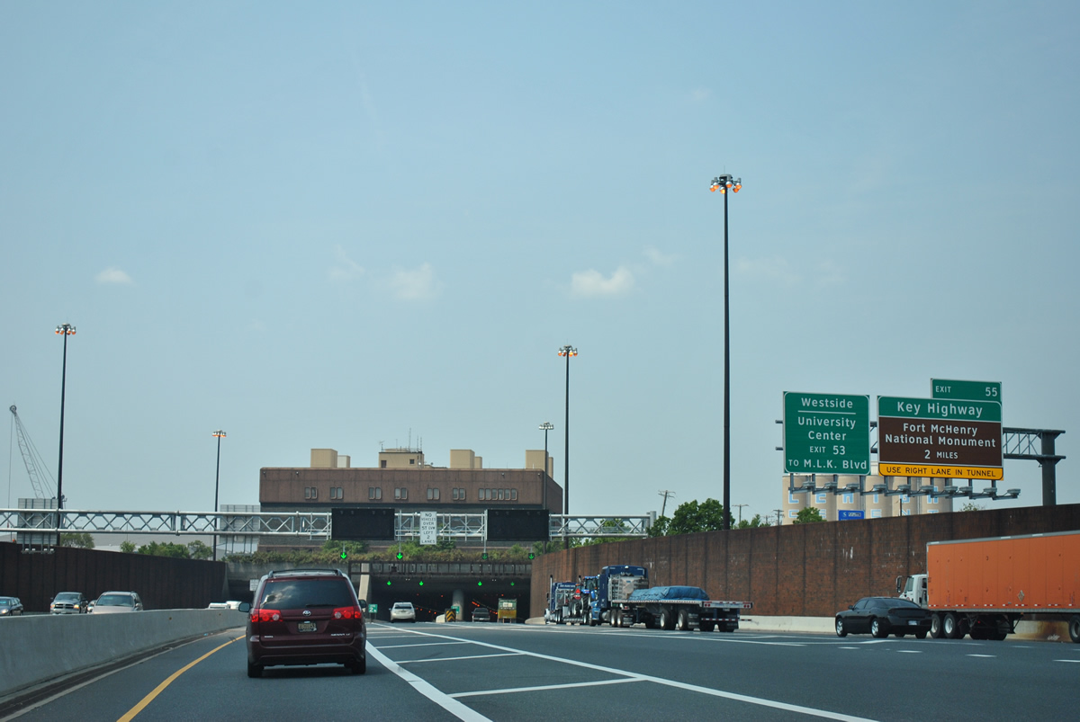
| Entering the toll plaza, traffic partitions into a single E-ZPass bypass lane with a 40 mph speed limit and separate lanes for cash transactions, E-ZPass and truck toll collection. 08/04/13, 06/30/10 |
|
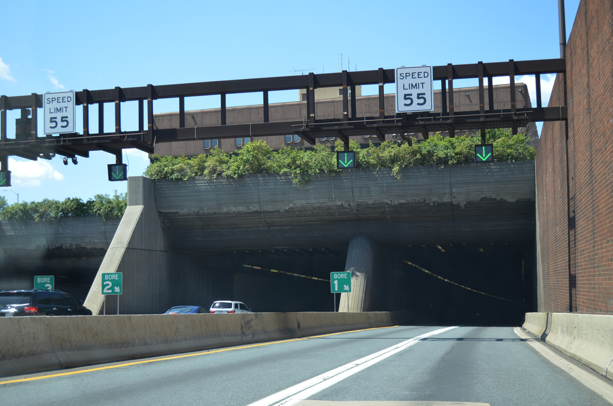
| Exit 55 to Key Highway departs beyond the northern most tube (Bore #1). It is not accessible from the E-ZPass bypass lane. Key Highway also connects to several port areas, including South Locust Point Marine Terminal and Hull Street Pier. 06/20/12 |
|
| The Fort McHenry Tunnel passes under Northwest Harbor just beyond the point at Fort McHenry. Opened to traffic on November 24, 1985, the 1.5 mile long tunnel was constructed as an alternative to a bridge over the harbor to allow for minimal aesthetic impact to the Historic Fort McHenry area. 06/20/12, 08/04/13 |
|
| With eight overall lanes, the Fort McHenry Tunnel, like the Harbor Tunnel (I-895) carries two lanes in each tube. 04/30/04, 06/30/10 |
|
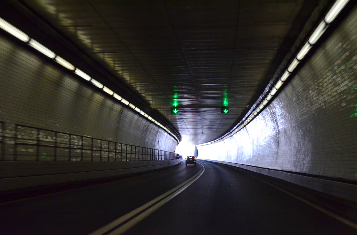
| Traveling through bore #1 of the Fort McHenry Tunnel. 08/04/13 |
|
| Exit 55 separates from I-95 onto McComas Street to Key Highway. Key Highway provides an alternate route north to Downtown, connecting with MD 2 (Light Street) via Riverside and Federal Hill. 06/20/12 |
|
| A directional T interchange (Exit 53) joins I-95 with Interstate 395 north in one mile to Ravens Stadium, Camden Yards, the University of Maryland at Baltimore (UMB), Hopkins Plaza and Baltimore central business district. 08/04/13 |
|
| I-395 is a feeder route with two legs. Connecting with Martin Luther King, Jr. Boulevard, the western branch bypasses Downtown. The eastern leg along Cal Ripken Way ties into S Howard Street at the Baltimore Convention Center and Conway Street west of the Inner Harbor. 08/04/13 |
|
| The systems interchange with I-395 is elevated mostly over the Middle Branch of the Patapsco River. Exit 52 for MD 295 (Baltimore Washington Expressway) south departs from within the exchange with I-395. 08/04/13 |
|
| Exit 53 leaves for I-395 north to the Inner Harbor and Downtown. Exit 52, a long flyover to Baltimore-Washington Expressway south, quickly follows. Trucks are permitted on MD 295 south to MD 175. 08/04/13 |
|
| Gore point sign for Interstate 395 / Exit 53 on I-95 south. The freeway spur was completed on December 9, 1982. 06/30/10 |
|
| Downtown Baltimore spreads into view along the transition ramp from southbound I-95 to I-395. 06/30/10 |
|
| MD 295 originates at Seton Hill north of Downtown Baltimore. The state route shifts onto Baltimore-Washington Expressway from Russell Street south en route to BWI Airport, Fort Meade and Washington, DC. 08/04/13 |
|
| The ramp to MD 295 parallels the Interstate 95 viaduct for one half mile before merging with traffic from Monroe Street. MD 295 transitions into a freeway from Russell Street just south of MD 648 (Annapolis Road). 06/20/12 |
|
| The flyovers linking I-95 and I-395 over the Middle Branch of the Patapsco River. 08/04/13 |
|
| Interstate 95 remains elevated west over Ridgleys Cove, Gwynns Falls and MD 295 (Baltimore Washington Expressway). 08/04/13 |
|
| M&T Bank Stadium, home of the Baltimore Ravens NFL franchise, comes into view alongside I-395 to the north. 08/04/13 |
|
| Preceding Exit 50, stub ramps at Washington Boulevard remain from the unconstructed interchange with I-70. Ultimately eliminated within the city of Baltimore, I-70 was proposed to run northwest from I-95 through Gwynns Falls Park to MD 122 at Westgate. 12/21/22 |
|
| Poorly signed within the city of Baltimore, Caton Avenue is a part of U.S. 1 Alternate. A 3.90 mile long route, U.S. 1 ALT ties into U.S. 1 at Irvington and Gwynns Falls to the north and follows Washington Boulevard southwest from Morrell Park to Halethorpe in Baltimore County. 12/21/22 |
|
| Caton Avenue becomes Hilton Parkway (U.S. 1 Truck) north of U.S. 1 (Wilkens Avenue) en route to U.S. 40 (Edmondson Avenue) at Allendale and North Avenue at Walbrook. 12/21/22 |
|
| Exit 50 forms a long distributor roadway southwest to the three quarter cloverleaf interchange with U.S. 1 Alternate (Caton Avenue). 12/21/22 |
|
| Interstate 95 and the Baltimore Beltway converge again 1.25 miles beyond the Desoto Road underpass at Morrell Park. 12/21/22 |
|
| The partially built ramp for unconstructed I-70 west from I-95 south appears at the Desoto Road underpass. 08/27/05 |
|
| Turning south through Violetville in Baltimore, I-95 advances 0.75 miles to a directional cloverleaf interchange (Exits 49 B/A) with Interstate 695 at Arbutus. 12/21/22 |
|
| Interstate 695 north provides the connection from I-95 to I-70 west to Frederick and Hagerstown. The beltway southeast leads to Linthicum, I-97 at Glen Burnie and the Francis Scott Key Bridge. 12/21/22 |
|
| Exit 49 B parts ways for Interstate 695 north to Catonsville, Pikesville and Towson. The pull through for I-95 here previously displayed Richmond as a second control city. 12/21/22 |
|
| Left Exit 49 A leaves I-95 south for Beltway outer loop. Sign changes made here by 2012 reflected the renaming of BWI Airport to Thurgood Marshall Baltimore Washington International Airport. MD 166 and Catonsville were also added for Exit 47. 12/21/22 |
|
| Interstate 195 (Metropolitan Boulevard) constitutes a 4.35 mile spur south to MD 170 (Airport Loop) and Thurgood Marshall BWI Airport and north to MD 166 (Rolling Road) and Catonsville. 06/27/10 |
|
| Connecting the MD 166 freeway between I-95 and U.S. 1 with the former MD 46 freeway between MD 295 and BWI Airport, I-195 was completed in June 1990 when the bridge over the Patapsco River opened to traffic. 06/27/10 |
|
| Exit 47 partitions traffic from I-95 south to I-195 east for the West Nursery District and Arundel Mills District within the BWI Region and Metropolitan Boulevard north to the University of Maryland Baltimore Campus (UMBC) and MD 166 (Rolling Road). 06/27/10 |
|
| MD 166 extends 2.71 miles north from I-195 ahead of Selford Road to the Southwest Park & Ride lot at Rolling Road and MD 144 (Frederick Road) at Catonsville. 06/27/10 |
|
| I-195 concludes just north of the directional cloverleaf interchange with I-95 along Metropolitan Boulevard per the Maryland Department of Transportation (MDOT) Roadway Functional Classification data. 12/18/07 |
|
| Interstate 95 converges with the south end of I-895 (Baltimore Harbor Tunnel Thruway) just beyond the Patapsco River and county line. The ensuing 11.6 miles fall within Howard County. 07/02/10 |
Photo Credits:04/30/04, 08/27/05, 12/18/07, 06/27/10, 06/30/10, 07/02/10, 06/20/12, 08/04/13, 12/21/22 by AARoads
Connect with:
Interstate 195
Interstate 395
Interstate 695 - Baltimore Beltway
Interstate 895
U.S. 1
Route 2
Route 295 - Baltimore-Washington Parkway
Page Updated 02-07-2023.

 South
South