|
| A left side ramp departs from Interstate 10 east at the directional T interchange (Exit 155B) with Interstate 110 north. 05/19/14 |
|
| I-10 west makes a 90 degree turn at the split with I-110 north. Prior to the completion of the Horace Wilkinson Bridge across the Mississippi River, the two freeways transitioned seamlessly to one another. Exit 1A to LA 73 (Government Street) departs from the I-10 west branch as the eastbound on-ramp merges from the left. 05/19/14 |
|
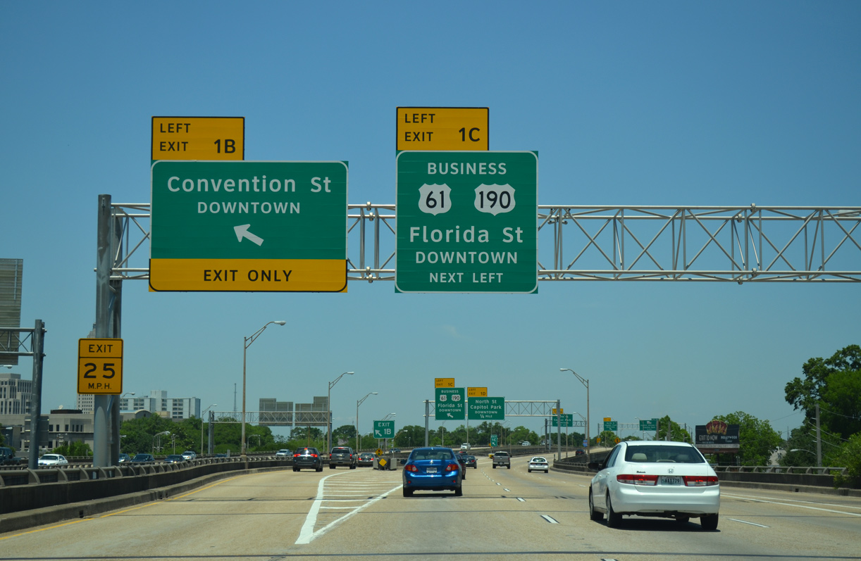
| Northbound Interstate 110 expands to four lanes to the left side ramp (Exit 1B) for Convention Street west to Downtown Baton Rouge. An adjacent ramp quickly follows for U.S. 61-190 Business (Florida Boulevard) east through Midtown. 05/19/14 |
|
| Convention Street leads west through southern reaches of Downtown Baton Rouge to the Mississippi Riverfront near the River Center concert and sports arena. Exit 1B also connects with East Boulevard south back to LA 73 (Government Street). 05/19/14 |
|
| U.S. 61-190 Business form a convoluted route joining Downtown Baton Rouge with Airline Highway at Broadmoor to the east, and Scenic Highway north to Scotlandville. Exit 1C lowers to intersect Florida Boulevard east at 10th Street. 05/19/14 |
|
| The first confirming marker for Interstate 110 appears as the northbound viaduct passes over Convention Street. 05/19/14 |
|
| The third successive left side ramp (Exit 1D) departs for North Street west to State Capitol Park at 4th Street. 05/19/14 |
|
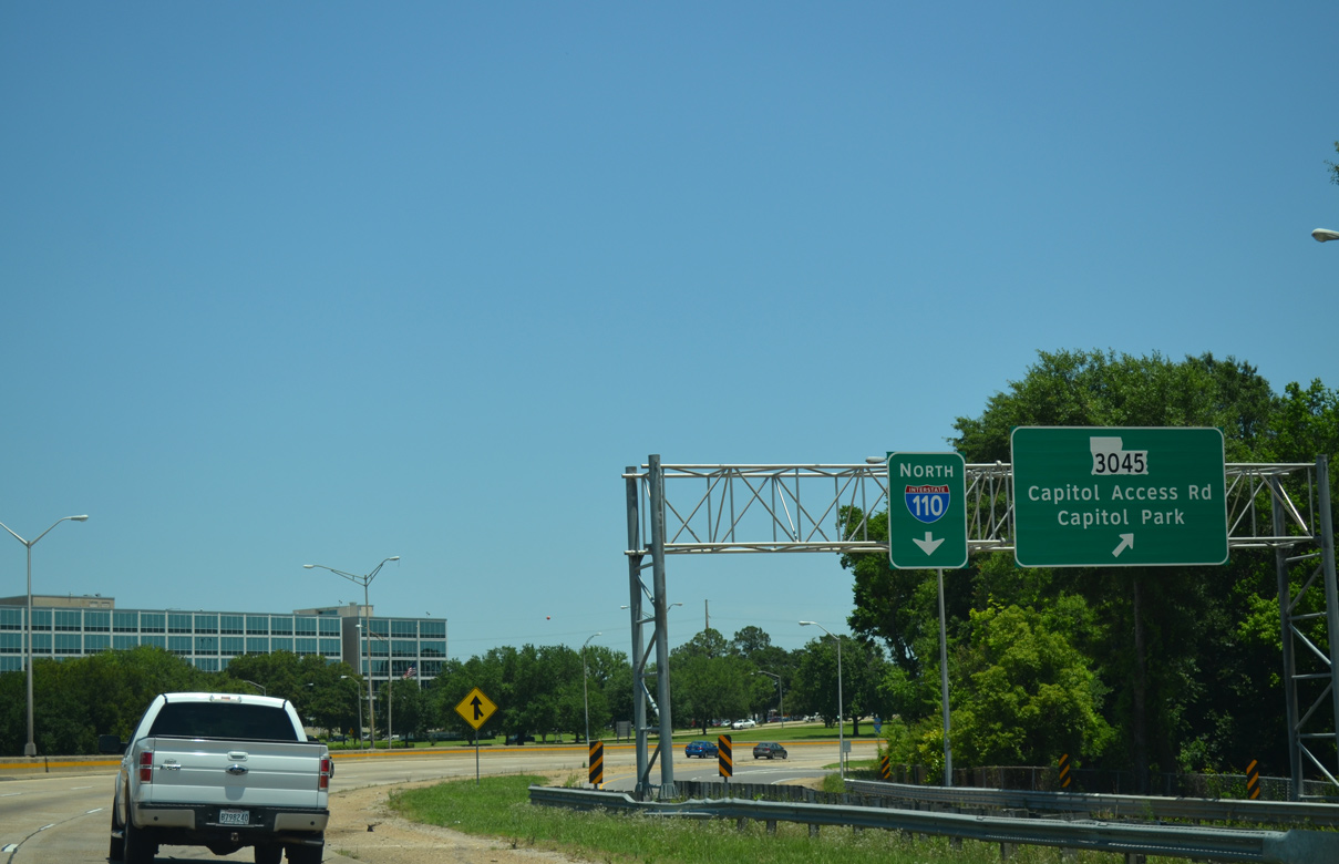
| North Street runs along northern reaches of Downtown Baton Rouge west from Exit 1D to U.S. 61-190 Business (River Road). I-110 lowers to grade level briefly ahead of the upcoming ramp (Exit 1E) for LA 3045 (Capitol Access Road / West Highway Drive). 05/19/14 |
|
| The Main Street on-ramp forms a northbound auxiliary lane to the collector distributor roadway (Exit 1E) for the State Capitol. 05/19/14 |
|
| Exit 1E separates from Interstate 110 north on the 90 degree turn by Capitol Lake. LA 3045 lines a 0.24 mile segment of Capitol Access Road west to Arsenal Park, and a 0.25 mile section of West Highway Drive north to LADOTD headquarters. 05/19/14 |
|
| The 10th Street northbound on-ramp merges with the Exit 1E c/d roadway just ahead of the trumpet interchange with LA 3045 (Capitol Access Road). 05/19/14 |
|
| A 1958-built overpass carries motorists to LA 3045 above Interstate 110. The oldest portion of the Baton Rouge Expressway travels east from Capitol Lake to Memorial Stadium and LA 67 (22nd Street). 05/19/14 |
|
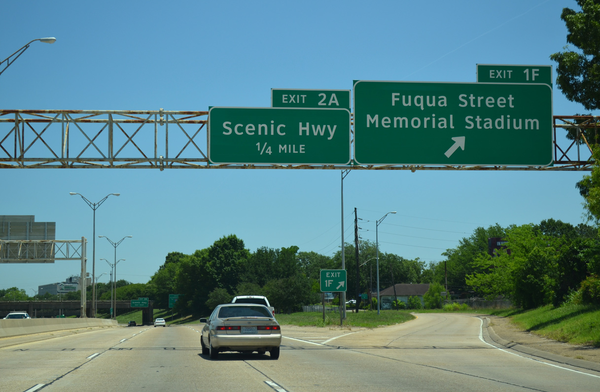
| Fuqua Street stems east from upcoming Exit 1F to join I-110 with 19th Street north to Memorial Stadium and Goldsby Field. 05/19/14 |
|
| Exit 1E parts ways with Interstate 110 north for Fuqua Street east to LA 67 (22nd Street) and the Eden Park neighborhood. A loop ramp quickly follows for LA 3164 (Scenic Highway) north. 05/19/14 |
|
| I-110 north to U.S. 190 (Airline Highway) doubles as part of an emergency detour for Interstate 10 west across the Mississippi River. U.S. 190 splits with U.S. 61 at Scenic Highway just west of Exit 5B. Further south Scenic Highway parallels I-110 beside oil refinery complexes. 05/19/14 |
|
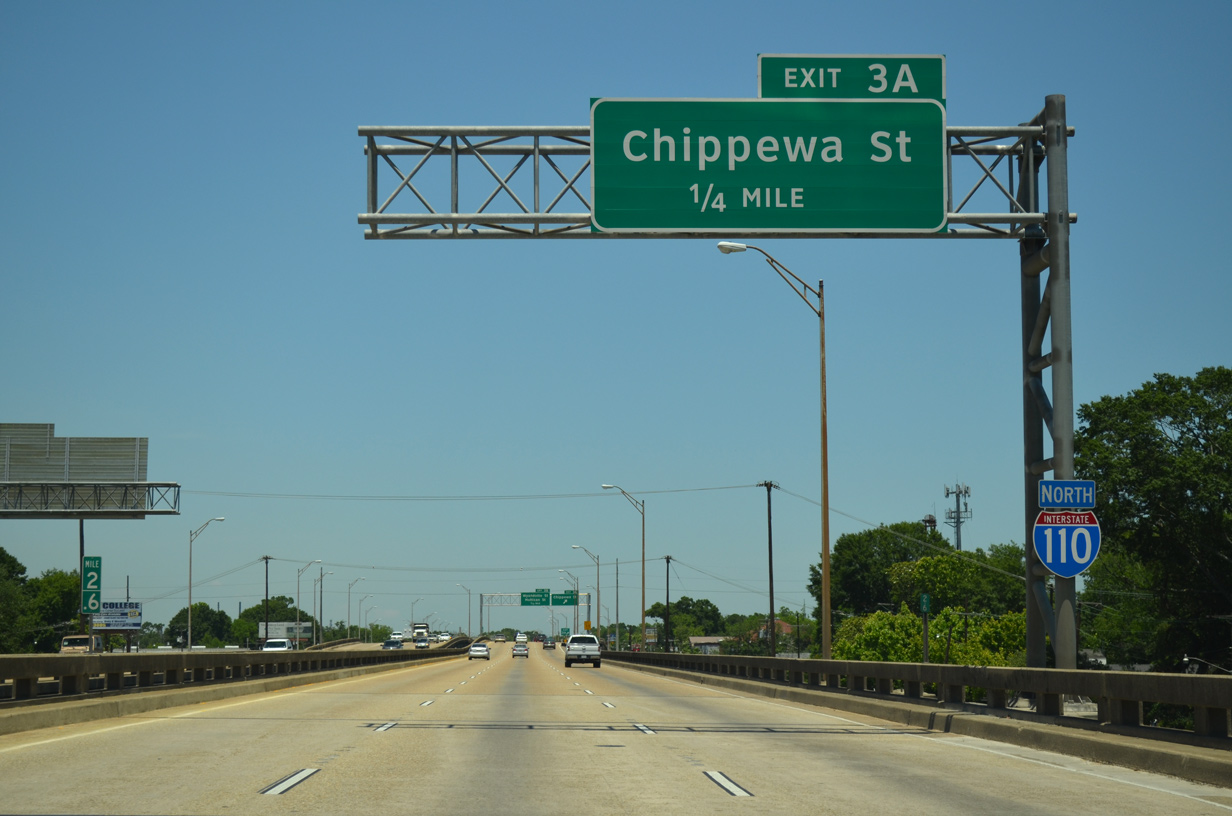
| Unmarked LA 3164 begins at Exit 2A and follows the initial leg of Scenic Highway north to U.S. 61-190 Business (Chippewa Street). Chippewa Street meets Interstate 110 directly in three quarters of a mile. 05/19/14 |
|
| Interstate 110 makes a sweeping curve northward from the 1963-completed Baton Rouge Expressway to the 1970-built viaduct system heading north to Chippewa Street (Exit 3A). 05/19/14 |
|
| A diamond interchange (Exit 3A) joins I-110 with Chippewa Street at Hiawatha and Pocahontas Streets. Chippewa Street leads east five blocks to LA 67 (Plank Road). The arterial street west carries U.S. 61-190 Business from adjacent Scenic Highway to the Standard Heights area. 05/19/14 |
|
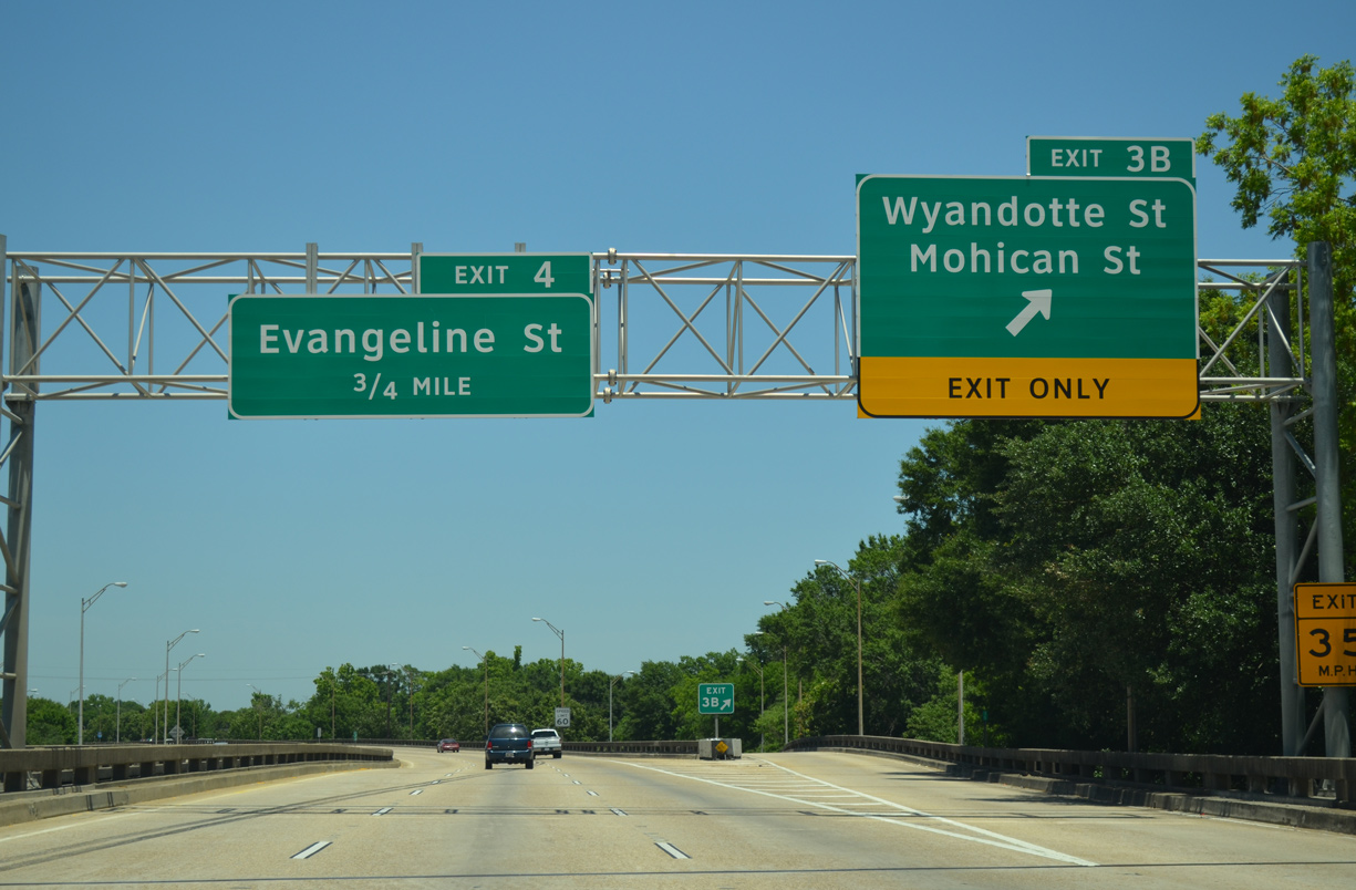
| Continuing north, Interstate 110 shifts east a block and a half to a split diamond interchange (Exit 3B) with Wyandotte Street, Mohican Street and Weller Avenue. 05/19/14 |
|
| A lane drop occurs as Exit 3B lowers to Baton Rouge Avenue at Wyandotte Street. Mohican Street links Interstate 110 with the Istrouma neighborhood to the east and the industrial area along Scenic Highway to the west. 05/19/14 |
|
| Baton Rouge Avenue north and Nokomis Street south form frontage roads for I-110 through a mostly vacant street grid at Exit 3B. 05/19/14 |
|
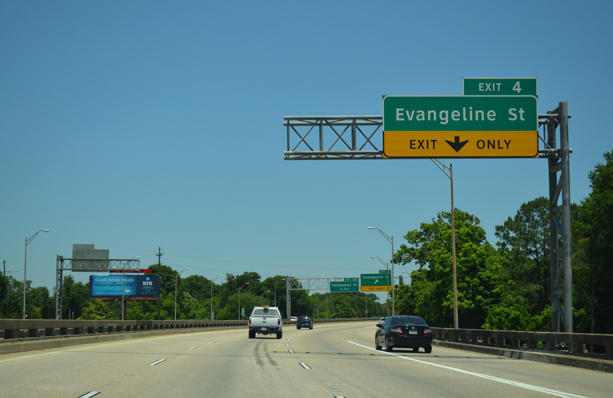
| A short auxiliary lane runs from the Baton Rouge Avenue on-ramp to Exit 4 (Evangeline Street). 05/19/14 |
|
| Evangeline Street stems east from U.S. 61-190 Business (Scenic Highway) to a diamond interchange (Exit 4) with I-110. The urban arterial continues east to the Delmont Place, North Highlands and Brookstown communities. 05/19/14 |
|
| Curving northeast, motorists on I-110 north next meet Hollywood Street at Exit 5A. 05/19/14 |
|
| Hollywood Street meets I-110 at a half diamond interchange (Exit 5A) to the north of Delmont Place. U.S. 61 & 190 (Airline Highway) cross paths with the freeway next. 05/19/14 |
|
| Spanning Monte Sano Bayou, I-110 north approaches the flyover ramps for U.S. 61 & 190 (Airline Highway). Airline Highway is a limited highway west from Exit 5A to the U.S. 61 and 190 split at Scenic Highway and east through the adjacent cloverleaf interchange with LA 67 (Plank Road). 05/19/14 |
|
| Interstate 110 north maintains three through lanes as Exit 5B separates for U.S. 61 & 190 (Airline Highway). Opelousas lies 58 miles to the west along U.S. 190 at the junction with Interstate 49. U.S. 61 follows Airline Highway east from Baton Rouge to New Orleans. 05/19/14 |
|
| Beyond the split with U.S. 61 (Scenic Highway). U.S. 190 crosses the Mississippi River Bridge into West Baton Rouge Parish. Airline Highway (U.S. 61 & 190) southeast constitutes a commercial arterial to Castlewood and Cortana Mall. 05/19/14 |
|
| Exit 6 departs a half mile north of the symmetrical stack interchange with U.S. 61 & 190 (Airline Highway) for LA 408 (Harding Boulevard) at Baton Rouge Metropolitan Airport (BTR). 05/19/14 |
|
| The four level interchange with Airline Highway was completed in 1976. 05/19/14 |
|
| Ramps from U.S. 61 & 190 combine to form a distributor roadway north to LA 408 (Harding Boulevard). 05/19/14 |
|
| Interstate 110 bends westerly as Exit 6 partitions for LA 408 west to Southern University and east to Howell and the city of Central. Veterans Memorial Boulevard stems north from the ramp end and Harding Boulevard to the passenger terminal of Baton Rouge Metro Airport (BTR). 05/19/14 |
|
| The viaduct system over LA 408 and Badley Road was constructed in 1982. 05/19/14 |
|
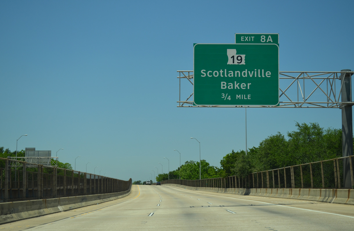
| Interstate 110 veers northwest toward Scotlandville and a half diamond interchange (Exit 8A) with LA 19 (Scotland Avenue). 05/19/14 |
|
| LA 19 commences a 34 mile route north to the Mississippi state line from U.S. 61 (Scenic Highway) near Southern University. The state highway bee lines northward from Exit 8A to Maryland and the cities of Baker and Zachary. 05/19/14 |
|
| Motorists partition for the two lane off-ramp (Exit 8A) to LA 19 (Scotland Avenue) and the last segment of I-110 west to U.S. 61 (Scenic Highway). 05/19/14 |
|
| Interstate 110 advances west at grade level to the two-wye interchange (Exit 8B) with U.S. 61 (Scenic Highway). Traffic counts drop substantially, with 52,202 vehicles per day (vpd) recorded by LADOTD in 2014 south of Exit 8A, and 29,212 vpd ahead of Exit 8B. 05/19/14 |
|
| A pair of end signs precede the split of Exits 8B/C. U.S. 61 forms an arterial route north from Scotlandville to exit the city at North Maryland. 05/19/14 |
|
| U.S. 61 (Scenic Highway) ventures 22 miles northwest to the West Feliciana Parish seat of St. Francisville and 80 miles to Natchez, Mississippi. 05/19/14 |
Page Updated 03-30-2017.

 North
North