
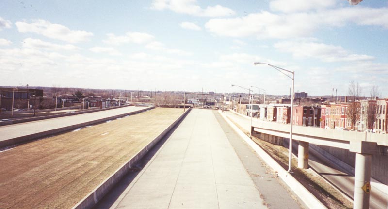
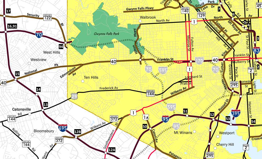
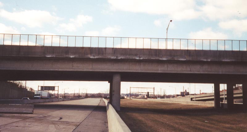
Looking westward from the Monroe Street (U.S. 1 south) overpass at the end of the freeway built for Interstate 170 in Baltimore, Maryland. This section was demolished in 2011 and graded in 2014 for the West Baltimore MARC Station parking lots. 01/02/01
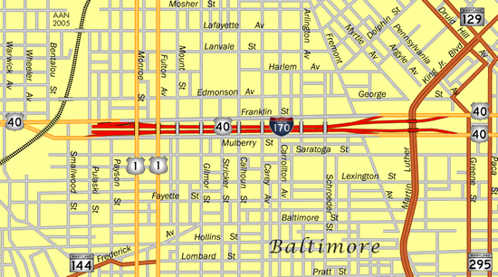
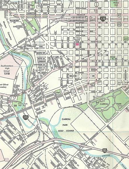
Interstate 170 was the planned freeway spur for Downtown Baltimore from I-70 to the west. A 1.34 mile long section of the route was constructed in the late 1970s in a residential area west of Greene/Paca Streets (MD 295). Vastly below grade, the short freeway opened amid controversy in 1979. U.S. 40 remained on the parallel couplet of Franklin and Mulberry Streets until 1983 when I-170 was formally decommissioned. Construction of the freeway hastened the urban blight of the area community. The proposed MARC Red Line was envisioned to help improve the area, but it too was eventually canceled.
The freeway for Interstate 170 west of Downtown Baltimore. The I-170 designation was removed when Interstate 70 was formally canceled within the Baltimore city limits.
When plans for I-70 through Leakin and Gwynns Falls Park were dropped in 1981, it severed the connection with Interstate 170. Construction of that freeway was canceled due to the impacts to both Gwynn Falls Park and residential areas to the east. A subsequent proposal followed to incorporate the Franklin-Mulberry Expressway into a longer spur, Interstate 595 north from I-95 at Carroll Park. When I-595 was also cancelled, U.S. 40 was realigned onto the Franklin-Mulberry Expressway.
| Pulaski Street |
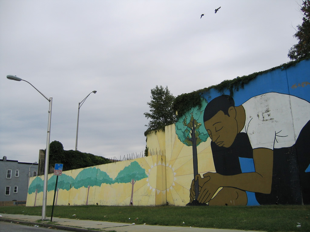 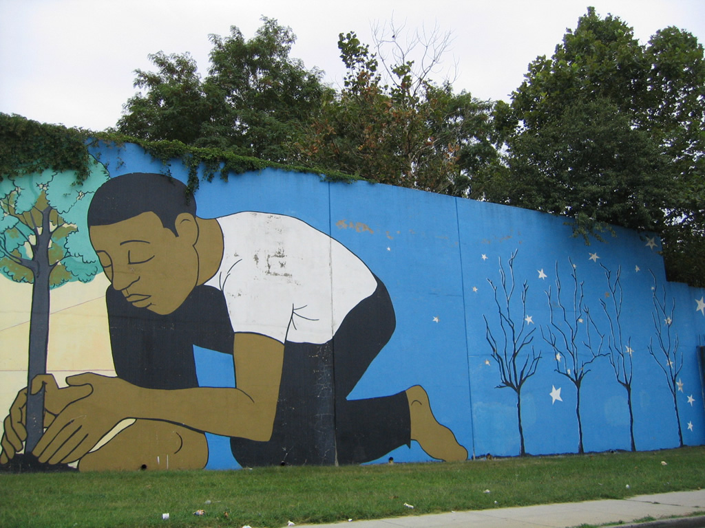   | Looking at the western end of the Interstate 170 stub freeway from Pulaski Street. A large mural was painted on the concrete wall that was intended to support unconstructed Interstate 170. Demolition of the freeway stub commenced September 10, 2010. The $2.5 million project razed the unused freeway elements between Pulaski and Monroe Streets. A subsequent $6 million project through summer 2011 constructed two new parking lots for the adjacent MARC West Baltimore station nearby.1 08/27/05, 06/20/12 |
 / Former / Former  East East |
 | Looking back to the west at non-existent oncoming traffic on the eastbound roadway of former Interstate 170. Concrete barriers prevent drivers from continuing west to the freeway drop-off at Pulaski Street. This stretch of unused roadway was removed by summer 2011 as part of a $2.5 million project to clear land for an expanded MARC parking lot facility east of Pulaski Street. 01/02/01 |
 | The freeway travels below grade alongside Mulberry Street (east) and Franklin Street (west). A series of overpasses carry both vehicular and pedestrian traffic above. 08/27/05 |
 | Traveling east at the Carollton Street pedestrian overpass on U.S. 40. The freeway median remains empty as it represents an unconstructed leg of the Baltimore Metro line. The proposed Red Line of MARC will utilize this corridor if built as envisioned. A 2016-completion date was being touted as of 2011. 08/27/05 |
 | U.S. 40 approaches the Social Security Building and Greene Street (MD 295 south). 08/27/05 |
| Mulberry Street - East |
 | Eastbound on Mulberry Street (former U.S. 40 east) at what was the partially built off-ramp from unconstructed Interstate 170 eastbound to U.S. 1 (Monroe Street/Fulton Avenue). 10/14/01 |
 | 2010-11 demolition of the unused freeway west of Fulton Avenue removed the majority of the partially built exit ramp meant to link I-170 with U.S. 1. 06/20/12 |
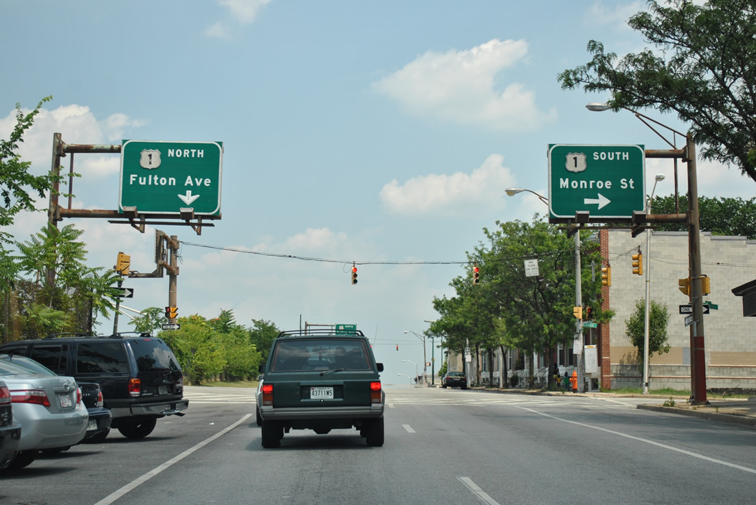  | Button copy overheads posted along Mulberry Street east at Monroe Street south. These were intended to direct traffic from Interstate 170 to U.S. 1. 06/20/12 |
 | Paralleling U.S. 40 along the Franklin-Mulberry Expressway, Mulberry Street proceeds one block east from U.S. 1 south on Monroe Street to U.S. 1 north on Fulton Avenue. 06/20/12 |
 | Continuing eastward on Mulberry Street between U.S. 1 north (Fulton Street) and Mount Street. Older row homes, most of which are in a neglected or vandalized state, front both Mulberry and Franklin Streets above the below grade freeway. 06/20/12 |
 | Eastbound at the intersection with Gilmor Street, one block after Mount Street. 06/20/12 |
 | Mulberry Street east at Carey Street. 06/20/12 |
 | Mulberry Street eastbound at Carrollton Avenue. Stricker Street and Carrollton Avenue are discontinuous due to the Interstate 170 freeway. Pedestrian overpasses cross above the freeway between the separate sections. 06/27/10 |
 | Arlington Avenue flows northward from Saratoga Street one block to intersect Mulberry Street en route to Fremont Avenue and Pitcher Street. 06/20/12 |
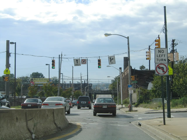
 | Mulberry Street east at Schroeder Street. The former Interstate 170 freeway emerges ahead to pass over Martin Luther King, Jr. Boulevard as Mulberry Street descends to intersect the six lane boulevard below. 06/20/12 |
 | Button copy overheads above the I-170 freeway at the MLK Boulevard off-ramp. U.S. 40 remains on the freeway eastward to Orleans Street at St. Paul Place, north of Downtown Baltimore. 10/10/04 |
 | Traffic from U.S. 40 eastbound merges onto Mulberry Street ahead of Martin Luther King, Jr. Boulevard (Biddle Street). Martin Luther King, Jr. Boulevard loops west of Downtown Baltimore between Chase Street and the western branch of I-395. The boulevard north connects US 40 with the Mount Vernon neighborhood. 06/20/12 |
 | Mulberry Street eastbound at Martin Luther King, Jr. Boulevard. The six lane arterial intersects Lombard & Pratt Streets just west of the central business district. From there the boulevard continues to Camden Yards and directly onto the southbound beginning of Interstate 395. Mulberry Street continues east with U.S. 40 to Orleans Street near I-83. 06/20/12 |
| Franklin Street - West |
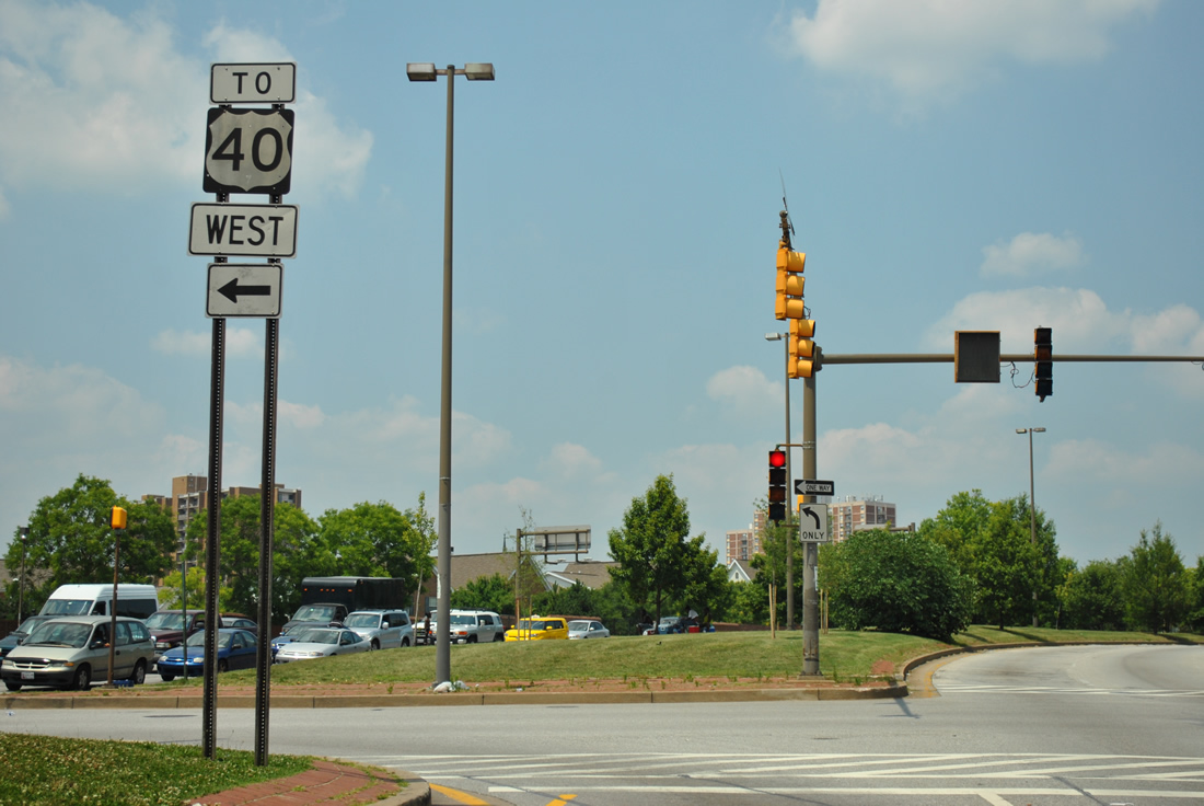
 | A look at the Franklin Street on-ramp to U.S. 40 from just west of Martin Luther King, Jr. Boulevard. The overhead originally displayed "Interstate 170 west". 06/20/12 |
 | An overhead for U.S. 1 (Monroe Street) south and the unopened on-ramp to Interstate 170 westbound along Franklin Street west. U.S. 40 was to remain on Franklin and Mulberry Streets and continue west to Edmondson Avenue as Interstate 170 veered southwest to meet I-70 at Gwynns Falls Park. 06/27/10 |
 | The stub end of the Interstate 170 freeway, the partially completed on-ramp, an empty sign bridge and light posts installed in 1979 appeared beyond Monroe Street. Demolition of the unused roadway west of Monroe Street commenced in September 2010. 10/13/04 |
 | The U.S. 1 on-ramp via Franklin Street crosses over the U.S. 40 westbound off-ramp from former Interstate 170. 10/13/04 |
 | U.S. 40 and Franklin Street converge at the intersection with Pulaski Street two blocks west of U.S. 1 (Monroe Street) south. A concrete barrier separated traffic from the merging U.S. 40 and Franklin Street. 10/13/04 |
| Martin Luther King, Jr Boulevard - North |
 | Martin Luther King, Jr. Boulevard acts as a connector between the western branch of Interstate 395 and U.S. 40 (Franklin/Mulberry Streets), providing a through route around the western edge of Downtown. 05/31/04 |
  | Button copy signage on Martin Luther King, Jr. Boulevard north included a shield for Interstate 170 west when the route was signed between 1979 and 1983. 10/14/01, 05/31/04 |
 | U.S. 40 returns to Mulberry Street from Franklin-Mulberry Expressway (old I-170) just east of Martin Luther King, Jr. Boulevard. 05/31/04 |
  | A second guide sign formerly referencing U.S. 40 west to Interstate 170 appears along Martin Luther King, Jr. Boulevard north at Franklin Street. 10/14/01, 06/20/12 |
 | U.S. 40 trailblazer posted at the left turn onto Franklin Street. The freeway entrance ramp is located nearby. 06/20/12 |
- "'Highway to Nowhere' heads to the dump." The Baltimore Sun, September 10, 2010.
- Interstate 170 (Maryland). Wikipedia.org.
Photo Credits:
01/02/01, 10/14/01, 05/31/04, 10/10/04, 10/13/04, 08/27/05, 06/27/10, 06/20/12 by AARoads
Connect with:
U.S. 40
Page Updated 11-04-2022.