|
| I-295/U.S. 40 lower from Delaware Memorial Bridge into Pennsville township. The two routes separate 0.8 miles from the state line at the New Jersey Turnpike. 08/19/21 |
|
| U.S. 40 leads east from Interstate 295 to various routes leading south to the Cape May-Lewes Ferry. U.S. 40 in the Garden State travels 64.32 miles from the Delaware Memorial Bridge to Atlantic and Pacific Avenues in Atlantic City. 08/19/21 |
|
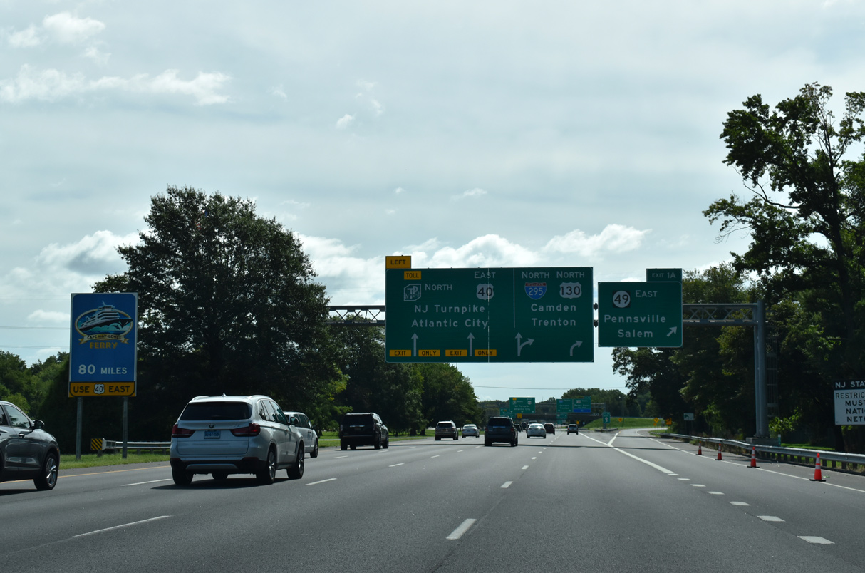
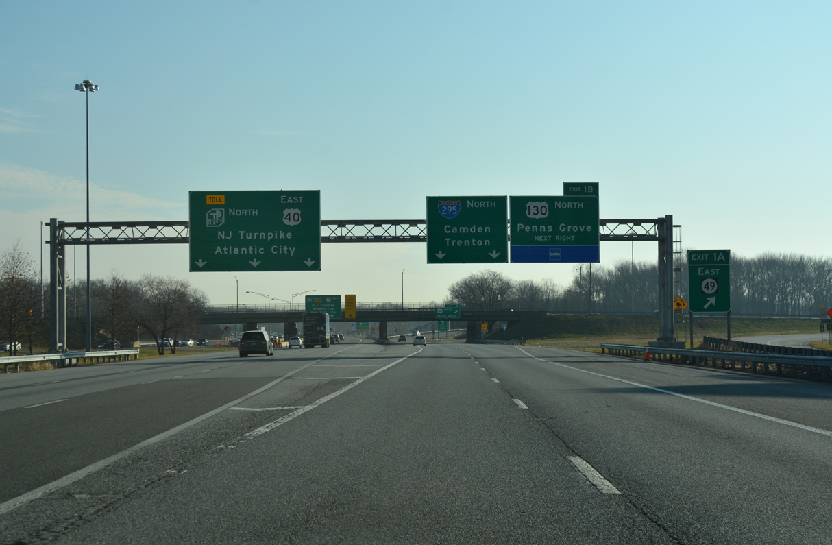
| A three quarter cloverleaf interchange connects I-295/U.S. 40 with Route 49 at Exit 1 A east and U.S. 130 north at Exit 1 B. The Delaware River and Bay Authority (DRBA) maintains I-295 from I-95 eastward to the New Jersey Turnpike. 08/19/21 |
|
| Route 49 straddles coastal areas along the Delaware River southeast nine miles to the Salem County seat of Salem. Overall the state route travels 53.80 miles to Route 50 at Tuckahoe in Upper Township. 12/27/18 |
|
| Traffic partitions with three lanes for U.S. 40 east to Atlantic City and the New Jersey Turnpike north to New York and two for Interstate 295 north to Camden. Exit 1 B follows for U.S. 130 (Broadway) north into Deepwater. 12/17/17 |
|
| Exit 1 B connects with U.S. 130 (Broadway) north to Deepwater, Carneys Point and Penns Grove. An intrastate highway, U.S. 130 travels 83.46 miles northeast from I-295 at Deepwater to U.S. 1 at North Brunswick Township in North Jersey. 12/27/18 |
|
| U.S. 40 eastbound splits with the adjacent New Jersey Turnpike nearby for Woodstown, Pole Tavern, Elmer, Mays Landing and Atlantic City. U.S. 40 initiall parallels the toll road along a four lane, divided highway east four miles to Route 48. 12/27/18 |
|
| U.S. 130 heads north through Carneys Point Township and the borough of Penns Grove before returning to Interstate 295 east through Logan Township. 12/27/18 |
|
| Exit 1 B loops onto U.S. 130 (Broadway) ahead of Salem Canal and the unincorporated community of Deepwater. Salem Community College follows to the northeast in Carneys Point Township. 12/27/18 |
|
| Hook Road (CR 551) branches north from Route 49 to bypass Pennsville and connect with I-295 north at Exit 1C. 12/27/18 |
|
| Interstate 295 turns northward at Exit 1 C to Hook Road (Salem County Route 551). CR 551 travels 4.66 miles south from I-295 to Route 49 near Harrisonville. 12/27/18 |
|
| Forthcoming Exit 2 A provides access from Hook Road (CR 551) northbound to I-295 south / U.S. 40 west for the Delaware Memorial Bridge. 12/27/18 |
|
| The loop ramp at Exit 2 A links with U.S. 40 west at the south end of the New Jersey Turnpike just ahead of Interstate 295. 12/27/18 |
|
| Exits 2 B-C provide additional access to U.S. 40 east to Atlantic City and U.S. 130 north for Penns Grove. The parclo interchange joins Route 140 (Hawks Bridge Road) just north of the New Jersey Turnpike split with U.S. 40 (Wiley Road). Route 140 is a 0.96 mile long link between the two US highways. 12/27/18 |
|
| Route 140 (Hawks Bridge Road) passes over I-295 one half mile south of a rest area and tourist information center. Route 140 transitions into CR 540 south of U.S. 40 en route to Route 45 outside of Salem. 12/27/18 |
|
| Privatized and renamed to the Adventure Aquarium in 2004, the former New Jersey State Aquarium opened to visitors in 1995 at the city of Camden. Various signs are posted throughout the state directing motorists to the attraction including one along I-295 northbound at milepost 2. 12/27/18 |
|
| The New Jersey State Welcome Center at Carneys Point Township lies adjacent to CR 551 (Pennsville Auburn Road). 12/27/18 |
|
| The first Interstate 295 northbound confirming marker in the Garden State. 12/27/18 |
|
| Interstate 295 originally ended near Ewing at U.S. 206 but was truncated eastward to U.S. 1 when the Somerset Freeway for I-95 was canceled in 1982. 12/27/18 |
|
| The New Jersey Welcome Center is the lone rest area along Interstate 295 north. Closed in 2003, the second was located in Florence Township. 12/27/18 |
|
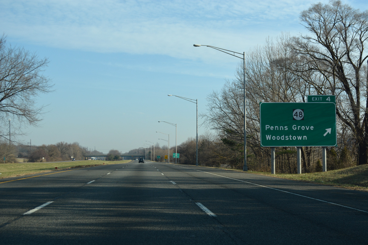
| Interstate 295 advances north to a weigh station and Exit 4 for Route 48. 12/27/18 |
|
| Route 48 (Harding Highway) runs 4.26 miles between U.S. 130 (Virginia Avenue) in Penns Grove and U.S. 40 (Wiley Road). 12/27/18 |
|
| The weigh station for commercial trucks lies just north of the Hollywood Avenue (CR 618) underpass along I-295. 12/27/18 |
|
| Georgetown Road (CR 629) crosses I-295 a quarter mile south of Exit 4 to Route 48. Route 48 once linked with the city of Wilmington, Delaware via the Wilmington-Penns Grove Ferry. A companion SR 48 continued from the ferry launch northwest to Downtown Wilmington at that time. When the first span of the Delaware Memorial Bridge opened in 1951, ferry service was discontinued. Route 48 ends at U.S. 130 in Penns Grove and SR 48 was turned back to U.S. 13 Business in Wilmington. 12/27/18 |
|
| Interstate 295 northbound at the parclo interchange (Exit 4) with Route 48 (Harding Highway). Route 48 feeds into U.S. 40 as the main route between Penns Grove and Carneys Point Township southeast to Woodstown. 12/27/18 |
|
| Northbound reassurance shield posted between Exit 4 / Route 48 and the Pennsgrove Auburn Road (CR 641) over crossing. 12/27/18 |
|
| Forthcoming Exit 7 serves Pedricktown and Auburn in Oldmans Township via Straughns Mill Road (CR 643). 12/27/18 |
|
| One half mile south of the diamond interchange (Exit 7) with CR 643 at the Perkintown Road (CR 644) overpass above I-295 north. 12/27/18 |
|
| Exit 7 departs I-295 north for CR 643 north to Five Points, west of Pedricktown, and U.S. 130. Straughns Mill Road south ties into CR 551 (Pennsville Auburn Road) east to Auburn in 1.8 miles. 12/27/18 |
|
| One mile south of Exit 10 to Center Square Road (CR 620) at the Pedricktown Woodstown Road (CR 602) overpass. Center Square Road travels south from U.S. 130 near Nortonville to the borough of Swedesboro. 12/27/18 |
|
| Interstate 295 crosses Oldmans Creek into Gloucester County. Following the county line is the six-ramp parclo interchange (Exit 10) with Center Square Road (CR 620). 12/27/18 |
|
| Northbound I-295 at Exit 10 to Center Square Road. Swedesboro is located 3.5 miles to the southeast at the junction of CR 551 (Auburn Road) and CR 538 (Franklinville Road). 12/27/18 |
|
| U.S. 322 converges with Interstate 295 in Logan Township at Exit 11. U.S. 322 represents the second Delaware River crossing from the south, spanning the waterway between Bridgewater and Chester, Pennsylvania over the Commodore Barry Bridge. 12/27/18 |
|
| Removed after 2014, this Interstate 295 northbound confirming marker was posted after the High Hill Road (CR 662) over crossing. 12/29/08 |
|
| Exit 11 A leaves I-295 north in a half mile for U.S. 322 east toward Swedesboro, Mullica Hill and Glassboro. U.S. 322 also provides the first connection between I-295 and the New Jersey Turnpike since the toll road began at Deepwater. 12/27/18 |
|
| A three quarter cloverleaf interchange joins Interstate 295 with U.S. 322 at Exits 11 A/B. U.S. 322 travels six miles to the New Jersey Turnpike at Exit 2 and nine miles to Mullica Hill. 12/27/18 |
|
| Exit 11 B joins northbound I-295 with U.S. 322 west to the community of Bridgeport and the Commodore John Barry Bridge. Opened in 1972, the tolled cantilever bridge offers a direct route from I-295 and Gloucester County to I-95 at Chester, Pennsylvania. 12/27/18 |
|
| Interstate 295 traverses an area of wetlands adjacent to Moss Branch by this northbound shield assembly. 05/20/07 |
|
| Interstate 295 continues across wetland areas at Little Timber Creek, south of Cedar Swamp. 12/27/18 |
|
| U.S. 130 joins Interstate 295 at a wye interchange from an expressway leading east from U.S. 322 and Bridgeport. I-295 was built directly over U.S. 130 from Repaupo / Exit 14 and Greenwich Township to West Deptford Township in the 1960s. 12/27/18 |
|
| I-295/U.S. 130 combine ahead of a folded diamond interchange (Exit 14) with CR 684 (Repaupo Station Road). CR 684 connects the freeway with Route 44 (Crown Point Road) 0.75 miles to the north. 12/27/18 |
|
| Exit 14 loops away from I-295/U.S. 130 north onto CR 684 (Repaupo Station Road). Route 44 branches eastward 10.28 miles from Main Street in Bridgewater to Gibbstown, Paulsboro and Thorofare north of I-295. Route 44 represents the original alignment of U.S. 130 through Gloucester County. 12/27/18 |
|
| I-295/U.S. 130 run concurrently for 12 miles east through Gloucester County. Resurfacing replaced the concrete surface on this stretch in 2008. This shield assembly was removed during that work. 05/20/07 |
|
| I-295/U.S. 130 cross Repaupo Creek into Greenwich Township ahead of a compact folded diamond interchange (Exit 15) with CR 607 (Tomlin Station Road). 12/27/18 |
|
| CR 607 (Tomlin Station Road) begins 1.25 miles to the north of Exit 15 at Route 44 (W Broad Street) in Gibbstown. Southward the 9.39 mile long county route concludes at CR 694 (Monroeville Road) near Harrisonville. 12/27/18 |
|
| Removed by 2008, these Interstate 295 and U.S. 130 reassurance shields appeared by Greenwich Lake Park between Exits 15 and 16 A. 04/25/04 |
|
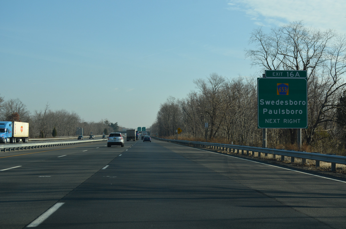
| CR 653 (Swedesboro Road) and CR 673 (Democrat Road) converge in close proximity to I-295/U.S. 130 in Greenwich Township. Swedesboro Road meets I-295 at a parclo B2 interchange (Exit 16 A) a quarter mile ahead of the folded diamond (Exit 16 B) with Democrat Road. 12/27/18 |
|
| Exit 16 A leaves I-295/U.S. 130 north for CR 653 (Swedesboro Road). Swedesboro Road meanders 4.8 miles southward to CR 551 and Swedesboro. Beyond Exit 16 A, CR 653 intersects Democrat Road and Harmony Road, Gibbstown area through roads, on the 1.5 mile stretch to Route 44 (Broad Street) at Paulsboro. 12/27/18 |
|
| CR 673 (Democrat Road) travels 3.8 miles southeast from Gibbstown to Mickleton. Changes made to I-295 between 2007 and 2008 added an auxiliary lane between the CR 653 entrance ramp and Exit 16 B. 12/27/18 |
|
| One half mile south of the parclo interchange (Exit 17) with Swedesboro Avenue and CR 680 (Harmony Road). This exchange was upgraded from a tight cloverleaf interchange with 15 mile per hour ramps. 12/27/18 |
|
| Like CR 673 to the west, CR 680 (Harmony Road) provides a connection between Gibbstown and Route 44 (Broad Street) with Mickleton in East Greenwich Township to the south. 12/27/18 |
|
| Exit 17 departs I-295/U.S. 130 north for Swedesboro Avenue to CR 680 (Harmony Road). Swedesboro Avenue straddles the Greenwich and East Greenwich Township line southwest toward Repaupo and north into Paulsboro. 12/27/18 |
|
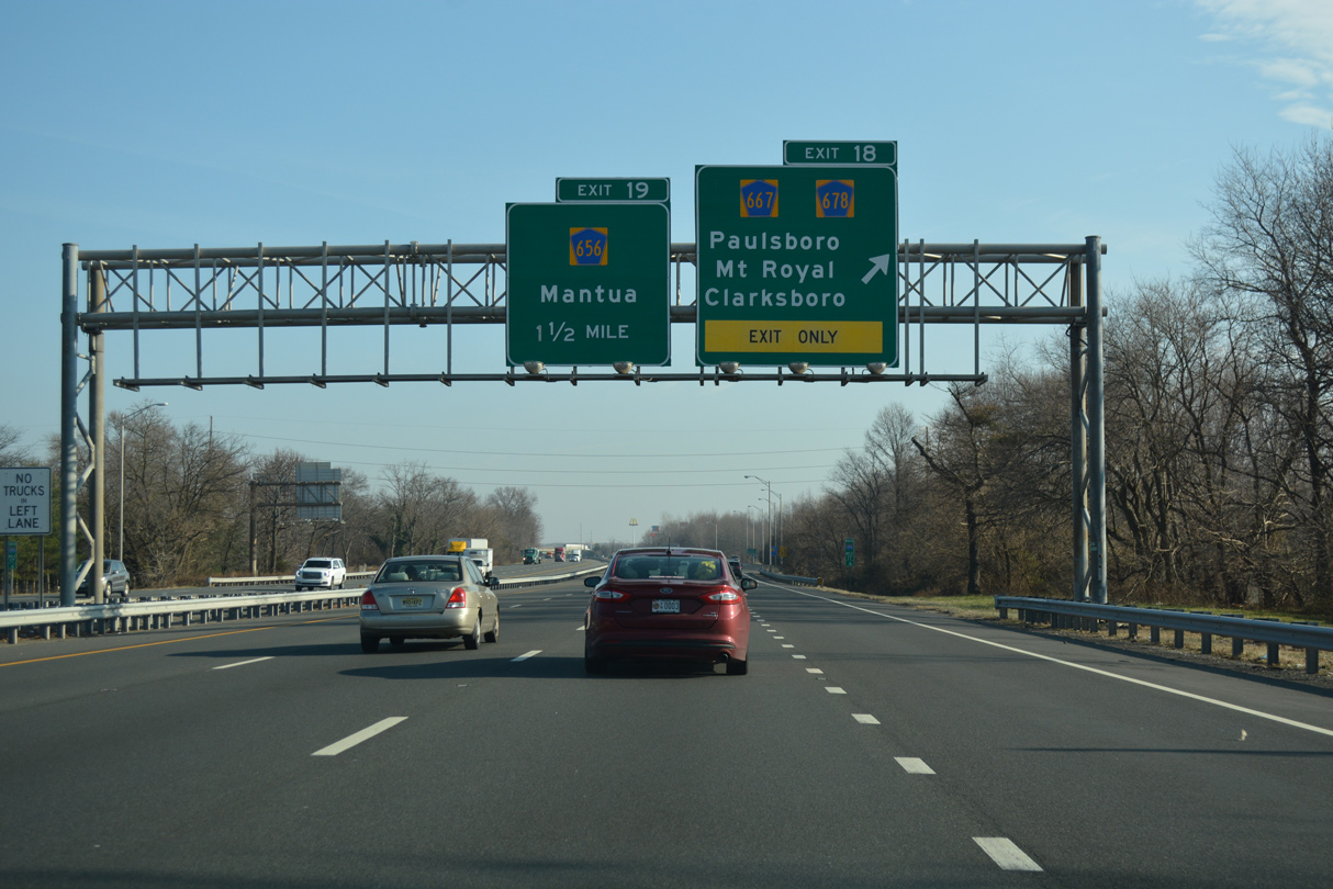
| The entrance ramp from Exit 17 forms a northbound auxiliary lane to Exit 18 for CR 678/667 at Paulsboro. 12/27/18 |
|
| CR 678 (Berkley Road) begins one mile west at Route 44 (Broad Street) in Paulsboro. CR 667 lines Delaware Street south from Route 44 to Exit 18 and Berkley Road. CR 667 follows Cohawkin Road south from CR 678 to Clarksboro while Berkley Road travels easterly to Mount Royal. 12/27/18 |
|
| I-295/U.S. 130 cross a causeway over Mantua Creek between Exit 18 and Gloucester County Route 656 (Mantua Grove Road). 12/27/18 |
|
| Entering West Deptford Township, I-295/U.S. 130 north reach the parclo interchange (Exit 19) with CR 656. CR 656 runs along Mantua Grove Road for two miles between parallel Route 44 (Crown Point Road) and CR 551 (Kings Highway) at Mantua Grove. 12/27/18 |
|
| Mid Atlantic Parkway meets I-295/U.S. 130 at Exit 20, 1.5 miles beyond the Mantua Grove Road overpass at the community of Thorofare. 12/27/18 |
|
| Exit 20 is a parclo interchange linking I-295 with Mid Atlantic Parkway at Friars Boulevard. Friars Boulevard extends 0.36 miles eastward from the northbound off-ramp to become CR 643 at Grove Road. CR 643 ties into CR 660 (Jessup Road) nearby. 12/27/18 |
|
| A four lane boulevard, Mid Atlantic Parkway loops 1.00 mile southeast from Route 44 through an industrial park to CR 643 (Grove Road). CR 643 travels south along Grove Road to Mantua Grove (CR 551) and north along Grove Avenue to National Park. CR 660 stems southeast 1.31 miles from CR 643 to CR 551, west of Woodbury. 12/27/18 |
|
| Sign changes made for Exits 21-22 by 2014 added CR 642 and CR 644. Forthcoming CR 640 (Delaware Street) joins Thorofare with the Gloucester County seat of Woodbury. 12/27/18 |
|
| The entrance ramp from Friars Boulevard and CR 643 (Grove Road) forms a fourth northbound lane to the c/d roadway for CR 640 (Delaware Street) and CR 631 (Crown Point Road). 12/27/18 |
|
| The parclo interchange at Exit 21 links with CR 640 (Delaware Street) south of adjacent Route 44. Delaware Street heads east to Woodbury city hall and Route 45 (Broad Street). 12/27/18 |
|
| Exit 21 leaves I-295/U.S. 130 north for CR 640 (Delaware Street) for Woodbury and the borough of National Park (via CR 643 north). CR 631 (Crown Point Road) represents the former alignment of U.S. 130 along the south side of I-295 from Woodbury Creek east to Exit 23. 12/27/18 |
|
| Exit 21 leaves I-295/U.S. 130 north for CR 640 (Delaware Street). Exit 22 follows onto Crown Point Road beyond Woodbury Creek. 12/27/18 |
|
| CR 631 (Crown Point Road) continues alongside the freeway to CR 644 (Red Bank Avenue) and CR 642 (Hessian Avenue) in West Deptford Township. CR 644 runs north from Woodbury to Red Bank on the Delaware River while CR 642 angles east between National Park and Route 45. 12/27/18 |
|
| U.S. 130 parts ways with I-295 north at a three quarter cloverleaf interchange (Exit 23) with Crown Point Road. U.S. 130 overtakes Crown Point Road en route to Westville, Brooklawn and Gloucester City. Ramps to U.S. 130 also tie into Academy Avenue nearby. 12/27/18 |
|
| Curving east to circumvent Westville and Bellmawr, I-295 crosses the original alignment of Crown Point Road. U.S. 130 turns more northerly from Exit 23 to Gloucester City and the east side of Camden. The two routes converge again at Exit 57. 12/27/18 |
Page Updated 11-18-2022.

 North
North  East
East


 East
East