|
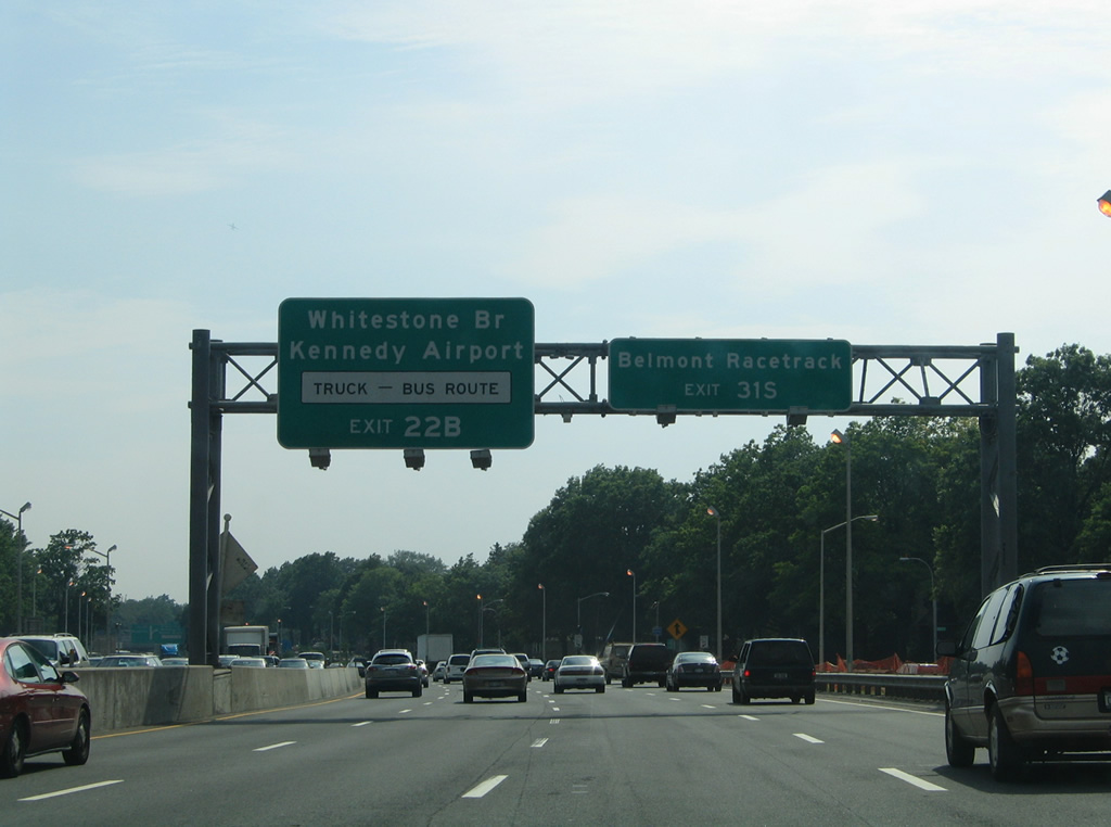
| Entering the Little Neck section of east Queens, Interstate 495 continues toward Exits 31N/S with Cross Island Parkway. The parkway is restricted to passenger vehicles only, so trucks and buses bound for either the Whitestone Bridge or Kennedy Airport must remain along the L.I.E. to Interstate 678 (Exit 22B). Otherwise Belt Parkway heads south along the New York City / Nassau County line to Belmont Park. 06/13/05 |
|
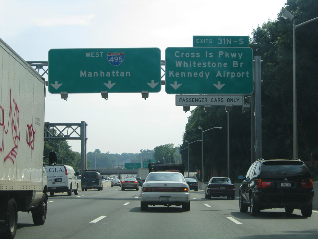
| All traffic to Cross Island Parkway departs in unison in one half mile at Exits 31N/S. A $130 million project was completed in 2003 that rebuilt both the original cloverleaf interchange with the parkway and removed the weaving movements between the Parkway off-ramp and Douglaston Parkway on-ramp. The three-year project replaced two loop ramps with flyovers, including the Exit 31S connection to Cross Island Parkway south.2 06/13/05 |
|
| The right lane of Interstate 495 west departs for Cross Island Parkway after the Douglaston Parkway overpass. The parkway links Malba and Beechhurst to the north and with the Southern State and Belt Parkways at Cambria Heights to the south. 06/13/05 |
|
| Exits 31N/S leave the Interstate 495 westbound mainline for Cross Island Parkway. The parkway provides the most direct route to both the Throgs Neck and Whitestone Bridges, which are the first bridges L.I.E. motorists can take to leave Long Island. 06/13/05 |
|
| Interstate 495 next meets Springfield Boulevard at the Exit 29 diamond interchange in one half mile. Drivers departing for Exit 31 lower below the Douglaston Parkway on-ramp before splitting into ramps for the parkway north to the Bronx and south to John F. Kennedy International Airport (JFK). 06/13/05 |
|
| Ramps split for Cross Island Parkway as both Interstate 495 and the parkway traverse Alley Pond Park. 06/13/05 |
|
| Passing under East Hampton Boulevard, Interstate 495 (Long Island Expressway) nears the Springfield Boulevard off-ramp (Exit 29) for the Bayside and Oakland Gardens neighborhoods. 06/13/05 |
|
| Exit 29 joins Horace Harding Expressway, the westbound service road, ahead of Springfield Boulevard near the vicinity of Queensborough Community College. Exit 28 follows in 0.75 miles for Oceana Street to Bayside and Cunningham Park. 06/13/05 |
|
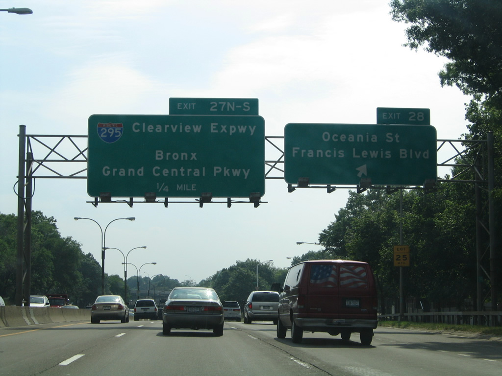
| The Oceana Street off-ramp precedes the directional interchange (Exits 27N/S) with Interstate 295 (Clearview Expressway) by one quarter mile. Drivers taking Exit 28 to Francis Lewis Boulevard follow the westbound frontage road beyond I-295 to the Auburndale and Fresh Meadows neighborhoods. 06/13/05 |
|
| Exit 28 departs Interstate 495 west as the Long Island Expressway nears the Clearview Expressway. Tallying 9.1 miles, Interstate 295 originates in the Queens Village neighborhood at NY 25 (Hillside Avenue) to the south. The freeway proceeds northward between Auburndale and Bayside to the Throgs Neck Bridge at Little Bay. 06/13/05 |
|
| Interstate 295 was numbered as Interstate 78 between 1958 and 1971, based upon the planned alignment of I-78 east from the Williamsburg Bridge along the proposed Bushwick and Nassau Expressways. When the southern extension of the Clearview Expressway was cancelled, I-78 was formally renumbered to Interstate 295.2.
Northward, Interstate 295 splits with Interstate 695 at Throgs Neck for the Bruckner Interchange with Interstates 95, 278, 678 and the Hutch. I-695 links I-295 north with I-95 north to New Rochelle, Rye and Connecticut. 06/13/05 |
|
| An on-ramp brings motorists onto Interstate 495 west from Francis Lewis Boulevard at Kissena Corridor Park. 06/13/05 |
|
| Replaced button copy signs precede the Exit 25 diamond interchange for Utopia Parkway, 164th Street and St. John's University. 06/13/05 |
|
| Utopia Parkway leads north from Interstate 495 to the Auburndale and Murray Hill communities and south through Utopia and Hillcrest. 164th Street parallels the parkway to the west through Kissena Park and Pomonok. 06/13/05 |
|
| Exit 24 also serves Pomonok in addition to CUNY Queens College via Kissena Boulevard south. North of the diamond interchange with Interstate 495, Kissena Boulevard angles westward to Downtown Flushing. 06/13/05 |
|
| Reassurance marker posted for Interstate 495 west at the 159th Street pedestrian over crossing. 06/13/05 |
|
| Ramp meters accompany many of the on-ramps to the Long Island Expressway through Queens. This assembly accompanies the Kissena Boulevard on-ramp. 06/13/05 |
|
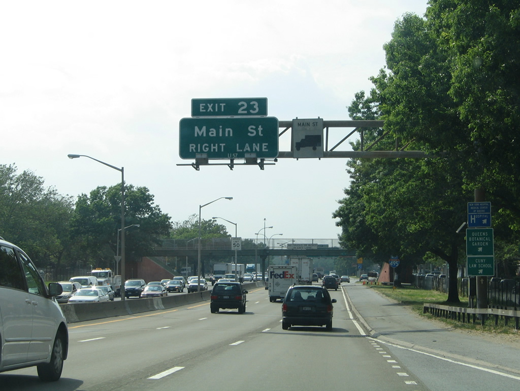
| Interstate 495 west enters the Queensboro Hill neighborhood and approaches the Exit 23 diamond interchange with Main Street. 06/13/05 |
|
| Row homes line both service roads (Horace Harding Expressway) as Interstate 495 nears the 148th Street pedestrian overpass by this westbound shield. 06/13/05 |
|
| The first guide sign (replaced by 2011) for Interstate 678 on I-495 west appears at the Main Street off-ramp (Exit 23). Main Street heads north from Interstate 495 to Downtown Flushing and NY 25A (Northern Boulevard). Southward the arterial street winds through Kew Gardens Hills to NY 25 (Queens Boulevard) at the Van Wyck. 06/13/05 |
|
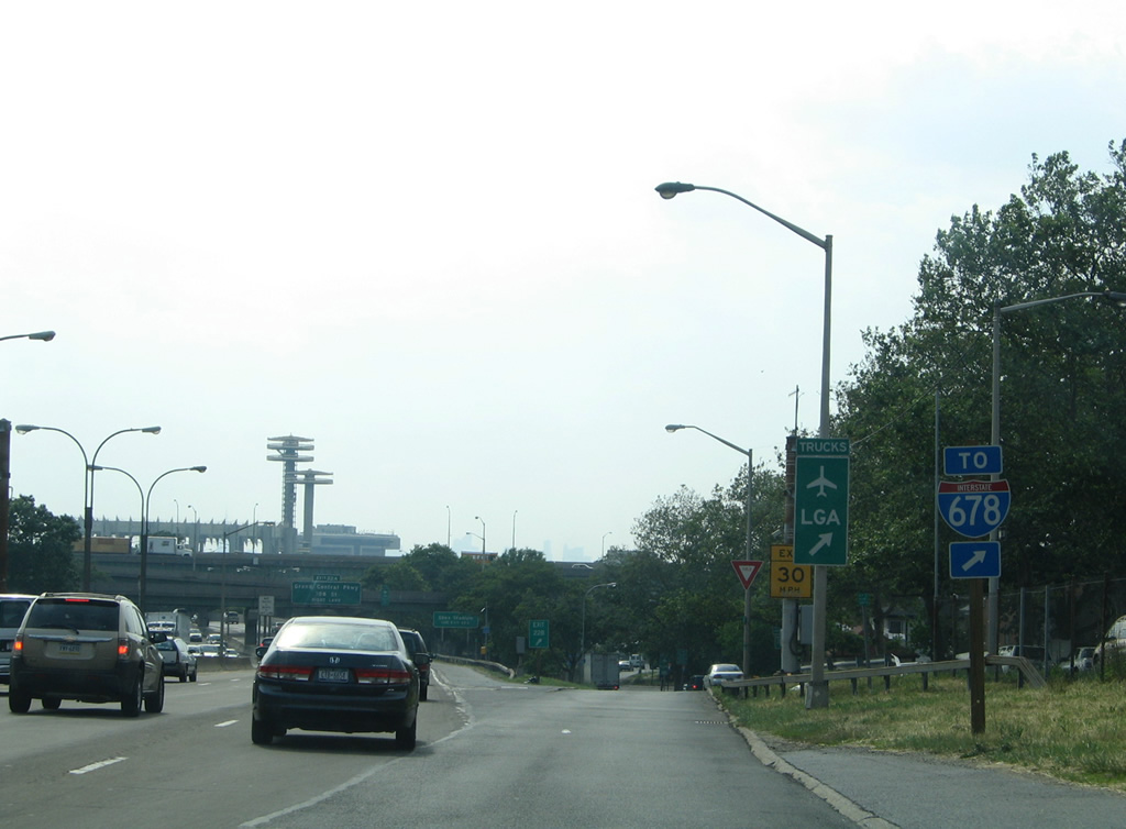
| Interstate 495 meets both Interstate 678 (Van Wyck Expressway) and Grand Central Parkway (GCP) at back to back interchanges (Exits 22B and 22A). Interests to LaGuardia Airport (LGA) are directed onto GCP northbound, though this does not include truck traffic due to the parkway's restriction to passenger vehicles only. 06/13/05 |
|
| An on-ramp adds traffic from Horace Harding Expressway at 138th Street just ahead of the Exit 22B. The directional interchange with Interstate 678 omits direct ramps from I-495 west. Instead motorists must use the ramps from College Point Boulevard to access the Van Wyck Expressway. 06/13/05 |
|
| Button copy signs (replaced by 2011) direct motorists to College Point Boulevard and its connections to Interstate 678. College Point Drive consists of a surface boulevard parallel to the Van Wyck Expressway from Flushing Meadows Corona Park northward to Flushing and College Point. The boulevard merges directly onto I-678 to the south for interests to South Jamaica, South Ozone Park and JFK International Airport. 06/13/05 |
|
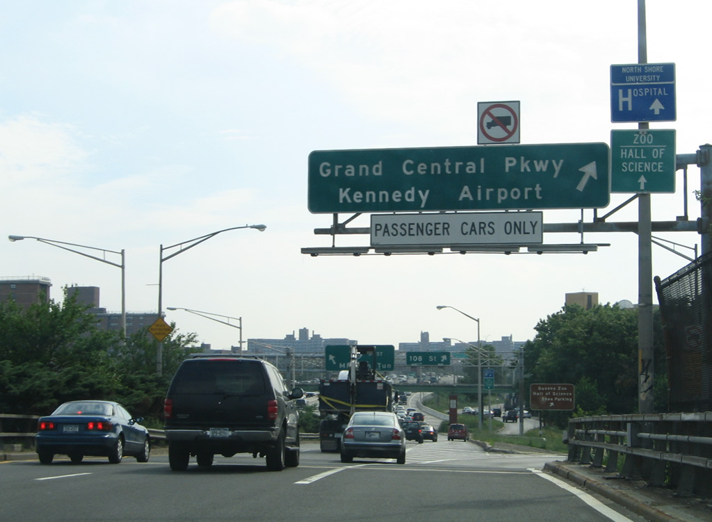
| Interstate 678 (Van Wyck Expressway) and Grand Central Parkway enclose Flushing Corona Park northward from their meeting at the Kew Gardens Interchange to Citi Field (home of the New York Mets MLB franchise). The 898-acre park is home to a bevy of attractions including Queens Zoo, the New York Hall of Science, the USTA National Tennis Center, the Queens Museum of Art and a number of sculptures and art created for the 1964 World's Fair. 06/13/05 |
|
| Visible in the distance beyond this reassurance marker along I-495 west is the abandoned New York State Pavilion built for the 1964 World's Fair. 06/13/05 |
|
| The sign bridge for the ramp departure of Exit 22B for College Point Boulevard and Interstate 678 was missing at the time of this photo. A trailblazer otherwise directs motorists onto Horace Harding Expressway west ahead of turns onto College Point Boulevard. The northbound on-ramp to the Whitestone Bridge and the Bronx departs from the boulevard north of 57th Road. 06/13/05 |
|
| Exit 22A follows as a collector distributor roadway for both the cloverleaf interchange with Grand Central Parkway and the resumption of Horace Harding Expressway west to 108th Street and the Corona neighborhood. 06/13/05 |
|
| Ramps from Interstate 678 to I-495 west pass over Exit 22A as it combines with an on-ramp from College Point Boulevard. Grand Central Parkway ventures north from Flushing Meadows Corona Park to East Elmhurst, LaGuardia Airport (LGA) and Astoria Heights. 06/13/05 |
|
| Grand Central Parkway north combines with Interstate 278 west ahead of the Triboro (RFK) Bridge. Interests to Citi Field, the USTA National Tennis Center and Queens Museum are directed onto the parkway north to Exits 9P or 9E. Drivers taking Grand Central Parkway north are restricted to vehicles not exceeding 10 feet 5 inches in height. 06/13/05 |
|
| A loop ramp joins a southbound c/d roadway along Grand Central Parkway as the parkway lines the Forest Hills community to the Kew Gardens Interchange with Interstate 678 and Jackie Robinson Parkway. East from that junction, the GCP continues to Jamaica, Utopia, Terrace Heights, and Queens Village. 06/13/05 |
|
| The Exit 22A c/d roadway partitions again with return access onto Interstate 495 west and the Horace Harding Expressway at Van Doren Street. 06/13/05 |
|
| The west end of the Queens-Midtown Tunnel includes a ramp that enters the city street grid at 37th and Tunnel Exit Streets. Motorists may turn left onto 37th Street west or continue north on Tunnel Exit Street for 38th to 41st Streets. 10/03/04 |
|
| Interstate 495 westbound traffic may also turn southward onto Tunnel Exit Street south below 36th Street to 35th and 34th Streets for their connections with 2nd and 3rd Avenues. Downtown based traffic interests should use 2nd Avenue south via 34th Street east. 10/03/04 |
Page Updated 08-21-2013.

 West
West