|
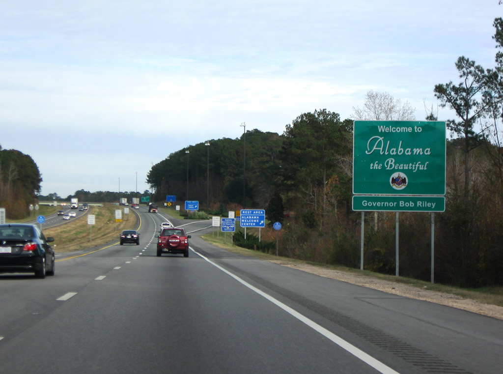
| The welcome sign for Alabama stands just beyond the state line where I-20 east / I-59 north enter Sumter County. 11/28/09 |
|
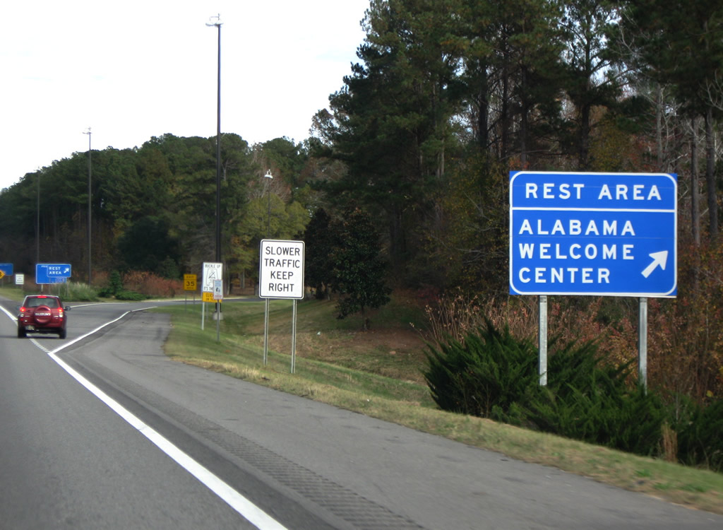
| A northbound rest area and tourist information center immediately follow the state line. 11/28/09 |
|
| I-20/59 north enter a diamond interchange (Exit 1) with unsigned SR 8 beyond the welcome center. This exchange marks the west end of High Priority Corridor 6, which overlays U.S. 80 eastward to Savannah, Georgia. SR 8 ties into U.S. 80 two miles away and continues along the route throughout the state. 11/28/09 |
|
| The city limits of Cuba extend to include a portion of the exchange joining SR 8 and I-20/59. The bridge identification sign lists the four lane highway as Spur U.S. 80, but no signs are posted for it along the route. Demopolis, where U.S. 80 ties into U.S. 43, is 34 miles to the east. 11/28/09 |
|
| I-20 east / I-59 north leave Cuba for York. 11/28/09 |
|
| Tuscaloosa is an hour drive northeast from Cuba along I-20 east / I-59 north. Sumter County Road 27 passes over the freeway in the distance. 11/28/09 |
|
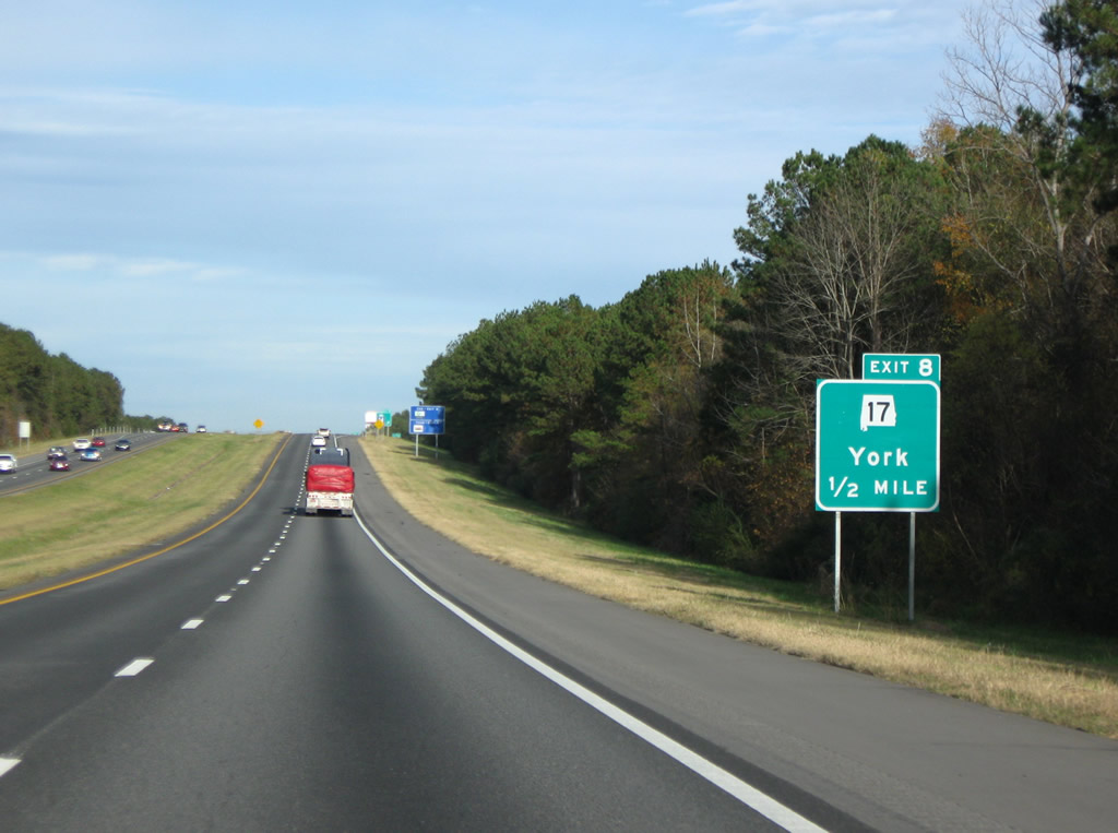
| I-20 east / I-59 north line the northern city limits of York between County Road 19 and the diamond interchange (Exit 8) with SR 17. 11/28/09 |
|
| Beginning in Mobile alongside U.S. 45, SR 17 comprises a 346.67 mile long route. Separating with U.S. 45 in Washington County, SR 17 continues north through the Black Belt region of Alabama all the way to the Tennessee State Line via Butler, Vernon, Hamilton, Russellville, Muscle Shoals and Florence. 11/28/09 |
|
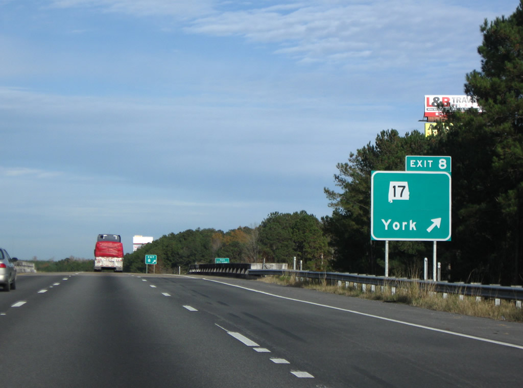
| Exit 8 departs I-20 east / I-59 north beyond an abandoned BNSF Railroad underpass. SR 17 follows Broad Street 2.33 miles south to U.S. 11 (4th Avenue) at the York city center. Northward, SR 17 continues 6.63 miles to Boyd. 11/28/09 |
|
| The rural drive along I-20/59 continues northeast from York to Livingston. 11/28/09 |
|
| The freeway right of way expands twice with a forested median between Exits 8 and 17. The second separation follows the Greenwood Road overpass near Sumter. 11/28/09 |
|
| Meeting I-20/59 next is SR 28, a 97.29 mile route stretching east from SR 17 to Livingston, Linden, Camden and SR 21 in Wilcox County. 11/28/09 |
|
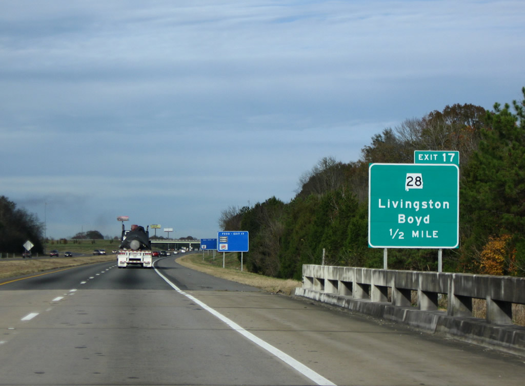
| Northbound I-20/59 spans the Sucarnoochee River a half mile from the diamond interchange (Exit 17) with SR 28 at Livingston. Livingston is home to the University of West Alabama. 11/28/09 |
|
| SR 28 joins U.S. 11 south through the Sumter County seat 1.76 miles from Exit 17. Westward the state route continues 5.90 miles to SR 17 north of Boyd. 11/28/09 |
|
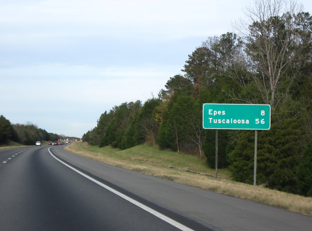
| I-20/59 advances eight miles northeast to Epes and 56 miles to Tuscaloosa. 11/28/09 |
|
| Sumter County Road 20 joins I-20/59 at a diamond interchange (Exit 23) near U.S. 11 and the town of Epes in one mile. 11/28/09 |
|
| County Road 20 leads east from SR 17 through Sumterville and agricultural lands to CR 21 (Cedar Hill Drive) at Epes. 11/28/09 |
|
| Exit 23 parts ways from I-20/59 north for Epes and Gainesville. SR 39, which has no direct connection with the freeway to the southwest, intersects CR 20 nearby on an 11 mile long course between U.S. 11 and Gainesville. 11/28/09 |
|
| CR 21 (Cedar Hill Road) leads north from Epes to Gainesville across I-20 east / I-59 north beyond this set of reassurance markers. 11/28/09 |
|
| Next along I-20 east / I-59 north is the town of Boligee in 11 miles. Tuscaloosa is 49 miles away. 11/28/09 |
|
| The Tenn-Tom Waterway (Tennessee-Tombigbee) system constitutes a 234 mile marine transportation highway linking the Tennessee River in northeastern Mississippi with the Tombigbee River in the Black Belt of Alabama.1 11/28/09 |
|
| Built in 1976, the Sally S. Minus Memorial Bridge on I-20/59 spans the Tombigbee River. 11/28/09 |
|
| Northbound I-20/59 enter Greene County beyond the Tombigbee River. I-20/59 runs 28.26 miles through the county named after Revolutionary War General Nathanael Greene of Rhode Island.2 11/28/09 |
|
| A series of flood relief bridges precede the diamond interchange (Exit 32) with County Road 20 on the north side of Boligee. 11/28/09 |
|
| Exit 32 departs one half mile north of a Gulf Coast Railway under crossing for CR 20. CR 20 orientates roughly southeast to northwest parallel to the Tombigbee River between SR 13 at Forkland and SR 39 at New Mount Hebron. 11/28/09 |
|
| I-20 east / I-59 northbound at County Road 20 and Lizzieville within the town of Boligee. CR 81 branches southwest from CR 20 nearby along Constantine Street to Main Street and U.S. 11 (Boligee Street). 11/28/09 |
|
| Brush Creek parallels the west side of I-20/59 on the 7.97 mile long stretch between Exits 32 and 40. 11/28/09 |
|
| Eutaw, the seat of Greene County, is ten miles to the northeast. Tuscaloosa is 40 miles away. 11/28/09 |
|
| Rest areas line both sides of I-20/59 to the west of Eutaw. The northbound facility precedes the County Road 131 over crossing. 11/28/09 |
|
| One mile southwest of the diamond interchange (Exit 40) with SR 14 in Eutaw. SR 14 is the only crossing of the Black Warrior River between Demopolis and Tuscaloosa. 11/28/09 |
|
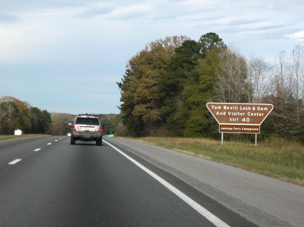
| SR 14 travels northwest 34 miles to Pickensville and Aliceville Lake. The lake was formed by Aliceville Lock and Dam, which bears the name of Tom Bevill, a proponent of the Tenn-Tom Waterway.3 Southeast to the Black Warrior River, amenities for outdoor enthusiasts there include the Jennings Ferry Campground. 11/28/09 |
|
| SR 14 overall measures 218.29 miles in length, starting in western Alabama from Mississippi Highway 69, southeast of Columbus. SR 14 continues southeast through Aliceville and Eutaw, crosses the Black Warrior River, then connects to Greensboro, Marion and Selma. Beyond Selma, SR 14 turns east to serve Prattville, Wetumpka, Tallassee and Auburn-Opelika. 11/28/09 |
|
| SR 14 follows Mesopotamnia Street southeast from Exit 40 to Tuscaloosa street and Downtown Eutaw. Connections with U.S. 43 there lead motorists south to Demopolis. 11/28/09 |
|
| I-20/59 continue northeast from Eutaw through low rolling and forested hills. 11/28/09 |
|
| The town of Union, ten miles to the north via I-20/59 and County Road 208, is the next control point. Tuscaloosa is a half hour away. 11/28/09 |
|
| The forested frontage and light traffic in this scene ahead of the Greene County Route 70 overpass is typical of I-20/59 in western Alabama. ALDOT recorded 23,230 vehicles per day on this stretch in 2010. 11/28/09 |
|
| County Road 203 (M.L. King Highway) crosses paths with I-20/59 at a diamond interchange (Exit 45) in one mile. 11/28/09 |
|
| Exit 45 serves adjacent the Greenetrack Entertainment Center along CR 208 south. Union is a 5.7 mile drive north via the county highway. 11/28/09 |
|
| CR 208 travels overall between CR 156, north of Mantua, and parallel U.S. 11/43 to the south. 11/28/09 |
|
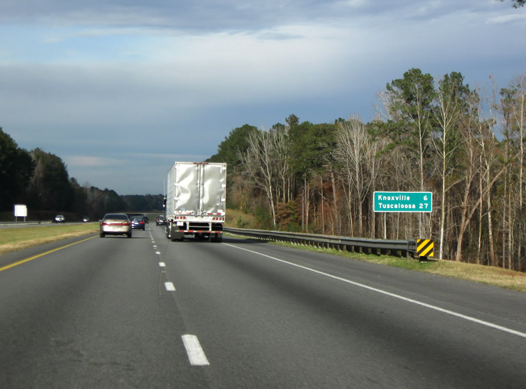
| Knoxville, a settlement at U.S. 11/43 and Greene County Route 220, is the next exit in six miles. Tuscaloosa follows in 27 miles. 11/28/09 |
|
| U.S. 11/43 combine at Downtown Eutaw 12.68 miles to the southwest. The pair converge with I-20/59 at a diamond interchange (Exit 52) by Knoxville. 11/28/09 |
|
| U.S. 11/43 shift to the north side of I-20/59 at Exit 52 en route to their separation in Tuscaloosa. 11/28/09 |
|
| Exit 52 departs for U.S. 11/43 at Knoxville. Greene County Route 220 west from Knoxville leads to Snoddy while U.S. 11/43 continue to Ralph. 11/28/09 |
|
| I-20 east / I-59 north continue 3.11 miles to the Tuscaloosa County line. 11/28/09 |
|
| The roadways of I-20/59 separate on the descent from Knoxville to Buck Creek and the County Road 55 overpass. 11/28/09 |
|
| CR 56 passes over I-20/59 ahead of the Tuscaloosa County line. 11/28/09 |
Page Updated 10-15-2012.


 East
East  North
North