WV 51 runs between Berkeley and Jefferson Counties in the eastern Panhandle. The state route travels southeast from WV 45 to Gerrardstown, Interstate 81 (Exit 5), and Inwood to U.S. 11. A short overlap carries U.S. 11/WV 51 south through Inwood to Middleway Pike. WV 51 resumes an easterly course along the pike 11 miles to U.S. 340 outside of Charles Town.
|
| WV 51 (Gerrardstown Road) eastbound after its diamond interchange with Interstate 81 (Exit 5) at Inwood. A freeway style distance sign lists the distances to Inwood, Charles Town, and Harpers Ferry (via U.S. 340). Interstate 81 northbound travelers should take WV 51 east to Charles Town for U.S. 340. 07/24/04 |
|
| Eastbound reassurance marker posted between Interstate 81 and Pilgrim Street at Inwood. The village center lies to the southeast at the intersection of U.S. 11 & WV 51 (Winchester Avenue) at Middleway Pike & True Apple Way. 07/24/04 |
|
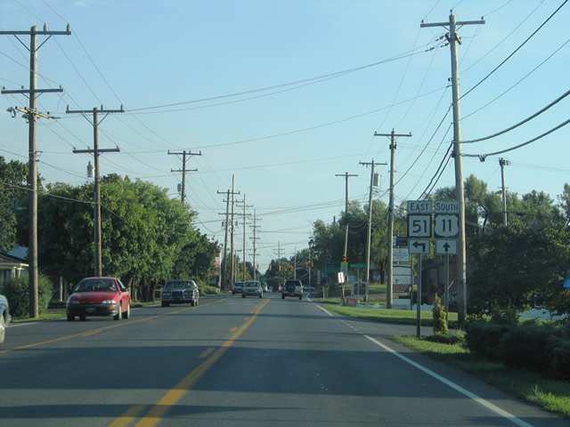
| WV 51 east turns onto U.S. 11 (Winchester Avenue) southbound for a 0.3 mile overlap between Gerrardstown Road and Middleway Pike. U.S. 11 enters Inwood 3.1 miles south of Eastern West Virginia Regional Airport (Shepherd Field). 07/24/04 |
|
| Span-wire supported traffic signals govern the movements between U.S. 11 (Winchester Avenue) and WV 51 (Gerrardstown Road). The two share pavement southward to the Inwood village center to the right. 07/24/04 |
|
| U.S. 11 south & WV 51 east (Winchester Avenue) overlap briefly before splitting at Middleway Pike. True Apple Way (CR 11) ties into the split from the west. U.S. 11 otherwise continues two miles south of Bunker Hill and five miles to the Virginia state line near Ridgeway. 07/24/04 |
|
| The south split of U.S. 11 (Winchester Avenue) from Route 51 (Middleway Pike) east. 07/24/04 |
|
| WV 51 resumes its easterly course along Middleway Pike. Five miles separate Inwood with the village of Middleway. Middleway Pike meanwhile passes through suburbanized communities east from U.S. 11 in Inwood. The West Virginia panhandle grows more and more each year with bedroom communities for Washington, D.C. commuters. 07/24/04 |
|
| WV 51 (Middleway Pike) crosses the Opequon Creek one mile ahead of County Route 1 at Middleway. The waterway represents the Berkeley and Jefferson County line. Charles Town lies seven miles ahead. 07/24/04 |
|
| A two lane pony truss bridge carries WV 51 (Middleway Pike) across the Opequon Creek into Berkeley County. Middleway Pike carries the state highway one mile west to Tarico Heights and four miles west to Inwood. Giles Mill Road spurs west from Tarico Heights three miles to Bunker Hill. 07/24/04 |
|
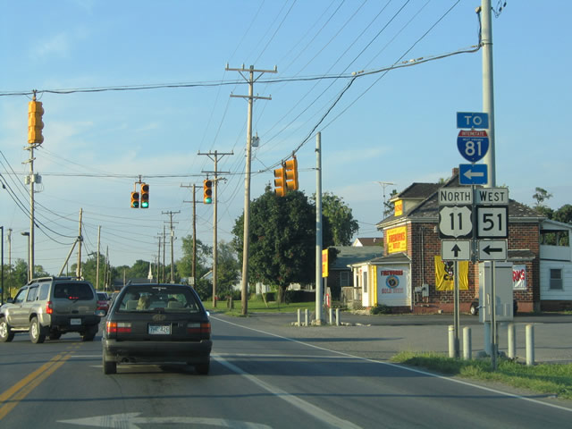
| U.S. 11 north & WV 51 combine between Middleway Pike and Gerrardstown Road in Inwood. The highways split just one half mile east of the diamond interchange joining WV 51 with Interstate 81. U.S. 11 (Winchester Avenue) continues 6.5 miles north to WV 45 (Apple Harvest Drive) at the city of Martinsburg. WV 51 loops 5.2 miles northwest through Gerrardstown to WV 45 as well. 07/24/04 |
Page Updated 03-10-2005.