|
| The Garden State Parkway begins as the Garden State Parkway Extension from I-87/287 (New York Thruway) at Chestnut Ridge, New York. An unnumbered half diamond interchange lies north of the state line at Red Schoolhouse Road. All trucks taking the Extension must depart before the Parkway enters New Jersey. 08/07/04 |
|
| Last exit in New York sign posted ahead of the Red Schoolhouse Road off-ramp at Chestnut Ridge. The short Extension receives its own milepost system with the prefix GS. 08/07/04 |
|
| Drivers bound for Chestnut Ridge, New York depart the Garden State Parkway Extension southbound. School House Road (CR 41) crosses paths with the Parkway midway between Upper Montvale, New Jersey (as Spring Valley Road) and Chestnut Ridge Road. 08/07/04 |
|
| Entering Bergen County, New Jersey along the Garden State Parkway Extension southbound. Milepost 172.3 resides just south of the pavement change. 08/07/04 |
|
| Motorists services are available along the Garden State Parkway in the form of Service Plazas. These facilities are generally not as large as those found on the Turnpike, with some offering just one gas and food vendor. The Montvale facility is the first along encountered along southbound. 08/07/04 |
|
| The Montvale Service Plaza offers a wider array of food choices, a tourist information center, but just one fuel vendor. The plaza lies within the Parkway median south of the Grand Avenue underpasses. 08/07/04 |
|
| Continuing south, motorists next encounter the Pascack Valley main line Toll Plaza. A diagrammatic overhead lies south of the Glen Road (CR 92) half diamond interchange (Exit 171 on northbound) adjacent to the Werimus Road (CR 71) overpass. 08/07/04 |
|
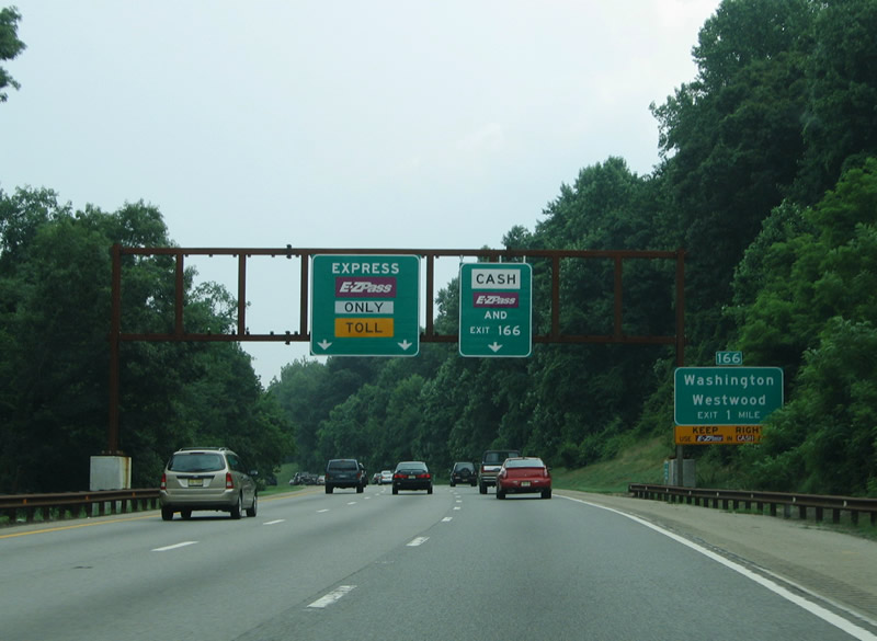
| Exit 166 with Linwood Avenue (CR 110) represents the first departure point of the Garden State Parkway southbound in New Jersey at Washington Township and north Paramus Note the change in guide signs between 2005 and 2007. 06/30/05, 08/04/07 |
|
| A loop ramp joins the Parkway southbound from Washington Avenue (Bergen County 502) in Washington Township. Exit 168 joins the east-west street from northbound, one mile beyond the Pascack Valley Toll Plaza. 08/04/07 |
|
| Nearing the Pascack Valley Toll Plaza on the Garden State Parkway southbound. All cash paying traffic and drivers departing for Exit 166 must use the conventional toll booths on the outside lanes. Open road tolling exists along the inside lanes. Connections with Pascack Road (CR 63) north leads to Bergen County 502 (Washington Avenue), Hillsdale, and Westwood. 08/04/07 |
|
| A third Exit 166 guide sign precedes the Linwood Avenue loop ramp beyond the toll plaza. Linwood Avenue (CR 1101) stems west from parallel Pascack Road (CR 63) to a cloverleaf interchange with Route 17 at the village of Ridgewood. 06/30/05 |
|
| Glen Avenue (CR 82) passes over the Parkway before it enters the Pascack Valley Toll Plaza. A variable message sign was added in place of a static guide sign for the high-speed EZ Pass lanes between 2005 and 2007. 08/04/07 |
|
| Two open road tolling lanes are available to southbound travelers along the GSP at the Pascack Valley Toll Plaza. 08/04/07 |
|
| Exit 166 departs the cash lanes of the toll plaza for Linwood Avenue. Linwood Avenue (CR 110) straddles the Washington Township and Paramus borough line. 06/30/05 |
|
| A cloverleaf interchange joins the Garden State Parkway with Oradell Avenue (CR 80) east, Ridgewood Avenue (CR 80) west and From Road south in north Paramus. Ridgewood Avenue ventures west from the interchange to a cloverleaf interchange with Route 17 near the Fashion Center retail complex. Route 17 leads northwest from there into the village of Ridgewood. From Road comprises a southbound side frontage road to Paramus Park Mall and Midland Avenue. 06/30/05, 08/04/07 |
|
| A collector distributor roadway facilitates the movements to Ridgewood Avenue west and Oradell Avenue east from the Garden State Parkway. Park and ride lots reside within each of the four loop ramps. Oradell Avenue (CR 80) otherwise travels east to the borough of Oradell and Oradell Reservoir. 08/04/07 |
|
| Route 17 and the Garden State Parkway converge at a partial interchange ( Exit 163) in one mile. The six lane arterial travels from Ridgewood southward through west Paramus to Route 4 opposite the Garden State Plaza mall. Exit 163 consists of a left side off-ramp onto Route 17 south. 08/04/07 |
|
| A second diagrammatic overhead lies north of the Midland Avenue underpass on the Parkway south. Route 17 provides the only connection to the Route 4 expressway leading east to I-95/U.S. 1-9-9W-46 at Fort Lee and the George Washington Bridge. 08/04/07 |
|
| Garden State Parkway southbound at the Exit 163 off-ramp onto Route 17 south. Route 17 sees several interchanges along its route through North Jersey, but overall constitutes a heavily developed commercial arterial. South of Route 4, the state route continues into Rochelle Park and Maywood. Route 4 west leads to Fair Lawn and New Jersey 208 north for Glen Rock. 08/04/07 |
|
| Two ramps add traffic from Route 4 west and Paramus Road (CR 62) south, but southbound drivers otherwise continue uninterrupted to Interstate 80 (Exit 159). Interstate 80 begins six miles to the east and meets the Parkway at Saddle Brook. 06/30/05 |
|
| The Garden State Parkway straddles the Saddle River south of the Exit 160 (northbound) half diamond interchange with Passaic Street / Paramus Road (CR 62). Exit 159 meanwhile consists of a two lane off-ramp west of the northbound Saddle Brook main line Toll Plaza. Yellow panels on the Exit 159 overheads were switched between 2005 and 2007 to reduce confusion as the toll plaza does not effect the southbound travel lanes. 06/30/05, 08/04/07 |
|
| Southbound travelers continue without paying a toll by the Saddle Brook Toll Plaza. 08/04/07 |
|
| Exit 159 departs Garden State Parkway southbound onto a parallel distributor roadway for Interstate 80. An access road and trumpet interchange tie the northbound Parkway with I-80 independent of the southbound ramps. 08/04/07 |
|
| Drivers continuing toward Interstate 80 via Exit 159 first encounter a loop ramp to Molnar Drive at Midland Avenue (CR 67). Midland Avenue ventures north into an adjacent industrial area and south to New Pehle Avenue and Passaic Junction. 08/04/07 |
|
| An NJ Transit line passes over the Parkway at the westbound ramp to Interstate 80. Interstate 80 continues a short distance to Paterson. 08/04/07 |
|
| Those remaining on the Exit 159 ramp default onto Interstate 80 eastbound via a loop ramp after the freeway over crossing. Interstate 80 ends at Interstate 95 in Ridgefield Park, five miles west of Fort Lee and the George Washington Bridge into New York City. 08/04/07 |
|
| Continuing south, Parkway travelers next meet U.S. 46 at Elmwood Park (Exit 157). New Jersey 20 constitutes a 4.15 mile route north along the Passaic River from U.S. 46 at Clifton to CR 504 in north Patterson. 06/30/05 |
|
| Intrastate U.S. 46 shadows Interstate 80 throughout its North Jersey routing. Locally the divided highway serves Garfield and Lodi to the east and Clifton to the west. U.S. 46 and New Jersey 20 interchange nearby, with U.S. 46 meeting the Parkway again at Exit 156 (northbound). Travelers bound for the New Jersey 21 freeway south to Passaic and Rutherford should take U.S. 46 west as there is no connection again until Exit 155. 08/04/07 |
|
| Crossing the Passaic River between River Drive (Bergen County 507) and U.S. 46. The river represents the Passaic County line and Clifton city limits. 08/04/07 |
|
| Looking northward at the adjacent U.S. 46 crossing of the Passaic River. The south end of New Jersey 20 lies at the west end of the bridge. 08/04/07 |
|
| The next southbound interchange joins the Parkway with U.S. 46 west at the south end of the Route 19 freeway (Exit 155). U.S. 46 travels west from Clifton to Little Falls and West Paterson. 08/04/07 |
|
| A half diamond interchange (Exit 155 on northbound) adds traffic from Hazel Street (CR 702). Exit 155 otherwise departs the GSP south beyond the NJ Transit Main Line under crossing for U.S. 46 west adjacent to Grove Street (CR 623) in Clifton. 08/04/07, 06/30/05 |
|
| The Garden State Parkway turns southward again at the merge with Route 19 freeway south. Route 19 joins northbound with Interstate 80 and Downtown Paterson.
U.S. 46 leaves the Parkway corridor and merges with the north end of Route 3 in west Clifton nearby. 08/04/07 |
|
| A wye interchange constitutes the south end of Route 19 (northbound Exit 154) with the Garden State Parkway. Additional ramps tie in from U.S. 46 to the south at Exit 154. 08/04/07 |
|
| Passing under U.S. 46 and a high flyover from the US highway east onto the Parkway northbound. 08/04/07 |
|
| Southbound motorists next meet the Route 3 expressway southward to Passaic, East Rutherford, and Secaucus. 08/04/07 |
|
| Exit 153 consists of a left side off-ramp to Route 3 south from the Garden State Parkway south. Route 3 continues from its beginning at U.S. 46 in west Clifton through Passaic to New Jersey 21 at Nutley. Interests to the Meadowlands Sports Complex, home of the New York Giants and Jets football teams, should remain on Route 3 to East Rutherford. 08/04/07 |
|
| Allwood Road (CR 602) and Route 3 pass over the Parkway southbound before Exit 153 departs. Route 3 comprises a full freeway from Clifton southeast to Route 495 and U.S. 1/9 at North Bergen township. Route 495 stems east from Interstate 95 (New Jersey Turnpike) to Weehawken, Union City, and the Lincoln Tunnel to Midtown Manhattan. 08/04/07 |
|
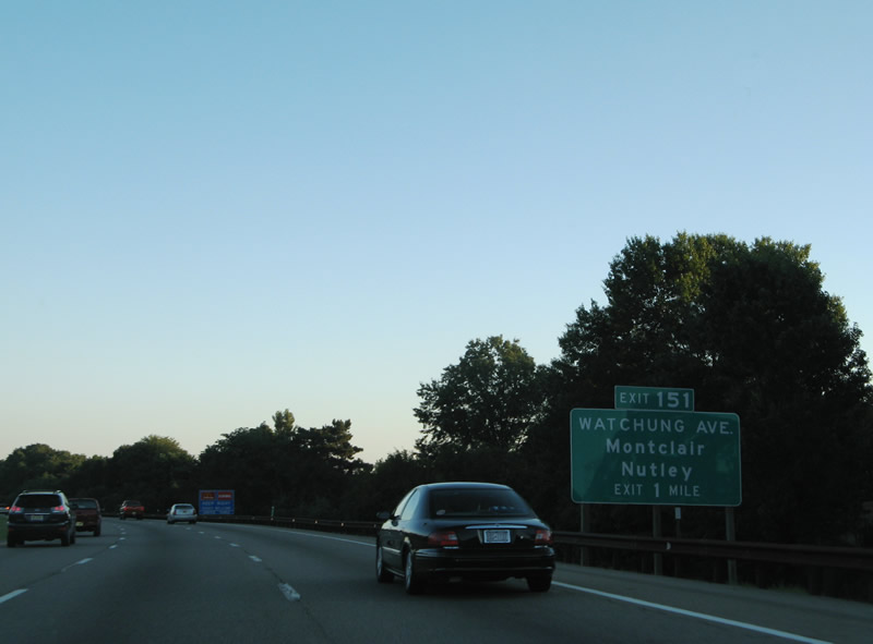
| A diamond interchange (Exit 151) joins the Garden State Parkway with Watchung Avenue (CR 655) in south Passaic. 08/04/07 |
|
| Southbound at the Brookdale South Service Plaza near Broad Street (CR 509) and Passaic Avenue (CR 622) at Brookdale in Bloomfield township. 08/04/07 |
|
| Exit 151 leaves Garden State Parkway southbound for Watchung Avenue. Watchung Avenue (CR 655) west leads to Montclair and east to Nutley via Passaic Avenue south and Centre Street (CR 648) east. 06/30/05 |
|
| A two lane toll plaza is quickly encountered for motorists departing the Parkway at Exit 151. 08/04/07 |
|
| Drivers continues to the Essex main line Toll Plaza beyond the Hoover Avenue underpass (CR 651) in north Bloomfield. Ramps connect Hoover Avenue with the Parkway at Exit 150 (northbound). 08/04/07 |
|
| Open road tolling is not available at the Essex Toll Plaza. Instead E-ZPass account holders must use the left toll lanes at a slower speed (15 mph). 08/04/07 |
|
| Exit 149 joins the Parkway southbound with Belleville Avenue (Essex County 506) in Bloomfield. CR 506 travels east to Belleville and west to Glen Ridge. 08/04/07 |
|
| Southbound at the Exit 149 ramp departure to Kennedy Drive north to Essex County 506. A 10.43 mile route, CR 506 leads east to Route 7 (Washington Avenue) in Belleville township and west Route 159 in Fairfield township. CR 652 follows Kennedy Drive north to Foley Field. 06/30/05 |
|
| A short distance further south is the split diamond interchange (Exit 148) with Essex County Spur 506 (Bloomfield Avenue). Spur 506 continues Bloomfield Avenue south from CR 506 (Belleville Avenue) into north Newark through the Upper Roseville and Seventh Avenue neighborhoods. 08/04/07 |
|
| Exit 148 departs Garden State Parkway southbound for Essex County Spur 506 (Bloomfield Avenue) in Bloomfield Township. A pair of frontage roads (John F. Kennedy Drive) carry drivers to and from Bloomfield Avenue; Bloomfield Avenue comprises a north-south commercial route northward to Glen Ridge and Bloomfield College and south to Essex County 509 (Grove Street). 08/04/07 |
|
| A toll plaza brings the John F. Kennedy Drive southbound on-ramp from Exit 148 onto the Garden State Parkway one mile north of Exit 147 with Springdale Avenue. Upon entering the city of East Orange, JFK Drive changes names into Clinton Street (south) and Walnut Street (north). Exit 147 consists of a half diamond interchange with the frontage roads north of Springdale Avenue. 08/04/07 |
|
| One quarter mile north of the Exit 147 off-ramp to Springdale Avenue via Clinton Street south. Springdale Avenue represents a residential through route east to Lower Roseville in Newark and west to Upsala in East Orange. 08/04/07 |
|
| Continuing south, Parkway drivers next meet Interstate 280 and Essex County 508 (Central Avenue) in East Orange at Exit 145. Interstate 280 joins East Orange with Orange and Newark nearby while CR 508 does the same as a surface arterial. 08/04/07 |
|
| Motorists bound for the Downtown Newark points of interest including The Performing Arts Center, Ironbound and University Heights are advised to use Interstate 280 east from Exit 145. Downtown Newark is also accessible however from Interstate 78 east to New Jersey 21 north (Exit 57). 06/30/05 |
|
| The Garden State Parkway transitions into an urban expressway through East Orange, west Newark, and Irvington. 08/04/07 |
|
| Sinking below grade, Parkway travelers pass under William Street on the one-quarter mile approach to Exit 145 (Interstate 280 and Essex County 508 [Central Avenue]). 08/04/07 |
|
| A single lane ramp departs Garden State Parkway southbound for Exit 145. Interstate 280 overall joins the Parkway with Interstate 95 (New Jersey Turnpike) at Kearny and Interstate 80 near Parsippany. Downtown Newark lies three miles eastward; central Orange is at the next westbound exit. 08/04/07 |
|
| A tri-level stack interchange joins the Garden State Parkway with a short access road to Interstate 280. A second ramp splits from the stack and merges onto the southbound frontage street (Oraton Parkway) ahead of Essex County 508 (Central Avenue). Central Avenue carries the county route westward to City of Orange Township and eastward to the Newark central business district. 08/04/07 |
Page Updated 04-29-2014.

 South - New York