|
| U.S. 41/150 approaches the intersection with SR 246, a 37.7 mile highway that stretches from the town of Prairie Creek, 5.8 miles to the west to Clay City, 16 miles to the east. 10/16/12 |
|
| North of the intersection with SR 246, U.S. 41/150 is now 11 miles away from Interstate 70 and 14 miles away from Downtown Terre Haute. 10/16/12 |
|
| U.S. 41/150 continues their push northward from SR 246 as they get closer to the Terre Haute metro area. 10/16/12 |
|
| Pimento Circle leads east from U.S. 41/150 and Hook Road to the community of Pimento a short distance to the east. 10/16/12 |
|
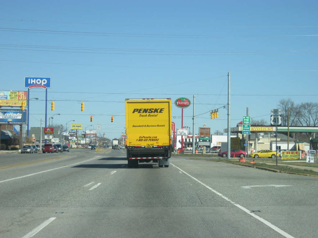
| U.S. 41/150 crosses Harlan Drive and a railroad spur as the highway passes by an industrial park on the far south side of the Terre Haute area. From this point northward, the highway will begin to take a suburban feel as it gets closer to the urbanized part of Terre Haute. 10/16/12 |
|
| U.S. 41/150 approaches the interchange with the new SR 641 highway, a planned 6.2 mile freeway that will connect U.S. 41/150 with Interstate 70, bypassing the upcoming suburban sprawl of Terre Haute along the US route. Eventually, a full bypass of U.S. 41 may be built that will utilize SR 641, U.S. 40 & SR 46 on the east side of Terre Haute and a new terrain segment that would loop around Terre Haute's north side to connect with U.S. 41 and the SR 63 expressway. Currently however there are no concrete plans on such a bypass beyond SR 641. 10/16/12 |
|
| SR 641 currently goes only for two miles north to a folded diamond interchange with McDaniel Road, hence the current control point of McDaniel Road. The entire freeway is expected to be finished by 2014, enabling motorists bound for Interstate 70 east toward Indianapolis a way to bypass the congested segment of U.S. 41/150 to the south of Interstate 70. 10/16/12 |
|
| A ramp takes traffic off of U.S. 41/150 north and onto SR 641 for its short freeway to McDaniel Road. Using McDaniel Road, motorists can currently use a variety of county roads to get back to Interstate 70 via the U.S. 40 east & SR 46 interchange. 10/16/12 |
|
| Reassurance shields for U.S. 41/150 north of the SR 641 interchange. Up ahead is the intersection with Jessica Drive, leading west to the Ivy Tech Community College campus that serves the Terre Haute area. 10/16/12 |
|
| North of the SR 641 interchange, U.S. 41/150 enter Honey Creek Township, which contains the majority of the suburban growth out of Terre Haute. The divided highway slowly transitions from a rural expressway to a suburban arterial landscape as the US highway pair heads north toward 7th Street. 10/16/12 |
|
| 7th Street turns off of U.S. 41/150 at the beginning of the retail strip along the highway that will stretch to the I-70/U.S. 40 interchange. 7th Street represents the original routing of U.S. 41 through Terre Haute with its intersection with Wabash Avenue (old U.S. 40) called the original "Crossroads of America." That means that U.S. 41's path along 3rd Street through Terre Haute is actually the bypass of the original U.S. 41, despite going town itself. 10/16/12 |
|
| This stretch contains lots of businesses and restaurants that serve the Terre Haute and larger Wabash Valley area. For traffic bound for Chicago via SR 63 and U.S. 41 north of Terre Haute, this city represents the most variety of motorist services until the Chicago area. 10/16/12 |
|
| A sign welcomes travelers into the city of Terre Haute (60,785). Terre Haute is the county seat of Vigo County and the cultural and service hub for the Wabash Valley area as well as the home to Indiana State University. Terre Haute is Indiana's 12th largest city by population. 10/16/12 |
|
| More retail businesses abut U.S. 41/150 as the highway gets closer to the interchange with Interstate 70. Note the state-named Interstate 70 shield in the first picture. 10/16/12 |
|
| Intersecting Davis Avenue and the entrance to Honey Creek Mall, the main shopping center for the Wabash Valley region, a multi-county area that spans the Indiana and Illinois state line that is centered around Terre Haute. Heavy traffic is common along this stretch of highway near the forthcoming Interstate 70 interchange. It is because of this that the SR 641 bypass is being constructed. 10/16/12 |
|
| U.S. 41/150 expands to six lanes as the highway approaches the interchange with I-70/U.S. 40. Interstate 70 goes for 2,153 miles from Fort Cove, Utah to Baltimore, Maryland. In Indiana, the interstate travels for 156.6 miles for Terre Haute east to Indianapolis and Richmond. 10/16/12 |
|
| U.S. 40 traveled through Terre Haute via the National Road and Wabash Avenue corridors, but was rerouted to follow the Interstate 70 path from Exit 154 in Illinois eastward to Exit 11 at SR 46 in 2011. In Indiana, U.S. 40 travels the path of the historic National Road for 150 miles, with the exception of interstate multiplexes around Terre Haute and Indianapolis. Nationally, the highway goes for 2,285 miles from Park City, Utah to Atlantic City, New Jersey. 10/16/12 |
|
| It's an hour drive east from U.S. 41/150 to the Indiana capital of Indianapolis via Interstate 70 east. 10/16/12 |
|
| A three hour drive awaits motorists turning westward onto Interstate 70 to St. Louis, Missouri via Marshall and Effingham in southern Illinois. 10/16/12 |
|
| North of the Interstate 70 interchange, U.S. 41/150 enters the urbanized part of the city of Terre Haute. In Terre Haute, U.S. 41/150 is known as 3rd Street and becomes a busy thoroughfare across the municipality. 01/03/10 |
|
| U.S. 41/150 (3rd Street) is a busy arterial highway as it heads north across the south side of Terre Haute. Unlike U.S. 41's transit across Evansville, there is no bypass of the highway in Terre Haute and traffic has to go through the city. 01/03/10 |
|
| U.S. 41/150 (3rd Street) crosses two railroad tracks in the span of three block to the south of the intersection with Voorhees Street. Terre Haute is known locally for its several railroad crossings along major streets, a result of Terre Haute's status as a crossroads for the railroad network. Along with the railroad crossings, multiple street intersections and businesses add onto the busyness of this highway. 01/03/10 |
|
| U.S. 41/150 (3rd Street) meets up with the intersection with Hulman Street, named for the famous Hulman family of Indianapolis Motor Speedway fame. Until 2008, SR 63 followed Hulman Street to the west for two blocks to Prairieton Road as it followed that road to the southwest out of Terre Haute. At this intersection, SR 63 joined U.S. 41/150 for a multiplex that continued to the north side of town. 01/03/10 |
|
| The Vigo County Courthouse comes into view as U.S. 41/150 (3rd Street) continue northward from the Hulman Street. The highway is now six lanes wide at this point, due in part to the previous multiplex with U.S. 41/SR 63. 01/03/10 |
|
| Nearing the Farrington Street intersection, which connects U.S. 41/150 (3rd Street) with Fairbanks Park a few blocks to the west along the Wabash River. 01/03/10 |
|
| The Vigo County Courthouse towers over an otherwise commercial stretch along U.S. 41/150 (3rd Street). U.S. 41/150 actually passes just to the west of the Terre Haute central business district. When traveling U.S. 41 across Terre Haute, one has to remember that it is actually a bypass of the original U.S. 41 that was located four blocks to the east along 7th Street. 01/03/10 |
|
| U.S. 41/150 (3rd Street) approaches the intersection with Popular Street. At one time, SR 42 followed Popular Street from this point eastward as a part of its journey toward Cloverdale and Mooresville. Today, the highway ends at U.S. 40 & SR 46 on the far east side of Terre Haute. 01/03/10 |
|
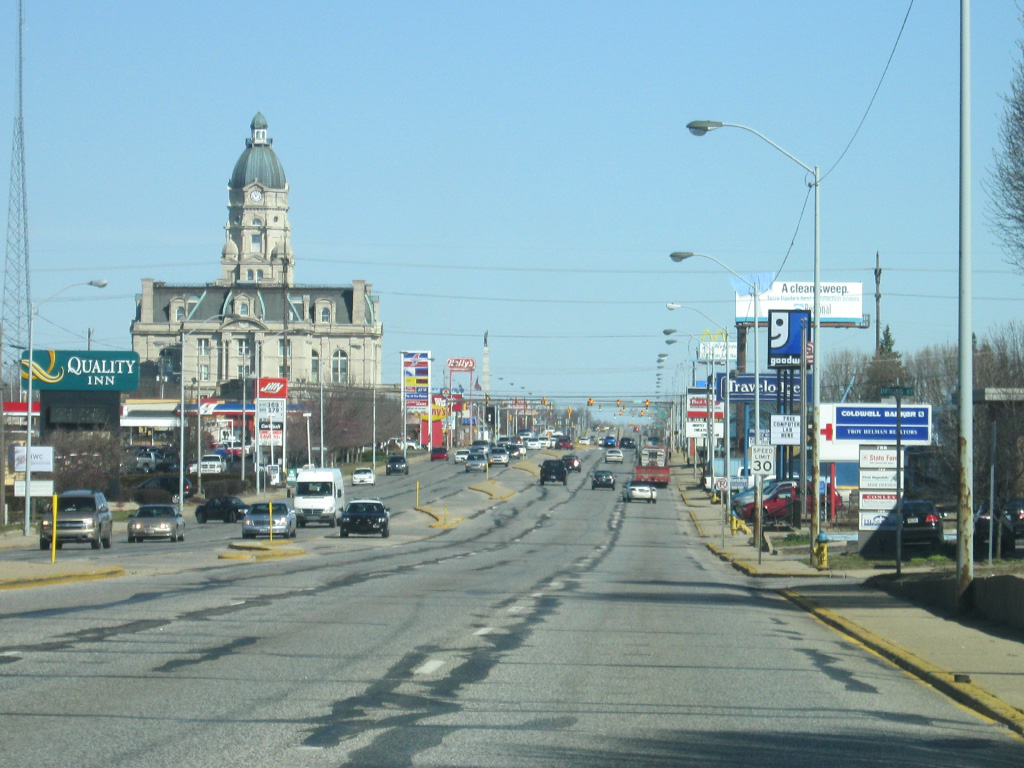
| U.S. 41/150 crosses Walnut Street as the six lane highway enters Downtown Terre Haute. One block to the north at the intersection of 3rd Street and Ohio Street is the Vigo County Courthouse. Located in a prominent spot on the west side of Downtown Terre Haute, the courthouse is Vigo County's second and was finished in 1888. 01/03/10 |
|
| Now at the intersection with U.S. 41/150 (3rd Street) and Ohio Street, a one way street that goes eastbound. Until January 2011, U.S. 40's eastbound lanes followed Ohio Street as a part of a one way couplet with Ohio Street and Cherry Street two blocks to the north. U.S. 150 south joins U.S. 41 at this intersection for its southward journey to Vincennes. 01/03/10 |
|
| The next stoplight intersection along U.S. 41/150 (3rd Street) is with Wabash Avenue, the original National Road and U.S. 40. The National Road Historic Route follows Wabash Avenue to the east through the heart of Downtown Terre Haute and then continues across the city to the junction with SR 46, where Wabash Avenue rejoins U.S. 40 on the far east side of town. A sign on the traffic signal mast directs traffic toward Indiana State University to continue north on 3rd Street. 01/03/10 |
|
| After nearly 60 miles, U.S. 150 finally leaves U.S. 41 at the intersection of 3rd Street and Cherry Street. Cherry Street is a one way street going west that complements Ohio Street to the south, and like Ohio Street, used to carry U.S. 40 along its routing across Downtown Terre Haute. U.S. 150 heads west along Cherry Street across the Wabash River to the town of West Terre Haute two miles away. From Terre Haute, the highway travels in a northwest path across rural Vigo County en route to Paris, Illinois. 01/03/10 |
|
| The next stoplight intersection with U.S. 41 (3rd Street) is with Chestnut Street, which provides the best route to Indiana State University, a sprawling college campus that lies on the north side of Downtown Terre Haute. Best known as the home to the Sycamores and Alma Marta to Larry Bird, Indiana State is the largest of the three colleges based in Vigo County and adds to the culture of Terre Haute. 01/03/10 |
|
| North of the Indiana State University campus, U.S. 41 (3rd Street) rises for an overpass over a pair of CSX railroad tracks. Said overpass is named for Detective Clarence Thompson, a Terre Haute police officer who died in the line of duty on March 8, 1964. 01/03/10 |
|
| On the other side of the overpass above the CSX railroad tracks, U.S. 41 (3rd Street) has an intersection with Locust Street, a major east-west street across Terre Haute's north side. 01/03/10 |
|
| U.S. 41 (3rd Street) remains six lanes as it heads across the north side of Terre Haute, passing by the Riverside Industrial District. 01/03/10 |
|
| The next major intersection along U.S. 41 (3rd Street) is with 8th Avenue, which leads east to Union Hospital, four blocks east of U.S. 41 (3rd Street). 01/03/10 |
|
| North of 8th Avenue, U.S. 41 (3rd Street) nears the southern terminus to the northern segment of SR 63. Until 2008, the state highway went for 96 miles from Merom in Sullivan County north through Terre Haute and beyond to Clinton and past Covington in Fountain County. In 2008, the segment from SR 246 in southwestern Vigo County to Terre Haute was decommissioned. 01/03/10 |
|
| SR 63 is a four lane expressway that goes for 61 miles from Terre Haute north to the town of Clinton and across Vermillion and Warren Counties before meeting back up with U.S. 41 near Carbondale. SR 63 takes over the four lane nature of the expressway from Evansville north to Northwest Indiana and replaces U.S. 41 for this stretch as a long-haul highway across Western Indiana. 01/03/10 |
|
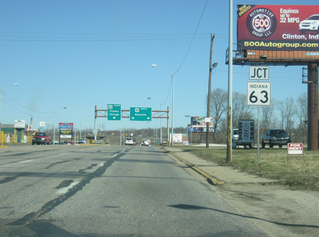
| SR 63 north turns off of U.S. 41 at a split interchange on Terre Haute's north side. The Vermillion County city of Clinton is twelve miles away while Chicago is 175 miles away. U.S. 41 will follow a path across northern Vigo, Parke, Fountain and Warren Counties that mostly consists of a two lane highway, creating the need for the SR 63 expressway in the 1970s. Before the expressway was constructed, SR 63 continued along the path with U.S. 41 (then Lafayette Avenue and Clinton Street) and followed the highway north to the present-day junction with U.S. 41 and SR 163 east of Clinton. 01/03/10 |
|
| Northeast of the interchange with SR 63 north, U.S. 41 continues as a four lane expressway across Terre Haute's north side. SR 63 heads for the western side of the Wabash River while U.S. 41 stays to the east of the river. 01/03/10 |
|
| The final stoplight for U.S. 41 traffic in Terre Haute is with Fort Harrison Road, named for Fort William Henry Harrison, which was located along the Wabash River to the west of this intersection. 01/03/10 |
|
| North of the Fort Harrison Road intersection, the Vermillion County community of Clinton is 12 miles away via U.S. 41 and SR 163. The Parke County seat of Rockville is 22 miles away. 01/03/10 |
|
| U.S. 41 resembles a rural four lane expressway as it bypasses the community of North Terre Haute. 01/03/10 |
|
| Just north of the community of North Terre Haute, U.S. 41 prepares to be reduced to two lanes as it nears the Clinton Street entrance ramp. 01/03/10 |
|
| U.S. 41 passes underneath the ramp from southbound U.S. 41 to Clinton Street, which heads south through the community of North Terre Haute along the original routing of U.S. 41. 01/03/10 |
|
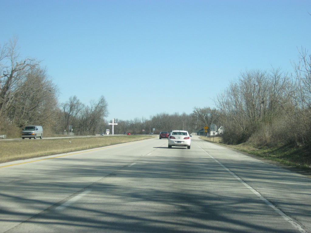
| U.S. 41, now a two lane highway, continues in a northerly direction toward the community of Clinton and the Vigo-Parke County line. 01/03/10 |
|
| At 117th Avenue/Lambert Avenue, U.S. 41 enters Parke County (population 17,339). Parke County is best known as the Covered Bridge Capital of the World, with 31 covered bridges located throughout the county and the famous Covered Bridge Festival that is held every October. 117th Avenue/Lambert Avenue heads east from U.S. 41 to Coxville Road, which heads north to the town of Rosedale. 01/03/10 |
Page Updated 04-24-2013.

 North
North  West
West