|
| Florida welcome monuments were erected at the entrances to the state along I-10 east, I-75 south and I-95 south in 2016. 05/15/16 |
|
| A former rest area near the state line was converted into a Florida Agricultural Inspection Station in 2006. All trucks, commercial and rentals, must enter the facility. 05/15/16 |
|
| Projects under study along I-10 include widening the freeway to six lanes from the state line east to a new diamond interchange with Beulah Road (SR 99), and expanding Beulah Road to a four lane arterial south to U.S. 90 Alternate (Nine Mile Road). 05/15/16 |
|
| A set of weigh stations opened along Interstate 10 in November 2003 ahead of the Florida Welcome Center. 05/15/16 |
|
| Advancing southeast to the Florida Welcome Center, suburban development increases along Interstate 10. 05/15/16 |
|
| The tourist information center and rest area along I-10 eastbound lies just west of Eleven Mile Creek. 05/15/16 |
|
| U.S. 90 Alternate (Nine Mile Road) converges with Interstate 10 at a diamond interchange (Exit 5) between the Navy Federal Credit Union corporate campus and the community of Pine Forest. 05/15/16 |
|
| U.S. 90 Alternate (Nine Mile Road) branches east from U.S. 90 in a rural area of Beulah four miles to the west. Expanding into a commercial arterial, Nine Mile Road extends east to Ensley and the University of West Florida (UWF). 05/15/16 |
|
| Construction underway through Summer 2021 expands the remaining two mile section of U.S. 90 ALT (Nine Mile Road) leading 5.8 miles west of SR 297 (Pine Forest Road). Suburban growth transitioned Nine Mile Road from a rural highway starting with the addition of a signal at SR 99 (Beulah Road) in 2009. 04/25/10 |
|
| Interstate 10 continues one mile southeast to a parclo interchange (Exits 7A/B) with SR 297 (Pine Forest Road). SR 297 constitutes a 4.29 mile arterial between U.S. 90 Alternate at Pine Forest and U.S. 90 at Bellview. 05/15/16 |
|
| Five Flags Speedway lies 1.25 miles south of Exit 7A along SR 297 (Pine Forest Road). Perdido Key. The south end of SR 297 ties into U.S. 90 (Mobile Highway) at the Pensacola Interstate Fairgrounds. 05/15/16 |
|
| SR 297 (Pine Forest Road) south to SR 173 (Blue Angel Parkway) provides the most direct route from I-10 to Perdido Key via SR 292. SR 173 runs 11.93 miles south to CR 292A (Gulf Beach Highway) and the west gate to the Pensacola N.A.S. 05/15/16 |
|
| SR 297 (Pine Forest Road) north transitions into CR 297 at U.S. 90 Alternate and the community of Pine Forest. CR 297 extends 3.37 miles north and east to U.S. 29 at Gonzalez. 05/15/16 |
|
| Road work (Project Number 222476-1) funded for Fiscal Year 2023 widens Interstate 10 to six lanes east through the exchange with U.S. 29. 05/15/16 |
|
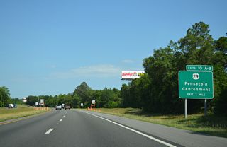
| A directional cloverleaf interchange (Exits 10A/B) joins I-10 with U.S. 29 next. U.S. 29 (Pensacola Boulevard) meets the freeway amid heavy commercial development ranging from an auto mall to big box retail. 05/15/16 |
|
| The roadways of I-10 diverge to accommodate left side ramps from U.S. 29. Exit 10A departs at the BNSF Railroad underpass for Pensacola Boulevard south toward Brent and Palafox Street in Pensacola. U.S. 29 ends at U.S. 90/98 (Cerventes Street) in the historic district of the city. 05/15/16 |
|
| Interchange improvements at I-10 and U.S. 29 will eliminate the loop ramp (Exit 10B) to Pensacola Boulevard northbound, construct new roadways for I-10 through the exchange, and repurpose the old roadways as entrance ramps from U.S. 29. 05/15/16 |
|
| $48.9 million in construction through Summer 2021 widens 2.63 miles of U.S. 29 (Pensacola Boulevard) to six overall lanes from I-10 to U.S. 90 Alternate (Nine Mile Road) at Ensley. U.S. 29 passes through Gonzalez and Cantonment en route to Century and Flomaton, Alabama. 05/15/16 |
|
| Costing $8.5 million, I-10 / U.S. 29 Interchange Improvements Phase I removed the loop ramp from I-10 west to U.S. 29 south and widened the eastbound span over Pensacola Boulevard, eliminating the lane drop from the left entrance ramp. Work was completed in October 2018.1 05/15/16 |
|
| The I-10 roadways reconvene at the Palafox Street (CR 95A) and CSX Railroad overpasses. 05/15/16 |
|
| Completed by August 2008, the Interstate 10-110 interchange project widened I-10 between U.S. 29 (Exit 10) and SR 291 (Exit 13) to six overall lanes. 05/15/16 |
|
| Improving traffic flow and eliminating weaving traffic, 2002-08 construction at the trumpet interchange joining I-10/110 added two flyovers and c/d roadways between I-110 south (Exit 13) and SR 291 (Exit 12). 05/15/16 |
|
| Linking I-10 with Downtown Pensacola and Gulf Breeze / Pensacola Beach via U.S. 98 across the Pensacola Bay Bridge, Interstate 110 spurs 6.94 miles south to U.S. 98 Business (Chase / Garden Streets). 05/15/16 |
|
| Exit 12 departs for Interstate 110 south to Brent, Pensacola and the Emerald Coast. The last of the five I-110's designated across the country, I-110 opened south to Maxwell Street (Exit 3) in 1969 and was completed in 1978. 05/15/16 |
|
| SR 291 (Davis Highway) parallels I-110 to the east along a heavily developed commercial arterial between University Town Plaza and West Florida Hospital. 05/15/16 |
|
| The original overpasses linking I-10 and I-110 were refurbished and repainted during the 2003-08 construction project. 05/15/16 |
|
| Honoring the Blue Angels flight demonstration squadron based out of the Pensacola Naval Air Station, bridge supports at the exchange with I-110 are decorated with miniature Blue Angel replicas. 05/15/16 |
|
| The c/d roadway extends east from I-110 into the parclo interchange (Exit 13) with SR 291 (Davis Highway). 11/19/15 |
|
| An 8.67 mile route, SR 291 runs south to U.S. 98 Business (Gregory Street) outside Downtown Pensacola and northeast to U.S. 90 Alternate (Nine Mile Road). University Parkway branches north from Davis Highway at Ferry Pass nearby en route to UWF. 11/19/15 |
|
| Six lane expansion along I-10 east from SR 291 to U.S. 90 (Scenic Highway) commenced in 2013. Anticipated for completion in Fall 2016,2 construction including the addition of sound walls and realignment of the ramps at Exit 17, ran through January 2018.3 The speed limit increases to 70 MPH and remains at 70 to Tallahassee. 08/01/08 |
|
| I-10 advances east from the SR 289 (Ninth Avenue) overpass, where planners endorsed a proposed interchange on February 20, 1970,4 to Exit 17 for U.S. 90 (Scenic Highway). U.S. 90 straddles Escambia Bay south into Pensacola and north toward the community of Pace. 05/16/04 |
|
| The folded diamond interchange at Exit 17 lies opposite a CSX Railroad line and Escambia Bay. Scenic Highway is named for the bluffs lining Escambia and Pensacola Bays along U.S. 90. U.S. 90 was designated a Florida Scenic Byway between Cerventes Street and the Escambia River in 1999. 05/16/04 |
|
| Continuing northeast from U.S. 90, Interstate 10 crosses Escambia Bay into Santa Rosa County. Fed by the Escambia River, Escambia Bay opens southward into Pensacola Bay and Santa Rosa Sound. The county line sign was installed in 2012. 03/20/12 |
|
| The Escambia Bay bridges replaced twin two lane spans damaged by Hurricane Ivan in September 2004. A wide shoulder beyond Exit 17 remains from the temporary configuration when the eastbound span carried both directions of I-10 while the westbound bridge was built. 08/03/11 |
|
| Sometimes referred to as the "Crooked Bridge", Interstate 10 straightens out ahead of the bridge hump across the Escambia Bay channel. The bridge orientation was because the new spans tied into the footprint of the original crossing during construction. 08/03/11 |
Page Updated 11-23-2020.

 East
East


