|
| Signed as Airport Boulevard, Exit 129 to Messer Airport Highway lies just west of the 3rd Avenue N underpass and trumpet interchange joining I-59/20. 05/06/22 |
|
| The next three exits serve residential areas northeast of Downtown Birmingham including Woodlawn, Kingston, East Birmingham and Norwood. 05/06/22 |
|
| Messer Airport Highway heads north from the parclo interchange at Exit 129 to the passenger terminal at Birmingham-Shuttlesworth International Airport (BHM). The five lane boulevard extends southwest from I-59/20 through industrial areas to 5th Avenue N and Downtown. 05/06/22 |
|
| Forthcoming Exit 128 serves the Vanderbilt and Inglenook neighborhoods north of I-20/59 and East Birmingham to the south. The exchange marks the south end of SR 79 (Tallapoosa Street). 05/06/22 |
|
| Removed by 2018 when a DMS was installed, the first reassurance shields for the 153 mile long overlap along I-59/20 preceded Exit 128. 10/08/16 |
|
| Two lanes depart from I-20/59 west for SR 79 north toward Tarrant City and 40th Street south. SR 79 travels 117.61 miles overall between Birmingham and the Tennessee state line north of Hytop. 05/06/22 |
|
| SR 79 originally followed Vanderbilt Road southwest from Tallapoosa Street to 12th Avenue N. The route ended at U.S. 31 (26th Street N). 09/27/03 |
|
| I-20/59 curve southwest one mile ahead of the diamond interchange (Exit 126 B) with 31st Street N. 05/06/22 |
|
| I-20/59 span Norfolk Southern and CSX Railroads at East Birmingham, a half mile ahead of Exit 126 B. Confirming markers were posted here until 2020. 05/06/22 |
|
| U.S. 31/280 (Elton B. Stephens Expressway) meet I-20/59 at a directional T interchange (Exit 126 A) above 26th Street N / Carraway Boulevard in one mile. 05/06/22 |
|
| Exit 126 B to 31st Street N serves interests to Sloss Furnaces National Historic Landmark. Parallel Richard Arrington, Jr. Boulevard and 12th Avenue N both lead west to the Birmingham-Jefferson Convention Complex (BJCC). 05/06/22 |
|
| Exit 126 B departs I-20/59 south for 31st Street at the Norwood community and 25th Street N at Richard Arrington, Jr. Boulevard. The University of Alabama at Birmingham (UAB) is located west off of U.S. 31/280 along University Boulevard (old SR 149). 05/06/22 |
|
| The ramp from Exit 126 B to 25th Street N by Protective Stadium replaced what was Left Exit 125 to 22nd Street N. 05/06/22 |
|
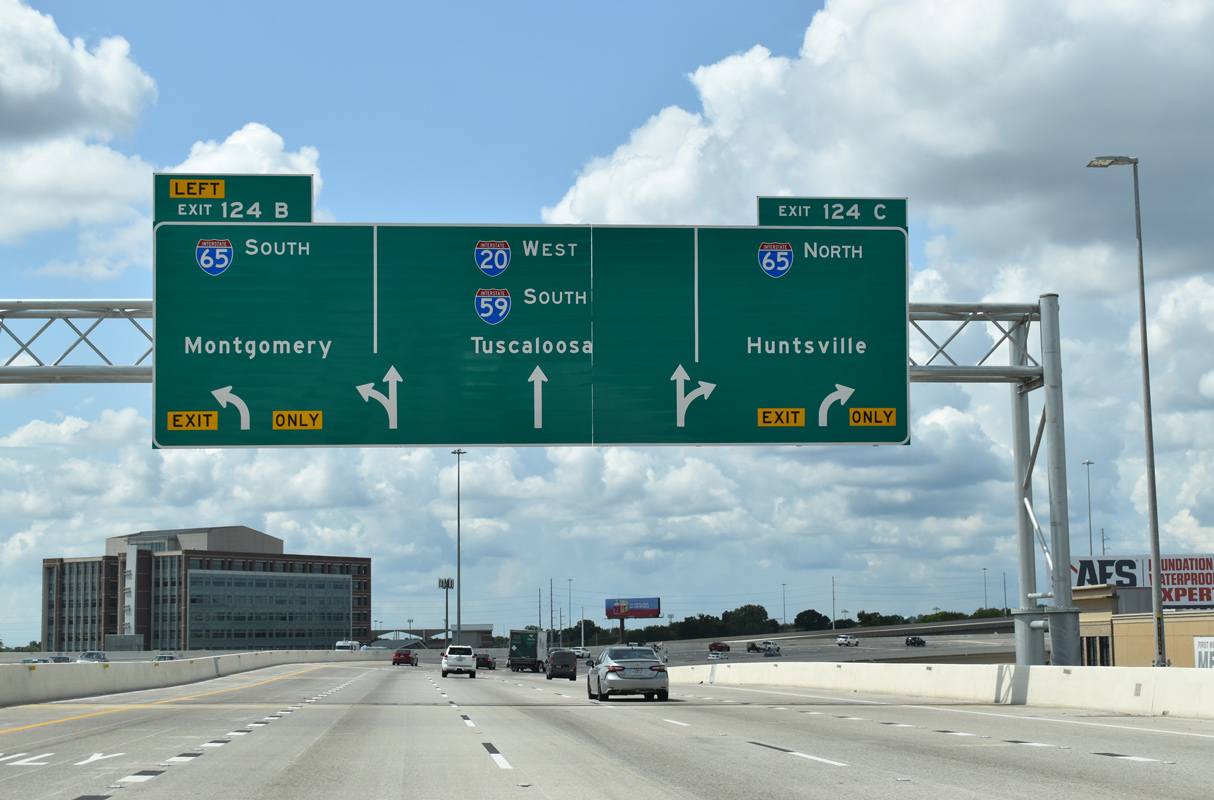
| I-20/59 advance 1.75 miles west by Downtown Birmingham to the systems interchange (Exits 124 C/B) with Interstate 65. Overlapping with U.S. 31 south along Elton B. Stephens Expressway to Red Mountain and the city of Homewood, U.S. 280 east begins at Exit 126 A. 05/06/22 |
|
| Exit 126A partitions into flyovers for both U.S. 31/280 (Elton B. Stephens Expressway) south and 26th Street N at 6th Avenue to Carraway Boulevard. U.S. 31 follows Carraway Boulevard north to the community of North Birmingham. 05/06/22 |
|
| Historically U.S. 31 followed 8th Avenue N two blocks west from 26th Street N to an overlap with U.S. 78/280 along 24th Street. Old U.S. 31/280 utilized 24th Street south from U.S. 78 (3rd Avenue S) to 7th Avenue S and 20th Street S to separate at Highland Avenue. 09/11/20 |
|
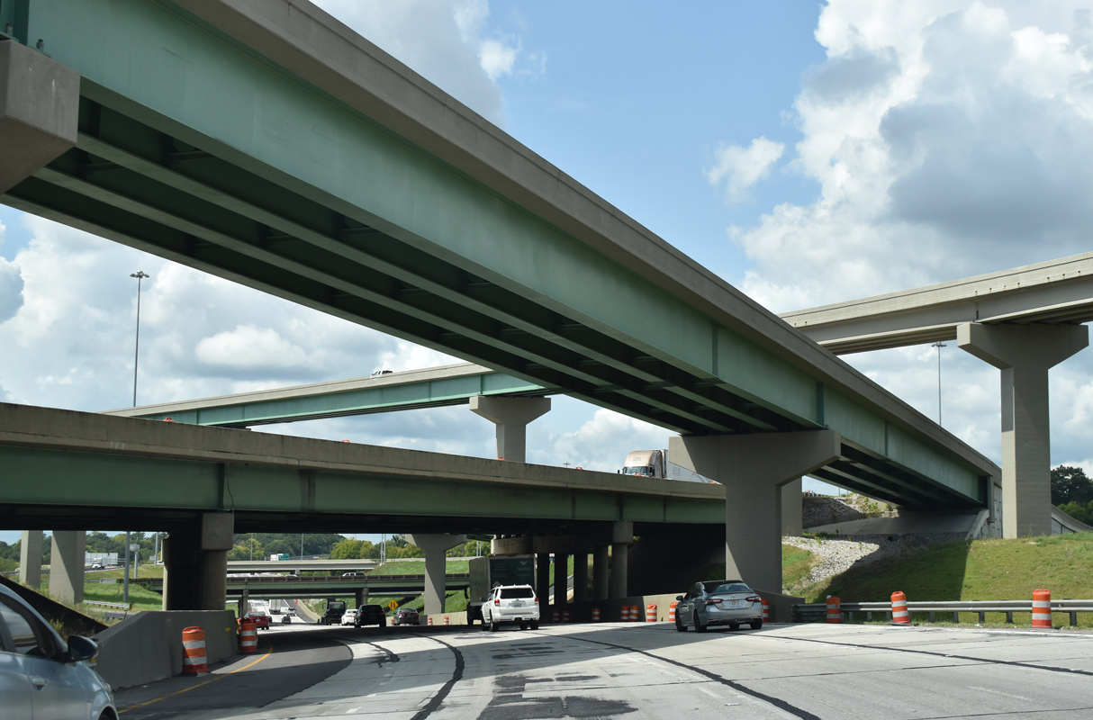
| Shifting southwest to 9th Avenue N, I-20/59 elevate onto a viaduct from U.S. 31/280 to Interstate 65 at what is locally known as "Malfunction Junction." 05/06/22 |
|
| Construction between 2016 and 2020 replaced the elevated roadways built in 1971 along I-59/20 with a new ten lane viaduct system. 05/06/22 |
|
| The Birmingham skyline tops out at 454 feet. Mandated by the FAA (Federal Aviation Administration), the height restriction is due to the proximity of the central business district to the flight path of Birmingham International Airport (BHM).1 05/06/22 |
|
| Home of UAB Football, Protective Stadium was constructed north of I-59/20 from late 2019 to Fall 2021. The 45,000 seat venue is part of BJCC. 05/06/22 |
|
| The elevated roadway along I-59/29 spans Richard Arrington, Jr. Boulevard between the Birmingham-Jefferson Convention Complex and the Jefferson County Courthouse. 05/06/22 |
|
| Auxiliary lanes accompany both directions of I-59/20 between U.S. 31/280 (Elton B. Stephens Expressway) and Interstate 65. 05/06/22 |
|
| Turning northwest above 15th Street N, I-59/20 enter the four-wye interchange (Exit 124) with Interstate 65. Roadways along both freeways switch sides through exchange to accommodate short left exit ramps. 09/11/20 |
|
| Interstate 65 travels four miles north to I-22 west for Memphis and 79.5 miles to I-565 east into Huntsville. Huntsville replaced Nashville as the control point for I-65 in the Birmingham area in the mid 1990s.2 05/06/22 |
|
| Left Exit 124 B joins Interstate 65 south to Homewood, Vestavia Hills, Hoover and the Shelby County suburbs. 09/11/20 |
|
| Reconstruction of "Malfunction Junction" in 2003 expanded I-65 to six overall lanes across I-59/20. Flyovers were added from 11th Avenue N and to 17th Street N in 2017/18. 09/11/20 |
|
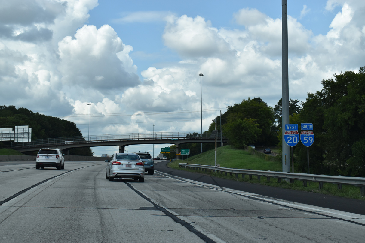
| The succeeding exit along I-59/20 west of I-65 is for U.S. 78/SR 5 (Arkadelphia Road) south to U.S. 11 (3rd Avenue W) and north to Bankhead Highway at SR 378 (Finley Boulevard). 09/11/20 |
|
| Confirming markers posted ahead of the Center Street overpass at the East Thomas neighborhood of Birmingham. 09/11/20 |
|
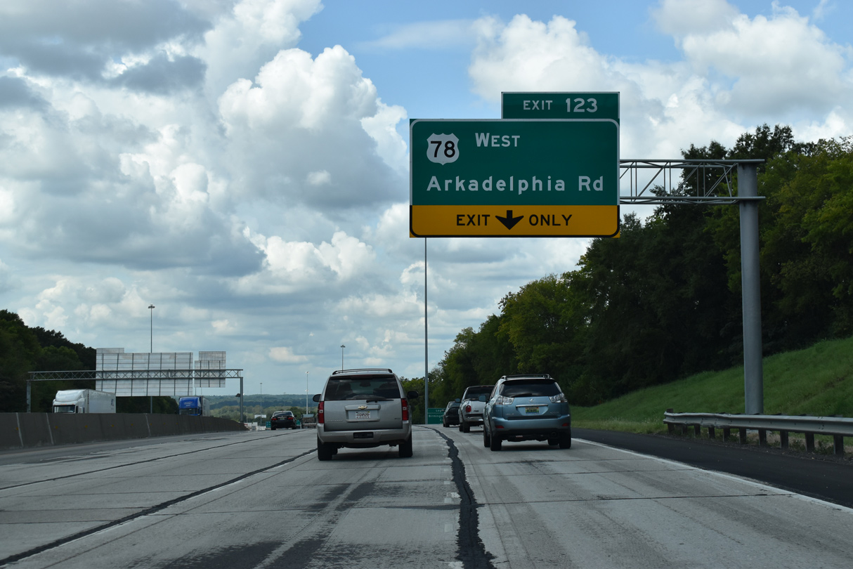
| A lane drop occurs along I-59/20 west at the parclo interchange (Exit 123) with U.S. 78 (Arkadelphia Road). 09/11/20 |
|
| Exit 123 leaves I-59/20 west for U.S. 78/SR 5 and the Birmingham neighborhoods of Thomas, East Thomas, Owenton and Smithfield. 09/11/20 |
|
| Points of interest for Exit 123 include adjacent Birmingham Southern College and Legion Field, a stadium operated by the city of Birmingham. 09/11/20 |
|
| Although not acknowledged on guide signs, SR 5 overlaps with U.S. 78 from U.S. 11 northwest to I-22 at Exit 85 and along former U.S. 78 to Jasper. 09/11/20 |
|
| SR 378 (Finley Boulevard) parallels I-59/20 to the north from U.S. 78/SR 5 (Arkadelphia Road) 2.63 miles east to U.S. 31 (Carraway Boulevard) in North Birmingham. 09/11/20 |
|
| I-20/59 passes just south of a large quarry near East Thomas Gardens. 10/20/12 |
|
| Bending southwest from the Owenton area, I-59/20 continues one mile to a half diamond interchange (Exit 121) with 19th Street Ensley. Bush Boulevard comprises a tree lined boulevard east to 8th Avenue W near Birmingham Southern College. 09/11/20 |
|
| Exit 121 departs I-59/20 south for 19th Street Ensley west and Busch Boulevard east at Ensley. A split diamond interchange follows at Exit 120 for SR 269 (20th Street) north and Ensley/5 Points W Avenue. 09/11/20 |
|
| Beginning at Exit 120, SR 269 (20th Street) travels west to Sylvan Springs and north to Jasper. Ensley/5 Points Avenue leads southeast from I-20/59 to U.S. 78/SR 5 (Bessemer Road) by the sites of the Alabama State Fairgrounds and Birmingham International Raceway demolished in January 2009. 06/12/08 |
|
| The last exit within Birmingham along I-59/20 south connects with Avenue I. Avenue I leads northeast from Valley Road near Oak Hills to Exit 119 B and the Ensley business district. 06/09/17 |
|
| A diamond interchange (Exit 119 A) follows along I-59/20 to the immediate west at Lloyd Noland Parkway in the city of Fairfield. 06/09/17 |
|
| The city of Pleasant Grove lies west beyond Birmingham and Fairfield along Park Road (CR 56). 06/09/17 |
|
| The city street at Exit 119 A was previously R.M. Scrushy Parkway, named after the HealthSouth CEO in the 1990s when the corporation purchased the original Lloyd Noland Hospital in Fairfield. A $2.7 billion accounting fraud scandal involving HealthSouth ensued, ultimately lead to criminal charges against Scrushy.3 Fairfield city county voted to rename the parkway after Lloyd Noland on September 13, 2007.4 06/09/17 |
|
| Curving south around the Fairfield city center, I-59/20 continue to a split diamond interchange (Exit 118) with Valley Road and E.J. Oliver Boulevard. 06/09/17 |
|
| Confirming markers posted ahead of the Crawford Street underpass were removed in 2016. 06/12/08 |
|
| U.S. Steel Parkway stems west from Valley Road to the US Steel complex in unincorporated Jefferson County. 06/09/17 |
|
| I-59/20 reduce to four overall lanes southwest at Exit 118. Valley Road parallels the freeway west onto Allison-Bonnett Memorial Drive at Hueytown. 06/09/17 |
|
| Named after the former Alabama Adventure theme park in Bessemer off Exit 110, I-20/59 is the Alabama Adventure Freeway between Exit 118 and the south end of I-459. The park opened 1998 as Visionland and was rebranded in 2018 as Alabama Adventure Amusement Park & Splash Adventure Water Park.5 06/09/17 |
|
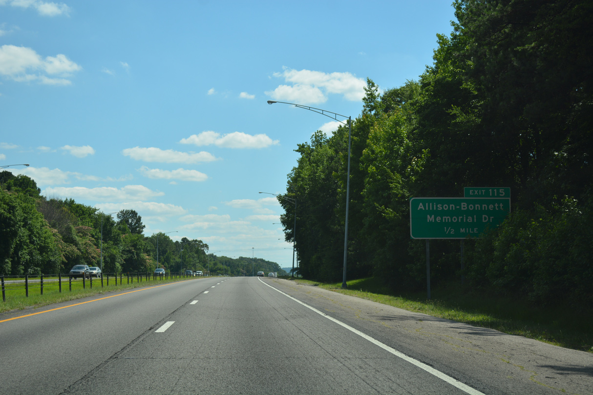
| A wye interchange links I-59/20 within the town limits of Midfield to adjacent Allison-Bonnett Memorial Drive at Exit 115. 06/09/17 |
|
| Allison-Bonnett Memorial Drive connects Valley Road at I-20/59 with the city of Hueytown to the west. 06/09/17 |
|
| Warrior River Road was renamed Allison-Bonnett Memorial Drive in the early 1990s after the Allison family (Bobby, Donnie, Davey and Clifford) and Neil Bonnett, all of whom were NASCAR drivers based out of Hueytown.6 06/09/17 |
|
| Two lanes depart I-20 west / I-59 south at Exit 115 for Hueytown and Rutledge Drive east to Midfield. Allison-Bonnett Memorial Drive becomes Warrior River Road west from Hueytown to Concord. 06/09/17 |
Page Updated 04-28-2023.

 West
West  South
South