|
| Interstate 40 weaves between the West View and Marble City neighborhoods in Knoxville east from I-75/640 to succeeding exits for SR 169 (Middlebrook Pike) at Sutherland Avenue and U.S. 129 (Alcoa Highway) south. 01/16/19 |
|
| Interstate 40 maintains eight overall lanes east to Exit 387. University of Tennessee traffic is directed southward onto U.S. 129 (Alcoa Highway) to the exchange with U.S. 11/70 (Cumberland Avenue) toward Downtown Knoxville. 01/16/19 |
|
| SR 169 (Middlebrook Pike) runs 11.43 miles east from SR 131 (Lovell Road) at Ball Camp to SR 62 (Western Avenue) opposite University Avenue. 01/16/19 |
|
| Exit 386A ties into the intersection of Sutherland Avenue and Partners Place adjacent to SR 169 (Middlebrook Pike). Exit 387 follows onto Dale Avenue east ahead of N 17th Street and SR 62 (Western Avenue). 01/16/19 |
|
| U.S. 129 commences a 582 mile long route to Chiefland, Florida along a freeway south from I-40 across the Tennessee River to University of Tennessee Medical Center. U.S. 129 continues to McGhee Tyson Airport (TYS), Maryville and the Great Smokey Mountains. 01/16/19 |
|
| SR 62 (Western Avenue) joins Oak Ridge with Knoxville from the west. Locally SR 62 joins West Knoxville, Knoxville College and Mechanicsville with Downtown at U.S. 441 (Henley Street) and Summit Hill Drive. 10/15/11 |
|
| A 2.98 mile long connector northwest from U.S. 441 (Henley Street) to I-75/640 near Inskip, Interstate 275 begins at the ensuing exit. 10/15/11 |
|
| Two lanes depart I-40 east for Interstate 275 north at the SR 62 (Western Avenue) overpass. I-275 links Downtown Knoxville with Interstate 75 leading northwest to Rocky Top and Lexington, Kentucky. 10/15/11 |
|
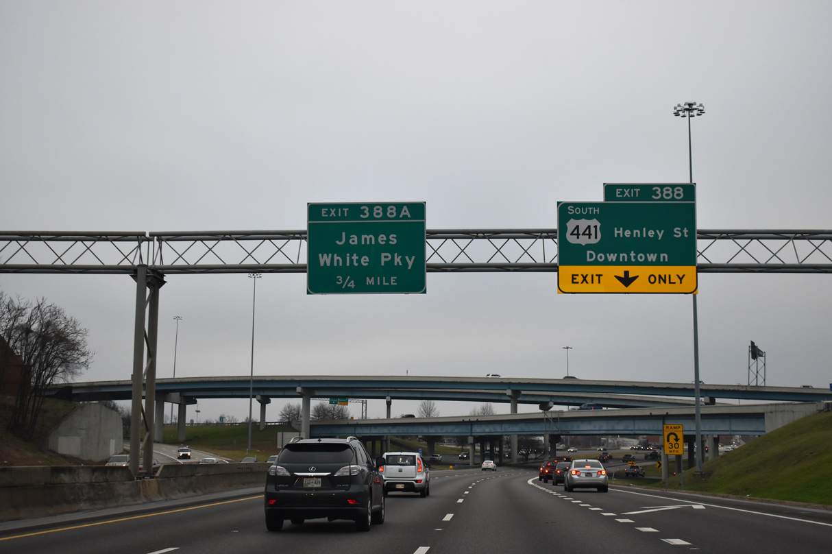
| Exit 388 connects with ramps joining the south end of I-275 with SR 62 (Western Avenue) at 11th Street and U.S. 441 (Henley Street) south ahead of the Knoxville Convention Center. 11/03/11 |
|
| U.S. 441 extends south from Broadway onto Henley Street from SR 62 (Western Avenue) and Summit Hill Drive along the west side of Downtown Knoxville. U.S. 441 spans the Tennessee River across the Henley Street Bridge into South Knoxville. 01/16/19 |
|
| The multi level interchange joining I-40 and I-275 replaced a cloverleaf. 01/16/19 |
|
| Completed in 2009, the Smartfix section of I-40 commences eastbound along a five lane viaduct to the directional T interchange (Exit 388A) with SR 158 (James White Parkway) west to Summit Hill Drive and Downtown Knoxville. Exit 389 follows as a reconfigured diamond interchange with Hall of Fame Drive. 11/08/09 |
|
| Smartfix construction project redesigned Exit 388A to eliminate left side ramps and increase capacity. to SR 158 (James White Parkway) was also improved to Summit Hill Drive. SR 158 is an urban expressway 1.73 miles south to U.S. 11/70 at Neyland Drive along the Tennessee Riverfront. 01/16/19 |
|
| James White Parkway separates from SR 158 south of Summit Hill Drive. Formerly SR 71, the limited access road spans the Tennessee River to Sevierville Pike at South Knoxville. U.S. 11/70 were realigned west over SR 158 around the University of Tennessee to Cumberland Avenue in 2014. 11/08/09 |
|
| Originally the roadways of I-40 partitioned at James White Parkway through a three wye interchange. Work during Smartfix combined the roadways on one overpass above ramps to SR 158 and a reconfigured E 5th Avenue. 11/08/09 |
|
| Hall of Fame Drive was extended northward by November 2007 to connect with Exit 389. SR 33 follows an expressway section of Hall of Fame Drive 0.40 miles north to U.S. 441 (Broadway). 01/16/19 |
|
| An decorative overpass carries Hall of Fame Drive above Interstate 40 at Exit 389. Hall of Fame Drive leads south to the Women's Basketball Hall of Fame. 11/03/11 |
|
| Curving east, Interstate 40 spans First Creek, N 6th Avenue, a Norfolk Southern Railroad line and Mitchell Street. 01/16/19 |
|
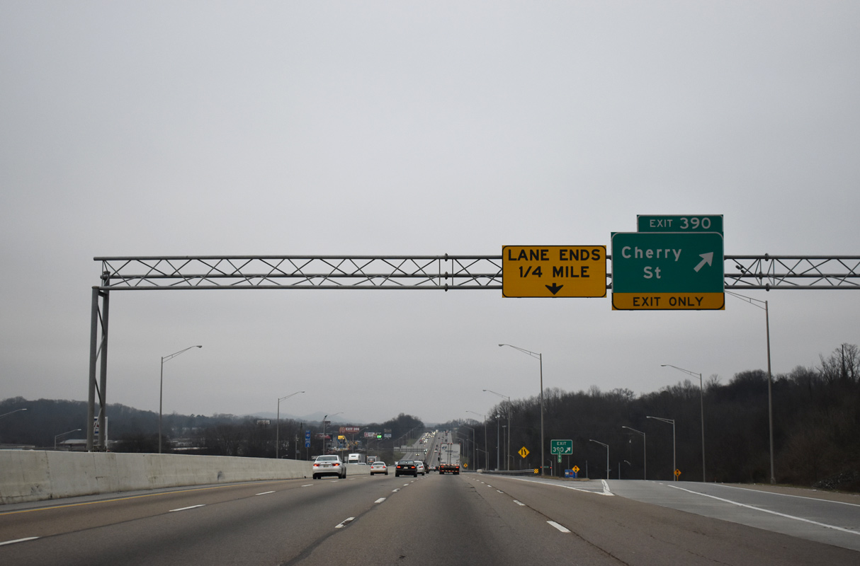
| An auxiliary lane departs at the diamond interchange (Exit 390) with Cherry Street. Cherry Street leads north to Cecil Avenue near the North Knoxville community. 01/16/19 |
|
| Cherry Street east connects Interstate 40 with parallel U.S. 11/70 (Magnolia Avenue) at the Park City neighborhood. The Lane Ends sign here was added by 2011. 01/16/19 |
|
| Advancing east, I-40 leaves the rebuilt Smartfix section. I-640 returns at Exit 393 in two miles. 01/16/19 |
|
| Interstate 40 runs alongside Zoo Knoxville and Chilhowee Park. 01/16/19 |
|
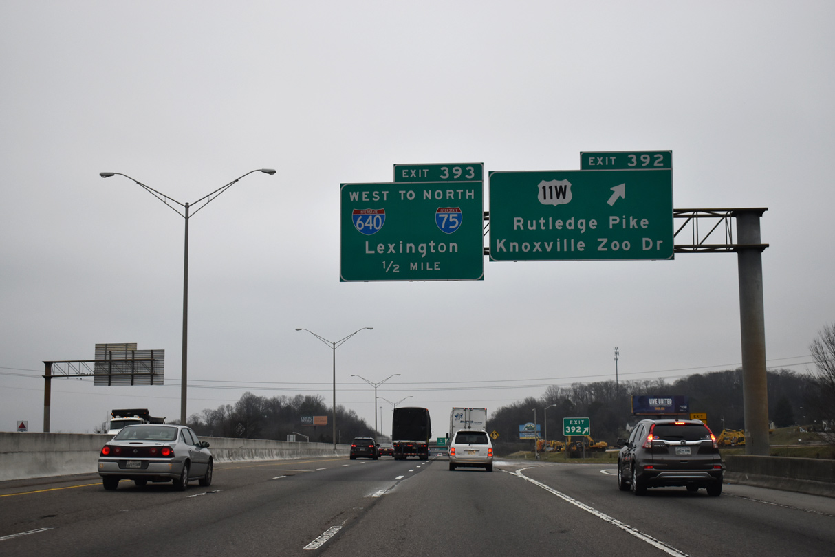
| U.S. 11 (Magnolia Avenue) splits into separate components at the Burlington neighborhood U.S. 11W follows Rutledge Pike north to Exit 392 and John Sevier. U.S. 11E overlaps with U.S. 70 (Asheville Highway) east to Chilhowee Hills and Trentville. 01/16/19 |
|
| U.S. 11W (Rutledge Pike) meets I-40 at a parclo interchange between Timothy Street and Ault Road. Timothy Street stems west from the eastbound off-ramp at Exit 392 to Knoxville Zoo Drive. 01/16/19 |
|
| U.S. 11E/W recombine at Bristol. U.S. 11W stretches 111 miles through Rutledge, Rogersville and Kingsport while U.S. 11E takes a more southerly route 121 miles through Morristown, Greeneville and Johnson City.
I-640 loops westward from Exit 393, 7.04 miles back to I-75. 01/16/19 |
|
| The directional T interchange (Exit 393) with I-640 west and U.S. 25W north lies a half mile east of the Spring Hill Road overpass. 01/16/19 |
|
| I-640/U.S. 25W overlap west to Clinton Highway at Exit 3B. U.S. 25W joins I-40 east for 0.66 miles from Interstate 640 to Exit 394. 01/16/19 |
|
| U.S. 11E/70 (Asheville Highway) branch 2.06 miles east from U.S. 11W (Rutledge Pike) at Burlington to Chilhowee Hills and a diamond interchange (Exit 394) with I-40/U.S. 25W. U.S. 25W combines with U.S. 11E/70 east 6.02 miles near Trentville. 05/01/05 |
|
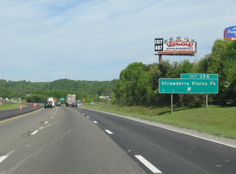
| Strawberry Plains Pike runs northeast from SR 168 (Governor John Sevier Highway) to Moshina Heights and the diamond interchange at Exit 398. Strawberry Plains Road extends northward to Wooddale and U.S. 25W/70 (Asheville Highway) at Kitts Road to U.S. 11E. 05/01/05 |
|
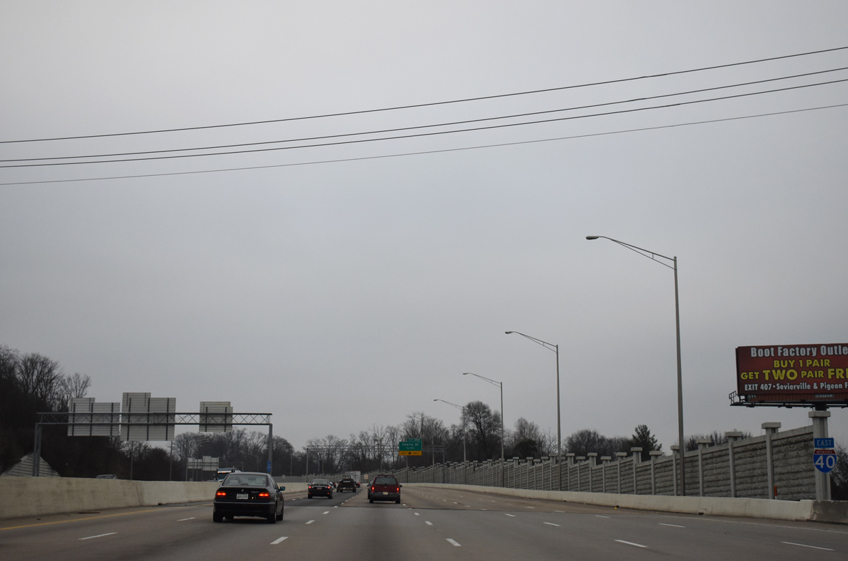
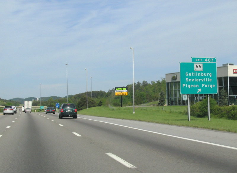
| I-40 meets the north end of SR 66 (Winfield Dunn Parkway) at a diverging diamond interchange (Exit 407) in northern reaches of Sevierville. An 8.60 mile long four lane highway, SR 66 connects I-40 with U.S. 441 south toward Gatlinburg and the Great Smoky Mountains. U.S. 441 runs 4.66 miles south from SR 66 to combine with U.S. 321 at the town of Pigeon Forge. 05/01/05 |
Page Updated 06-25-2021.


 East
East