|
| Interstate 55 next meets the village of Farmersville at Exit 72 in one mile. 12/31/23 |
|
| Historic U.S. 66 (W Frontage Road) leads south from Exit 72 to connect with Main Street west into the village of Waggoner. The village of Morrisonville lies 11 miles to the east via CR 17 (Mine Avenue), CR 3 (Main Street) and Morrisonville Avenue (CR 27 and CR 10). 12/31/23 |
|
| Exit 72 is a folded diamond interchange with Main Street west and Mine Road east at Farmersville. These roads double as County Route 17. 12/31/23 |
|
| County Route 17 continues Mine Avenue west from Farmersville to Macoupin County and the city of Girard along IL 4. 12/31/23 |
|
| Southbound I-55 traffic leaves the Farmersville area and crosses Macoupin Creek. 12/31/23 |
|
| Interstate 55 south from Springfield is designated the Vince Demuzio Expressway in honor of the Carlinville, Illinois State Senator. 05/06/18 |
|
| An eight mile exit less stretch leads Interstate 55 south across northwestern Montgomery County. East St. Louis is over an hour away. 12/31/23 |
|
| Passing by the village of Waggoner, Interstate 55 advances south to the penultimate set of rest areas in Illinois. 12/31/23 |
|
| Entering the Coalfield Rest Area in northwest Montgomery County. The northbound facility lies nearby at milepost 64. 12/31/23 |
|
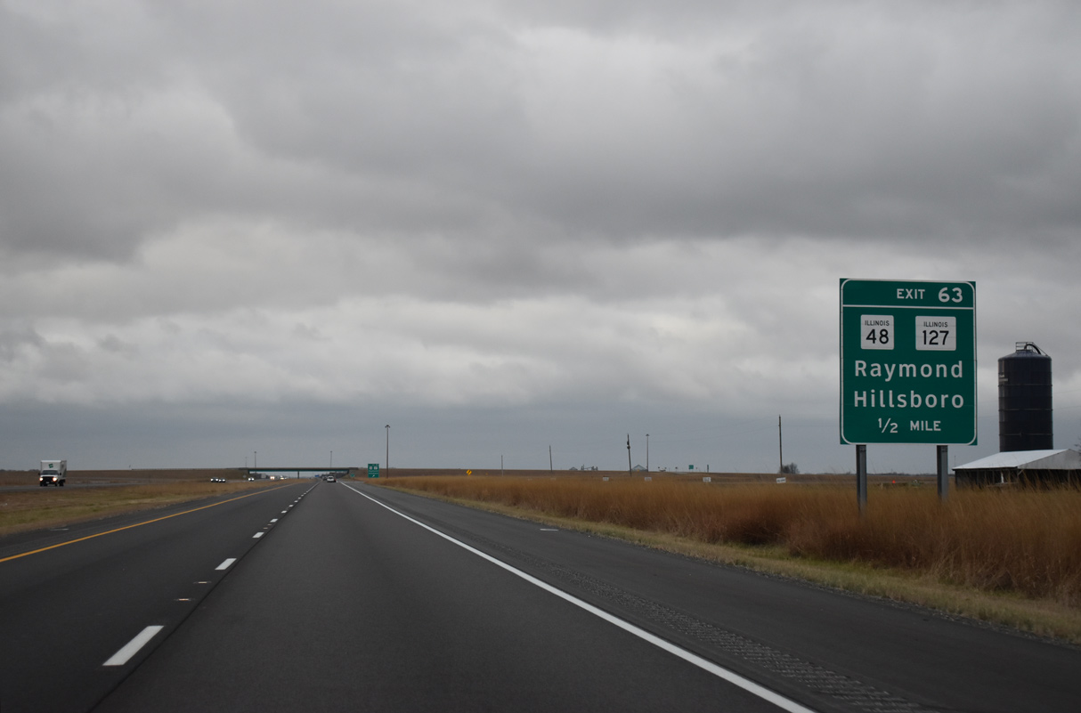
| Continuing south, Interstate 55 reaches the diamond interchange (Exit 63) with IL 48 north and IL 127 south, three miles west of Raymond. 12/31/23 |
|
| IL 48 and IL 127 both begin at Exit 63. The state routes part ways at Raymond, with IL 48 branching northeast to Morrisonville and Taylorville and IL 127 turning south to Hillsboro and Greenville. 12/31/23 |
|
| Exit 63 departs from Interstate 55 south for 22nd Avenue west and IL 48/127 east. IL 48 travels 80 miles overall from Exit 63 to Decatur and IL 54 west of Farmer City. IL 127 ventures 179 miles south to Unity. 12/31/23 |
|
| Interstate 55 reassurance marker posted ahead of the Fivemile Lake area. Historic U.S. 66 continues along the adjacent frontage road. 12/31/23 |
|
| One mile north of the diamond interchange (Exit 60) with IL 108 near Honey Bend. 12/31/23 |
|
| IL 108 begins at Interstate 55 from 19th Avenue and heads west 54 miles to a free ferry across the Illinois River to Kempsville. 12/31/23 |
|
| Southbound at Exit 60 to IL 108 west and 19th Avenue east. Carlinville, seat of Macoupin County, is 12 miles to the west. The settlement of Honey Bend lies southeast via 19th Avenue and E 4th Road. 12/31/23 |
|
| Interstate 55 and Historic U.S. 66 continue together three miles to the 16th Avenue overpass. There the historic route branches eastward to parallel a Norfolk Southern Railroad line into Litchfield. 12/31/23 |
|
| Litchfield, the largest community between Springfield and the St. Louis suburbs, is eight miles ahead. East St. Louis is 57 miles away. 12/31/23 |
|
| Interstate 55 turns southwest alongside E Frontage Road (old U.S. 66) and a Norfolk Southern Railroad west of Lake Yaeger. 12/31/23 |
|
| IL 16, a 190 mile long highway from near Biggsville east to Ashkum, meets Interstate 55 in one mile at Exit 52. 12/31/23 |
|
| A six-ramp parclo interchange (Exit 52) links Interstate 55 with IL 16 on the west side of Litchfield, a city of around 6,600. 12/31/23 |
|
| IL 16 follows Union Avenue to Downtown Litchfield and reaches Gillespie eight miles to the west. East of Litchfield, the state route heads ten miles to Hillsboro. Two alignments of Historic U.S. 66 cross IL 16 nearby: Historic Old Route 66 and Columbian Boulevard. 12/31/23 |
|
| Interstate 55 passes just west of Litchfield Municipal Airport (3LF) on the ensuing stretch southbound. Historic U.S. 66 stays well east of the freeway from the airport south into Mount Olive. 12/31/23 |
|
| IL 138 at White City, outside Mount Olive, is next along I-55 south in seven miles. East St. Louis and Downtown St. Louis are within an hour's drive. 12/31/23 |
|
| Turning southwesterly, Interstate 55 enters the southeast corner of Macoupin County. 12/31/23 |
|
| IL 138 (Lakeview Drive) and Interstate 55 come together within the village of White City at Exit 44. The state route provides a direct route to Downtown Mt. Olive along Main Street to the east. 12/31/23 |
|
| Interstate 55 skirts Old Mount Olive Reservoir on the half leading to Exit 44 and IL 138 (Lakeview Drive). 14 miles in length, IL 138 concludes to the west at IL 159 near Bunker Hill. 12/31/23 |
|
| West from Exit 44 and White City, IL 138 takes a stair-stepped course northward onto 8th and Central Streets through the city of Benld. 12/31/23 |
|
| Exit 44 leaves Interstate 55 south for IL 138 (Lakeview Drive). IL 138 ends at Illinois Street, the second alignment of U.S. 66, in Mt. Olive. The third U.S. 66 alignment, the bypass of Mt. Olive, is 0.25 miles east of Exit 44. The original U.S. 66 remains along IL 4 through Gillespie and Staunton to the west. 12/31/23 |
|
| Vacating the White City area, Interstate 55 passes by Staunton Reservoir to the west and reconvenes with Historic U.S. 66 at Exit 41. 05/06/18 |
|
| Serving Staunton, a city of around 5,000 to the west, Exit 41 connects with Main Street / Staunton Road. 12/31/23 |
|
| Another old alignment of U.S. 66, its second, passes over Interstate 55 a half mile from the diamond interchange at Exit 41. This stretch of Historic U.S. 66 angles southwest along the periphery of Staunton to combine with the first iteration of U.S. 66 along IL 4. 12/31/23 |
|
| Exit 41 leaves I-55 south for Staunton Road west to Staunton and east to Montgomery County Route 12 (Bodner Avenue). Again the freeway directly overlays the four lane route of U.S. 66 (W Frontage Road) southward toward Hamel. 12/31/23 |
|
| Interstate 55 and the companion frontage road system ply across agricultural areas east of Staunton. 12/31/23 |
|
| 1.5 miles removed from Exit 41, Interstate 55 south enters northeastern Madison County. 12/31/23 |
|
| Interstate 55 and adjacent U.S. 66 proceed to the village of Livingston and the diamond interchange (Exit 37) with Nichols Street. The two routes span a Union Pacific Railroad line ahead of town. 12/31/23 |
|
| Nichols Street stems west from Interstate 55 and New Douglas Road to the Livingston village center. Nichols Street connects Historic U.S. 66 with Veterans Memorial Drive southwest toward Hamel. 12/31/23 |
|
| New Douglas, a village of 350 (2020 census), is 4.8 miles east from Exit 37 via New Douglas Road to Deck Street. 12/31/23 |
|
| Interstate 55 runs along the east side of the Livingston street grid by this reassurance marker. 12/31/23 |
|
| Alhambra Road spans both the Interstate 55 mainline and Historic U.S. 66 (W Frontage Road) beyond this distance sign posted 34 miles north of East St. Louis. 12/31/23 |
|
| IL 4, a 160 mile long highway from Springfield to IL 13 in Jackson County, converges with Interstate 55 at Exit 33 in one mile. 12/31/23 |
|
| Six miles south of Staunton, IL 4 intersects Possum Hill Road and Interstate 55 at a diamond interchange (Exit 33). Possum Hill Road connects the freeway with Worden to the west.
12/31/23 |
|
| IL 4 follows much of the first alignment of U.S. 66, except where modernization and realignments have occurred, south from Springfield to Carlinville, Gillespie and Staunton. 12/31/23 |
|
| A second reassurance marker stands along the stretch of I-55 south between Exits 37 and 33 by Lindenbroker Road. 12/31/23 |
|
| Continuing south from Exit 33, IL 4 reaches Lebanon in 23 miles. This stretch of IL 4 was originally designated IL 43. 12/31/23 |
|
| Historic U.S. 66 remains alongside I-55 south for another two miles before branching westward into Hamel. 12/31/23 |
|
| One mile north of the diamond interchange (Exit 30) with IL 140 (State Street) on Interstate 55 south. 12/31/23 |
|
| Exit 30 departs I-55 south into the village of Hamel. IL 130 follows State Street through the community of over 900 on the 12 miles west to Bethalto. 12/31/23 |
|
| IL 140, a 65 mile long highway between Alton and Vandalia, links Hamel and I-55 with Greenville, 23 miles to the east. 12/31/23 |
|
| Beginning 0.20 miles west from Exit 30, IL 157 continues Old US Route 66 southwest to Edwardsville. 12/31/23 |
|
| The final rest area in Illinois lies one mile beyond IL 140. 12/31/23 |
|
| Resurfacing work along I-55 from IL 140 south to I-70 and I-270 was underway between November 2010 and December 2011. 12/31/23 |
|
| Interstate 55 next meets IL 143 outside Edwardsville in six miles. East St. Louis and Downtown St. Louis are a half hour away. 12/31/23 |
|
| Southbound Interstate 55 reaches the Homestead Rest Area, located at milepost 27. 12/31/23 |
|
| Continuing south from the Homestead Rest Area, I-55 passes under Maple Road beyond this shield assembly. 12/31/23 |
|
| IL 143 (Veterans Memorial Drive) joins Interstate 55 with the city center of Edwardsville to the west of the diamond interchange at Exit 23. 12/31/23 |
|
| Governors Parkway separates with IL 143 just west of Exit 23 to encircle the south side of Edwardsville to University Drive by the Southern Illinois University-Edwardsville (SIUE) campus. 12/31/23 |
|
| East from Exit 23, IL 143 travels along a rural course to Marine and Highland. The 32 mile long highway ends at Alton to the west and Beavercreek to the east. 12/31/23 |
|
| This sign references I-55 as the Paul Simon Freeway south ahead of I-70/270. The bow-tie honors former Illinois Congressman Paul Simon, who regularly wore one. 12/31/23 |
|
| A confirming marker precedes the Goshen Road overpass, west of Kuhn Station. 12/31/23 |
|
| Forthcoming Exits 20 B/A join I-55 south with Interstate 270 west to St. Charles, Missouri and Interstate 70 east to Vandalia and Effingham. A three quarter cloverleaf interchange links I-55 with I-270, while the I-70 mainline bypasses that exchange to the east along directional ramps. 12/31/23 |
|
| Glen Carbon Heritage Bike Trail 12/31/23 |
|
| Interstate 55 continues to directly overlay the final alignment of U.S. 66 to Troy. IL 162, historic U.S. 40 Bypass, follows I-70 and I-270 at Exit 18. 12/31/23 |
|
| Long distance travelers bound for Kansas City, Missouri are directed onto Interstate 270 across the Mississippi River to bypass St. Louis as I-70 loops southward into the city. I-270 encircles the metro area along a 50.59 mile route west to Maryland Heights and south to Mehlville. 12/31/23 |
|
| Exit 20 B departs immediately after the Maple Grove Road overpass for Interstate 270 west. I-270 serves Glen Carbon and Granite City as Interstate 70 turns south alongside I-55 for a 15.5 mile overlap. 12/31/23 |
|
| Interstate 70 eastbound stays north of Troy en route to Highland, Greenville, Vandalia and Effingham. The freeway joins St. Louis with Indianapolis and Columbus, Ohio as part of a 2,153 mile route between Cove Fort, Utah and Baltimore, Maryland. 05/06/18 |
Page Updated 01-08-2024.

 South
South