|
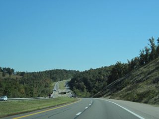
| Interstate 64 eastbound exits Daniel Boone National Forest but remains vastly rural on the mountainous stretch through northwest Clark County. This scene looks at the approach to Fleming Fork. 10/02/10 |
|
| Undulating eastward toward the crossing of Flat Fork of Tygarts Creek. 10/02/10 |
|
| Eastbound near the crossing of Reeves Branch. 10/02/10 |
|
| The first of three Carter County interchanges joins Interstate 64 with KY 2 at the Exit 156 diamond interchange in two miles. 10/02/10 |
|
| KY 2 intersects KY 59 on the north side of Interstate 64. KY 59 ventures northward 20 miles to Kinniconick and 27 miles to Vanceburg. 10/02/10 |
|
| Exit 156 departs Interstate 64 east for KY 2. KY 2 totals 37 miles from U.S. 60 at Olive Hill northeast to Carter, Warnock and Greenup. 10/02/10 |
|
| Ascending along the Exit 156 off-ramp to KY 2. KY 59 begins just north of the interchange and follows a winding path west to Rose Hill and Emerson. Olive Hill is a three mile drive to the south via KY 2 to U.S. 60 (Tom T. Hall Boulevard), the main route town. 10/02/10 |
|
| Turning more southeasterly, Interstate 64 parallels Trough Camp Creek from near Exit 161 to Counts Crossroads. 10/02/10 |
|
| An eight mile trek returns eastbound drivers to Olive Hill via U.S. 60 west at the next exit. Grayson, the county seat, follows in 15 miles. 10/02/10 |
|
| Continuing east through the Trough Camp Creek valley along Interstate 64. 10/02/10 |
|
| Two miles west of the diamond interchange (Exit 161) with U.S. 60 at the KY 1025 under pass. 10/02/10 |
|
| Exit 161 serves interests to Carter Caves Resort State Park via U.S. 60 east to KY 209, a 2.37 mile loop from U.S. 60 to through the park. 10/02/10 |
|
| U.S. 60 and Interstate 64 cross paths just north of Counts Crossroads amid quarries and agricultural lands. U.S. 60 exits Olive Hill and joins with KY 182 (Grahn Road) briefly through Exit 161 to a split near Box Canyon to the north. 10/02/10 |
|
| U.S. 60 remains somewhat close to Interstate 64 from Exit 161 east to Gregoryville, Grayson and Kilgore to meet the freeway again at Exit 181. KY 182 arcs northwest seven miles from U.S. 60 to end at KY 2; southward the state route continues to Grahn and KY 986 near Grayson Lake. 10/02/10 |
|
| Reassurance shield and guide sign assemblies posted ten miles west of Grayson and 31 miles from Ashland. 10/02/10 |
|
| The landscape of Interstate 64 eastbound beyond milepost 163. 10/02/10 |
|
| Interstate 64 east at milepost 165. 10/02/10 |
|
| Paralleling Davis Fork along Interstate 64 along the hillside separating the freeway from U.S. 60. The US Highway follows Barrett Creek to the north before converging with Interstate 64 at Gregoryville. 10/02/10 |
|
| Farm fields replace immediate hill sides adjacent to Interstate 64 as the freeway enters a wide valley with U.S. 60 by Barrett Creek. The two routes swap sides, with U.S. 60 venturing east to Grayson and Interstate 64 bypassing town to the north. 10/02/10 |
|
| KY 1/7 (Carol Malone Boulevard) combine in Downtown Grayson for a 1.4 mile overlap northward to the diamond interchange (Exit 172) with Interstate 64 and Pactolus. 10/02/10 |
|
| KY 9 (AA Highway) was extended eastward to KY 1/7, north of Grayson, in 1991. The AA Highway, which stands for Alexandria to Ashland, is a controlled access route carrying between two and four lanes west to Vanceburg, Maysville and Interstate 275 outside Newport. 10/02/10 |
|
| Eastbound Interstate 64 reaches Exit 172 to KY 1/7 (Carol Malone Boulevard). KY 1 travels a circuitous route for 47.79 miles from KY 3 near Fallsburg to Willard, Grayson and U.S. 23 at Greenup. KY 7 follows a much longe route, traveling 166 miles from KY 15 near Hazard in southeastern Kentucky, to an end at KY 2 in northern Carter County. 10/02/10 |
|
| Leaving Grayson, Interstate 65 approaches Sandy Creek on the nine mile drive to the next U.S. 60 meeting. This distance sign predates the opening of the Exit 179 trumpet interchange with KY 67 (Industrial Parkway). 10/02/10 |
|
| The final eastbound rest area in Kentucky follows as the roadways of Interstate 64 separate. 10/02/10 |
|
| Approaching the eastbound rest area of Interstate 64 east by Beckwith Branch. Westbound travels up to 2000 feet to the north of eastbound along this hilly stretch. 10/02/10 |
|
| A reassurance marker resides beyond the rest area as Interstate 64 nears the Wilson Creek Road overpass. 10/02/10 |
|
| Wilson Creek Road stems north from U.S. 60 to Sugarcane Hollow along Wilson Creek to pass over Interstate 64 in this scene. 10/02/10 |
|
| Industrial Parkway was constructed between 2002 and 2003 to link Interstate 64 with U.S. 23 at Wurtland. Currently the road carries two overall lanes, but right of way provisions were made should the need arise for four-laning. 10/02/10 |
|
| One mile west of the KY 67 (Industrial Parkway) northbound beginning along Interstate 64 east at the KY 207 overpass. KY 67 totals 14.22 miles to Wurtland by the Ohio River; U.S. 23 connects drivers with the Greenup County seat three miles to the west of the north end. 10/02/10 |
|
| Exit 179 departs Interstate 64 east for KY 67 (Industrial Parkway) north. KY 67 north immediately enters the southern tip of Greenup County. 10/02/10 |
|
| Continuing east, Interstate 64 next meets Huntington, West Virginia in 19 miles. Ashland lies the northeast via U.S. 60 in 12 miles. 10/02/10 |
|
| U.S. 60 winds east along Star Creek to meet KY 854 at Kilgore before turning north to the Exit 181 folded diamond interchange. 10/02/10 |
|
| Crossing into Boyd County, the final county of Interstate 64's 191.51 miles across the Bluegrass State. 10/02/10 |
|
| Exit 181 omits any destination for U.S. 60 from Interstate 64 east. U.S. 60 east generally serves local interests through Coalton, Princess and KY 160. KY 854 loops south from U.S. 60 west and Kilgore to Rush and KY 3. 10/02/10 |
|
| Spanning U.S. 60 and the parallel CSX Railroad line, Interstate 64 stays south of Cannonsburg and Ashland on the nine mile drive to West Virginia. 10/02/10 |
|
| Exit 185 provides the main route to Ashland via four lane KY 180 north to U.S. 60 at Cannonsburg. Motorists bound for Paramount Arts Center and Ashland Community and Technical College should follow U.S. 60 east from the end of KY 180 to the Ohio River city of 21,684. 10/02/10 |
|
| Interstate 64 separate at the Exit 185 diamond interchange over the East Fork Little Sandy River. KY 180 and U.S. 60 lead drivers ten miles north to U.S. 23 and the Ohio River bridges to U.S. 52 and Coal Grove, West Virginia. Southward KY 180 concludes a 2.51 mile path at KY 3 near Mavity. 10/02/10 |
|
| Ashland appears again for U.S. 23 on this eastbound distance sign posted 18 miles west of Huntington, West Virginia. 10/02/10 |
|
| Approaching Laurel Ridge along Interstate 64 east. 10/02/10 |
|
| U.S. 23 (Country Music Highway) winds south along the Ohio River seven miles from Ashland to Catlettsburg, the Boyd County seat, before meeting Interstate 64 at a diamond interchange (Exit 191). 10/02/10 |
|
| Parallel KY 3 comes into view on the 1.25 mile approach to U.S. 23 (Exit 191) on I-64 east. U.S. 23 continues south from the freeway 24 miles to Louisa, where the route diverges from the Big Sandy River to Paintsville, Prestonsburg and Pikeville. 10/02/10 |
|
| Eastbound at the Exit 191 ramp departure to U.S. 23 (Country Music Highway). U.S. 23 combines with U.S. 60 from Catlettsburg to Ashland; U.S. 60 east spans the Big Sandy River to Kenova, West Virginia nearby. Overall U.S. 23 is a 1444 mile route that goes from Jacksonville, Florida to Mackinaw City, Michigan. 10/02/10 |
|
| The next exit (U.S. 52 south) is the first within the Mountaineer State at the railroad cities of Kenova and Ceredo along the Ohio River. 10/02/10 |
|
| Charleston, the capital of West Virginia, debuts along Interstate 64, 62 miles west of the city at the state line. 10/02/10 |
|
| The Big Sandy River flows north from 29 miles from Louisa to the Ohio River at Catlettsburg, separating Kentucky from West Virginia south of the Ohio River. Interstate 64 spans the waterway along the Perry & Gentry Memorial Bridge. The eastbound bridge opened in 1967; the westbound span was rebuilt in 1998. 10/02/10 |
|
| Oil refineries and containment facilities line a bend above the west banks of the Big Sandy River on both sides of Interstate 64. A portion of Old U.S. Route 23 runs through the industrial area and is no longer open to the public. 10/02/10 |
Page Updated 03-11-2012.

 East
East


