|
| The roadways of I-75 separate as the freeway undulates over a series of forested hills east of Bethlehem Bottoms. 09/06/20 |
|
| Interstate 75 leaves the city of Locust Grove and next reaches the suburb of McDonough in seven miles. Atlanta is a half hour drive to the north. 09/06/20 |
|
| The I-75 South Metro Express Lanes commence along Interstate 75 north at McDonough. 05/06/22 |
|
| The I-75 South Metro Express Lanes consist of a single reversible lane running between the north and southbound roadways of I-75 to SR 20/81. Two lanes extending north from there to SR 138 at Stockbridge. 05/06/22 |
|
| SR 155 (McDonough Road) crosses paths with Interstate 75 at the first of three interchanges for the city of McDonough. Several groups of warehouses and distribution centers line SR 155 between Luella and Blacksville in McDonough. 05/06/22 |
|
| Variable toll rates are charged along the I-75 South Metro Express Lanes depending upon time of day and traffic flow. 05/06/22 |
|
| A folded diamond interchange (Exit 216) joins I-75 with SR 155 adjacent to a Norfolk Southern Railroad line. SR 155 travels 57.07 miles overall between U.S. 19/41 in Griffin and U.S. 23/SR 13 at Brookhaven. 05/06/22 |
|
| Construction on the I-75 South Metro Express Lanes ran from October 2014 through early 2017. 09/22/22 |
|
| Exit 216 loops away from I-75 north to SR 155 (McDonough Road). The succeeding exit is for SR 20/81 (Hampton-McDonough Road) in 1.25 miles. 09/22/22 |
|
| The I-75 South Metro Express Lanes begin within the exchange (Exit 216) at SR 155 (McDonough Road). 09/22/22 |
|
| Supporting adjacent commercial development, Industrial Boulevard and Avalon Parkway parallel I-75 north to the retail corridor along SR 20 (Hampton-McDonough Road). 09/06/20 |
|
| SR 81 combines with SR 20 just west of the diamond interchange at Exit 218. SR 81 forms a 68.97 mile long arc northeast from U.S. 19/41 near Lovejoy to McDonough, Covington, Loganville and U.S. 29 Business at Winder. 09/06/20 |
|
| SR 20 meanders 8.70 miles west from Exit 218 along a four lane highway to U.S. 19/41 and Lower Woosley Road at Hampton. SR 20 overlaps with SR 81 east to the McDonough city center, where it turns north to encircle the Atlanta metropolitan area to I-75 again near Cartersville. 09/06/20 |
|
| The second ingress point for the I-75 South Metro Express Lanes northbound precedes Birch Creek beyond SR 20/81 at McDonough. 09/06/20 |
|
| Sound walls were installed just north of Exit 218 as part of the $176 million project to build the I-75 South Metro Express Lanes.1 09/06/20 |
|
| There are no further ingress points to the I-75 South Metro Express Lanes from the I-75 general travel lanes northbound. A final entrance ramp however joins Jonesboro Road with the toll lanes at Exit 221. 05/06/22 |
|
| Jonesboro Road extends west from Jonesboro Street in McDonough as an arterial route to a commercialized diamond interchange (Exit 221) with I-75 north in one mile. 05/06/22 |
|
| West from Exit 221, Jonesboro Road advances from the adjacent Henry Town Center retail area through unincorporated suburbs to the city of Lovejoy. 09/06/20 |
|
| Part of the future realignment of SR 81, Jonesboro Road is designated temporarily as Georgia State Route 920.2 Unsigned SR 920 comprises a 17.05 mile long route west from U.S. 23/SR 42/81 in McDonough to SR 54 outside the city of Fayetteville. 05/06/22 |
|
| Jodeco Road winds 7.12 miles west from U.S. 23/SR 42 through unincorporated Flippen to the Clayton County line by Lake Spivey en route to the Jonesboro. The minor arterial meets I-75 at a diamond interchange (Exit 222) that was revamped by April 2015. 09/06/20 |
|
| Exit 222 departs I-75 north for Jodeco Road east to Flippen. Until 1982, Jodeco Road was a part of SR 351, a 13 mile long route from U.S. 23 to Main and College Streets in Jonesboro.3 05/06/22 |
|
| Interstate 75 advances north to the city of Stockbridge and Exit 224 with Hudson Bridge Road west and Eagles Landing Parkway east. 05/06/22 |
|
| Collectively Hudson Bridge Road and Eagles Landing Parkway form a multilane arterial east from Jodeco Road to U.S. 23/SR 42 (Atlanta Highway) at Lake Parkway. The roadway serves a number of businesses and Piedmont Henry Hospital. 05/06/22 |
|
| Ramp meters operate on the inbound ramp to I-75 at the diamond interchange with Hudson Bridge Road west and Eagles Landing Parkway east. Ramp meters are in use along most of the Atlanta freeway network. 05/06/22 |
|
| Angling northwest through the Stockbridge city limits, I-75 proceeds two miles to a wye interchange (Exit 227) with Interstate 675 north. 12/20/23 |
|
| Walt Stephens Road spans I-75 one mile from the separation with I-675 at Exit 227. Opened in 1987, Interstate 675 provides a more direct route to the eastern half of the Perimeter Highway (I-285) in DeKalb County. 12/20/23 |
|
| The I-75 South Metro Express Lanes conclude beyond the exit for Interstate 675 north. 12/20/23 |
|
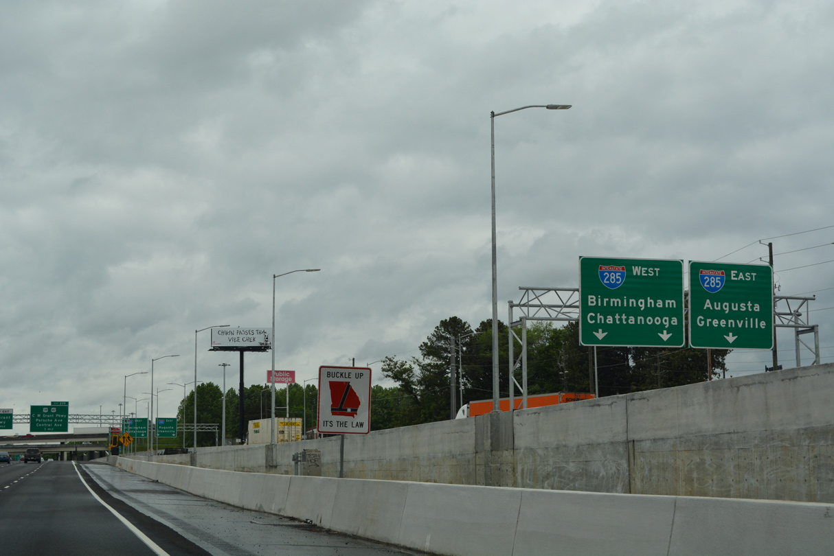
| The general travel lanes of I-75 partition with a two lane ramp (Exit 227) for I-675. I-675 to I-285 north connects I-75 with I-20 east to Augusta at Exit 46 and I-85 north to Greenville at Exit 39. 12/20/23 |
|
| Exit 227 departs I-75 north for I-675 north. Retaining a rural design, I-675 travels 11.10 miles through four interchanges in the Clayton County suburbs. 12/20/23 |
|
| SR 138 (Stockbridge Road) ties into both I-75 and I-675 at their next respective exits. SR 138 comprises the main route between Jonesboro and Stockbridge, measuring 6.33 miles from SR 54 to U.S. 23/SR 42. 12/20/23 |
|
| Entering the diamond interchange (Exit 228) with SR 138 (Stockbridge Road) on I-75 north. Jonesboro lies five miles to the west. SR 138 however bypasses the city northward between Stockbridge Road and North Avenue en route to Riverdale. 12/20/23 |
|
| I-75 South Metro Express Lanes transition into the fourth general travel lane for Interstate 75 north within the exchange at Exit 228. 05/06/22 |
|
| Paralleling Mt. Zion Road, I-75 crosses into northeast Clayton County. 06/30/17 |
|
| A six ramp parclo interchange (Exit 231) joins I-75 with Mt. Zion Boulevard one mile to the northwest of the Fielder Road overpass by the city of Morrow. 05/06/22 |
|
| Mount Zion Boulevard arcs northeast from Southlake Parkway in Jonesboro to Rex Road west of U.S. 23/SR 42. Mt. Zion Road north and Mt. Zion Parkway south tie into the arterial from adjacent retail along the west side of I-75. 05/06/22 |
|
| SR 54 (Jonesboro Road) and I-75 come together in 0.75 miles at Exit 233 by Southlake Mall. 05/06/22 |
|
| Revisions at Exit 233 completed by 2012 both widened the off-ramp to two lanes and lengthened it southward to separate from I-75 ahead of the Meadowbrook Lane underpass. This overhead was removed between April and November 2021. 06/30/17 |
|
| SR 54 (Jonesboro Road) constitutes a commercial boulevard leading south 2.7 miles to SR 138 in Jonesboro. North of Exit 233, SR 54 runs through Morrow to Lake City and Forest Park. 05/06/22 |
|
| U.S. 19/41-SR 3 (Old Dixie Highway / Tara Boulevard) head north from Jonesboro to I-75 and Forest Park. A half diamond interchange (Exit 235) provides access from northbound and a wye interchange southbound. 05/06/22 |
|
| U.S. 19/41 combine from Griffin northward into Atlanta, meeting I-75 north in one half mile. 05/06/22 |
|
| Exit 235 leaves Interstate 75 north for U.S. 19/41-SR 3 (Old Dixie Highway) at a east side Frontage Road. Old Dixie Highway runs east of the freeway as an industrial roadway through Forest Park to Exit 239. 05/06/22 |
|
| The aforementioned Frontage Road coincides with I-75 northward from U.S. 19/41 to Interstate 285. I-75 gains an auxiliary lane between Exit 235 to 237 for SR 331 (Forest Parkway). SR 331 constitutes a 3.28 mile long route between SR 85 and SR 54 (Jonesboro Road). 05/06/22 |
|
| Interstate 285 west serves domestic travelers for Hartsfield-Jackson International Airport (ATL) while I-75 north leads to the Maynard H. Jackson International Terminal. 05/06/22 |
|
| Exit 237 links with SR 331 east to the Atlanta State Farmers Market and the city of Forest Park. 05/06/22 |
|
| Entering the parclo interchange (Exit 237) with SR 331 (Forest Parkway). The west end of SR 331 ties into adjacent SR 85 at Clark Howell Highway. SR 85 concludes just to the north while Forest Parkway west and Clark Howell Highway serve industrial areas along the periphery of ATL Airport. 05/06/22 |
|
| Located on the east side of the Hartsfield-Jackson International Airport (ATL), the Maynard H. Jackson International Terminal opened to passengers on May 16, 2012. 05/06/22 |
|
| The directional cloverleaf interchange (Exit 238) joining Interstate 75 with I-285, the Atlanta Perimeter Highway, is one mile north of SR 331. 05/06/22 |
|
| Construction from 2019 to 2021 added a distributor roadway north from SR 331 to Interstate 285. Exits 238 A/B were consolidated to a single departure point (Exit 238) from the I-75 northbound mainline. 05/06/22 |
|
| A carpool lane commences from the left for HOV-2 eligible motorists. Exit 238 departs here for Interstate 285 east bypass to DeKalb County, Stone Mountain and Tucker. 05/06/22 |
|
| Opened between 1962 and 1969, Interstate 285 is less of a bypass and more of a commuter route for metropolitan Atlanta. 05/06/22 |
|
| U.S. 19/41 return to Interstate 75 in a mile at Hapeville while the HOV ramp for C.W. Grant Parkway separates from the left. 05/06/22 |
|
| A two lane loop ramp follows onto a c/d roadway running west along Interstate 285 to the Airport Loop Road. I-285 leads west to College Park and the exchange with I-85/SR 14 Connector, where it turns north through East Point to the west side of Atlanta. 05/06/22 |
|
| Grant Parkway stems west from U.S. 19/41 (Old Dixie Road) to the Maynard H. Jackson International Terminal at ATL Airport. 05/06/22 |
|
| Travelers along I-75 destined for the international terminal are directed onto the upcoming c/d roadway at Exit 239 for the loop ramp to Charles W. Grant Parkway west. 05/06/22 |
|
| The HOV ramps with C.W. Grant Parkway come together above I-75 as Exit 239 parts ways for International Parkway south, Porsche Avenue and U.S. 19/41 (N Central Avenue / Crown Road). Porsche Avenue replaced Henry Ford II Avenue in 2012 when construction got underway to build the North American headquarters for Porsche to the immediate west. 05/06/22 |
|
| The loop ramp for C.W. Grant Parkway joins International Parkway south. C.W. Grant Parkway extends 0.47 miles east to U.S. 19/41 at Conley Road. 05/06/22 |
|
| Succeeding folded diamond interchanges link Exit 239 with Porsche Avenue / Old Dixie Highway to the south and U.S. 19/41 (N Central Avenue / Crown Road) to the north. Both roads change names once they enter the Hapeville city limits just west of I-75. 05/06/22 |
|
| Northbound I-75 formally enters the Atlanta city limits at the Fulton County line ahead of Porsche Avenue. This sign was removed by 2018. 07/02/14 |
|
| A C G Railroad runs between parallel U.S. 19/41 (N Central Avenue) and Porsche / S Central Avenues as both roads continue west into Hapeville. U.S. 19/41 converges with I-85, 1.50 miles to the north at the vicinity of East Point and College Park. 05/06/22 |
|
| An egress point from the HOV lane to the I-75 north general travel lanes follows the U.S. 19/41 overpass. 05/06/22 |
|
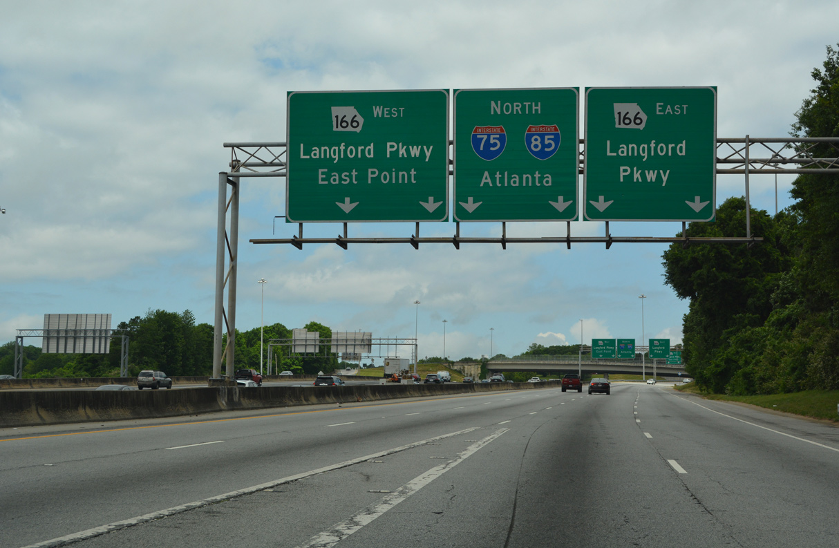
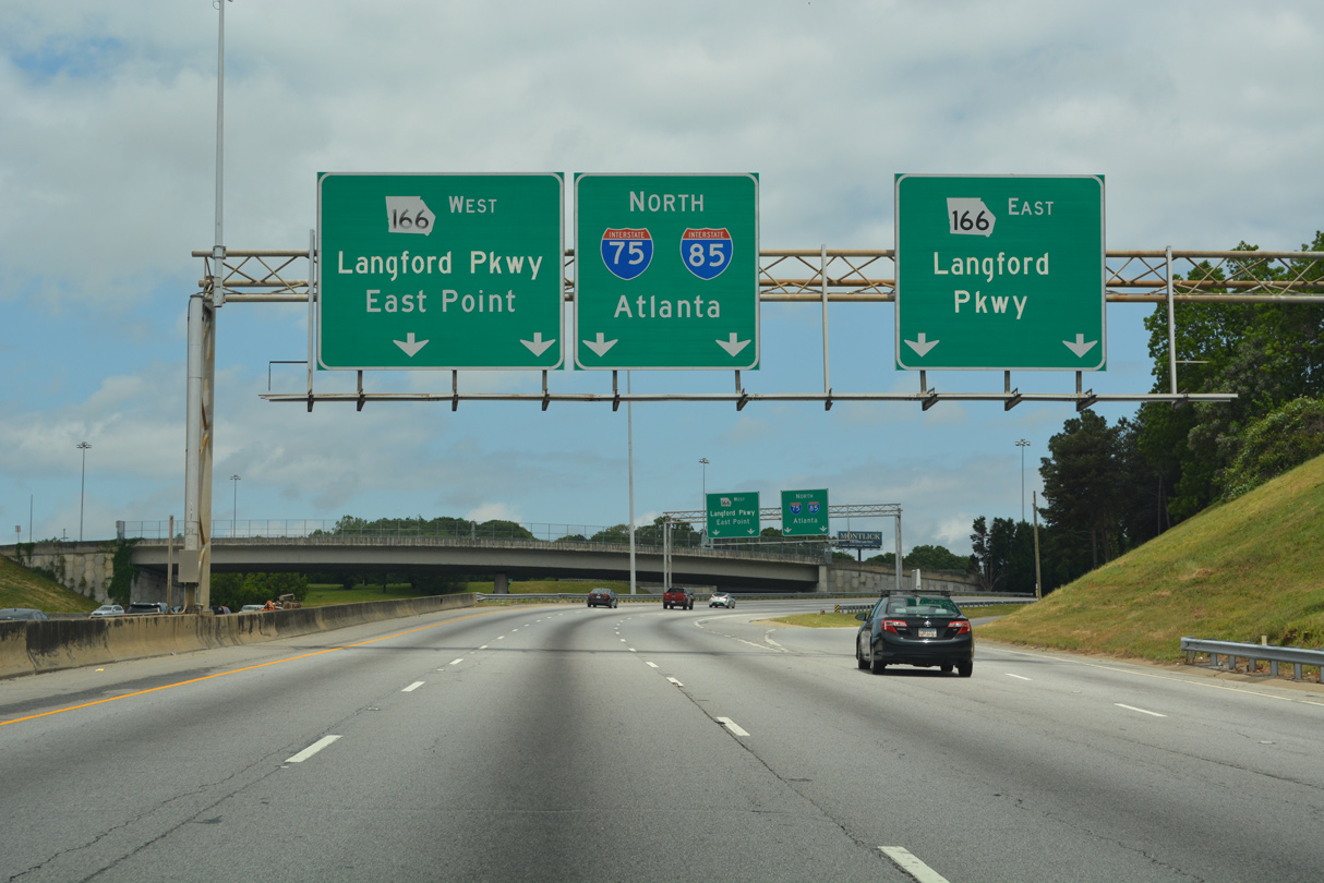
| Interstate 75 continues north with five through lanes and one HOV-2 lane to SR 166 (Langford Parkway). 05/06/22 |
|
| A parclo interchange (Exit 241) with Cleveland Avenue precedes the ramp for SR 166 and merge with Interstate 85 north. 05/06/22 |
|
| Cleveland Avenue heads 4.06 miles out of East Point to Jonesboro Road (SR 54) in southeast Atlanta. The commercial boulevard intersects U.S. 19/41 (Metropolitan Parkway) ahead of ramps with I-85 to the west at Hammond Park. 05/06/22 |
|
| Traffic separates with four lanes advancing north to the Downtown Connector and two for a c/d roadway to the cloverstack interchange with SR 166. Formerly named the Lakewood Freeway, SR 166 was a part of the planned route of Interstate 420, an urban loop between I-285 and I-20 in DeKalb County. 05/06/22 |
|
| Exit 243 leaves I-75 north for SR 166. SR 166 travels 63.57 miles overall from Atlanta to Carrollton and the Alabama state line west of Bowdon. 05/06/22 |
|
| The Downtown Connector begins at the wye interchange where I-75 and I-85 combine. A separate flyover joins the adjacent c/d roadway for Langford Parkway. 04/13/12 |
|
| Two lanes join from I-85 north to expand the c/d roadway to SR 166 (Langord Parkway) to four overall lanes. 05/06/22 |
|
| Langford Parkway spurs 0.32 miles east to Lakewood Avenue at a half diamond interchange. Stub ends there allude to the unconstructed I-420. 05/06/22 |
|
| SR 166 (Langord Parkway) west straddles northern reaches of East Point along a four lane urban parkway. 05/06/22 |
Page Updated 01-27-2024.

 North
North