|
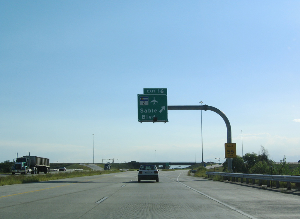
| Back to back trumpet interchanges previously linked I-76/U.S. 6 west with SH 51 (Sable Boulevard) north and SH 2 (historic U.S. 6) to the south. Construction from Summer 1998 to September 2001 consolidated the two exchanges into a single diamond interchange with a realignment of Sable Boulevard.1 09/01/04 |
|
| Truncated north of I-76 in 2010, with Sable Boulevard reverting to city of Brighton maintenance,1SH 2 shields on overheads for Exit 16 were replaced by 2016 with an airport trailblazer. Aside a 0.44 mile section at Exit 16, SH 2 south from I-76 to Rocky Mountain Arsenal National Wildlife Refuge and Commerce City was also decommissioned. SH 2 remains from U.S. 6/85 south to U.S. 285 (Hampden Avenue) in Denver. 09/01/04 |
|
| A replacement of the distance sign preceding the Peoria Street overpass changed Colorado Springs - 82 miles with Grand Junction - 257 miles. 09/01/04 |
|
| SH 44 overlays a 4.96 mile section of 104th Avenue west from SH 2 in Commerce City to Colorado Boulevard in Thornton. The state highway crosses over Interstate 76 just east of U.S. 85 and north of Exit 12. 09/01/04 |
|
| Road work underway from October 2016 to late 2017 / early 2018 improved the westbound curve of I-76/U.S. 6 at the wye interchange (Exit 12) with U.S. 85. With four lanes, U.S. 85 varies as a divided highway, expressway or arterial north from Commerce City to from Brighton, Fort Lupton, Platteville and Greeley. 09/01/04 |
|
| U.S. 85 south combines with I-76/U.S. 6 west to a dumbbell interchange (Exit 11) with 96th Avenue. 09/01/04 |
|
| Ramps at Exit 11 tie into 96th Avenue and the adjacent Brighton Road frontage road system. 96th Avenue west links I-76 with Mckay Road to Thornton and suburban areas north of Rocky Mountain Arsenal National Wildlife Refuge. 09/01/04 |
|
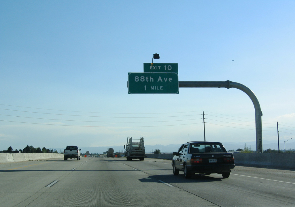
| 88th Avenue crosses Interstate 76 west from the Irondale community of Commerce City at forthcoming Exit 10. 09/01/04 |
|
| West from Exit 10, 88th Avenue takes a causeway like road across the Gravel Lakes and South Platte River, entering Thornton ahead of the Thornton Valley East subdivision and Thornton Mobile Estates. 09/01/04 |
|
| U.S. 6 separates from Interstate 76 at Vasquez Boulevard and Exit 9, 81.5 miles west from where it joined the freeway outside Brush. 09/01/04 |
|
| Vasquez Boulevard takes U.S. 6/85 south through Commerce City to Interstate 70 at Elyria Swansea in Denver. SH 2 briefly accompanies the arterial to the exchange with I-270, before joining Colorado Boulevard south into Northeast Park Hill in Denver. 09/01/04 |
|
| The 5.34 mile section of Vasquez Boulevard south from the wye interchange (Exit 9) with I-76 to Interstate 70 is inventoried by CDOT as Route 006H. This is the last signed section of U.S. 85 until south of Colorado Springs and U.S. 6 west until the 6th Avenue Freeway at Sun Valley, Denver. 09/01/04 |
|
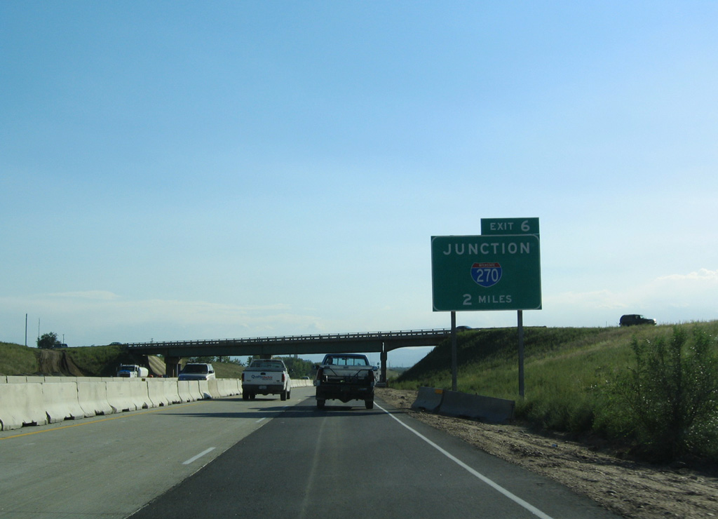
| Dahlia Street spans Interstate 76 two miles ahead of Exit 6 with Interstate 270. The freeway traverses an area of wetlands between Thornton Lakes and the O'Brian Canal over the next mile to SH 244. 09/01/04 |
|
| An entrance ramp adds traffic to I-76 west from SH 244 (74th Avenue) by Engineer Lake. Curving west, travelers cross the South Platte River ahead of Exit 6 for Interstate 270. 09/01/04 |
|
| Completed in 2003, the extension of Interstate 270 west links with I-25 north to Thornton, Northglenn and Fort Collins. 09/01/04 |
|
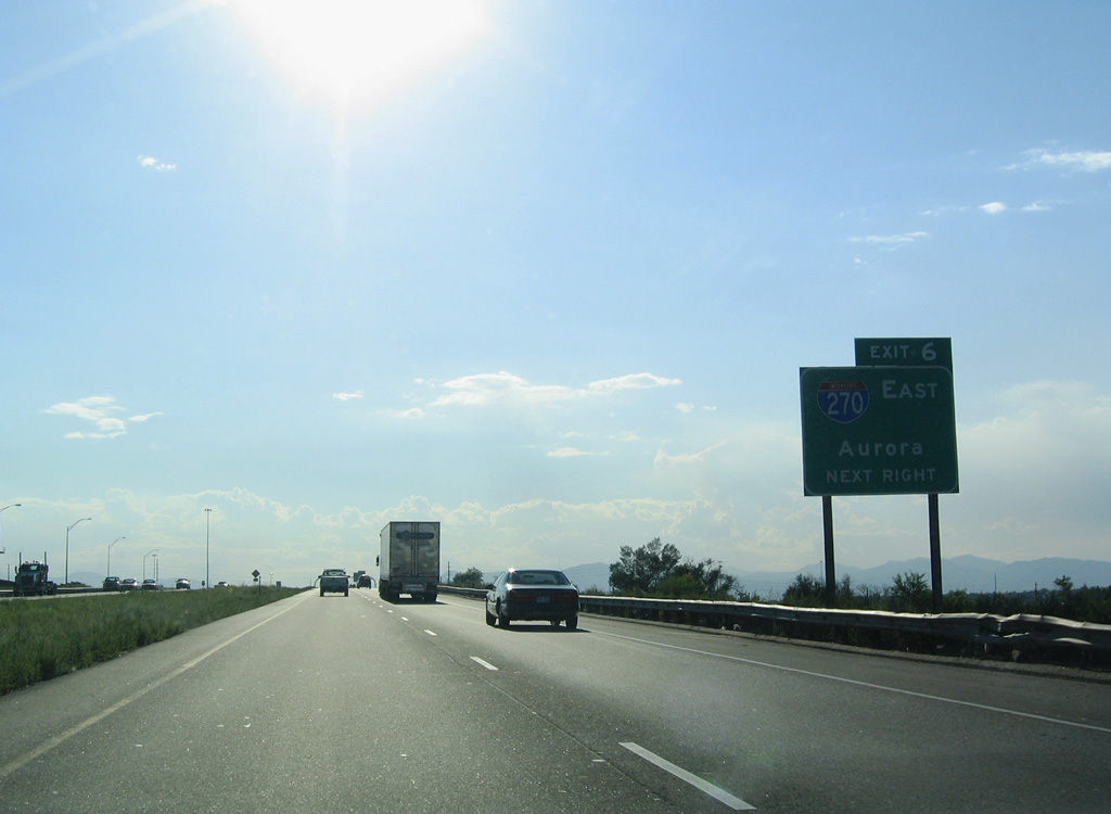
| I-270 constitutes a busy urban loop with just four lanes to U.S. 36 (Denver-Boulder Turnpike) northwest to Boulder and Interstate 70 east to Aurora. 09/01/04 |
|
| A directional cloverleaf interchange with a distributor roadway joins I-76 and Interstate 270 at Exit 6. 09/01/04 |
|
| Exit 6 partitions into ramps for U.S. 36 west to Westminster and Boulder and I-270/U.S. 36 east to Stapleton in Denver and Limon for the continuation of I-70. 09/01/04 |
|
| I-76 proceeds west to meet Interstate 25 at Exit 5A. 09/01/04 |
|
| There is no Exit 5B, as that ramp permanently closed with the completion of I-270 west to I-25 nearby. 09/01/04 |
|
| Paralleling Clear Creek through industrial North Washington, the succeeding exit along Interstate 76 west is with Pecos Street. 09/01/04 |
|
| Ramps from I-25 form a westbound auxiliary lane for Interstate 76 to the diamond interchange (Exit 4) with Pecos Street. 08/15/13 |
|
| This interchange sequence sign outlines the final two mainline exits from Interstate 76 west. Both fall within unincorporated areas of Adams County. 08/15/13 |
|
| Pecos Street heads north to Twin Lakes and Sherrelwood and south into Denver at Chaffee Park. 08/15/13 |
|
| U.S. 287 (Federal Boulevard) heads north from Regis and Chaffee Park in Denver to a diamond interchange (Exit 3) with Interstate 76 by the Westmoreland neighborhood. 08/15/13 |
|
| Interstate 76 spans 60th Avenue, Union Pacific Railroad tracks and an RTD light rail line east of Clear Creek / Federal Station. 08/15/13 |
|
| I-76 west crosses Clear Creek three times over the course of 3.25 miles between U.S. 287 (Federal Boulevard) and the exchange with Interstate 70 and SH 121 (Wadsworth Boulevard). 08/15/13 |
|
| Exit 3 leaves I-76 west for U.S. 287 (Federal Boulevard) south to Denver and north to Westminster and Federal Heights. 08/15/13 |
|
| SH 95 (Sheridan Boulevard) straddles the Jefferson County line north from Lakeside and Regis in Denver to meet Interstate 76 next at Exit 1B. 08/15/13 |
|
| With just four lanes, Interstate 76 advances west from U.S. 287 to pass over Lowell Boulevard. 84,000 vpd were recorded here by CDOT in 2015. 04/23/17 |
|
| Motorists staying on the freeway west of the Wadsworth Boulevard off-ramp reach the I-70 exit for SH 391 (Kipling Street) in north Wheat Ridge in 3.75 miles. 04/23/17 |
|
| Sheridan Boulevard constitutes a five lane urban arterial south along the Denver city and county line to Edgewater, east Lakewood and Yale Avenue, where it wholly enters the city at Bear Valley. SH 95 follows Sheridan Boulevard south to the U.S. 285 freeway and north to U.S. 36 (Denver-Boulder Turnpike) in Westminster. 04/23/17 |
|
| The directional cloverleaf interchange (Exit 269A) joining Interstate 70 and SH 121 (Wadsworth Boulevard) intertwines with ramps from I-76 west and to I-76 east. Wadsworth Boulevard forms a busy commercial arterial north through south Arvada. 04/23/17 |
|
| Completed in 1985, the final 1.6 miles of Interstate 76 curve southwest and nips the corner of the city and county of Denver. 04/23/17 |
|
| Interstate 70 runs west from I-76 through north Wheat Ridge to SH 72 (Ward Road). SH 121 (Wadsworth Boulevard) travels south from the freeway to the Wheat Ridge municipal building. 04/23/17 |
|
| Exit 1A parts ways with the ending Interstate 76 west for SH 121. Two lanes continue west onto Interstate 70 to Golden, Idaho Springs and Grand Junction. 04/23/17 |
|
| Following Wadsworth Boulevard or Parkway, the state highway stretches nearly 31 miles south to Lakewood and Ken Caryl Ranch and north to U.S. 287 in Broomfield. 04/23/17 |
|
| An end shield for Interstate 76 stands within the wye interchange at I-70 in south Arvada. 04/23/17 |
Page Updated 01-12-2022.


 West
West


 South
South