|
| Interstate 95 leaves the New Jersey Turnpike system ahead of the interchange complex with U.S. 46 at Ridgefield Park. U.S. 46 constitutes an east-west surface arterial from South Hackensack to Palisades Park within the vicinity of I-95. 06/26/05 |
|
| Bergen Turnpike (CR 124) passes over Interstate 95 ahead of the ramp departure to U.S. 46. U.S. 46 east combines with U.S. 1/9 north at Palisades Park for a three mile overlap to I-95 at Route 4 and the Palisades Interstate Parkway in Fort Lee. 06/26/05 |
|
| A look at the replaced button copy overheads for I-95 north and U.S. 46 preceding the Bergen Turnpike (CR 124) over crossing. U.S. 46 travels just 75 miles overall between the New York state line on the George Washington Bridge west to Columbia and the Delaware River. 03/15/00 |
|
| Three lanes of the Interstate 95 mainline continue to the U.S. 46 off-ramp at Ridgefield Park. The unnumbered exit partitions to U.S. 46 east to Palisades Park and Ridgefield (via U.S. 1/9 south) and U.S. 46 west to Ridgefield Park and Hackensack. 06/26/05 |
|
| Departing the northbound lanes of Interstate 95 northbound next is the Exit 68 off-ramp to Challenger Road. Challenger Road spurs north from Emerson Street near U.S. 46 to Overpeck County Park. 06/26/05 |
|
| Attached to the Emerson Street overpass is the one mile guide sign for the Exit 70 collector distributor roadway to Degraw Avenue west and Fort Lee Road east.
A dynamic message sign for the George Washington Bridge (GWB) alerts truckers to use the upper deck of the suspension bridge. I-95 north splits into roadways for the upper and lower decks of the GWB in 3,000 feet. 06/26/05 |
|
| Exit 68 leaves Interstate 95 north for the adjacent Challenger Road at Ridgefield Park. To the left is the inner roadway approach to Interstate 80 west. 06/26/05 |
|
| Traffic interests to the Major Deegan Expressway (Interstate 87) should use the lower deck of Interstate 95 north (signed as the local lanes here). Exit 1C departs the Cross-Bronx Expressway in 6.5 miles for Interstate 87. 06/26/05 |
|
| The next sign bridge begins the partition of Interstate 95 north for the lower ( local lanes) and upper (express lanes) decks of the GWB. The variable message portion of the sign illuminates to display the "Best Route to NY" depending upon traffic congestion. The bridge toll plaza is notorious for creating lengthy delays between I-80 and the bridge itself. 06/26/05 |
|
| Exit 70 departs the local lanes of Interstate 95 north ahead of the merge with Interstate 80 east. Degraw Avenue (CR 56) leads east from Teaneck township into the borough of Leonia as Fort Lee Road. 06/26/05 |
|
| The outer roadway widens to four lanes in anticipation of the local and express roadways for the George Washington Bridge. There is a slip ramp near the toll barrier from the local lanes onto the express lanes for trucks that must use the upper deck of the suspension bridge. 06/26/05 |
|
| Former guide signs posted ahead of the three-wye interchange with I-80 west. Traffic utilizing the express roadway sees one final off-ramp (Route 67) before crossing the George Washington Bridge. The Local roadway includes exits for DeGraw Avenue (Teaneck), Broad Avenue (Englewood), and U.S. 9W and Route 4 at Fort Lee. 03/15/00 |
|
| Interstate 95 northbound partitions for a fourth time overall at Interstate 80 in Teaneck township. The Exit 70 c/d roadway also separates from the freeway for Degraw Avenue (Bergen County 56). 06/26/05 |
|
| The inner roadway ramps to Interstate 80 west separate into ramps for the express lanes to Paterson and local lanes to Hackensack. I-80 travels nearly 2,900 miles across country to San Francisco, California. 06/26/05 |
|
| Traffic from the local lanes of I-80 east combines with the local lanes of I-95 ahead of the three quarter cloverleaf interchange (Exits 70A/B) with Degraw Avenue. A collector distributor roadway system joins I-95 with Degraw Avenue (CR 56). Exit 70A serves interests east to Overpeck County Park and Leonia. 08/29/05 |
|
| Exit 70B loops onto Degraw Avenue (CR 56) west through Teaneck township. CR 56 becomes Main Street through the borough of Bogota further west. 08/29/05 |
|
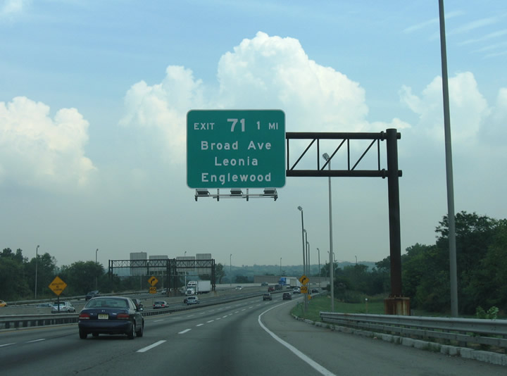
| Next in line for northbound motorists is the Exit 71 loop ramp to Broad and Lakeview Avenues in Leonia. 08/29/05 |
|
| Interstate 95 winds east across Overpeck Creek ahead of the Exit 71 off-ramp to Broad Avenue north to the city of Englewood and Lakeview Avenue west to Grand Avenue (Route 93) in Leonia. 08/29/05 |
|
| The local lanes of Interstate 95 prepare to split with a slip ramp to the express lanes for the upper level of the George Washington Bridge. The signs include movable panels that redirect motorists onto the upper or lower levels depending upon traffic conditions. All commercial truck traffic must merge onto the express lanes for the upper level of the bridge due to their prohibition on the lower deck. 08/29/05 |
|
| The local lanes serve U.S. 46 and Route 4 and at the borough of Fort Lee via Exit 72. U.S. 46 enters Fort Lee with U.S. 1/9 from Palisades Park. Route 4 constitutes an expressway east from Hackensack, Teaneck, and Englewood. 08/29/05 |
|
| A second sign bridge prepares motorists for the George Washington Bridge partition into upper and lower levels. All interests to Exits 72 and 73 are advised to take the outer roadway of Interstate 95 north for Fort Lee. However Exit 73 departs the inner roadway for Route 67 ahead of the George Washington Bridge toll plaza as well.
Drivers destined for Interstate 87 (Major Deegan Expressway) are directed onto the lower level of the George Washington Bridge. 08/29/05 |
|
| One half mile west of the Exit 72 off-ramp to U.S. 9W (Fletcher Avenue) on Interstate 95 north. U.S. 9W begins in Fort Lee from U.S. 1-9-46 and travels northward through Englewood Cliffs, Tenafly, Alpine, and Nyack, New York alongside the Hudson River. Palisades Interstate Parkway parallels U.S. 9W as a limited-access route between Fletcher Avenue, Interstates 87 & 287 (New York Thruway) and points north. The parkway is restricted to passenger vehicles only. 08/29/05 |
|
| Former button copy overheads posted ahead of the wye interchange with the ending Route 4 expressway. This sign represented the last time U.S. 46 was referenced on Interstate 95 guide signs. U.S. 1-9-46 merge onto Interstate 95 east of Fletcher Avenue (U.S. 9W). 03/15/00 |
|
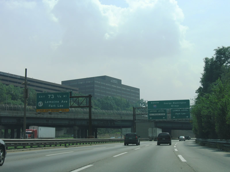
| Exit 73 represents the last exit before the George Washington Bridge from both roadways of Interstate 95. The off-ramp from the inner roadway to Route 67 departs after the slip ramp from the outer roadway. 08/29/05 |
|
| Route 4 east crosses over Interstate 95 ahead of the outer roadway split into lanes for both the upper and lower levels of the GWB. The state route concludes a 10.83 mile route with ramps onto the both roadways of Interstate 95 and Fletcher Avenue (U.S. 1-9-9W-46). 08/29/05 |
|
| The local lanes of Interstate 95 partition into roadways for the upper and lower decks of the George Washington Bridge ahead of the Exit 72 off-ramp to U.S. 9W (Fletcher Avenue). 08/29/05 |
|
| A left side off-ramp carries motorists onto Fletcher Avenue in Fort Lee. U.S. 9W follows Fletcher Avenue north from U.S. 1-9-46 to Lemoine Avenue through Coytesville. Fletcher Avenue doubles as a direct connection to the Palisades Interstate Parkway northbound for West Nyack, New York. 08/29/05 |
|
| U.S. 1-9-46 south pass over the local lanes of Interstate 95 one half mile west of the Exit 73 off-ramp to Route 67 (Lemoine Avenue). The Route 4 eastbound ramp to Fletcher Avenue (U.S. 9W) is visible to the right.
Route 67 travels southward 1.86 miles from U.S. 9W and the Palisades Interstate Parkway to Route 5 (Central Avenue) in Fort Lee. 08/29/05 |
|
| Northbound at the Fletcher Avenue over crossing on the local lanes of Interstate 95. U.S. 1-9-46 merge onto the local lanes from Bergen Boulevard the left. Exit 73 to Route 67 (Lemoine Avenue) departs in one quarter mile to the right. 08/29/05 |
|
| With U.S. 1-9-46 now on board, the local lanes of Interstate 95 prepare to split with ramps to Route 67 (Exit 73) and the upper level (for trucks entering the freeway from U.S. 1-9-46). Linwood Avenue passes over the freeway here. 08/29/05 |
|
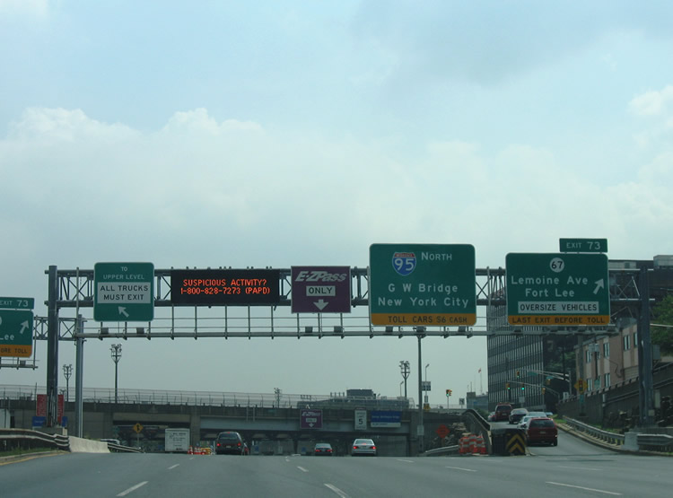
| Exit 73 ascends onto the adjacent northbound side frontage road (Bruce Reynolds Boulevard) at Center Avenue as the slip ramp to the upper level of the George Washington Bridge departs from the left. Route 67 (Lemoine Avenue) crosses paths with the frontage street in two blocks between Fletcher Avenue (U.S. 9W) and Main Street (CR 56). 08/29/05 |
|
| The lower level toll plaza for the George Washington Bridge lies just east of the Center Avenue overpass in Fort Lee. Variable toll rates are charged in the eastbound direction while the westbound direction is free. Rates increase during peak hours and for those paying in cash. Cash rates have increased from $6.00 for passenger vehicles in 2004 to $13.00 in 2014. 08/29/05 |
|
| Interstate 95 north begins a slow descent toward the lower level of the George Washington Bridge beyond the toll plaza. Attached to the Route 67 (Lemoine Avenue) overpass is a guide sign indicating the I-95 connections with Interstate 87 (Major Deegan Expressway), New England, and Long Island (via Interstate 295 south). 08/29/05 |
|
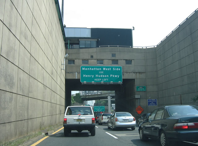
| The first New York City interchange along Interstate 95 joins the freeway with Henry Hudson Parkway (NY 9A) on Manhattan Island. NY 9A straddles the western shore of the island from Lower Manhattan north to the Henry Hudson Bridge over the Harlem River. 08/29/05 |
|
| Ramps overhead carry Palisades Interstate Parkway southbound traffic onto the upper level of the George Washington Bridge. Bergen County 505 (Hudson Terrace) passes in between. Interests to Manhattan's East Side should use the second New York City exit for Franklin D. Roosevelt Drive / Harlem River Drive. 08/29/05 |
|
| Descending below the upper level of the George Washington Bridge along I-95 north between the Palisades Interstate Parkway loop ramp and the suspension bridge. 08/29/05 |
|
| A left side off-ramp departs the lower level of the George Washington Bridge for NY 9A (Henry Hudson Parkway) at the east end of the span. Henry Hudson Parkway comprises a limited-access highway from West 57th Street in Midtown Manhattan to a transition into the Saw Mill River Parkway in the Bronx. 08/29/05 |
|
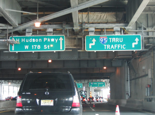
| U.S. 9 departs I-95/U.S. 1 via Exit 1 onto 178th Street east to Broadway north. U.S. 9 follows Broadway north from the Cross-Bronx Expressway through Washington Heights and Inwood on Manhattan Island to Kings Bridge in the Bronx. 08/29/05 |
|
| Interests to the Major Deegan Expressway (Interstate 87) should keep to the right for the eventual Exit 1C off-ramp from the Alexander Hamilton Bridge. The Alexander Hamilton Bridge carries I-95 across the Harlem River. 08/29/05 |
|
| New York state welcome sign posted between the north and southbound travel lanes of the GWB lower deck. The state line officially marks the eastern terminus of U.S. 46. 08/29/05 |
|
| Three lanes of I-95/U.S. 1 north travel the lower deck of the George Washington Bridge. Posted shortly after the New York state line is a diagrammatic sign for the Exit 1 split between the Cross Bronx Expressway mainline and ramps to 178th Street east (U.S. 9 north) and NY 9A (Henry Hudson Parkway). 08/29/05 |
|
| Interstate 95 and U.S. 1 share pavement from Fort Lee, New Jersey east to Exit 2B (Webster Avenue) in the Bronx. Several small guide signs reference the U.S. 1 overlap with Interstate 95 along the George Washington Bridge and Cross Bronx Expressway. 08/29/05 |
|
| Two through lanes continue beyond the Exit 1 ramp split with NY 9A (Henry Hudson Parkway) and U.S. 9 north (178th Street east). Henry Hudson Parkway constitutes a north-south limited-access freeway between 57th Street in Manhattan and Saw Mill River Parkway in Yonkers. The parkway, like other New York State Parkways, is open to passenger vehicles only. 08/29/05 |
|
| Exit 1 leaves the lower deck of the George Washington Bridge for ramps to 178th Street east and the Henry Hudson Parkway north and south. U.S. 9 parts ways with I-95/U.S. 1 via 178th Street east to Broadway. NY 9A follows Henry Hudson Parkway south to West Street and Battery Park at FDR Drive and Interstate 478. 08/29/05 |
|
| There is little room for error on Interstate 95 northbound at the gore point for Exit 1 (NY 9A and U.S. 9 north). 08/29/05 |
|
| Exit 1 descends from the George Washington Bridge toward its split with ramps to NY 9A and the continuation of U.S. 9 north onto 178th Street east. U.S. 9 follows Broadway north from Manhattan Island through the Bronx, Yonkers, Hastings-on-Hudson, Dobbs Ferry, Irvington, and Tarrytown. 08/29/05 |
|
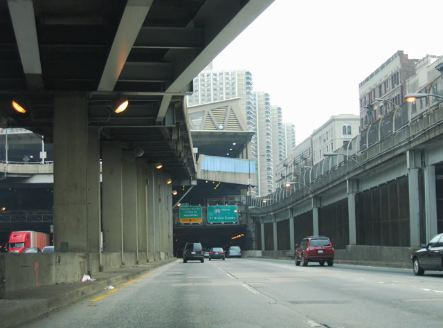
| The lower deck of the George Washington Bridge transitions into the outer roadway of the Cross Bronx Expressway eastbound. Interstate 95 emerges from the shadows above briefly before entering a series of tunnels under a transit station and various buildings. 08/29/05 |
|
| Departing the freeway next is the left side off-ramp of Exit 2 to Harlem River Drive. Harlem River Drive parallels the eastern shore of Manhattan Island between FDR Drive and 10th Avenue. FDR Drive comprises a freeway from Harlem Drive Drive south to Midtown and Lower Manhattan. 08/29/05 |
|
| Exit 2 serves Amsterdam Avenue and University Avenue, via the Washington Bridge, in addition to Harlem Drive Drive and FDR Drive. Amsterdam Avenue travels north-south alongside High Bridge Park; University Avenue leads north from the High Bridge section of the Bronx to Kings Bridge Heights. 08/29/05 |
|
| One quarter mile ahead of the ramp departure (Exit 20 to Harlem River Drive for Franklin D. Roosevelt Drive southbound. Exit 3 signs advise motorists of forthcoming interchange with Interstate 87 (Major Deegan Expressway) through this stretch. 08/29/05 |
|
| One final set of signs precede the separation of Exit 2 along Interstate 95 north. Ramps split from Exit 2 for the Washington Bridge across the Harlem River to University Avenue north and Edward L. Grant Highway south, and Amsterdam Avenue at 175th Street. 08/29/05 |
|
| The inner and outer roadway ramps to Harlem River Drive combine at the Amsterdam Avenue overpass on I-95/U.S. 1 north. Two through lanes continue from both roadways onto the Alexander Hamilton Bridge over the Harlem River. 08/29/05 |
Page Updated 04-15-2014.

 North - outer roadway through Ridgefield Park