|
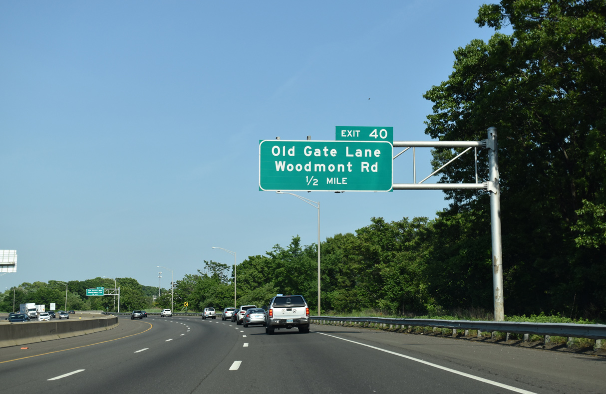
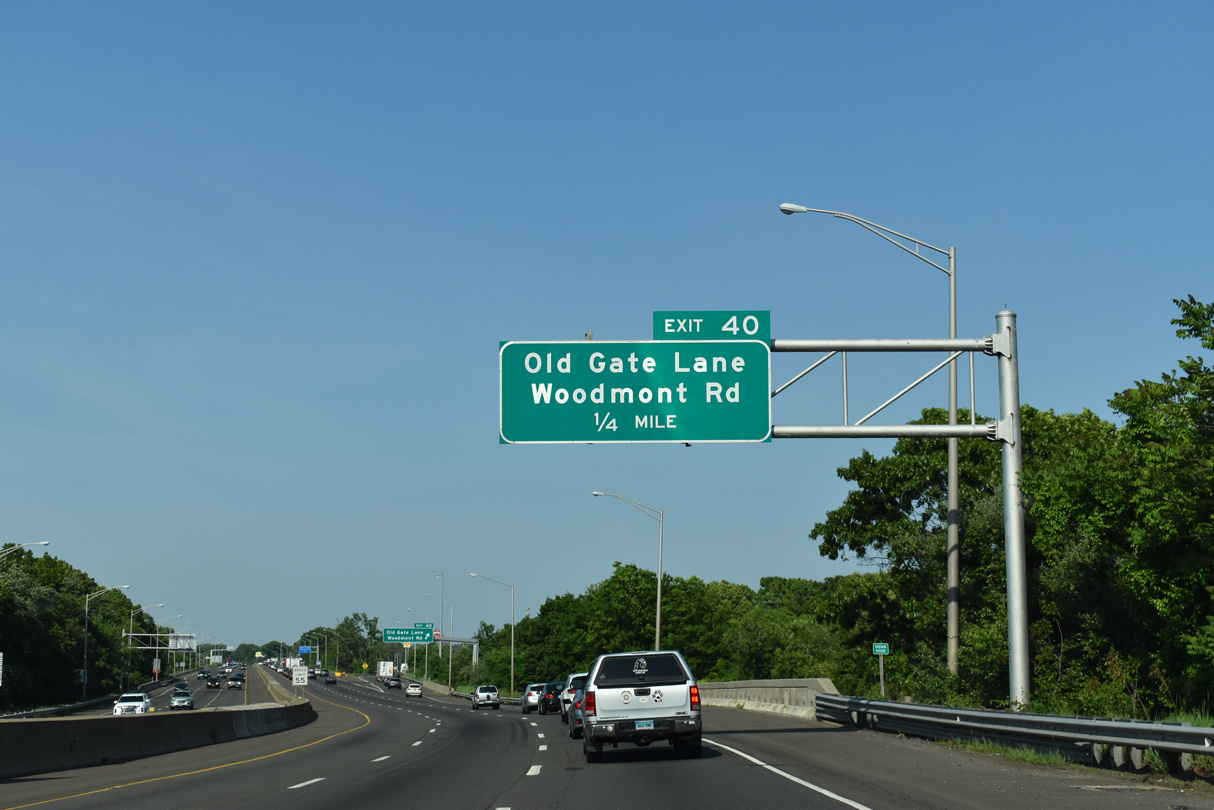
| Exit 40 connects I-95 with Old Gate Lane (Route 708) east 0.32 miles to Woodmont Road in east Milford. Old Gate Lane heads southwest 0.80 miles to Route 162 (New Haven Avenue). 05/30/22 |
|
| Interstate 95 curves northeast across the Indian River by this shield assembly. 05/30/22 |
|
| Town Road passes under I-95 a quarter mile from Exit 40 to Old Gate Lane. Town Road links Old Gate Lane with U.S. 1 (Boston Post Road) at Connecticut Post Mall. 05/30/22 |
|
| Woodmont Road stems south from Roses Mill Road near U.S. 1 (Boston Post Road) 0.94 miles to Anderson Avenue and Pepps Farm Road near the Woodmont community. 05/30/22 |
|
| The Milford Service Area is next along Interstate 95 north. 05/30/22 |
|
| Quarry Road spans Interstate 95 beyond this confirming marker. 05/30/22 |
|
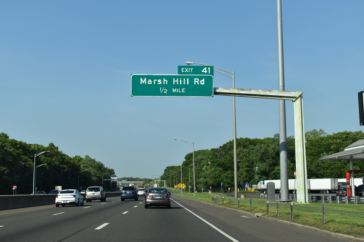
| Marsh Hill Road extends 0.98 miles north from Oxford Road and the Milford city limits to Lambert and Indian River Roads by the Christmas Tree Shops retail complex in Orange. 05/30/22 |
|
| Located south of Indian Lake, the Milford Service Plaza offers travelers the opportunity to refuel, eat and acquire tourist information. 05/30/22 |
|
| Indian Hill Road provides a cut off from Marsh Hill Road north to Route 114 (Racebrook Road). Route 114, and Route 152 (Orange Center Road) to the west, both travel north from U.S. 1 (Boston Post Road) in Orange to Route 34 (Derby Turnpike). 05/30/22 |
|
| South from Exit 41, Marsh Hill Road to Oxford Road joins I-95 with east Milford and the city of West Haven. 05/30/22 |
|
| Interstate 95 proceeds northeast from the parclo interchange at Exit 41 across the Oyster River. 05/30/22 |
|
| Having paralleled I-95 northeast from U.S. 1 in Milford, Route 162 finally meets Governor John Lodge Turnpike at Exit 42. Route 162 dog legs west from Main Street in West Haven along Saw Mill Road to Exit 42 and Bull Hill Lane. 05/30/22 |
|
| Route 162 loops northwest from the parclo interchange at Exit 42 to U.S. 1 (Boston Post Road) in the town of Orange. 05/30/22 |
|
| Route 162 (Saw Mill Road) east to Main Street leads to the West Haven city center. Exit 42 was originally a parclo B2 interchange. 05/30/22 |
|
| Campbell Avenue meets I-95 at a half diamond interchange (Exit 43) north of Downtown West Haven and a half mile south of Route 122 (1st Avenue). 05/30/22 |
|
| Route 122 follows Campbell Avenue north to U.S. 1 (Orange Avenue) and Forest Road at Allingtown. The 3.51 mile long route travels from Exit 44 along I-95 southbound to Route 63 (Whalley Avenue) in northwest New Haven. 05/30/22 |
|
| Stevens Avenue spans I-95 just ahead of Exit 43 to Campbell Avenue and Route 122. The ramp to Campbell Avenue descends 70 feet in elevation along a bluff line. 05/30/22 |
|
| Campbell Avenue extends 2.28 miles south from Route 122 through West Haven to Captain Thomas Boulevard and Savin Rock condominiums along Long Island Sound. 05/30/22 |
|
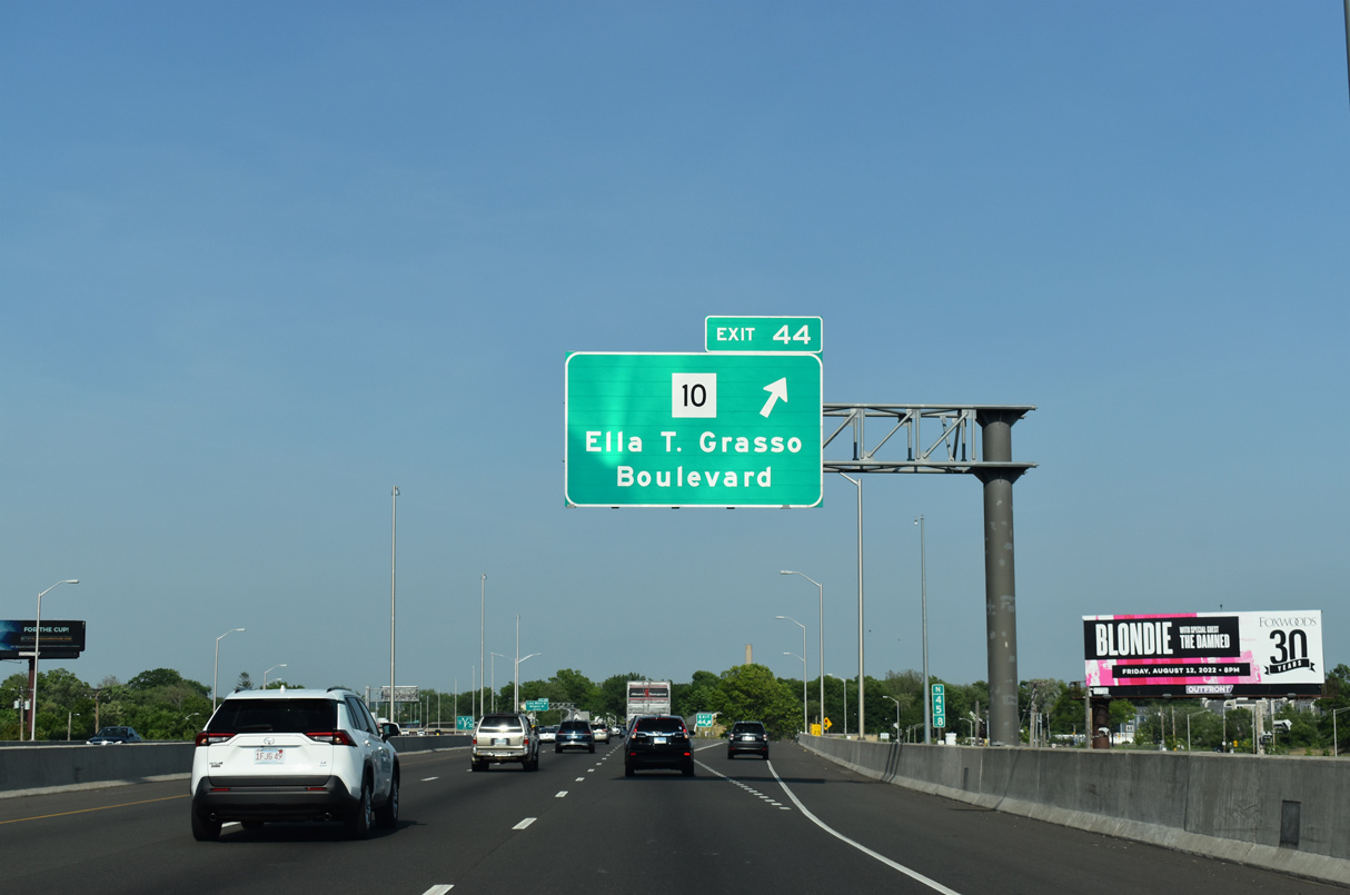
| Interstate 95 continues east across Route 122 (1st Street) to a modified diamond interchange (Exit 44) with Route 10 (Ella T. Glasso Boulevard). Route 10 constitutes a 262 mile long multi state highway through Connecticut, Massachusetts and New Hampshire. 05/30/22 |
|
| Heading north to Edgewood Park and Westville within the city of New Haven, MSR 10 begins at Kimberly Road (Route 745) just west of Exit 44. 05/30/22 |
|
| Crossing the West River, Interstate 95 north enters the city of New Haven. Exit 44 previously consisted of a pair of loop ramps with Kimberly Road directly adjacent to a trumpet interchange with Route 10 (Ella T. Glasso Boulevard). 05/30/22 |
|
| Route 745 follows Kimberly Avenue northeast to Route 10 (Ella T. Glasso Boulevard) and west across the mouth of the West River onto 1st Avenue in West Haven. 05/30/22 |
|
| Turning northeast along New Haven Harbor, RIRO ramps at Exit 46 join northbound I-95 with parallel Long Wharf Drive at Vietnam Veterans Memorial Park and southbound with Sargent Drive. 05/30/22 |
|
| The I-95 New Haven Harbor Crossing Corridor Improvement Program rebuilt and expanded Interstate 95 from Exit 46 / Long Wharf Road across the Q Bridge to Exit 54 / Cedar Street. Work got underway on April 28, 2010 and was completed in 2017. 05/30/22 |
|
| I-95 proceeds north into the Mixmaster Interchange (Exits 47/48) with Interstate 91 and MLK Boulevard (Route 34) west to Downtown New Haven beyond Exit 46. Relocated a quarter mile to the west, the new ramp for the Long Wharf Drive/Sargent Drive frontage road system opened in 2011. 05/30/22 |
|
| Left exit ramps for both Route 34 (MLK Boulevard) and I-91 north were replaced with flyovers departing from the outside lanes as part of the I-95 New Haven Harbor Crossing Corridor Improvement Program. 05/30/22 |
|
| Route 34 follows the couplet of MLK Boulevard and S Frontage Road through Downtown New Haven. Previously Route 34 took Richard C. Lee Connector to York Street. Formerly known as the Oak Street Connector, the freeway spur opened to traffic in 1960.1 05/30/22 |
|
| Interstate 91 commences north to Meriden from I-95 at Exit 48. Paralleling U.S. 5 north to the capital city of Hartford, I-91 extends northward to Springfield, Massachusetts, Brattleboro, Vermont and the Canadian border south of Sherbrooke, Quebec. 05/30/22 |
|
| The relocated Exit 48 to Interstate 91 north from I-95 north opened to traffic on July 16, 2016.
05/30/22 |
|
| Interstate 95 north curves southeast from the Mixmaster Interchange to Exit 50 in East Haven over the Q Bridge spanning the Quinnipiac River and the north end of New Haven Harbor. 05/30/22 |
|
| Known as the New Haven Harbor Crossing Pearl Harbor Memorial Bridge, or locally as the Q-Bridge, the original bridge opened to traffic in 1958. Starting in 2007, work commenced on first of two extradosed cable stayed bridges replacing the aging six lane span. 05/30/22 |
|
| Completed in 2012, traffic completely shifted from the 1958 bridge onto the new span with two-way traffic on July 29, 2013. Crews then demolished the original span to make way for the new southbound bridge, which initially opened in September 2015.2,3 05/30/22 |
|
| Approximately 60,000 vehicles a day (vpd) spanned the mouth of the Quinnipiac River in 2005. The I-95 New Haven Harbor Crossing
Corridor Improvement Program addressed traffic growth and the need for safety improvements.2 111,100 vpd crossed the ten lane Q Bridge in 2020. 05/30/22 |
|
| Permanently closed in 2007, a half diamond interchange (Exit 49) with Stiles Avenue tied into the east end of the Q Bridge. This exchange was dismantled during the bridge replacement project and replaced with new ramps at Exit 50. 05/30/22 |
|
| Exit 50 connects Interstate 95 with Route 337 (Townsend Avenue) south to the U.S. Coast Guard Station - New Haven, Fort Nathan Hale and Tweed New Haven Airport (HVN). Part of a 20 acre city park, Fort Nathan Hale played a role in the Revolutionary War, the War of 1812 and the Civil War. 05/30/22 |
|
| The Q Bridge spans part of the New Haven Port Area east to Exit 50. Lighthouse Point lies at the south end of New Haven where the waters of New Haven Harbor meet Long Island Sound. 05/30/22 |
|
| Route 741 (Main Street) stems east from Exit 50 at Woodward Avenue 0.09 miles to Route 337 (Townsend Avenue). Route 337 forms a 4.91 mile long loop south from U.S. 1 (Forbes Avenue) in New Haven to Silver Sands Road and Route 142 in East Haven. 05/30/22 |
|
| Exit 50 partitions with a loop along Waterfront Connector (Route 921) west 0.23 miles to Fulton Terrace and Waterfront Street in the New Haven Port Area. 05/30/22 |
|
| I-95 drops below grade ahead of Woodward Avenue and the split diamond interchange (Exit 51) with adjacent U.S. 1 along Forbes Avenue and Frontage Road. 05/30/22 |
|
| Exit 51 joins U.S. 1 (Frontage Road) northbound ahead of Route 100 (High Street) and Route 142 (Hemingway Avenue). Route 100 joins the East Haven city center with U.S. 1 and Route 80 at Foxon to the north. Route 142 loops south to Short Beach in Branford. 05/30/22 |
|
| I-95 previously reduced to four overall lanes east of Exit 51, but widening associated with the I-95 New Haven Harbor Crossing Corridor Improvement Program extended the six lane portion east to Exit 54 between 2004 and mid 2009.2 A slip ramp provides return access from the eastbound Frontage Road as U.S. 1 north shifts southward toward Beacon Hill. 05/30/22 |
|
| Completion of the Interstate 95 expansion through the town of East Haven occurred by mid 2006. The freeway enters the town of Branford across Lake Saltonstall and ahead of Exit 53 for the Branford Connector (Route 794). 03/23/23 |
|
| Branford Connector (Route 794) joins I-95 with U.S. 1 between Route 142 (Short Beach Road) and Route 146 (Main Street). Route 142 arcs southwest from U.S. 1 (W Main Street) to the communities of Double Beach and Short Beach. 03/23/23 |
|
| Providing options for food, fuel and tourist information, the Branford Service Area lies just beyond the wye interchange at Exit 53. 03/23/23 |
|
| Exit 53 parts ways with I-95 north a half mile east of the Holssey Avenue overpass. 1.05 miles long, Branford Connector ties into U.S. 1 just west of the N Main Street separation with Main Street (Route 146). 03/23/23 |
|
| The Branford Service Area was renovated between April 2012 and September 2013. 03/23/23 |
|
| Exit 53 departs Interstate 95 north for Branford Connector south to U.S. 1 (W Main Street) and Route 146 east to the Branford town center. Route 146 comprises a 13.00 mile long loop east to U.S. 1 in Guilford. 03/23/23 |
|
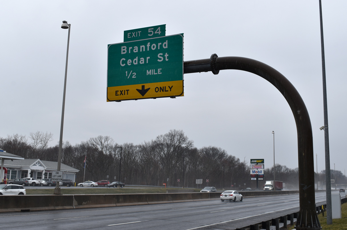
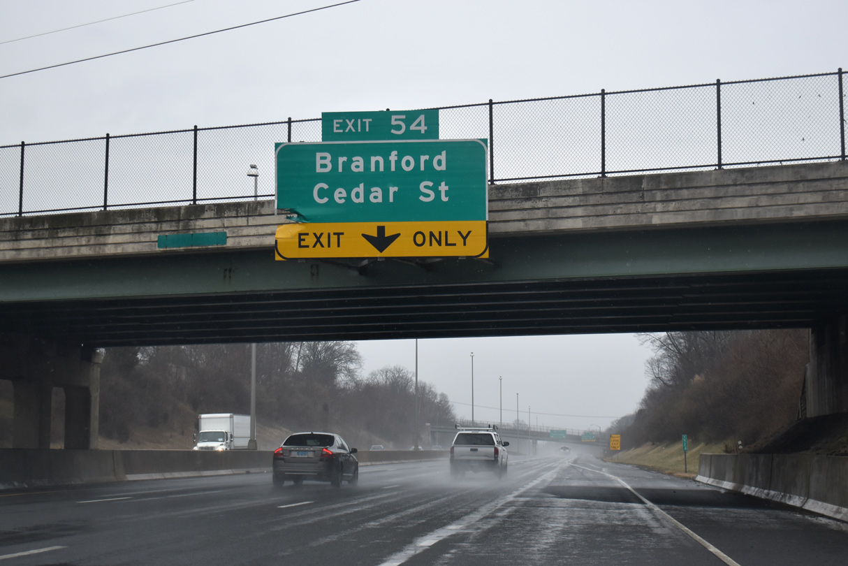
| Following the Branford Service Area, Interstate 95 advances 0.75 miles to Exit 54 for Cedar Street (Route 740) north of Branford Center. 03/23/23 |
|
| Interstate 95 reduces to four overall lanes east of the diamond interchange (Exit 54) with Cedar Street. Route 740 extends 3.22 miles north from parallel U.S. 1 (N Main Street) to Route 80 at Totoket in North Branford. 03/23/23 |
|
| Cedar Street extends 0.46 miles south from U.S. 1 (N Main Street) to Route 146 (Main Street) west of Brandford Town Hall. 03/23/23 |
|
| Exit 54 leaves Interstate 95 northbound for Cedar Street south and Brushy Plain Road north. 03/23/23 |
|
| Northbound reassurance marker posted east of the Ivy Street underpass. 03/23/23 |
|
| U.S. 1 (N Main Street) overtakes E Main Street en route from central Branford to the parclo B2 interchange at Exit 55. 03/23/23 |
|
| U.S. 1, in conjunction with Route 139 (North Branford Road), provides a route to the North Branford town center from Interstate 95. Route 139 runs 2.36 miles northeast to Route 22/80. 03/23/23 |
|
| U.S. 1 (E Main Street) meets the south end of Route 139 (North Branford) just east of Exit 55. U.S. 1 diverges from I-95 north to Route 22 by Moose Hill and returns to Governor John Lodge Turnpike at Exit 57. 03/23/23 |
|
| The succeeding exit along northbound Interstate 95 is for Leetes Island Road. 03/23/23 |
|
| Leetes Island Road heads 1.82 miles south from U.S. 1 (E Main Street) to Route 146 (Stoney Creek Road) near the community of Stoney Creek. 03/23/23 |
|
| School Ground Road extends 0.54 miles north from Leetes Island Road and U.S. 1 (E Main Street) to Route 139 (N Branford Road) along the North Branford town line. 03/23/23 |
Page Updated 04-23-2023.

 North
North