Interstate 295 extends 4.23 miles east through the town of North Attleborough from Cumberland, Rhode Island to complete its beltway route around Providence. The freeway within Massachusetts was completed in 1969, with the connection west into the Ocean State following in 1975.1 I-295 carries six overall lanes.
The east end of I-295 consists of a partially used full cloverleaf interchange with Interstate 95 at Attleboro. Provisions here were made for Interstate 895, the 1966 proposed east half of the Providence beltway leading south to I-195 at Swansea. Community opposition led to the cancellation of that route by 1971.1
|
| A reassurance marker appears for Interstate 295 north a short distance east of the Rhode Island state line in a forested area by Abbott Run. 07/28/07 |
|
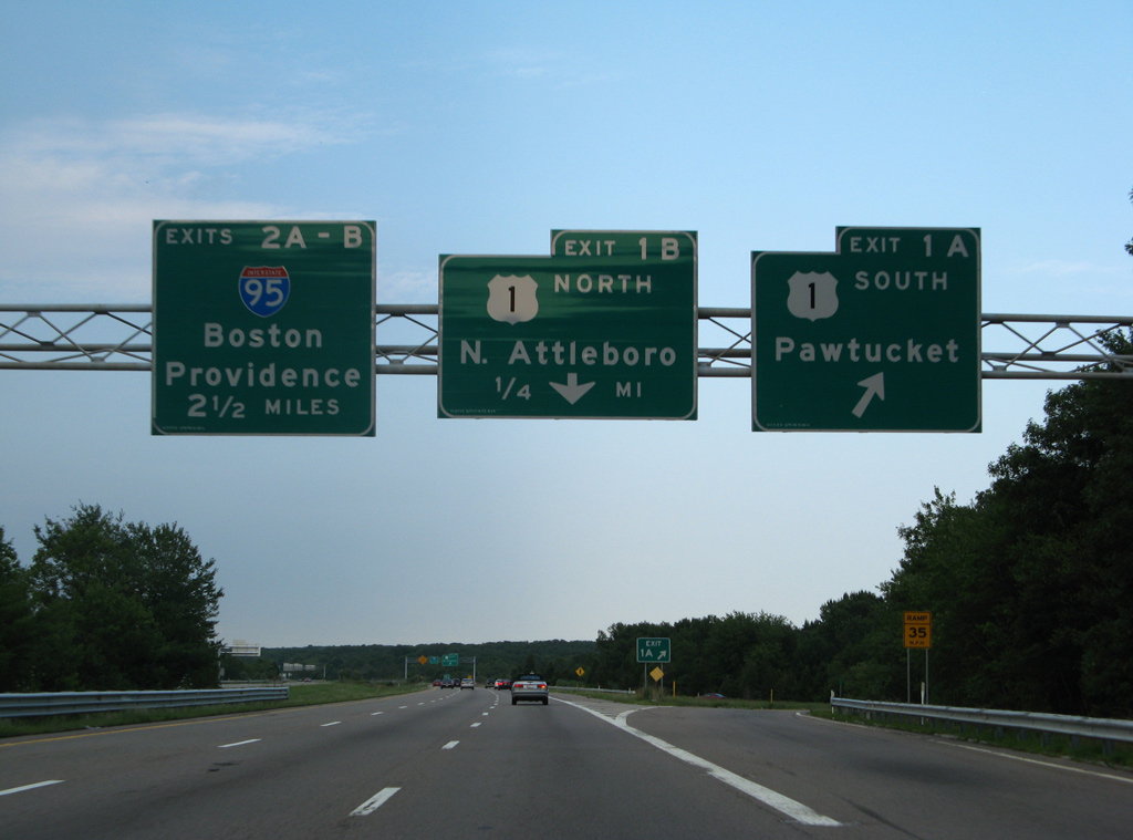
| U.S. 1 heads north from Pawtucket, Rhode Island to South Attleborough and a cloverleaf interchange (Exits 1A/B) with Interstate 295. 07/28/07 |
|
| Exit 1A departs in one half mile for U.S. 1 south to adjacent Emerald Square Mall and other nearby retail along Washington Street. U.S. 1 partitions with Route 1A (Newport Avenue) ahead of South Attleborough. 07/28/07 |
|
| U.S. 1 (Washington Street) crosses paths with Interstate 95 in 3.5 miles ahead of the state line into Pawtucket. The North Attleboro town center lies three miles to the north along South Washington Street.
Replacements made at Exit 1A by 2008 included the removal of the advance sign for I-95 (Exits 2A/B). 07/28/07 |
|
| Two miles remain along Interstate 295 north to I-95 while Exit 1B joins U.S. 1 (Washington Street) north. U.S. 1 bypasses the North Attleboro business district to the east en route to Plainville and Exit 34 of I-495.
New signs posted here by 2008 include Boston and Providence for I-95. 07/28/07 |
|
| The final shield assembly for Interstate 295 north stands beyond the Old Post Road under pass. 07/28/07 |
|
| An end sign precedes the conclusion of Interstate 295 by 1.25 miles. 07/28/07 |
|
| Single lane ramps (Exits 2A/B) join Interstate 95 south to Providence, Rhode Island and north to Boston in one mile.
A new diagrammatic overhead replaced these separate panels for Exits 2A/B by 2009. 07/28/07 |
|
| There is no direct connection from I-295 into Attleboro, but both directions of I-95 serve the town via adjacent interchanges. Had I-895 been completed, motorists would have continued ahead onto the beltway south for Attleboro. 07/28/07 |
|
| Interstate 295 north passes to the north of Manchester Pond on the half mile approach to Exit 2A for Interstate 95 south. I-95 straddles the west side of Attleboro before winding southwest into Pawtucket, Rhode Island.
These signs were replaced by 2009. 07/28/07 |
|
| Exit 2A leaves the ending I-295 north for I-95 south to the Rhode Island capital city. Exit 2B follows for the 37 mile drive to Boston. 07/28/07 |
|
| Chevron striping appears as the two lane roadway for I-295 reduces to a single through lane. 07/28/07 |
|
| I-295 crosses the Tenmile River ahead of this regulatory sign cautioning motorists of the freeway end in 1,000 feet. 07/28/07 |
|
| A mere formality at this point as all motorists default onto the loop ramp for I-95 north, an overhead referenced Exit 2B for I-95 north. This sign was replaced by 2012 and now includes a large sweeping arrow and no control city. 07/28/07 |
|
| Milepost four appears at the wide overpass for I-295 north above I-95. The two lane mainline was to extend east as the beginning of I-895 south. 07/28/07 |
|
| Concrete barriers separate the departing loop ramp for I-95 north from unused pavement of the short stub for I-895 south. 07/28/07 |
|
| A companion stub exists along the southbound roadway. 07/28/07 |
|
| Massachusetts often signs the beginnings and ends of Interstate highways with shield assemblies such as this one posted on Interstate 295 southbound. The freeway begins at a parclo interchange with Interstate 95 northwest of the Attleboro town center. The interchange includes ghost ramps for the unconstructed Interstate 895 freeway between Attleboro and Seekonk. 06/26/05 |
|
| The first regular reassurance shield for Interstate 295 southbound appears just west of the begin assembly. The freeway maintains six lanes from Attleboro westward to Woonsocket, Rhode Island. 06/26/05 |
|
| The first interchange, and only in Massachusetts, joins Interstate 295 with U.S. 1 (Washington Street) near Emerald Square Mall. U.S. 1 parallels Interstate 95 through South Attleborough, North Attleborough and Plainville locally. 06/26/05 |
|
| A cloverleaf interchange joins Interstate 295 and U.S. 1 (Washington Street) at Exits 1B/A. Pictured here is the northbound off-ramp to Washington Street to the North Attleboro town center.
This set of signs was replaced by 2009 as the pull through panel for I-295 was removed. 06/26/05 |
|
| Exit 1A leaves Interstate 295 southbound for U.S. 1 (Washington Street) south for west Attleboro and Pawtucket, Rhode Island. U.S. 1 crosses Interstate 95 just north of the state line, 4.25 miles to the south.
A replacement made at Exit 1A by 2008 included a horizontal rule for the exit tab. 06/26/05 |
|
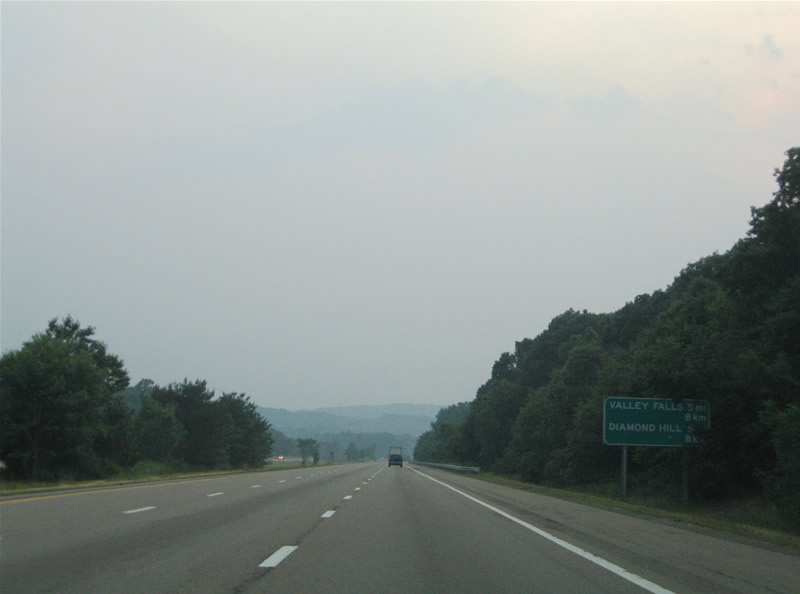
| This sign posted just west of U.S. 1 lists the distances to the Rhode Island communities of Diamond Hill and Valley Falls. The two communities lie along RI 114 just west of the Massachusetts state line. 06/26/05 |
|
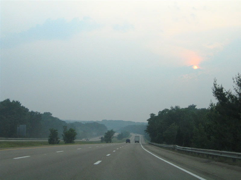
| The waning sun sheds light along a stretch of Interstate 295 near the state line. The freeway maintains a wide median and right of way throughout its entire routing. 06/26/05 |
|
| Nearing the state line and Exit 11 (Route 114) on Interstate 295 south. Route 114 (Diamond Hill Road) travels north-south between Newport and Woonsocket in eastern Rhode Island. The state route follows Diamond Hill Road through the town of Cumberland.
This sign was replaced by 2008. 06/26/05 |
|
| Welcome to Rhode Island sign posted beyond the state border along Interstate 295 south at the Abbott Run Valley Road under crossing. 06/26/05 |
Page Updated 06-20-2006.


 North
North