
Arrow map showing Interstate 485 and SR 410 in Atlanta.
Interstate 485 was considered for three separate corridors in metropolitan Atlanta in the 1960s and 1970s. Per various municipal planning documents they were:1
- State Route 410 Corridor - from I-75/85 eastward to Interstate 285 at Exit 39A by Clarkston. This included the westernmost section of the Stone Mountain Freeway (U.S. 78).
- Western State Route 410 Corridor - from I-75/85 eastward to a planned extension of I-675/SR 400.
- Combination of the Western SR 410 and Northern SR 400 Corridors - from I-75/85 eastward on an arc to Interstate 85 near the vicinity of Lenox Road.
Eventually the proposal for a 5.5 mile long loop from I-75/85 (Downtown Connector) to I-85 at Buckhead where the south end of SR 400 is today, was approved by the American Association of State Highway Officials (AASHO) on June 30, 1970.
The short freeway spur along SR 10 east from Downtown Atlanta to Howell Street was constructed for I-485/SR 410 in the 1960s. It included a partial interchange with an entrance ramp from Boulevard westbound and a loop ramp from eastbound to parallel Houston Street (John Wesley Dobbs Avenue) at Howell Street.
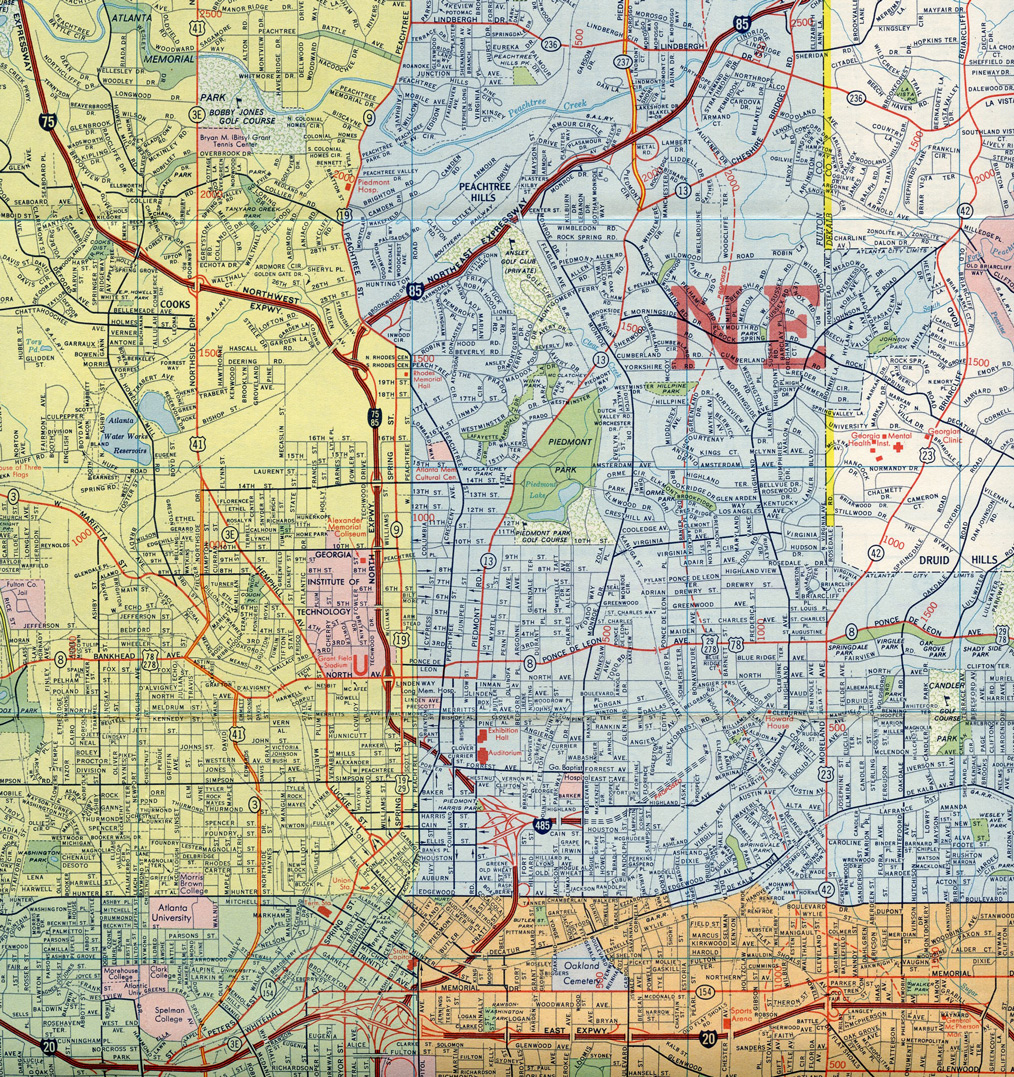
Interstate 485 along the short spur from I-75/85 east to Boulevard in 1969

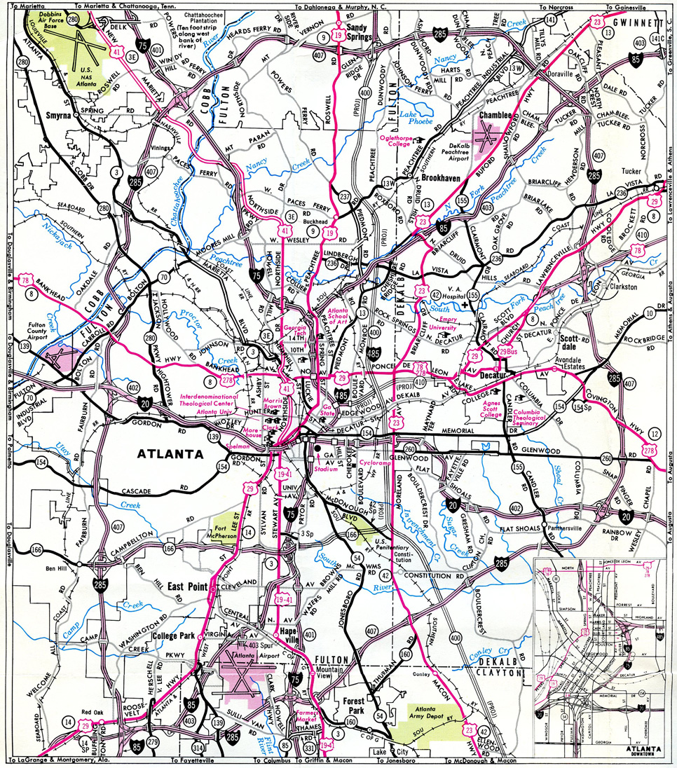
The full proposals for I-485, SR 400 and SR 410 for Atlanta in 1969.
As construction for Interstate 485 continued eastward during the tenure of Governor Jimmy Carter, neighborhood opposition arose. A construction contract extending the freeway east moved forward under Carter. However community protests increased, with some residents going so far as to chain themselves to construction equipment to prevent road work. The objections eventually resulted in the cancellation of I-485, and a final administrative change renumbered the route from SR 410 to SR 10, ending any consideration for this corridor as part of the Interstate Highway System.1
Interstate 485 on the 1971 Official Georgia Highway Map
The Georgia Department of Transportation requested the withdrawal of I-485 to the Federal Highway Administration (FHWA) on January 16, 1975 as part of a substitution for three alternate Interstate Routes in accordance with the provisions of 23 U.S.C. 103(e)(2). This eliminated I-485 and added I-175 between Albany and Cordele, I-420 from I-75/85 east to I-20 in Atlanta, and I-675 from I-75 to I-285 southeast of Atlanta. The American Association of State Highway and Transportation Officials (AASHTO) subsequently eliminated Interstate 485 on June 17, 1975.
Using the right of way acquired for Interstate 485, construction eventually commenced in the 1990s for Freedom Parkway and the Jimmy Carter Presidential Library. Associated work replaced the overpass for Boulevard with an at-grade intersection. Where The Carter Center is located, by the junction of SR 10 (John Lewis Freedom Parkway) with the eastern leg of Freedom Parkway along SR 42CO, was where a multi level interchange would have been built had the I-485 and the Stone Mountain Tollway (SR 410) been completed.1
- J.T. Legg. Cancelled Atlanta Freeway Projects.
http://peachstateroads.tripod.com/ atlanta/atlfwys_canceled.html
Connect with:
State Route 10
State Route 400 - Turner McDonald Parkway
Page Updated 03-25-2022.