|
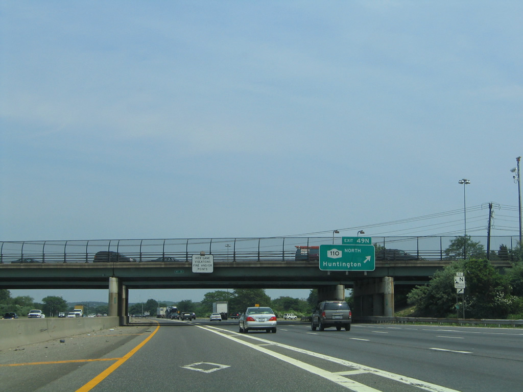
| Exit 49S joins South Service Road east ahead of both Walt Whitman Road and NY 110 (Broad Hollow Road) to provide access to Amityville. Originally a conventional cloverleaf joined I-495 with the state route, but three of the four non-loop ramps were removed from the service roads near Broad Hollow Road to reduce weaving traffic patterns on the L.I.E. 06/13/05 |
|
| NY 110 heads south from Exit 49S through Melville to Republic Airport (FRG) and an end at NY 27A at Amityville. 06/13/05 |
|
| The 15.8 mile long route of NY 110 concludes northward from Exit 49N at Youngs Hill Road in Halesite. 06/13/05 |
|
| Generally a commercial route, NY 110 connects Interstate 495 with South Huntington, Huntington Station and the Huntington town center before ending at Halesite alongside Huntington Harbor. 06/13/05 |
|
| Exit 50 with Bagatelle Road is the first of two interchanges for the Dix Hills community along Interstate 495 east. 06/13/05 |
|
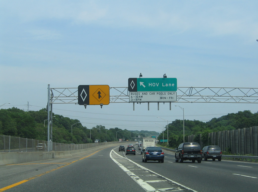
| Motorists can access the HOV lane after the Half Hollow Road overpass. 06/13/05 |
|
| A diamond interchange links Interstate 495 and Bagatelle Road via the Service Roads. Bagatelle Road leads south from Half Hollow Road and Dix Hills to become Conklin Street en route to Wyandanch. 06/13/05 |
|
| HOV traffic approaches the egress point for Exit 51 and NY 231 (Deer Park Avenue) next. 06/13/05 |
|
| NY 231 travels 9.05 miles from NY 27A (Montauk Highway) in Babylon to Northern State Parkway in Dix Hills. The state route crosses paths with Interstate 495 at a diamond interchange (Exit 51) in one mile. 06/13/05 |
|
| Interstate 495 east traverses the Half Hollow Hills at the HOV egress point for NY 231 (Deer Park Avenue). 06/13/05 |
|
| Exit 51 leaves Interstate 495 east for South Service Road ahead of NY 231 at Dix Hills. Heading south, NY 231 joins the L.I.E. with the town of Deer Park. 06/13/05 |
|
| The first sign for Sagtikos Parkway appears after Exit 51 for its course southward to Southern State Parkway at Robert Moses Causeway. Robert Moses Causeway connects the Long Island mainland with Ocean Parkway west to Oak Beach and an end at Fire Island. 06/13/05 |
|
| Continuing through Dix Hills, Interstate 495 passes by the next ingress point for the HOV lane. 06/13/05 |
|
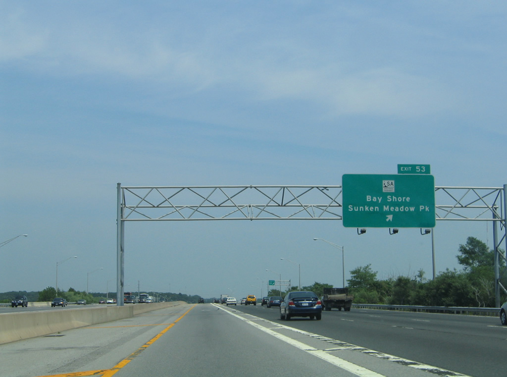
| Interstate 495 passes under Carls Straight Path ahead of a parking area and the HOV egress point for Exits 52 and 53. Exit 53, and Exits 55 through 57 serve the Hauppauge area. 06/13/05 |
|
| A series of ferries link the Long Island mainland with Fire Island. Exit 53 connects I-495 with the Bay Shore-Fire Island ferry via Exit 53 (5th Avenue). 06/13/05 |
|
| The next eastbound exit departs in one half mile for Suffolk County 4 (Commack Road) south to North Babylon and north to Commack. Suffolk County routes are signed throughout the exits of Interstate 495, unlike those in Nassau County which are all unsigned routes. 06/13/05 |
|
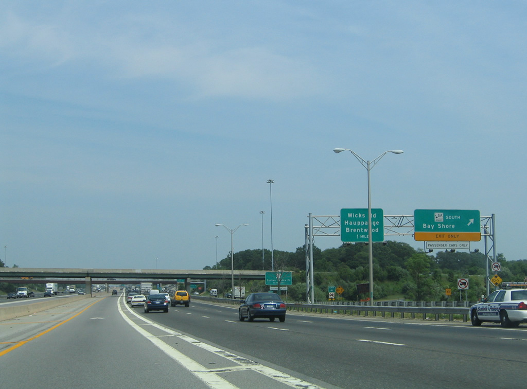
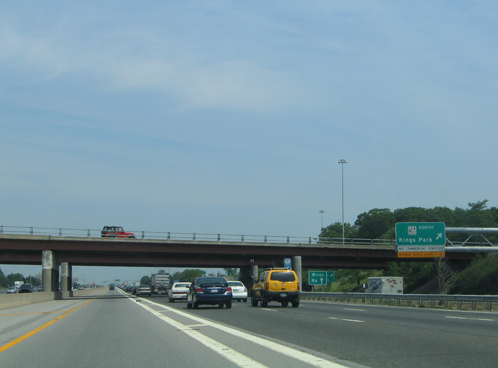
| South Service Road transitions into a collector distributor roadway for the directional cloverleaf interchange with Sagtikos Parkway. The 5.1 mile parkway ventures north from Interstate 495 to become Sunken Meadow Parkway en route to Kings Park.
Beyond the ramp for Sagtikos Parkway, the c/d roadway splits with Express Drive South (frontage road) and a ramp for Wicks Road (Suffolk County 7) to Brentwood. 06/13/05 |
|
| Exit 52 to County Road 4 (Commack Road) leaves Interstate 495 east as the Exit 53 c/d roadway prepares to depart for Sagtikos Parkway. Sign changes made by 2011 switched Sunken Meadow Park to Kings Park for Sagtikos Parkway north. 06/13/05 |
|
| Sagtikos State Parkway was constructed between 1949 and 1952 to link the Northern and Southern State Parkways.1 06/13/05 |
|
| A temporary sign was placed ahead of the southbound ramp for Brentwood, Bay Shore and West Islip. Overheads are now in place here. 06/13/05 |
|
| Drivers depart the Exit 53 c/d roadway for Sagtikos Parkway south to Heckscher State Parkway east for East Islip. The ramp for Wicks Road (CR 7) south to Brentwood and north to Wicks Road departs in one mile. 06/13/05 |
|
| Sunken Meadow Parkway takes over for Sagtikos in one mile at Northern State Parkway to extend the parkway to Sunken Meadows State Park on Long Island Sound. 06/13/05 |
|
| The Sagtikos Parkway connection with Northern State Parkway east leads drivers to NY 347 & 454 (Veterans Memorial Highway) through Hauppauge. 06/13/05 |
|
| Ingress and egress points for the HOV lane lie ahead of the return of the Exit 53 c/d roadway along Interstate 495 east. 06/13/05 |
|
| Express Drive South splits with the c/d roadway ahead of its intersection with Washington Avenue south to Brentwood. 06/13/05 |
|
| Motorists bound for East Brentwood (Exit 55) and Hauppauge (Exit 56) departs the HOV lane ahead of the Washington Avenue overpass. 06/13/05 |
|
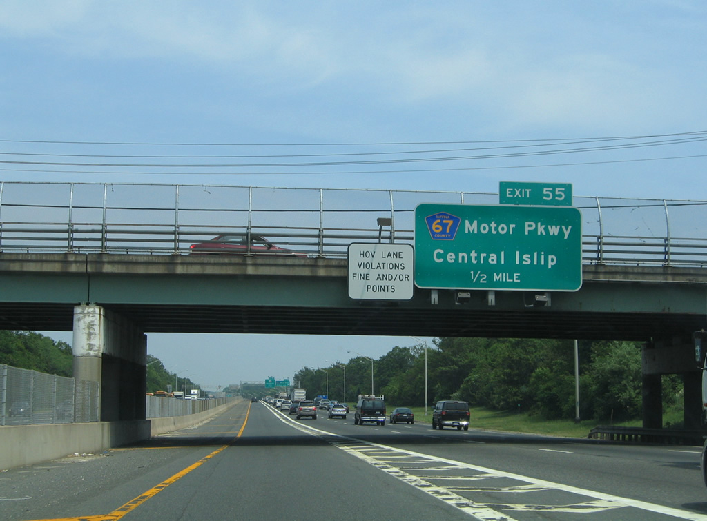
| Suffolk County 67 parallels Interstate 495 east along Motor Parkway from Wicks Road (CR 7) to cross the Long Island Expressway at Exit 55. The county road loops south of the L.I.E. through Central Islip before shifting back northward at Exit 57. 06/13/05 |
|
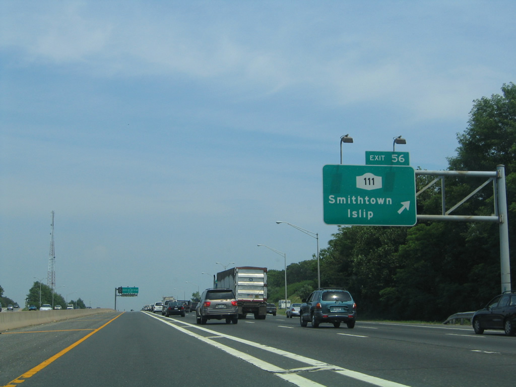
| Exit 55 serves a sprawling industrial park area alongside Motor Parkway (CR 67) west to Moreland Road and east to NY 111 (Joshuas Path). NY 111 angles northeast from Islip Avenue to meet Interstate 495 at Exit 56. 06/13/05 |
|
| NY 111 takes Wheeler Road north from Exit 57 to junction NY 454 (Veterans Memorial Highway), where it becomes Hauppauge Road to NY 25 & 25A (Main Street) at Village of the Branch. South of I-495, the state route concludes at NY 27A (Main Street) in Islip. 06/13/05 |
|
| The next HOV egress point, which exists at the NY 111 under crossing, provides access to the I-495 mainline ahead of Exits 57 through 60. 06/13/05 |
|
| NY 454 constitutes a 13.7 mile route southeast from NY 25 (Jericho Turnpike) at Commack through Hauppauge to NY 27 (Sunrise Highway), west of Patchogue. A split diamond interchange joins Interstate 495 with NY 454 (Veterans Memorial Highway) and Motor Parkway (CR 67) at Exit 57. 06/13/05 |
|
| NY 454 passes under Interstate 495 at an HOV ingress point. 06/13/05 |
|
| Replaced button copy sign posted one mile west of the diamond interchange (Exit 58) with Old Nichols Road. 06/13/05 |
|
| Old Nichols Road angles northeast from NY 454 and Suffolk County 100 (Suffolk Avenue) through the village of Islandia to become Nichols Road, at Terry Road, en route to Nesconset. 06/13/05 |
|
| Interstate 495 leaves Islandia for Ronkonkoma at Connetquot Brook by this reassurance marker. 06/13/05 |
|
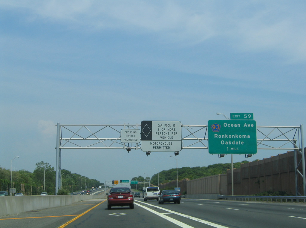
| Suffolk County 93 follows Ocean Avenue south to Lakeland Avenue and north to Rosevale Avenue within the vicinity of Exit 59 through Ronkonkoma. 06/13/05 |
|
| County Road 93 leads southeast along Lakeland Avenue from Ronkonkoma to end at NY 27 (Sunrise Highway), east of Oakdale. Lakeland Avenue continues south from there into Sayville, which is linked to Fire Island National Seashore via a passenger ferry. 06/13/05 |
|
| Exit 59 leaves Interstate 495 east onto Express Drive South to Ocean Avenue. Rosevale Avenue carries CR 93 northwest from Ocean Avenue around Lake Ronkonkoma to its end at Smithtown Boulevard (CR 16). 06/13/05 |
|
| A split diamond interchange (Exit 60) with Ronkonkoma Avenue (CR 29) and Hawkins Avenue is next along Interstate 495 east. 06/13/05 |
|
| Ronkonkoma and Hawkins Avenues lead north from the L.I.E. to Portion Road (Suffolk County 16) in Lake Ronkonkoma. Southward County Road 29 lines Ronkonkoma and Smithtown Avenues south to CR 93 (Lakeland Avenue) west of Long Island Mac Arthur Airport (ISP). 06/13/05 |
|
| The on-ramp from Hawkins Avenue merges onto Interstate 495 east opposite the HOV lane egress point for Exits 61 (Holbrook) and 62 (Holtsville). 06/13/05 |
|
| Suffolk County 19 (Patchogue-Holbrook Road) angles southeast from County Road 16 (Portion Road) at Lake Ronkonkoma to cross paths with Interstate 495 at a diamond interchange (Exit 61) in one half mile. 06/13/05 |
|
| South from Exit 61, County Road 19 continues through Holbrook to an end at Suffolk County 65 in the village of Patchogue. 06/13/05 |
|
| Expressway Drive South (frontage road) connects Exit 61 with Holbrook Road north to the community of Centereach. An HOV lane ingress point precedes the Exit 61 off-ramp otherwise. 06/13/05 |
|
| Eastbound Interstate 495 at the Suffolk County 19 (Patchogue-Holbrook Road) off-ramp (Exit 61). 06/13/05 |
|
| Suffolk County 97 (Nicolls Road) travels between County Road 85 (Montauk Highway) by Blue Point and NY 25A at Stony Brook. The county road meets Interstate 495 at a cloverleaf interchange (Exit 62) in one half mile. 06/13/05 |
|
| County Road 97 exists as a controlled access expressway or arterial throughout its 14.3 mile route. 06/13/05 |
|
| Exit 62 utilizes Expressway Drive South as a c/d roadway for Suffolk County 97 south to Blue Point and north to Suffolk County Community College and SUNY Stony Brook. 06/13/05 |
|
| The final egress point of the HOV lane joins the Interstate 495 eastbound mainline ahead of Exits 63 (Farmingville) and 64 (Medford). 06/13/05 |
|
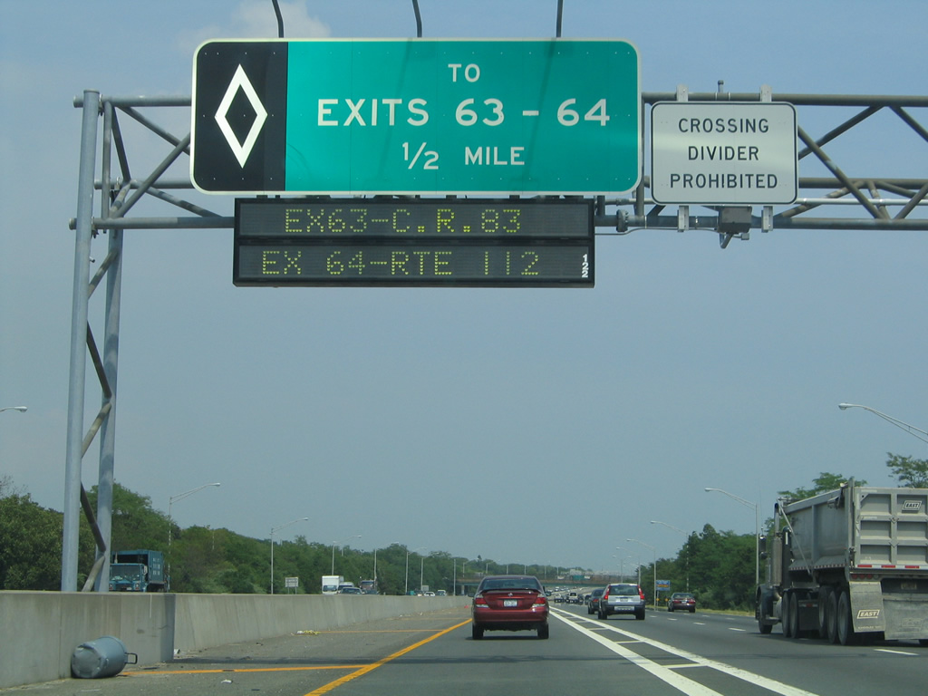
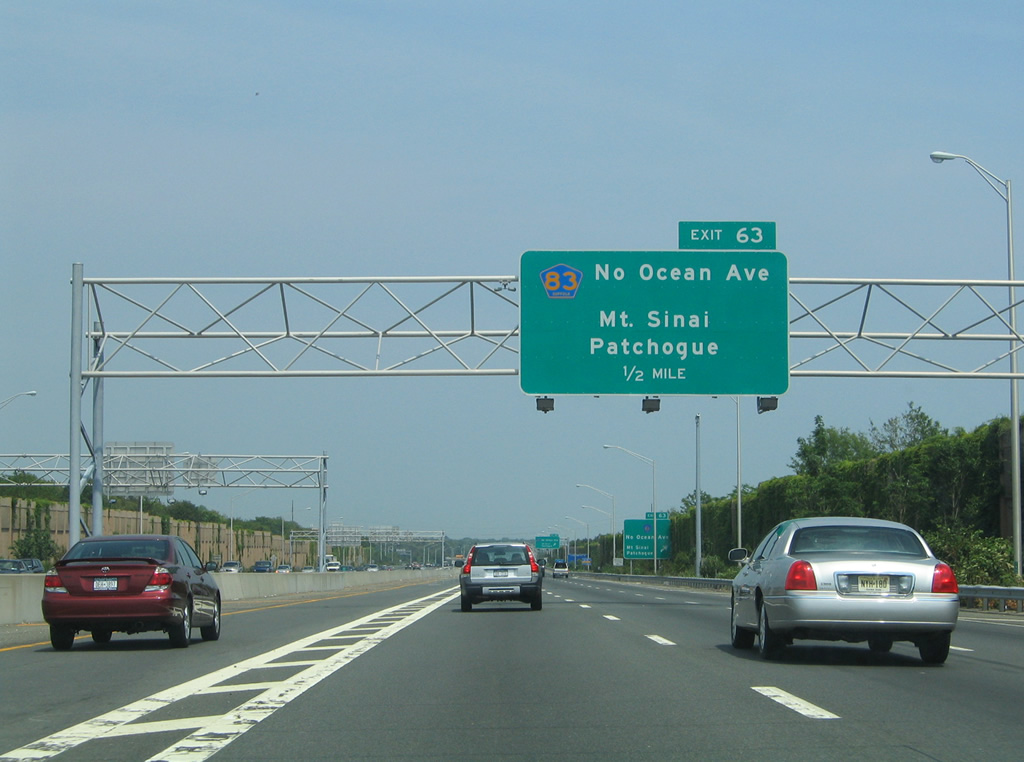
| Suffolk County 83 (North Ocean Avenue) constitutes a divided arterial northward from upcoming Exit 63 to its end at NY 25A at Mt. Sinai. 06/13/05 |
|
| Four lanes of Interstate 495 east near the diamond interchange (Exit 63) with CR 83 (Ocean Avenue). CR 83 measures 11.6 miles in length from NY 27 in North Patchogue to NY 25A. 06/13/05 |
|
| Exit 63 parts ways with Interstate 495 east onto Expressway Drive South to North Ocean Avenue. County Road 83 north ended at Granny Road in Farmingville originally. The extension to Mt. Sinai was constructed between 1971 and 1972.2 06/13/05 |
|
| Two ferries connect Long Island with the state of Connecticut. The Bridgeport-Port Jefferson Ferry launches from West Broadway, near the turn of NY 25A from Main Street onto Broadway in Port Jefferson, NY. The Bridgeport ferry landing resides south of downtown.
The second (Cross Sound) Ferry links the east end of NY 25 at Orient Point with Groton, Connecticut via Exit 70 of I-495. 06/13/05 |
|
| The HOV lane of Interstate 495 east concludes ahead of the diamond interchange (Exit 64) with NY 112. 06/13/05 |
|
| Exit 64 joins Interstate 495 with NY 112, a 12.5 mile north-south route between Patchogue (Main Street) and Port Jefferson Station (NY 25A). 06/13/05 |
|
| NY 112 leads north from Interstate 495 at Medford to the community of Coram, where the route crosses paths with NY 25 (Middle Country Road). 06/13/05 |
|
| Eastbound Interstate 495 at the Exit 64 off-ramp onto Expressway Drive South for NY 112 north to the village of Port Jefferson and the ferry to Bridgeport and south to the village center of Patchogue. 06/13/05 |
|
| The HOV lane transitions into a general purpose lane as Interstate 495 reduces from an eight lane freeway to six lanes east of Exit 64. 06/13/05 |
|
| CR 16 parallels Interstate 495 eastward from Lake Ronkonkoma and Centereach along Portion Road east to Farmingville, where the route shifts southward along Horse Block Road to Exit 65. 06/13/05 |
|
| Entering the diamond interchange (Exit 65) with CR 16 (Horse Block Road) along I-95 east. CR 16 continues southeast along Horse Block Road to NY 27 (Sunrise Highway), west of Shirley, and CR 80 (Montauk Highway) at Brookhaven. 06/13/05 |
|
| A set of weigh stations line Interstate 495 along the stretch between Exits 65 and 66, southwest of Seigfield Park. 06/13/05 |
|
| CR 101 angles northeast along Patchogue-Yaphank Road / Sills Road from CR 80 at East Patchogue to a diamond interchange (Exit 66) with Interstate 495 in one half mile. 06/13/05 |
|
| North from Exit 66, CR 101 concludes at parallel Long Island Avenue, which leads east to Yaphank. 06/13/05 |
|
| NY 27, which travels the length of Long Island from I-278 in Brooklyn to Montauk Point State Park, stays south of I-495 along a combination of arterial and limited access roadways. The easternmost reaches of I-495 diverges from the course of NY 27 toward Riverhead while NY 27 stays eastward to Southampton. Connections between the two freeways include CR 46 (Exit 67), CR 111 (Exit 70) and NY 24 (Exit 71). 06/13/05 |
|
| What was previously a split diamond interchange between CR 101 and CR 21 was made into two separate diamond interchanges.
Exit 67 provides access to CR 21 (Yaphank Avenue) north to Main Street through Yaphank and south to Horse Block Road (CR 16) in Brookhaven. Exit 67 also serves the Suffolk County Offices. 06/13/05 |
|
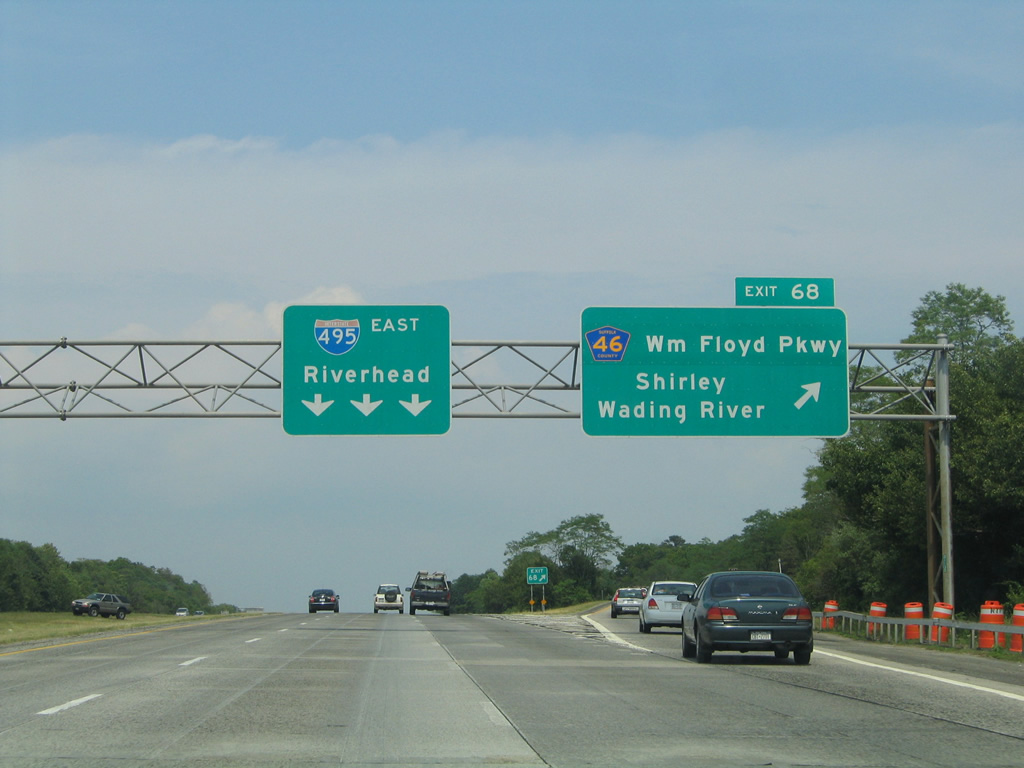
| Meeting Interstate 495 next is CR 46 (William Floyd Parkway) at a cloverleaf interchange (Exit 68) in one half mile. 06/13/05 |
|
| CR 46 runs 17.3 miles from CR 75 at Fire Island National Seashore northward to NY 25A at East Shoreham. 06/13/05 |
|
| Exit 68 parts ways with Interstate 495 east for a collector distributor roadway to William Floyd Parkway south to Brookhaven Airport, Shirley and Smith Point Park on Fire Island. 06/13/05 |
|
| CR 46 (William Floyd Parkway) leads north from Exit 68 to Brookhaven National Laboratory, Wading River and Wildwood State Park (via NY 25A east). 06/13/05 |
|
| Interstate 495 becomes vastly more rural as it enters the Long Island Pine Barrens Region from County Road 46 eastward to Riverhead. 06/13/05 |
|
| Wading River Road crosses paths with Interstate 495 at a diamond interchange (Exit 69) in 0.75 miles. The local road heads north from the L.I.E. as Schultz and Wading River Manor Roads to NY 25 (Middle County Road) at Wading River. 06/13/05 |
|
| South from Exit 69, Wading River Road meanders 4.1 miles southward from Interstate 495 near South Manor to Railroad Avenue in Center Moriches.
County Road 111 (Captain Daniel Roe Highway) starts at forthcoming Exit 70 in 1.25 miles. 06/13/05 |
|
| Interstate 495 (Long Island Expressway) east maintains three lanes eastward to Manorville and CR 111. 06/13/05 |
|
| CR 111 constitutes a 4.8 mile long link between Interstate 495 and NY 27 (Sunrise Highway) at Exit 62. 06/13/05 |
|
| Exit 70 leaves Interstate 495 east for CR 111 (Captain Daniel Roe Highway) east to NY 27 at Eastport and Eastport Manor Road west to Ryerson Avenue. A stub exists at the diamond interchange between CR 111 and NY 27 for a proposed extension southeast to CR 71 (Old Country Road) at Westhampton. 06/13/05 |
|
| The 3.5 mile long stretch east from Exit 70 is the longest without any exits along Interstate 495. 06/12/21 |
|
| Halsey Manor Road passes over Interstate 495, four miles from the east end of the Long Island Expressway. 06/12/21 |
|
| Motorists bound for the eastern points of Long Island are directed to NY 24 east from Exit 71 to NY 27 in Montauk or NY 25 east from the freeway end (Exit 73) to Orient. 06/13/05 |
|
| NY 24 stems east from I-495 at the first of three Riverhead exits in one mile. The eastern segment of the route stretches 12.2 miles from Exit 71 at Calverton to CR 80 (Montauk Highway) at Hampton Bays. The western portion of NY 24 runs 18.7 miles from I-295 in Queens to NY 110 at East Farmingdale. 06/13/05 |
|
| NY 24 travels south of the Peconic River to the Suffolk County offices at CR 51 in Riverhead. Montauk is another 46 miles to the east of Interstate 495 via Exit 71. 06/13/05 |
|
| Exit 71 leaves I-495 east for NY 24 east to Hampton Bays and Edwards Avenue north to Calverton and Baiting Hollow. 06/13/05 |
|
| A pair of end signs mark the final mile of the Long Island Expressway eastbound. 06/12/21 |
|
| NY 25 meets I-495 for the first time since Jericho at a half cloverleaf interchange (Exit 72) while the Long Island Expressway concludes at CR 58 in 0.75 miles. 06/12/21 |
|
| CR 58 branches east from NY 25 nearby along Old Country Road as the main commercial arterial for Riverhead. 06/13/05 |
|
| A series of signs precede the Long Island Expressway end at County Route 58 (Old Country Road). 06/13/05 |
|
| Exit 72 partitions from the Interstate 495 mainline for separate ramps to NY 25 east into Riverhead and west to Calverton. 06/13/05 |
|
| Interstate 495 separates into single lane ramps for NY 25 and Exit 73 to Old Country Road. The left lane was removed during a restriping by 2011. 06/13/05 |
|
| NY 25 follows Main Street to the Riverhead town center while CR 58 follows a commercialized bypass to the north. NY 25 lines the North Fork of Long Island out to Orient Point and the ferry to Groton, Connecticut. 06/12/21 |
|
| An Expressway Ends sign replaces this panel that displayed All Traffic by 2011. A partially built interchange (Exit 73) provides access to Old Country Road east and from CR 58 west onto I-495 west. 06/13/05 |
|
| CR 58 travels 4.5 miles from NY 25, just west of Exit 73, to NY 25 again at E Main Street. East from Old Country Road, NY 25 follows Main Road to the town of Greenport and Orient. 06/13/05 |
|
| The easternmost portion of the L.I.E. opened to traffic on June 28, 1972. Stubs were included on both roadways for Interstate 495 at Exit 73 as a 1969 proposal involved a 13 mile extension of the Long Island Expressway out to Mattituck. The concept was unpopular with area residents and was shelved by 1973.3 06/13/05 |
Page Updated 07-12-2021.

 East
East