Oregon 569 is the Belt Line Highway, which provides a bypass route for east-west traffic interests at the city of Eugene. The highway loops north from Oregon 126 (11th Avenue) to Oregon 99 (Pacific Highway) and east from there to Interstate 5 near Gateway Mall. The roadway between Barger Drive east to Interstate 5 exists as a full freeway. From Interstate 5 east to Game Farm Road in Springfield, Oregon 569/Belt Line Highway is a surface road. The north-south portion of the Belt Line Highway constitutes a two-lane expressway with provisions for interchanges between Oregon 126 and Barger Drive.
Belt Line Highway, Oregon Route #69, was constructed and maintained by Lane County. Oregon Route #69 entailed all of the Belt Line Highway and 11th Avenue west to Oregon Route #62 (Florence-Eugene Highway). The portion of the state-maintained highway along 11th Avenue was turned over to Lane County in anticipation of the unconstructed Roosevelt Freeway. The Roosevelt Freeway was to travel west from Interstate 105 along the Roosevelt Boulevard corridor to join with Oregon 126 west of the city. Public opposition resulted in the canceling of the Roosevelt Freeway and the southern loop of the Belt Line Highway from Oregon 126 southward to Baily Hill and Interstate 5.2
Opening of the Belt Line Highway coincided with the completion of the Delta Highway in 1966. Both facilities were constructed by Lane County in the 1960s. Jurisdiction of the Belt Line Highway was given to the county during the 1980s in exchange for River Road (Junction City-Eugene Highway #223).1
In 2007 the Belt Line Highway was signed as Oregon 569, a designation relating to hidden Oregon Route #69. Oregon 569 now encircles Eugene from Oregon 126 north and east to Interstate 5. Oregon 569 was signed in late October 2007 in anticipation of the U.S. Olympic Track and Field Trials held in Eugene in 2008. ODOT thought signing Oregon 569 would lessen confusion for out-of-town visitors. The designation of the Belt Line Highway was changed from Oregon 69 to Oregon 569 because of the sexual connotation of the Oregon 69 designation and concern of potential sign theft due to the popularity of the "69" designation. (This was reported in the Register-Guard.)3 The interchange with Interstate 5 has undergone reconstruction and a new flyover linking Interstate 5 north with Oregon 569 west will open by November 2008.
|
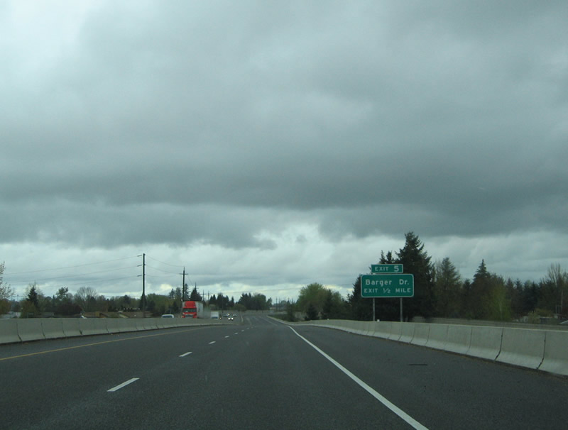
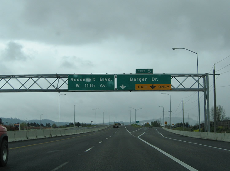
| OR 569/Belt Line Highway begins as a two lane expressway from OR 126 (West 11th Avenue) in west Eugene. The highway travels north 1.1 mile to the signalized intersection with Roosevelt Boulevard and from there 1.4 miles to Exit 5 (Barger Drive). Belt Line Highway passes over Royal Avenue with no access ahead of the diamond interchange with Barger Drive. 04/01/05 |
|
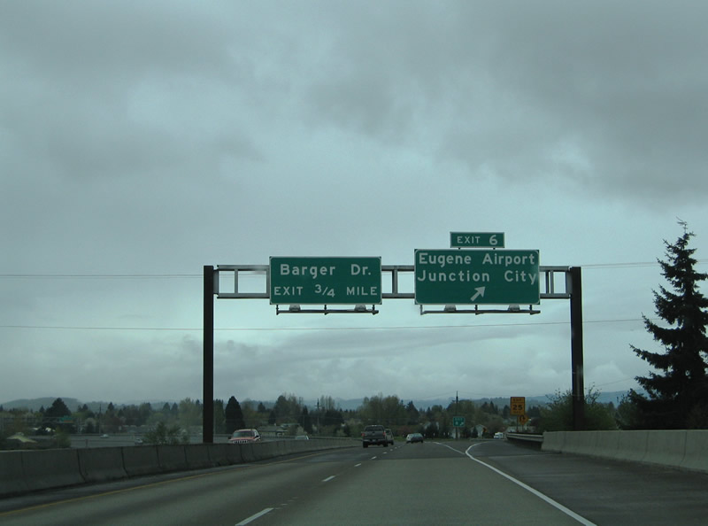
| Exit 5 departs Belt Line Highway eastbound for Barger Drive. Barger Drive travels 2.7 miles east from Green Hill Road to its end at OR 99 (Pacific Highway) in northwest Eugene. 04/01/05 |
|
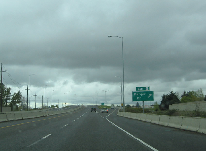
| An auxiliary lane joins the Belt Line Highway north from Exit 5 to OR 99 (Exit 6). The expressway upgrades to a full freeway north of Barger Drive. The Exit 6 folded diamond interchange joins the freeway with OR 99 (Pacific Highway) just north of the Eugene city limits. OR 99 parallels the Southern Pacific Railroad line southeast to 6th & 7th Avenues. 04/01/05 |
|
| Eastbound at the Exit 6 ramp departure to OR 99 (Pacific Highway). OR 99, the former routing of U.S. 99, links the city of Eugene with Eugene Airport (Mahlon Sweet Field) and Junction City to the northwest. 04/01/05 |
|
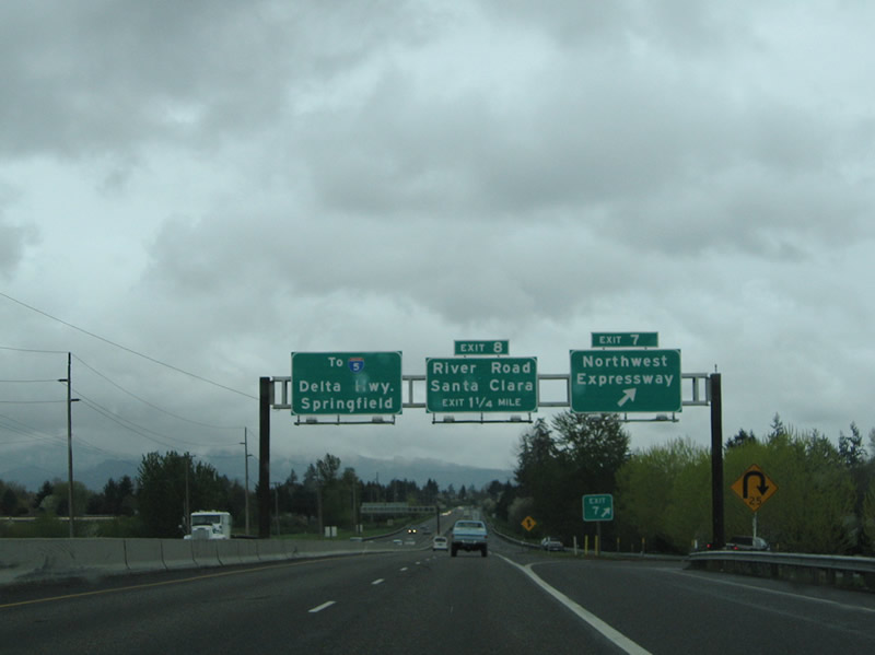
| Belt Line Highway prepares to pass over OR 99 and the Southern Pacific Railroad line ahead of the Exit 7 folded diamond interchange with the Northwest Expressway. A half diamond interchange brings traffic onto the freeway from Prairie Road. 04/01/05 |
|
| Exit 7 departs as a loop ramp to Northwest Expressway after the Amtrak under crossing on Belt Line Highway east. The Northwest Expressway branches north from River Road along residential areas of unincorporated Lane County. The controlled-access highway continues parallel to Amtrak 1.3 miles to its end at Irvington Drive and Prairie Road. 04/01/05 |
|
| The next interchange along OR 569/Belt Line Highway eastbound joins the four lane freeway with River Road in north Eugene. River Road stems north from Chambers Street and Roosevelt Boulevard parallel to the Willamette River. 04/01/05 |
|
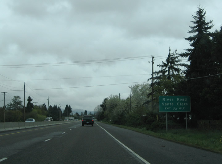
| Eastbound at the Exit 8 diamond interchange with River Road on Belt Line Highway. River Road continues north from the junction into the Eugene suburb of Santa Clara. River Road continues north from there on the 8.5 mile drive to Junction City. 04/01/05 |
|
| River Avenue travels east of the Silver Lane intersection with River Road to tie into Belt Line Highway at the next interchange. 04/01/05 |
|
| A short ramp departs Belt Line Highway eastbound for the adjacent River Avenue and the Division Avenue turnaround. Division Avenue forms a westbound side frontage road. River Avenue serves an industrial area along the eastbound side of Belt Line Highway. 04/01/05 |
|
| Belt Line Highway crosses the Willamette River and intersects the Delta Highway at a three-quarter cloverleaf interchange. The Delta Highway provides a two mile long freeway connection between OR 569/Belt Line Highway and Interstate 105 & OR 126. Interests to the Valley River Center mall, downtown Eugene, and the University of Oregon should use Delta Highway south. A loop ramp departs ahead for Delta Highway north, a two lane surface road traveling to Ayers Road. 04/01/05 |
|
| One half mile west of the Coburg Road diamond interchange on Belt Line Highway east at the Norkenzie Road over crossing. Coburg Road constitutes a north-south arterial between downtown Eugene and County Farm Road north of the city line. 04/01/05 |
|
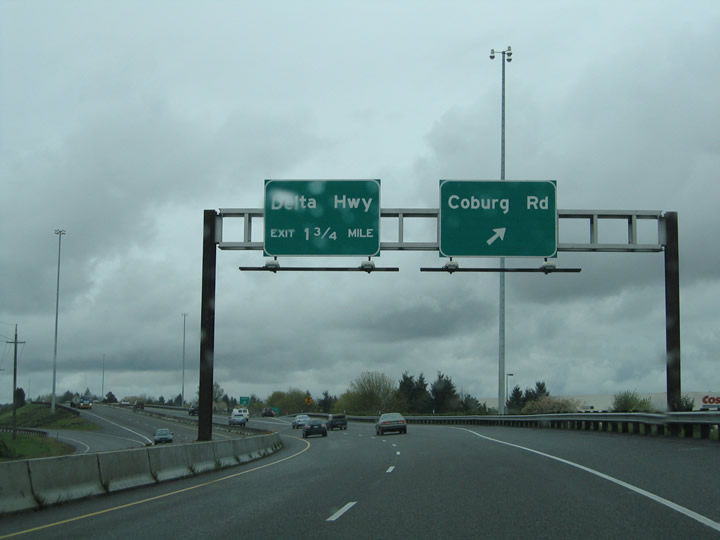
| An auxiliary guide sign touts the connections to downtown Eugene and Coburg for Coburg Road. The Eugene central business district lies 2.7 miles southwest across the Willamette River. Four miles separate OR 569/Belt Line Highway with the village of Coburg to the north. 04/01/05 |
|
| Belt Line Highway eastbound at the Coburg Road off-ramp. The pull-through panel references the connection to Interstate 5 and city of Springfield. Use Coburg Road south for Autzen Stadium, home of the University of Oregon Ducks college football. 04/01/05 |
|
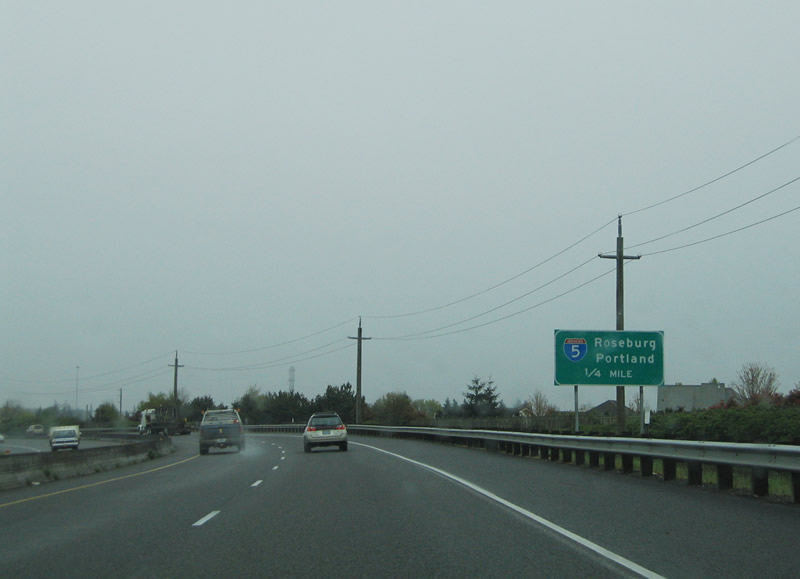
| The final interchange of Belt Line Highway eastbound is the cloverleaf interchange with Interstate 5. Interstate 5 straddles the Eugene and Springfield city line from Gateway Street south to Interstate 105 & OR 126. The freeway is the main north-south route in western Oregon, linking the cities of Ashland, Medford, Grants Pass, Roseburg, Eugene, Albany, Salem, and Portland. 04/01/05 |
|
| Leaving the Belt Line Highway eastbound first is the southbound off-ramp to Interstate 5 for Roseburg. Interstate 5 meets Interstate 105 & OR 126 one mile to the south. From there the freeway crosses the Willamette River into east Eugene and Goshen. 04/01/05 |
|
| End freeway marker posted between the loop ramps to/from Interstate 5 on Belt Line Highway eastbound. The freeway transitions into Belt Line Road, a two lane surface road linking the freeway with Game Farm Road. 04/01/05 |
|
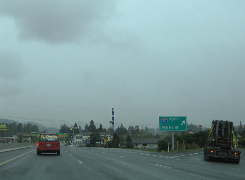
| Travelers headed north for Salem, Portland, or Seattle Washington loop onto Interstate 5 from Belt Line Highway. Interstate 5 reaches Coburg in 3.5 miles and Albany in 38 miles. 04/01/05 |
|
| Belt Line Highway transitions into Belt Line Road at the signalized intersection with Gateway Road east of Interstate 5. An END shield for OR 569 was added to this overhead sign bridge between 2005 and 2007. Gateway Road travels south to the Gateway Mall in Springfield and northwest to Coburg Road. Belt Line Road ends 0.4 miles ahead at Game Farm Road. 04/01/05, 11/06/07 |
|
| Belt Line Road transitions into the Belt Line Highway freeway west of the intersection with Gateway Road. Traffic funnels onto the freeway from the Gateway Mall area and Game Farm Road ahead of the cloverleaf interchange with Interstate 5. Reconstruction of the interchange is underway currently and will involve completion of a new flyover ramp from Interstate 5 north to Belt Line Highway west by November 2008. This eliminates the weaving traffic pattern at the southbound loop ramp. 04/01/05 |
|
| Westbound at the southbound loop ramp to Interstate 5. Interstate 5 sees two more interchanges to serve the Eugene area before meeting the 30th Avenue Expressway and OR 58 (Willamette Highway) near Goshen. Roseburg lies 70 miles to the south. 04/01/05 |
|
| The first mainline interchange of Belt Line Highway westbound is the exit with Coburg Road in north Eugene. Coburg Road derives its name from the connection to Coburg four miles to the north. 04/01/05 |
|
| Traffic interests to downtown Eugene or the University of Oregon can use Coburg Road, a north-south arterial, southward from Belt Line Highway. Coburg Road crosses the Willamette River into the Eugene central business district in 2.7 miles. 04/01/05 |
|
| Westbound at the Coburg Road ramp departure on Belt Line Highway west. Coburg Road meets Interstate 105 & OR 126 at Martin Luther King Jr. Boulevard near Autzen Stadium, home to the University of Oregon Ducks college football. 04/01/05 |
|
| After the on-ramp from Coburg Road, an OR 569 west reassurance shield is posted. This shield was added between 2005 and 2007. 11/06/07 |
|
| Sound barriers and a drainage canal parallel the Belt Line Highway between the Coburg Road diamond interchange and Gilham Road over crossing. 04/01/05 |
|
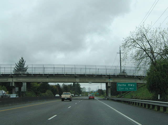
| Norkenzie Road passes over the Belt Line Highway one half mile east of the three-quarter cloverleaf interchange with Delta Highway. Delta Highway, completed in 1966, joins the Belt Line Highway with Interstate 105 & OR 126 northwest of downtown at the Willamette River. 04/01/05 |
|
| The Delta Highway off-ramp departs Belt Line Highway westbound. Delta Highway has interchanges with Goodpasture Island Road and Valley Center Drive for the Valley River Center mall on the two mile drive to Interstate 105 & OR 126. Delta Highway transitions into a two lane surface highway north of the interchange en route to Green Acres and Ayers Roads. 04/01/05 |
|
| A look at the Willamette River crossing on the Belt Line Highway westbound. Note the 1960s-era guard rails and design. 04/01/05 |
|
| Belt Line Highway departs the river crossing at the Division Avenue off-ramp. Division Avenue constitutes a westbound frontage road to River Road. The Division Avenue turnaround meets River Avenue on the south side of the freeway. River Avenue parallels the eastbound side of the freeway through an industrial zone. 04/01/05 |
|
| Next in line for westbound travelers is the Exit 8 diamond interchange with River Road. River Road comprises a north-south through route between west Eugene and the north suburb of Santa Clara. 04/01/05 |
|
| Drivers bound for River Road depart Belt Line Highway westbound at Exit 8. River Road heads 2.4 miles southeast to the junctions with the Northwest Expressway and Roosevelt Boulevard. Chambers Street continues the road south to OR 99 (7th & 6th Avenues). River Road continues 8.5 miles north of Belt Line Highway to Junction City. 04/01/05 |
|
| The Northwest Expressway ties into Belt Line Highway at the next westbound interchange (Exit 7B). The controlled-access highway parallels the Amtrak line alongside a residential area from River Road 4.5 miles north to Prairie Road and Irvington Drive. 04/01/05 |
|
| Belt Line Highway crosses over the Northwest Expressway and Amtrak line ahead of the Exit 7A half diamond interchange with Prairie Road. Prairie Road represents a 9.5 mile long companion to OR 99 (Pacific Highway) between Eugene and Junction City. The highway passes through industrial areas associated with the adjacent railroad. 04/01/05 |
|
| Belt Line Highway begins to turn southward ahead of the OR 99 and Southern Pacific Railroad line over crossing. OR 99 (Pacific Highway) parallels the railroad southeast into West Eugene. The former U.S. 99 provides the main route between Eugene and Corvalis, 34 miles to the northwest. 04/01/05 |
|
| Westbound at the Exit 6 folded diamond interchange with OR 99 (Pacific Highway) on Belt Line Highway. OR 99 travels 1.3 miles north to Airport Road and 8.6 miles to 1st Avenue within Junction City. Use Airport Road west to Eugene Airport. 04/01/05 |
|
| Drivers merging onto the Belt Line Highway westbound from OR 99 form the exit-only lane for Exit 5 (Barger Drive). The diamond interchange ahead is the last exit along the Belt Line Highway. 04/01/05 |
|
| A two lane off-ramp departs OR 569/Belt Line Highway south for Barger Drive. Barger Drive serves commercial and residential areas between the freeway east to OR 99 and residential areas west to Green Hill Road. 04/01/05 |
|
| The four lane freeway continues another mile south to the Royal Avenue under crossing and signalized intersection with Roosevelt Boulevard. 04/01/05 |
|
| Southbound at the Roosevelt Boulevard traffic light on Belt Line Highway. The West Eugene Parkway is planned to parallel Roosevelt Boulevard to the south. The urban arterial will see a full interchange with Belt Line Highway instead of a signalized intersection approximately three fifths of a mile south of Roosevelt Boulevard. Belt Line Highway otherwise downgrades into a two lane expressway to its end at OR 126 (West 11th Avenue). 04/01/05 |
|
| After OR 569/Belt Line Highway turns south at OR 99, it reverts to an expressway alignment. An END shield for OR 569 is posted at the intersection with OR 126 in western Eugene. 11/06/07 |
|
| Eastbound OR 126 approaches OR 569/Belt Line Highway. From here, OR 569 travels north to the interchange with OR 99, then turns east as a freeway to Interstate 5 at Exit 195. 11/06/07 |
|
| Southbound OR 99 approaches OR 569/Belt Line Highway. The ramp from southbound OR 99 onto eastbound OR 569 is a loop ramp, hence the right exit to OR 569 east. 11/06/07 |
Sources:
- Wiley, Mike. "Interstate 105 - www.ylekot.com/orehwys/i-105.html."
- Wiley, Mike. "Oregon Primary Highways - www.ylekot.com/orehwys/highways_primary.html."
- Elbert, Chris. "RE: OR 569/Belt Line Road," Email, 4/22/08.
04/01/05 by AARoads. 11/06/07 by Chris Elbert.
Connect with:
Interstate 5
Route 126 - Eugene and Springfield
Delta Highway - Eugene
Page Updated 04-21-2008.