|
| The eastern terminus of Alternate U.S. 14 is in Sturgis at its interchange with Interstate 90, U.S. 14, South Dakota 34 and South Dakota 79. 09/03/04 |
|
| Interstate 90 travels southeast to Rapid City and northwest toward Spearfish and Wyoming. The freeway skirts the eastern and northern edge of the Black Hills, and it does not penetrate the national forest west of Sturgis. 09/03/04 |
|
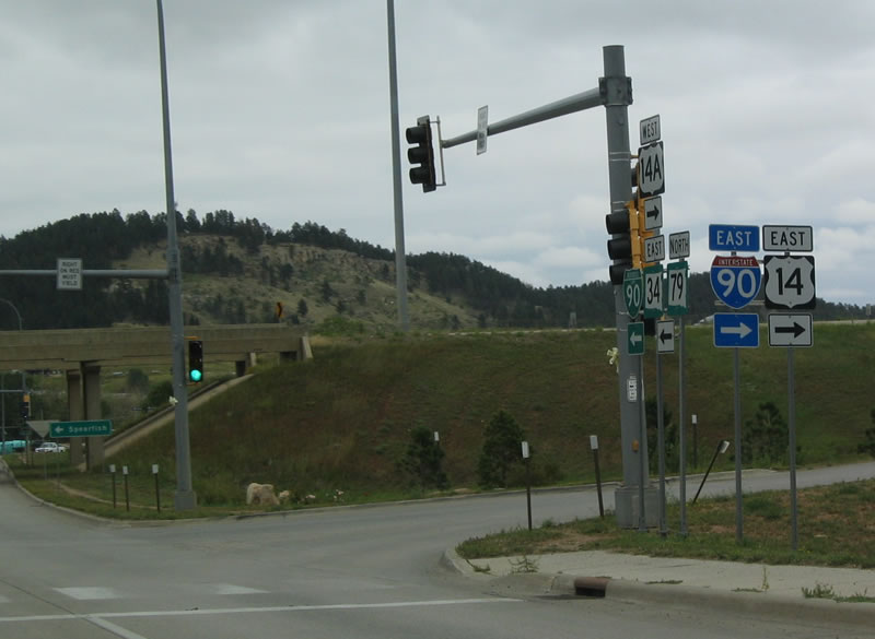
| U.S. 14A ends in northwest Sturgis as the eastbound on-ramp to I-90 & U.S. 14 departs for Rapid City. SD-79 runs south along the freeway as well. 09/03/04 |
|
| After passing under the freeway, U.S. 14A transitions into Business Loop I-90, South Dakota 34 east and South Dakota 79 north. These three routes continue east into Downtown Sturgis while U.S. 14 remains on the freeway around Sturgis. 09/03/04 |
|
| Alternate U.S. 14 begins at a diamond interchange (Exit 30) with Interstate 90 and U.S. 14 in northwest Sturgis. U.S. 14A travels west to Deadwood, south to Cheyenne Crossing via Central City and Lead, and north to Spearfish via Spearfish Canyon. 09/03/04 |
|
| This is the first reassurance shield for westbound U.S. 14A. Dark storm clouds hung over the Black Hills, portending rain showers for the evening. 09/03/04 |
|
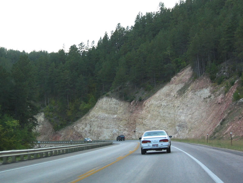
| U.S. 14A travels through the Black Hills National Forest, with rock cuts along the way. 09/03/04 |
|
| At certain intervals, U.S. 14A widens to accommodate passing lanes. Here, U.S. 14A is four lanes wide. 09/03/04 |
|
| As U.S. 14A approaches Deadwood, the highway also approaches U.S. 85. The rock cut on the hill is for northbound U.S. 85 toward Whitewood. 09/03/04 |
|
| Alternate U.S. 14 approaches U.S. 85 northeast of Deadwood. The two routes merge together to pass through Deadwood, then split briefly between Deadwood and Lead. 09/03/04 |
|
| Westbound U.S. 14A enters the city of Deadwood. Founded in 1876, Deadwood was established during the Black Hills gold rush. During that era, Deadwood was well known for its notorious personalities, including Wild Bill Hickok and Calamity Jane. Gambling was popular in those days but was outlawed in 1947. It is still popular today, having been legalized in 1989. Located at an elevation of 4,533 feet above sea level, Deadwood was home to 1,270 people as of the 2010 Census. 09/03/04 |
|
| U.S. 14A and U.S. 85 combine at this intersection north of Deadwood. The two routes bypass Downtown Deadwood but provide a business route into the city center. To the north, U.S. 85 travels toward Whitewood and Spearfish. 09/03/04 |
|
| This is the first reassurance shield assembly for westbound U.S. 14A and southbound U.S. 85. Note the Can-Am Highway shield posted beneath U.S. 85. The highway carries two lanes of traffic as it descends into the valley containing Downtown Deadwood. 09/03/04 |
|
| This shield assembly features older specifications for U.S. 14A, with three digits squeezed into a two-digit shield. Shortly after this shield assembly, U.S. 14A and U.S. 85 skirt Downtown, while Main Street travels into the city center. 09/03/04 |
|
| Portions of the U.S. 14A/U.S. 85 bypass travel on a viaduct to pass over a creek. Only selected city streets connect between U.S. 14A/U.S. 85 and Downtown. 09/03/04 |
|
| Between Deadwood and Lead, U.S. 14A and U.S. 85 split briefly. U.S. 85 follows the most direct route to Lead via Pluma, while U.S. 14A connects between the two cities via Central City. 09/03/04 |
|
| Deadwood sits in a tight valley, and this photo shows the narrow Downtown area of Deadwood as seen from the Mt. Moriah Cemetery. 09/03/04 |
Page Updated 11-06-2005.

 East
East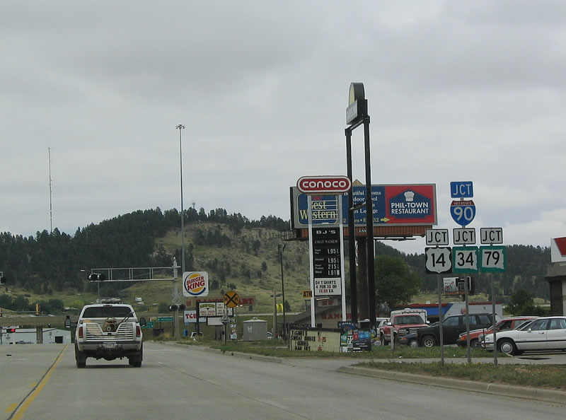


 South
South


