|
| SR 211 (New Market Road) leads 5.63 miles east from SR 42 (Main Street) in Timberville to New Market where it connects with U.S. 211 and Interstate 81. 06/06/04 |
|
| U.S. 211 commences along Old Cross Road eastbound from I-81 at Exit 264 ahead of Cadet Road (SR 1003) in the town of New Market. 12/30/08 |
|
| U.S. 11/211 overlap 0.27 miles north along Congress Street from Old Cross Road (SR 1002) in the New Market business district. U.S. 11 south leads 1.16 miles into Rockingham County. 12/30/08 |
|
| U.S. 11 is signed as an alternate route for I-81 north to SR 730 (Caverns Road) for Exit 269. SR 1002 continues Old Cross Road (former U.S. 211) directly to U.S. 211 (Lee Highway) leading east out of New Market. 12/30/08 |
|
| U.S. 11/211 combine for three blocks along Congress Street in New Market. 12/30/08 |
|
| U.S. 211 turns east along Lee Highway from U.S. 11 (Congress Street) to traverse Massanutten Mountain en route to Luray. 12/30/08 |
|
| U.S. 11 continues north to Winchester via the towns of Mt. Jackson and Edinburg, while U.S. 211 travels east to Warrenton. 12/30/08 |
|
| U.S. 211 (Lee Highway) converges with Old Cross Road (SR 1002) east by this distance sign posted 13 miles from Luray. The 132 miles to Washington, DC references the former maximum extent of U.S. 211. 06/06/04 |
|
| U.S. 211 (Lee Highway) expands into a four lane divided highway from SR 1002 (Old Cross Road) east to SR 620 (Smith Creek Road). 12/30/08 |
|
| Advancing toward Massanhuetten Mountain, U.S. 211 (Lee Highway) lowers from 1,020 feet in elevation to 944 feet across Smith Creek. 12/30/08 |
|
| SR 620 (Smith Creek Road) meanders along the western foothills of Massanhuetten Mountain north to Shavertown and south to SR 735 (White Mill Road) leading back to New Market. 12/30/08 |
|
| U.S. 211 climbs over 800 feet in elevation from Smith Creek to New Market Gap and the Page County line. 12/30/08 |
|
| U.S. 211 (Lee Highway) descends from Massanutten Mountain into Page Valley, combining with U.S. 340 east ahead of Salem and the South Fork of the Shenandoah River. U.S. 340 heads south to Shenandoah , Waynesboro and U.S. 11 west of Stuarts Draft. 06/06/04 |
|
| U.S. 211 east and U.S. 340 north overlap for 7.60 miles along Lee Highway into Luray. 06/06/04 |
|
| U.S. 211 Business branches east from U.S. 211/340 (Lee Highway) along W Main Street to Downtown Luray. U.S. 340 Business follows Broad Street north from Virginia Avenue across the town. 06/06/04 |
|
| U.S. 211 Business follows Main Street 4.10 miles east across Luray. U.S. 211 bypasses Downtown along an expressway to the north. Seat of Page County, the town of Luray spreads across elevations that range from 800 to 1,000 feet above sea level. 06/06/04 |
|
| Cave Hill Road connects U.S. 211/340 with Luray Caverns. One of several in the Blue Ridge Mountains along with Shenandoah Caverns and Endless Caverns, Luray Caverns is one of the most spectacular caverns in the region. It is perhaps best known for a pipe organ that is built into the stalactites and stalagmites in one of the larger underground chambers. 06/06/04 |
|
| U.S. 211 and U.S. 340 divide at a diamond interchange with U.S. 340 Business (Broad Street) north of Downtown Luray. 06/06/04 |
|
| U.S. 340 continues through northern reaches of Page Valley to Front Royal. U.S. 211 east crosses the Blue Ridge Mountains at Skyline Drive and Thornton Gap. 06/06/04 |
|
| U.S. 340 Business runs 12.95 miles south from Luray to Longs Store and west from Stnley to Alma. 06/06/04 |
|
| Leaving Shenandoah National Park, U.S. 211 advances east to the community of Sperryville. 31 miles of U.S. 211 remain to Warrenton. 06/06/04 |
|
| SR 1001 (Main Street) provides a cutoff in Sperryville from U.S. 211 (Lee Highway) east across the Thornton River to U.S. 522 (Sperryville Pike). Trucks are restricted from the narrow 0.20 mile long route. 06/06/04 |
|
| Bypassing Sperryville to the north, U.S. 211 (Lee Highway) converges with U.S. 522 (Sperryville Pike). U.S. 522 is a regional highway connecting central Pennsylvania with central Virginia. U.S 522 runs southeast to Culpeper. SR 231 (F.T. Valley Road) branches southwest nearby to Madison. 06/06/04 |
|
| U.S. 211/522 overlap 5.71 miles east from Sperryville to Massies Corner. U.S. 211 Business comprises a 1.50 mile long loop north from Lee Highway into the town of Washington. 06/06/04 |
|
| U.S. 211 Business loops 1.50 miles into Washington along Main Street. Founded in 1749 and incorporated in 1894, the town is known as the "first" Washington. 06/06/04 |
|
| When U.S. 211 Business was established in 1971, it was dually designated as U.S. 522 Business. 06/06/04 |
|
| U.S. 522 splits with U.S. 211 (Lee Highway) east of Rose Hill for Zachary Taylor Avenue north 2.82 miles to Flint Hill. 06/06/04 |
|
| U.S. 522 (Zachary Taylor Highway) heads northwest toward Front Royal and Winchester beyond Chester Gap over the Blue Ridge Mountains. U.S. 211 (Lee Highway) arcs southeast by Jefferson Mountain toward Warrenton. 06/06/04 |
|
| U.S. 522 (Zachary Taylor Highway) follows a rural two lane highway north between Little Mulky and Hickerson Mountains while U.S. 211 remains along a four lane expressway east to Ben Venue and Amissville. 06/06/04 |
|
| U.S. 211 proceeds east along the Robert E. Lee Highway 20 miles to Warrenton. The control city remains Washington, D.C., which was the original eastern terminus of U.S. 211. 06/06/04 |
|
| Positioned at the northeastern gateway to the Blue Ridge Mountains, the town of Warrenton is the seat of Fauquier County. Home to nearly 10,000, Warrenton was incorporated in 1810 and close to the site of several Civil War battles. 06/06/04 |
|
| U.S. 211 (Frost Avenue) converges with U.S. 17-29 Business (W Shirley Avenue and U.S. 211 Business (Waterloo Street) northwest of Downtown Warrenton. 06/06/04 |
|
| U.S. 17-29 Business follow Shirley Avenue south 2.54 miles from U.S. 211 (Frost Avenue) to a dumbbell interchange with U.S. 15/17/29 along the Eastern Bypass. 06/06/04 |
|
| Beyond Warrenton, U.S. 17 connects with I-66 west to Winchester and U.S. 29 north with I-66 east to Washington, D.C. 06/06/04 |
|
| U.S. 211 combines with U.S. 17-29 Business along Broadview Avenue 0.86 miles to Lee Highway and Winchester Street. 06/06/04 |
|
| U.S. 17 Business (Broadview Avenue) returns to U.S. 17 (James Madison Highway) 0.82 miles north from U.S. 211/29 Business (Lee Highway). 06/06/04 |
|
| U.S. 29 Business continues with U.S. 211 east along Lee Highway 0.55 miles to U.S. 211 Business (Winchester Street) and Blackwell Road (SR 672). 06/06/04 |
|
| U.S. 211 concludes eastbound along Lee Highway where U.S. 15 Business combines with U.S. 29 Business from Winchester Street and Downtown Warrenton. 06/06/04 |
|
| U.S. 15-211 Business (Winchester Street) overlap 1.04 miles south to Main and Waterloo Streets in the Warrenton business district. U.S. 15-29 Business join 0.86 miles east along Lee Highway to U.S. 15/29 (Eastern Bypass) north. 06/06/04 |
|
| U.S. 15-29 Business link the east end of U.S. 211 with U.S. 15-29 north to Leesburg and Washington, D.C., and U.S. 15-17-29 south to Culpeper and Fredericksburg. 06/06/04 |
Page Updated 04-14-2021.


 East
East


 North
North 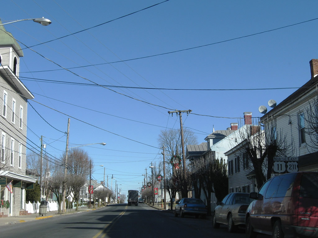


 North
North


 North
North


 North
North


