|
| One of the older sections of the freeway, SR 288 between I-95 and SR 76 (Powhite Parkway) opened to traffic in 1990. 06/01/05 |
|
| The first exit on northbound SR 288 is with U.S. 1/301 (Jefferson Davis Highway). U.S. 1/301 south of Richmond is named in honor of the President of the Confederate States of America, Jefferson Davis, during the Civil War Era of United States History (1861-1865). His name carries controversy, since he is linked to an era of great difficulty in American history. 06/01/05 |
|
| U.S. 1/301 (Jefferson Davis Highway) runs north from SR 288 to Kingsland, Bensley and Downtown Richmond. 06/01/05 |
|
| Paralleling I-95 to the west, U.S. 1/301 travels south from SR 288 toward Colonial Heights and Petersburg while skirting Chester to the east. Once in Petersburg, U.S. 1 branches southwest from U.S. 301 along the I-85 corridor. 06/01/05 |
|
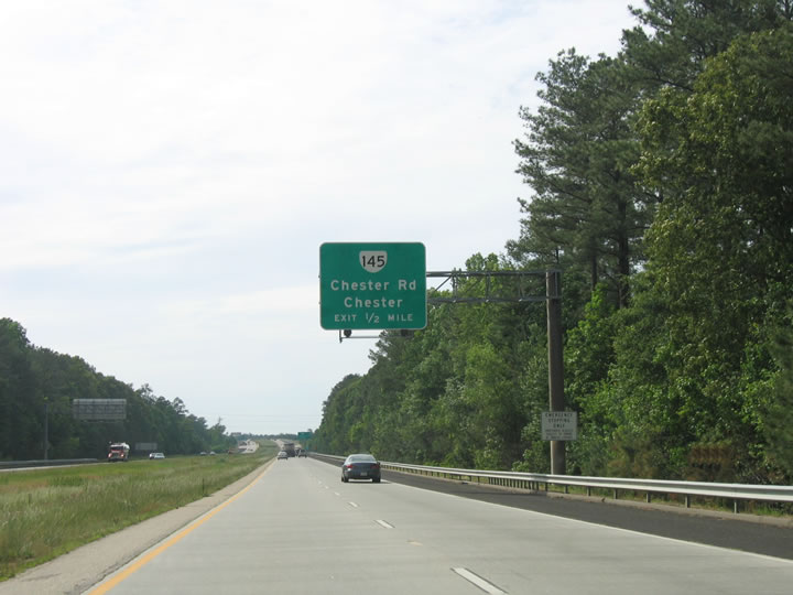
| This interchange sequence sign posted one mile ahead of SR 145 (Chester Road) was replaced with a ground level sign after 2016. The concrete roadway was resurfaced with asphalt in 2016. 08/08/04 |
|
| SR 288 weaves through suburban areas west seven miles to Chesterfield and north 24 miles to Midlothian. 06/01/05 |
|
| Connecting SR 10 in Chesterfield with U.S. 1/301 between Kingsland and Bensley, SR 145 follows Chester Road north from SR 144 and Centralia Road to the west. 06/01/05 |
|
| Entering the diamond interchange with SR 145 (Chester Road) on SR 288 northbound. SR 144 extends Chester Road south 1.77 miles to SR 10 at Chester. 08/08/04 |
|
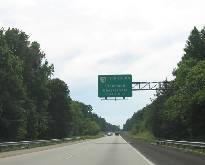
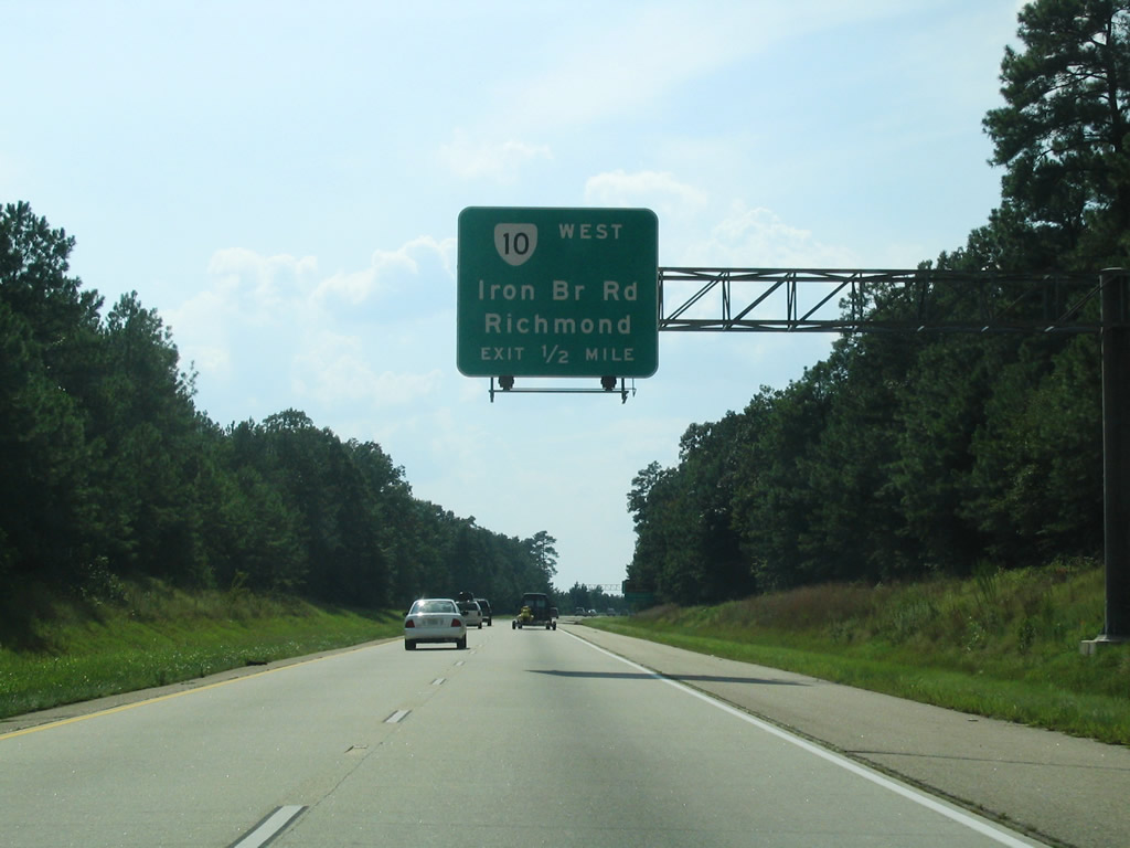
| SR 288 advances two miles west to SR 10 (Iron Bridge Road) at Chesterfield. 06/01/05 |
|
| The cloverleaf interchange with SR 10 (Iron Bridge Road) falls between mileposts 6 and 6.88 on SR 288 northbound. 06/01/05 |
|
| Heading north from Chesterfield to South Richmond, SR 10 overall travels northwest to southeast, generally matching the course of the James River. The state route originates in Suffolk and ends at SR 161 in Richmond. 08/08/04 |
|
| The westbound exit ramp for SR 10 (Iron Bridge Road) departs SR 288 to Chesterfield County Airport (FCI) and Richmond. 06/01/05 |
|
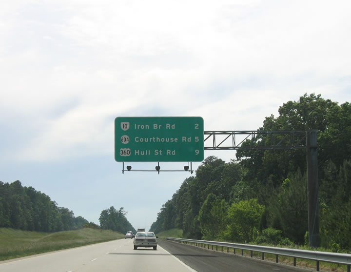
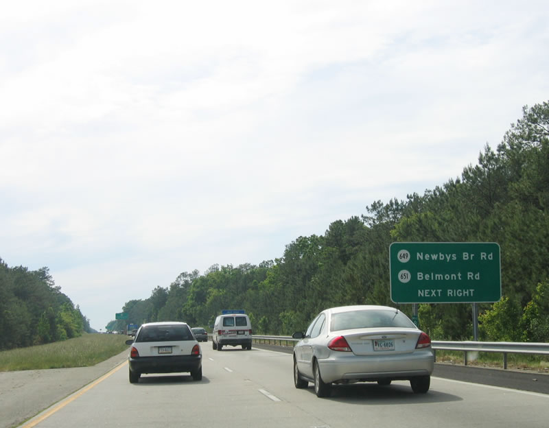
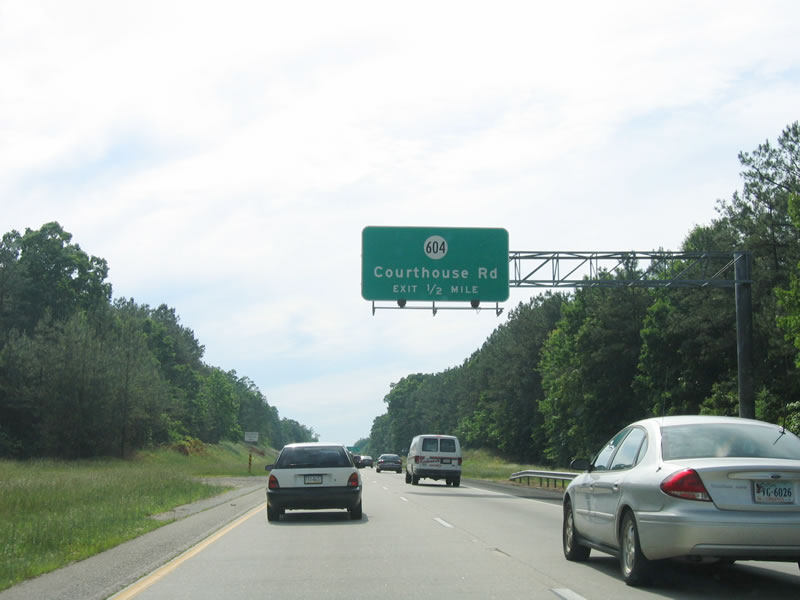
| Parallel SR 604 (Courthouse Road) converges with SR 288 at the succeeding interchange. 06/01/05 |
|
| SR 604 east connects SR 288 with Pocahontas State Park. Located along Swift Creek, the park features hiking along Beaver Lake. 06/01/05 |
|
| SR 604 (Courthouse Road) is an arterial route north to Genito Road, which leads the route west to U.S. 360 (Hull Street Road). SR 604 crosses SR 288 again en route to Swift Creek Reservoir. 08/08/04 |
|
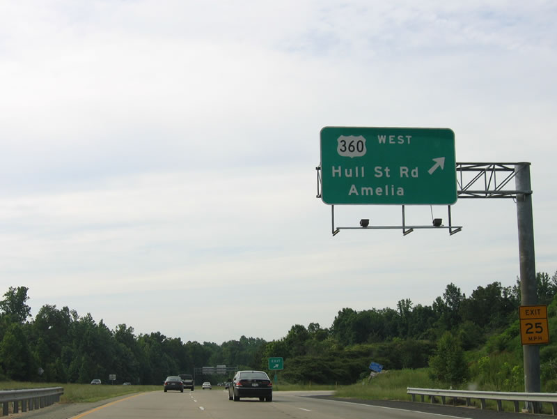
| U.S. 360 (Hull Street Road) converges with SR 288 at the ensuing exit. 06/01/05 |
|
| U.S. 360 is Hull Street Road extends Hull Street southwest out of the urban areas of Chesterfield County to rural areas west of Swift Creek Reservoir. 06/01/05 |
|
| U.S. 360 runs diagonally across the state of Virginia, originating in Danville to the southwest and ending in Reedville along Chesapeake Bay. The highway along Hull Street Road constitutes a commercial arterial into Richmond. 06/01/05 |
|
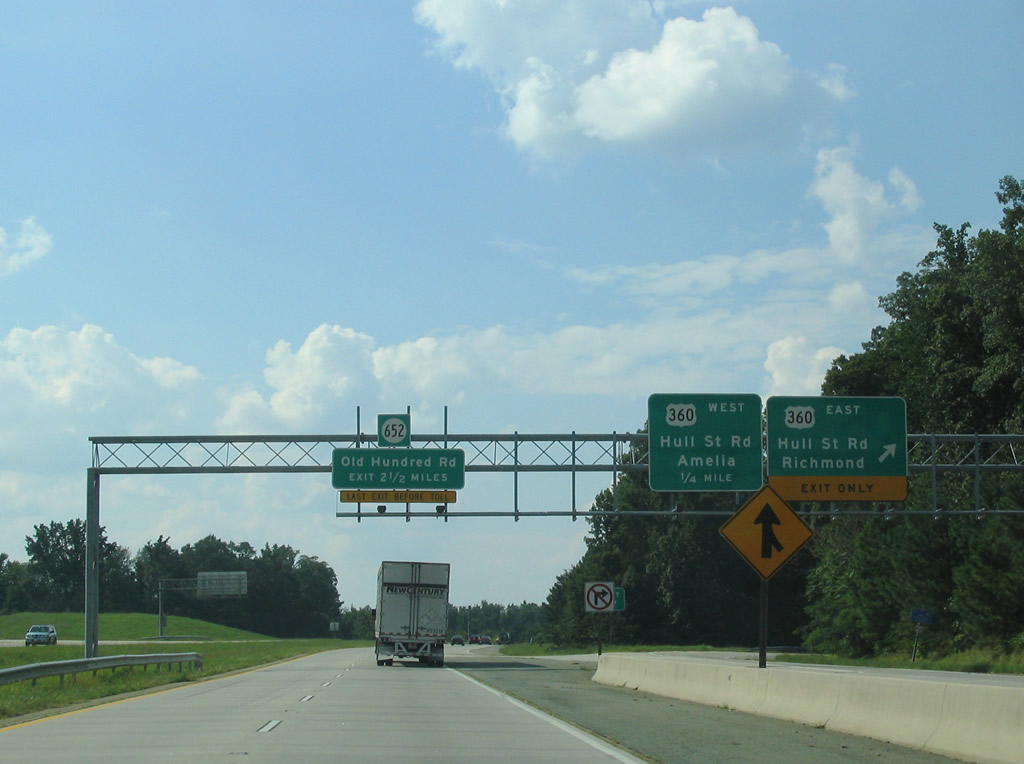
| A wye interchange with Commonweatlh Centre Parkway forms a c/d roadway along SR 288 northbound to the exit for U.S. 360 (Hull Street Road) east. 06/01/05 |
|
| The SR 288 freeway temporarily ended north of U.S. 360 at Lucks Lane until November 19, 2004. 08/08/04 |
|
| A loop ramp joins northbound SR 288 with U.S. 360 west to Amelia. 06/01/05 |
|
| Advancing north toward Midlothian, SR 288 meets SR 76 (Powhite Parkway) at a cloverleaf interchange. 08/08/04 |
|
| Powhite Parkway is a toll road leading northeast 13.04 miles from SR 652 (Charter Colony Parkway) to I-195 (Beltline Expressway) and SR 195 (Downtown Expressway) in Richmond. 06/01/05 |
|
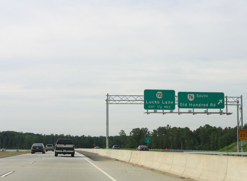
| A c/d roadway separates from SR 288 north for SR 76 (Powhite Parkway) and the succeeding diamond interchange with SR 720 (Lucks Lane). 06/01/05 |
|
| SR 76 (Powhite Parkway) travels northeast around Midlothan to SR 150 (Chippenham Parkway) on the Richmond city line. The toll road links with I-195 north to I-64/95 and SR 195 east to the State Capitol. 06/01/05 |
|
| SR 76 (Powhite Parkway) spurs 1.15 miles west to SR 652 (Old Hundred Road) and the Roseland community. 06/01/05 |
|
| SR 288 north at SR 76 (Powhite Parkway) prior to completion of the 3.7 mile link from Lucks Lane to U.S. 60. 08/08/04 |
|
| Navigating through an S-curve, SR 288 meets Lucks Lane (SR 720) at Midlothian. 06/01/05 |
|
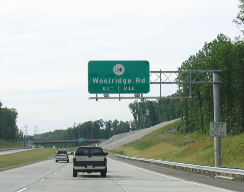
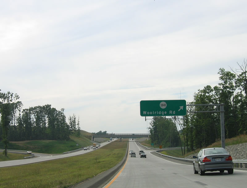
| A diamond interchange joins SR 288 with SR 688 (Woolridge Road) at mile marker 19. 06/01/05 |
|
| Woolridge Road is an arterial leading east from SR 288 to John Tyler Community College - Midlothian Campus and U.S. 60 at Old Buckingham Road. 06/01/05 |
|
| Guide signs for Woolridge Road originally referenced the arterial as SR 3840. 06/01/05 |
|
| U.S. 60 (Midlothian Turnpike) and SR 288 meet at what was a rural cloverleaf interchange. Commercial development got underway with Westchester Commons in the northwest quadrant of the exchange in 2008. 06/01/05 |
|
| A set of power lines span SR 288 north beyond Woolridge Road. 06/01/05 |
|
| U.S. 60 travels across the width of Virginia from near White Sulfur Springs, West Virginia to Virginia Beach. Regionally, U.S. 60 leads west to Powhatan and Cumberland from Richmond. 06/01/05 |
|
| C/d roadways separate from the SR 288 mainline for the ramps with U.S. 60 (Midlothian Turnpike). 06/01/05 |
|
| Like U.S. 360 (Hull Street Road) to the south, U.S. 60 east along Midlothian Turnpike constitutes a heavily developed commercial arterial east into Richmond. 06/01/05 |
|
| U.S. 60 (Midlothian Turnpike) transitions into a rural four lane highway west en route to Powhatan and the south end of U.S. 522. 12/21/08 |
|
| Continuing north, SR 288 runs alongside Westchester Commons, where right in right out (RIRO) style ramps were built along the southbound roadway. 12/21/08 |
|
| SR 288 parallels Michauk Creek northward and enters Powhatan County. 12/21/08 |
|
| The next two exits along SR 288 northbound are SR 711 (Huguenot Trail) and SR 6 (Patterson Road). 12/21/08 |
|
| SR 711 (Huguenot Trail) becomes Robious Road east across the Chesterfield County line en route to U.S. 60 (Midlothian Turnpike) in Midlothian. Completed in June 2019, a $19.6 million project expanded SR 711 from two to four lanes between SR 288 and the county line.1 06/01/05 |
|
| West from the diamond interchange with SR 288, SR 711 (Huguenot Trail) follows the James River to U.S. 522 at Jefferson. 12/21/08 |
|
| SR 288 passes by agricultural areas north from SR 711 to the James River. 12/21/08 |
|
| The World War II Veterans Memorial Bridge takes SR 288 across the James River into Goochland County at mile marker 25. 12/21/08 |
|
| The 6.7 mile section of SR 288 north from U.S. 60 to SR 6 beyond the James River opened to traffic on August 27, 2004.2 12/21/08 |
|
| SR 6 (Patterson Avenue) follows the James River east from Scottsville to Richmond. The state route begins at U.S. 250 in Afton, southeast of Waynesboro and Skyline Drive. 12/21/08 |
|
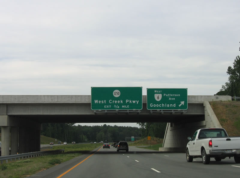
| The cloverleaf interchange with SR 6 (Patterson Street) lies just east of West Creek Parkway and west of Tuckahoe. 12/21/08 |
|
| Two lanes depart from SR 288 north for SR 6 (Patterson Avenue) east toward Richmond. 06/01/05 |
|
| SR 6 (Patterson Avenue) continues west to the county seat of Goochland, where it combines with U.S. 522. 06/01/05 |
|
| The entrance ramp from SR 6 west forms an auxiliary lane along SR 288 north to SR 1250 (West Creek Parkway). 06/01/05 |
|
| Meeting SR 288 at a parclo interchange, West Creek Parkway (SR 1250) loops 2.97 miles north from SR 6 (Patterson Avenue). 06/01/05 |
|
| SR 288 continues north across Broad Branch to a cloverleaf interchange with SR 740 (Tuckahoe Creek Parkway). 06/01/05 |
|
| SR 740 (Tuckahoe Creek Parkway) spurs southeast to a dead end near Tuckahoe Creek. 06/01/05 |
|
| West from SR 288, Tuckahoe Creek Parkway passes by the West Creek Commons commercial complex en route to the Kinloch golf course development. 06/01/05 |
|
| SR 288 converges with Tuckahoe Creek on the ensuing stretch north to U.S. 250 (Broad Street). 06/01/05 |
|
| U.S. 250 begins in Richmond and parallels I-64 west to nearby Short Pump, Charlottesville and Staunton. 06/01/05 |
|
| The folded diamond interchange with U.S. 250 (Broad Street) sits between Tuckahoe and Little Tuckahoe Creeks. Commercial development accompanies Broad Street east from SR 288 all the way to Richmond. 06/01/05 |
|
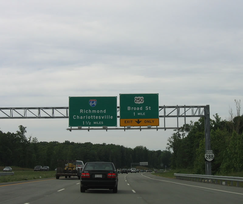
| SR 288 concludes at a directional T interchange with Interstate 64 just beyond U.S. 250 (Broad Street). 06/01/05 |
|
| A third lane opens from the U.S. 250 entrance ramp for Interstate 64 east to Richmond. The north end of SR 288 was originally proposed to tie directly into I-295 at its exchange with I-64. 12/16/16 |
|
| A two lane flyover joins SR 288 north with Interstate 64 west to Charlottesville, the University of Virginia and Staunton. I-295 commences southbound from I-64 at Short Pump just to the east. 12/16/16 |
Page Updated 07-01-2020.