|
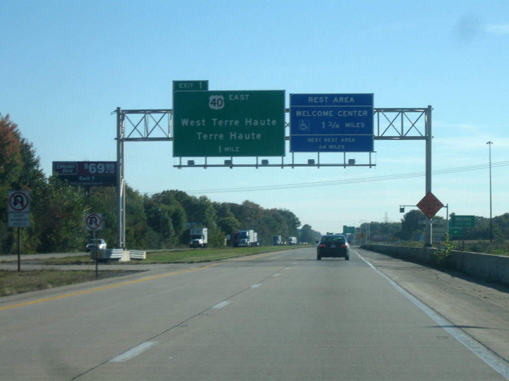
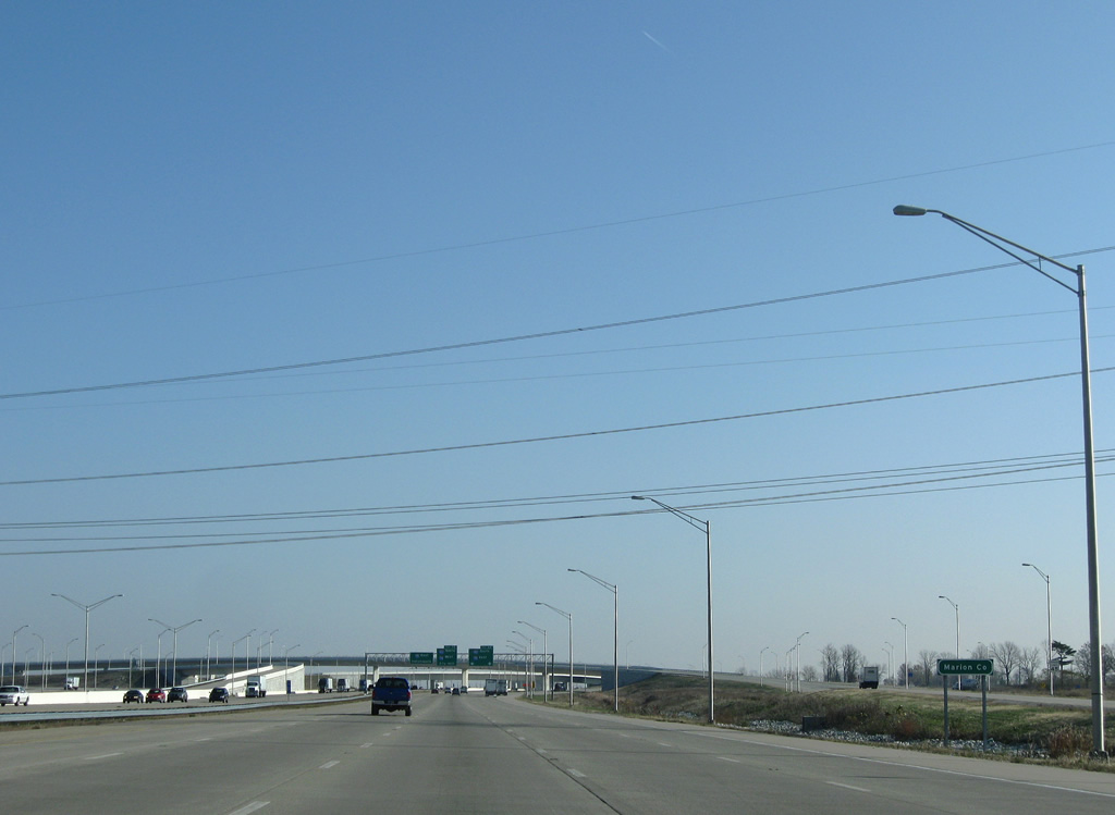
| I-70/U.S. 40 enter Indiana one mile from Exit 1 with National Avenue (former U.S. 40 east). The Indiana welcome center is 1 3/4 miles away just past Exit 1; the next rest area is located near Plainfield just outside of Indianapolis. A weigh station serves eastbound truckers entering from Illinois into Indiana just beyond the state line.
The blank space at the upper part of the sign marks where the U.S. 40 shield was. 03/18/12 |
|
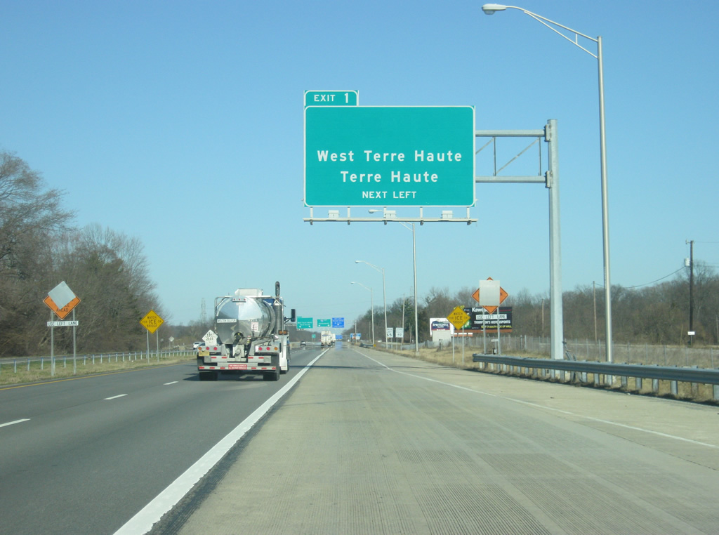
| Until January 2011, U.S. 40 broke off at the directional Y interchange east toward the communities of West Terre Haute and Terre Haute. U.S. 40 now follows Interstate 70 further to the east to Exit 11 where it joins SR 46 north to its present-day alignment east of Terre Haute. 10/10/09 |
|
| The entrance ramp from the weigh station forms an auxiliary lane east to the Indiana welcome center. Exit 1 is the first of four to serve the greater Terre Haute area. Terre Haute, the county seat of Vigo County, is the largest city in the bi-state Wabash Valley region. 03/18/12 |
|
| National Avenue (former U.S. 40) breaks off at a directional Y interchange at Exit 1 toward the town of West Terre Haute (five miles away) and downtown Terre Haute (seven miles away). The Indiana Welcome Center is now a half mile away. National Avenue follows the route of the historic National Road toward the northeast as a four lane highway toward West Terre Haute and the junction with U.S. 150, which continues east into Terre Haute. 03/18/12, 10/10/09 |
|
| The far right lane exits to the Clear Creek Welcome Center that serves eastbound I-70/U.S. 40 travelers into the Hoosier State. 03/18/12 |
|
| Reassurance shields for Interstate 70 and U.S. 40 east reflect the new multiplex between the two highways to the east of the Clear Creek Welcome Center. The rerouting of U.S. 40 has it bypass the city of Terre Haute along Interstate 70 to Exit 11 and represents the first major rerouting of U.S. 40 off the path of the historic National Road since U.S. 40 was moved to Interstate 465 in Indianapolis. 03/18/12 |
|
| The Indiana welcome sign for I-70/U.S. 40 stands 2.1 miles east of the Illinois state line. 03/18/12 |
|
| Officially, I-70/U.S. 40 east is four miles away from downtown Terre Haute. Indianapolis, Interstate 70's eastbound control city since St. Louis, is 75 miles away. 03/18/12 |
|
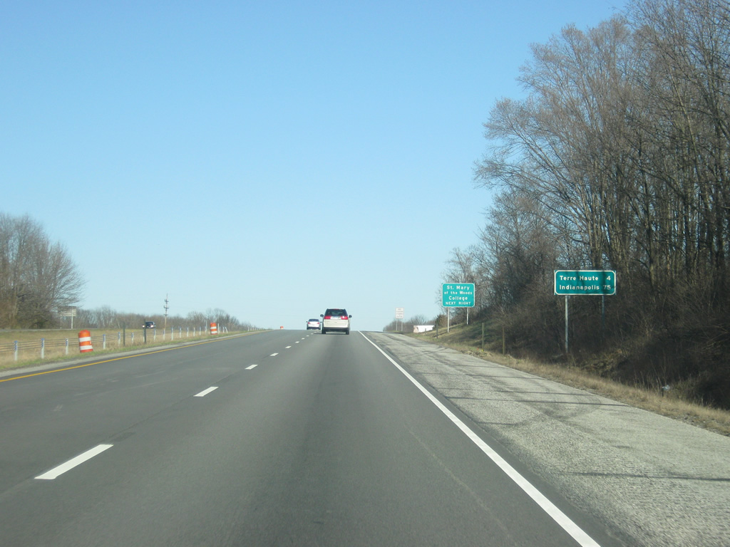
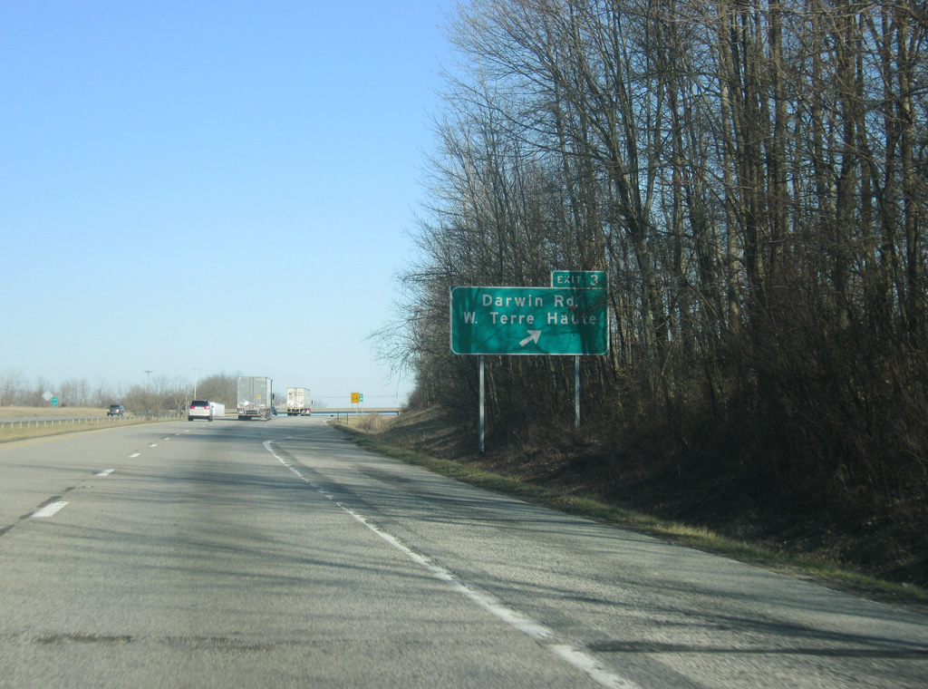
| St. Mary of the Woods College, founded by Saint Mother Theodore Guerin, the first Roman Catholic saint from Indiana, is located off of Exit 3 via Darwin Road, National Avenue (former U.S. 40) and U.S. 150 north of West Terre Haute. 03/18/12 |
|
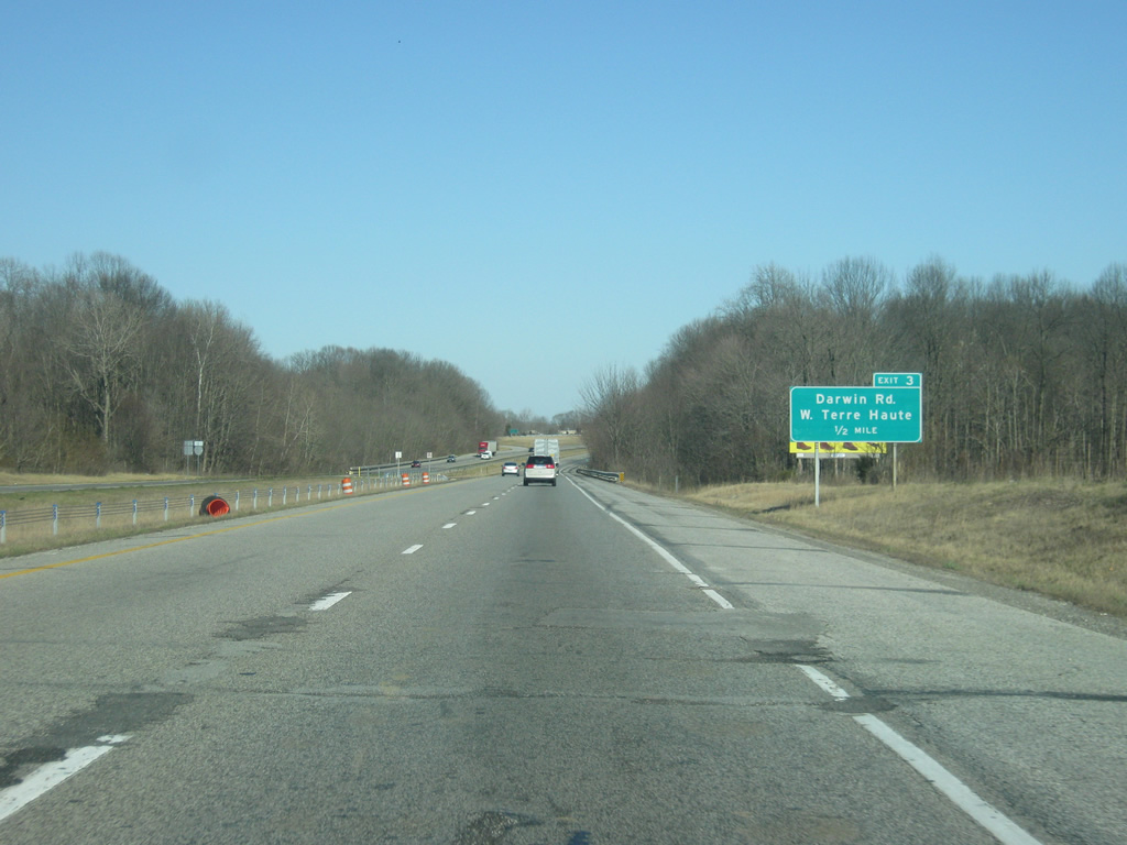
| Darwin Road crosses paths with I-70/U.S. 40 east at a parclo interchange one mile west of Sugar Creek. Darwin Road stems south from former U.S. 40 (National Avenue) near West Terre Haute to Larimer Hill and Exit 3. 03/18/12 |
|
| Exit 3 turns off of I-70/U.S. 40 east for Darwin Road, which continues southwest to Iron Bridge Road in a rural area of Clark County, Illinois. 03/18/12 |
|
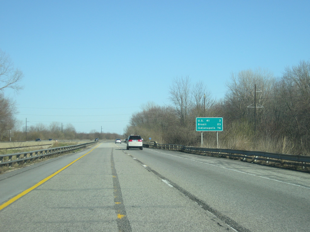
| East of Exit 3 (Darwin Road), the interchange with U.S. 41 (and U.S. 150) is three miles away. The Clay County seat of Brazil is 23 miles further to the east with Indianapolis at 76 miles. 03/18/12 |
|
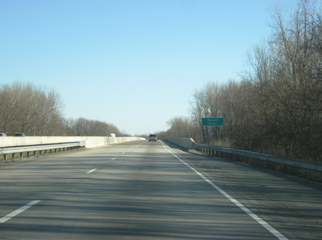
| Crossing the Wabash River and entering the city of Terre Haute along I-70/U.S. 40 east. 03/18/12 |
|
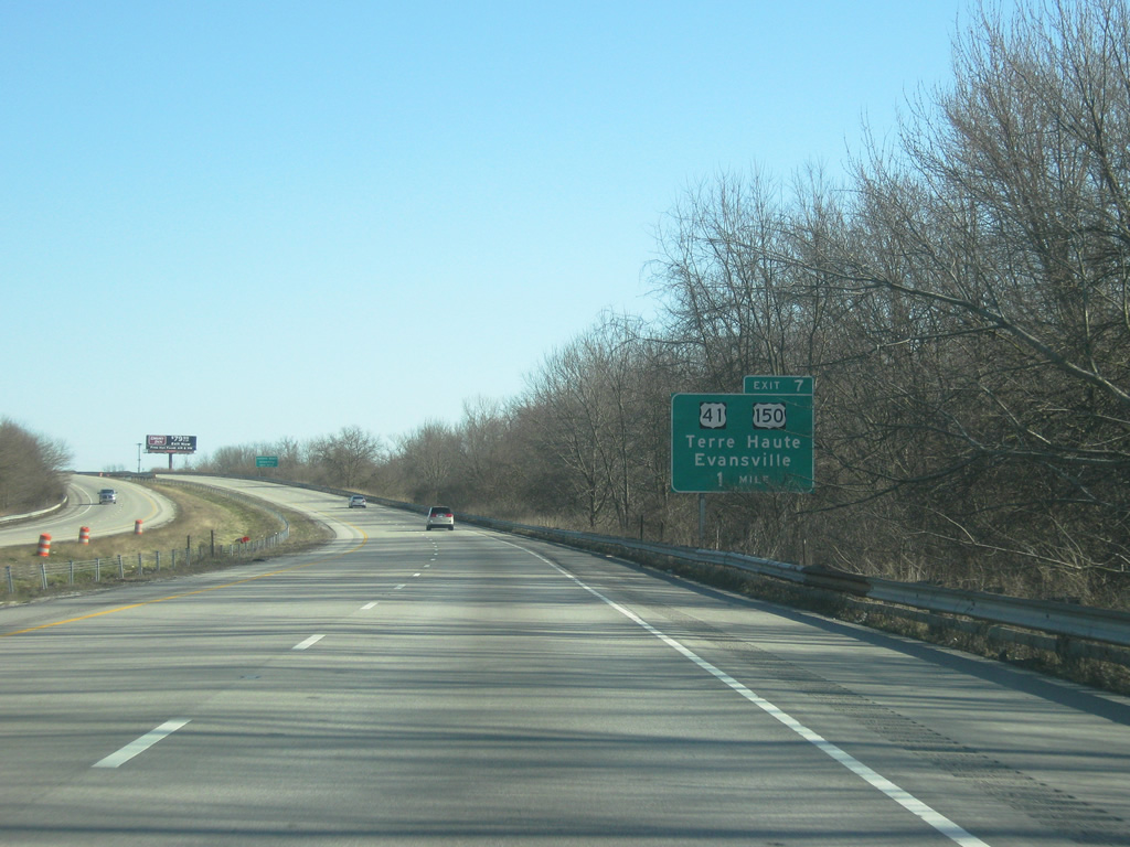
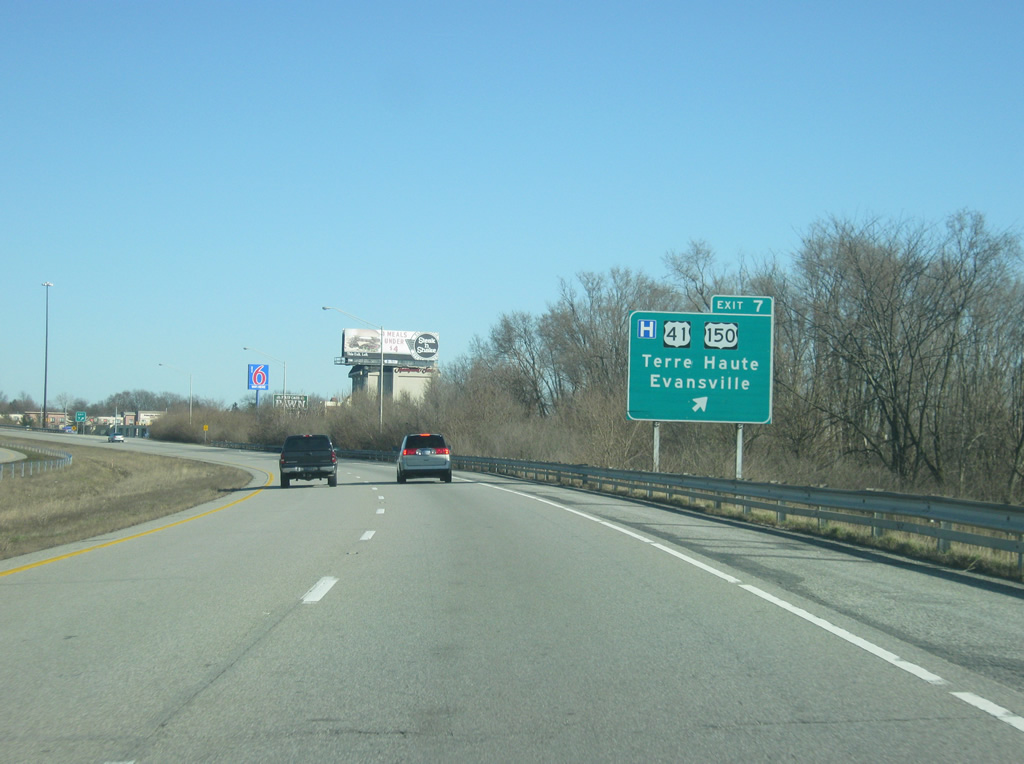
| After crossing the Wabash River, I-70/U.S. 40 east continue a mile to Exit 7 for U.S. 41/150. Comprising a busy divided arterial, U.S. 41/150 lead southward from Honey Creek Mall, the County Fairgrounds, and Ivy Tech Community College to suburban areas of Southwood, Allendale, and Woodgate, meeting SR 641 at Youngstown. 03/18/12 |
|
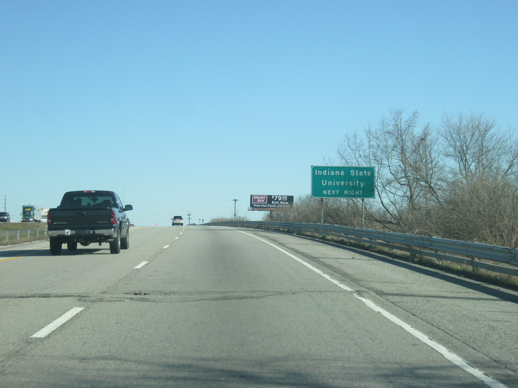
| Indiana State University, home of the Sycamores, is located in Downtown Terre Haute along U.S. 41/150 (3rd Street) a couple of miles to the north of Exit 7 with I-70/U.S. 40 east. Until its realignment, U.S. 40 passed by the southern boundary of the university. 03/18/12 |
|
| U.S. 41/150 continue along 3rd Street into Terre Haute en route to downtown and Indiana State University. Once in downtown, U.S. 150 splits with U.S. 41 (3rd Street) for former U.S. 40 (Cherry Street) west to Taylorville and West Terre Haute. Continuing north, U.S. 41/SR 63 part ways at Maple Avenue on respective paths to Rockville and Clinton. SR 63 used to run concurrent with U.S. 41 southward to Huffman Street west. However that overlap was removed when SR 63 from Huffman Street to Lombardi Road in the Terre Haute area was decertified in 2008. 03/18/12 |
|
| I-70/U.S. 40 east at the Exit 7 ramp departure to U.S. 41/150 (3rd Street). U.S. 41/150 constitute a four lane corridor southward to Vincennes (U.S. 50). U.S. 41 continues from there to Evansville and overall to Miami, Florida. Northward U.S. 41 straddles the state line to Gary and Chicago, Illinois. Numerous motorists' services are available around Exit 7 including the Honey Creek Mall. 03/18/12 |
|
| East of Exit 7 and U.S. 41/150, Exit 11 for SR 46/U.S. 40 east is four miles away. Brazil and Indianapolis are 19 and 73 miles away respectively. 03/18/12 |
|
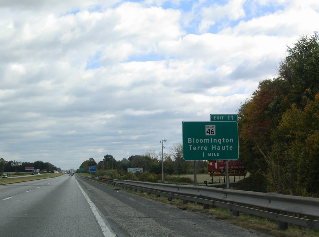
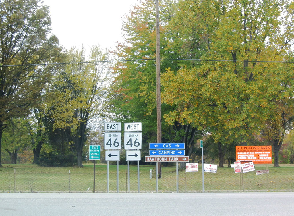
| Traveling along the south side of Terre Haute, motorists approach the last of the Terre Haute exits, that with SR 46 (Exit 11) east and the split with U.S. 40. SR 46 begins and travels southeast to Riley as U.S. 40 follows the former state road alignment northward to its original path along Wabash Avenue. 10/16/04, 03/18/12 |
|
| One half mile west of the off-ramp (Exit 11) to SR 46 and U.S. 40 east. SR 46 travels 153 miles overall to U.S. 52 by Interstate 74 (Exit 169) near the Ohio state line. Bloomington is about 55 miles away to the southeast along SR 46. 10/16/04, 03/18/12 |
|
| Eastbound Interstate 70 at the Exit 11 loop ramp to U.S. 40 east and SR 46 east. This interchange will be upgraded to a directional cloverleaf interchange in association with the Terre Haute Bypass (SR 641) project. Crews are building a new 6.2 mile freeway from Interstate 70 south to U.S. 41/150 at Youngstown. Construction on the $158 million project continues through late 2014. 10/16/04, 03/18/12 |
|
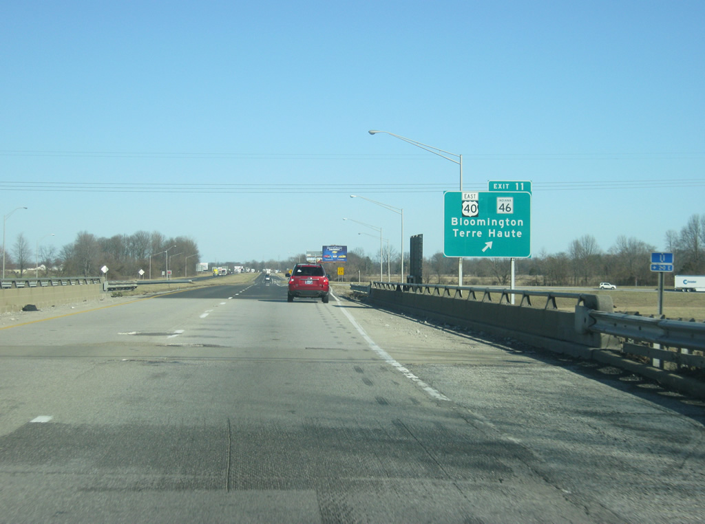
| SR 46 shields posted at the end of the original Exit 11 off-ramp. SR 46 will likely see truncation from Interstate 70 southward to a new diamond interchange on SR 641 at Riley Road. The state road was shortened when U.S. 40 was relocated from Wabash Avenue south onto the freeway in January 2011. 10/16/04 |
|
| East of Exit 11, Brazil is 15 miles away. The Putnam County seat of Greencastle is the next major community at 37 miles with Indianapolis at 68 miles. Under good driving conditions, the Circle City of Indianapolis is about an hour away from this point. 03/18/12 |
|
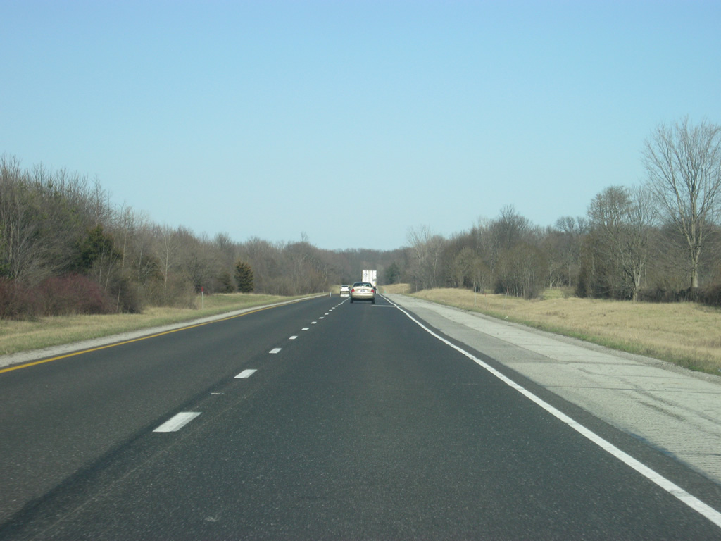
| Now east of Terre Haute, Interstate 70 passes through the eastern part of Vigo County toward the Clay County line. To the north, SR 42 parallels the highway, as it will for most of the journey toward Indianapolis. Interstate 70 took much of the traffic off of U.S. 40 to the north, but the highway follows SR 42 more closely. 03/18/12 |
|
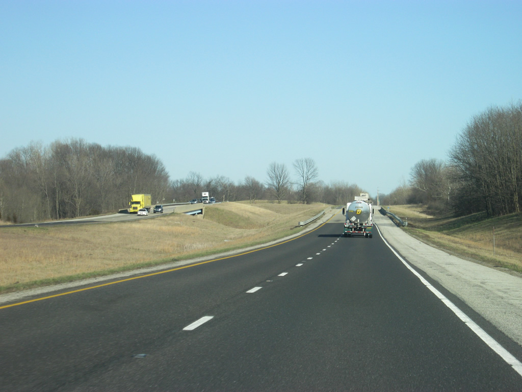
| Interstate 70 enters Clay County near the 16 mile marker and passes underneath SR 42 in the third picture. There is no interchange with SR 42 along Interstate 70. 03/18/12 |
|
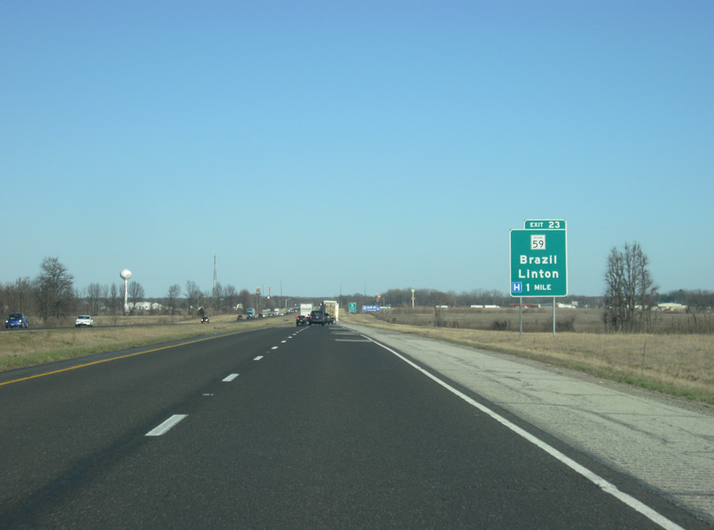
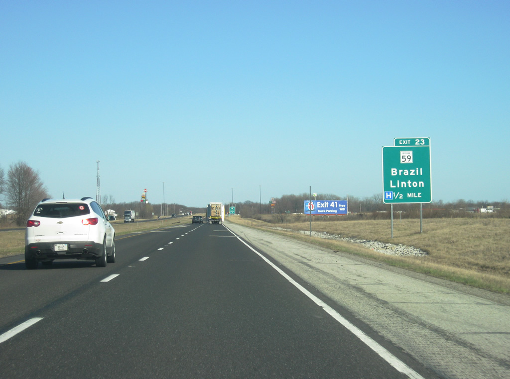
| The lone Clay County exit of Interstate 70 is the Exit 23 diamond interchange with SR 59 near Prairie City. 03/18/12 |
|
| Interstate 70 is one half mile west of the Exit 23 off-ramp to SR 59. SR 59 constitutes a 79.7 mile route between Sandborn and Waveland. In 1968, INDOT unsuccessfully lobbied for an Interstate 63 corridor leading south from the Brazil area to Evansville to provide a route between Indianapolis and southwest Indiana. Construction of Interstate 164 was a result of that original proposal. 03/18/12 |
|
| Heading north, SR 59 ventures four miles to Billville and the Clay County seat of Brazil. Southward the state road immediately intersects SR 42 by Prairie City before continuing south to Clay City and Linton in Greene County. A few truck stops surround the otherwise rural cross roads. 03/18/12 |
|
| Putnamville (located north of Exit 37 along SR 243) is 16 miles away. Greencastle and Indianapolis are respectively 23 and 58 miles away. 03/18/12 |
|
| Late winter scenery along the hilly stretch of Interstate 70 between Exits 23 and 37, which constitutes the longest distance traveled between exits along Interstate 70 in Indiana. Eastbound travelers enter Putnam County on the drive. At the time of these pictures, construction work had closed one of the eastbound lanes at various points from Exits 23 to 66 as part of a paving project along the interstate. 03/18/12 |
|
| Interstate 70 finally reaches the one mile approach to the Exit 37 diamond interchange with SR 243. 03/18/12 |
|
| A half mile away from Exit 37 with SR 243. SR 243 meanders southward to its end at SR 42 at Cunot near Cagles Mill Lake. 03/18/12 |
|
| Lieber State Recreational Area, named for the father of the Indiana state park system, surrounds Cagles Mill Lake to the south off of SR 243 along the Putnam-Owen County line. 03/18/12 |
|
| Exit 37 departs from Interstate onto SR 243. Continuing north from Exit 37, SR 243 concludes its five mile route at U.S. 40 at Putnamville. 03/18/12 |
|
| East of Exit 37, Cloverdale (located just south of Exit 41 off of U.S. 231) is three miles away. Mooresville (a southwestern suburb of Indianapolis) is 33 miles away while Indianapolis is further east at 44 miles. 03/18/12 |
|
| A view of Interstate 70 eastbound in between the two Putnam County exits at SR 243 and U.S. 231. 03/18/12 |
|
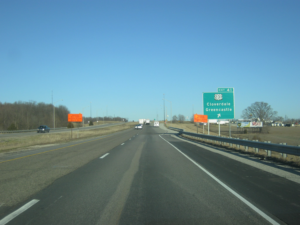
| U.S. 231 intersects Interstate 70 at a diamond interchange (Exit 41) in southeast Putnam County. The north-south route joins the freeway with Cloverdale nearby and travels 297 miles in Indiana between St. John (U.S. 41) and the Kentucky state line. 03/18/12 |
|
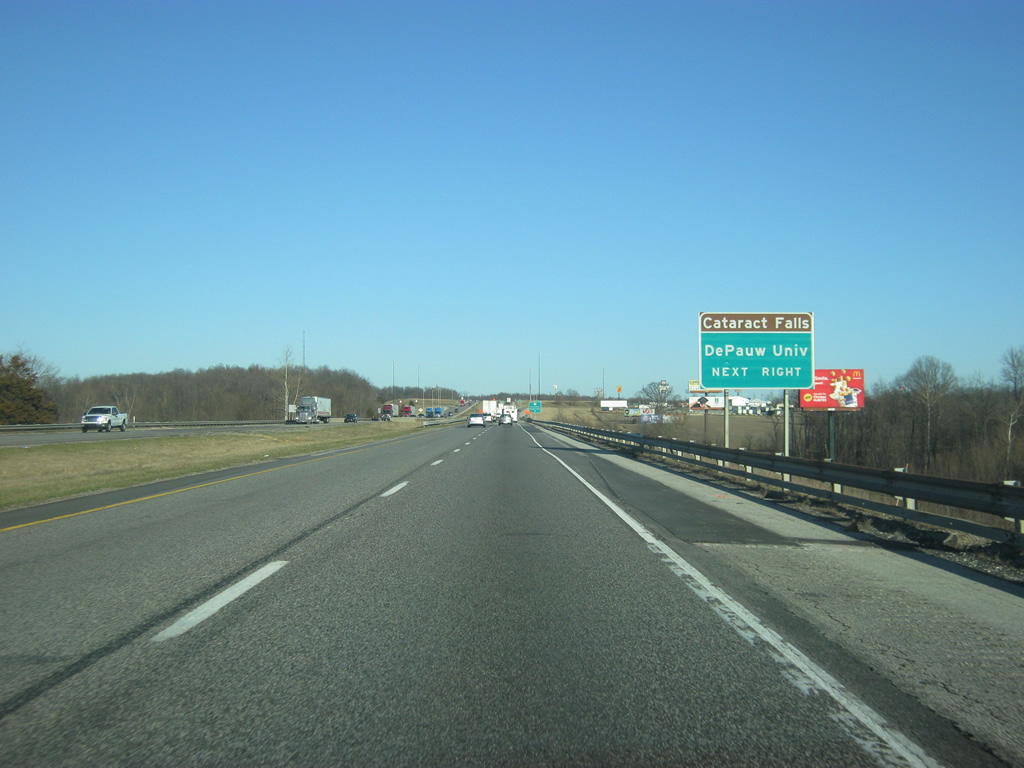
| Eastbound Interstate 70, a half mile out from U.S. 231, which is a major north-south corridor across western Indiana, heading south toward Spencer, the Crane Naval Warfare Center and Jasper and north past Greencastle toward Crawfordsville and Lafayette. DePauw University is located to the north in Greencastle while Cataract Falls is located to the south in northern Owen County. 03/18/12 |
|
| Drivers bound for U.S. 231 north to Greencastle or U.S. 231 south to Cloverdale leave Interstate 70 west at the Exit 41 off-ramp. McCoy Hill rises along the north side of the freeway. Several motorists' services are located at Exit 41 which represents the unofficial halfway point between Terre Haute and Indianapolis. 03/18/12 |
|
| An Interstate 70 reassurance shields greets motorists east of Exit 41 with U.S. 231. County Road 1100 West, located in northwestern Morgan County is the next exit at nine miles. Plainfield (another southwestern suburb of Indianapolis) is 29 miles away with Indianapolis ten miles beyond that. 03/18/12 |
|
| Intestate 70 continues in an east-northeast direction toward the Putnam-Morgan County line and the greater Indianapolis area. 03/18/12 |
|
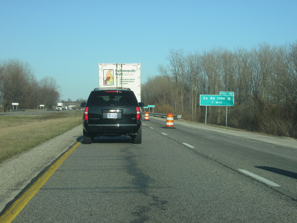
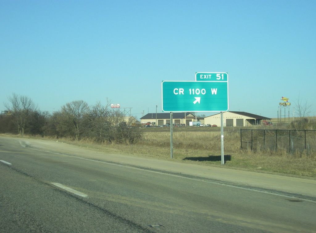
| Still in Putnam County, but only feet from the county line, Interstate 70 is one mile from Exit 51 for County Road 1100 West. 03/18/12 |
|
| Interstate 70 crosses Mill Creek and enters the northwestern corner of Morgan County at the half mile approach to Exit 51 for County Road 1100 West, which is spelled out with the abbreviation "CR" instead of "Co. Rd." as on the previous sign. 03/18/12 |
|
| A diamond interchange joins Interstate 70 with County Road 1100 West just north of Little Point and SR 42. North Little Point Road connects with County Road 550 West to Stilesville in southwestern Hendricks County. SR 42 meanwhile continues to follow Interstate 70 to the south as it heads east toward Monrovia and south toward Eminence. 03/18/12 |
|
| Monrovia is the next community (via SR 39 off of Exit 59) at 11 miles in distance. Mooresville is 19 miles away with Indianapolis at 30 miles. It's about a half-hour drive to the center of Indianapolis at this point. 03/18/12 |
|
| Interstate 70 in between Exits 51 and 57 heads through more of the typical Central Indiana terrain of agricultural fields as it leaves the hillier terrain of Putnam County. Interstate 70 will remain on mostly flat ground for at least the next 200 miles until the highway passes Columbus, Ohio. In the second picture, the interstate enters Hendricks County for the first time. 03/18/12 |
|
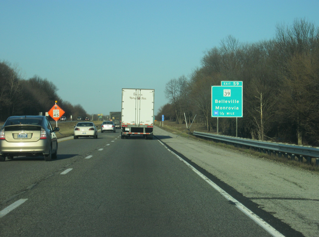
| SR 39 crosses paths with Interstate 70 at a diamond interchange (Exit 59) near Center Valley. The state road connects the freeway with Monrovia 2.7 miles southward and Belleville (U.S. 40) 3.3 miles to the north. 03/18/12 |
|
| Consisting of two sections, SR 39 exists between Martinsville and the Michigan state line as a 179.2 mile route, meeting Interstate 70 at Exit 59. The southern portion travels just 15.5 miles between SR 56 and Brownstown in Jackson and Scott Counties. 03/18/12 |
|
| Exit 59 leaves Interstate 70 east for SR 39. SR 39 travels south to SR 37 (future Interstate 69 corridor), merging with SR 67 outside Martinsville. The state road north serves the county seat of Danville between U.S. 40 and U.S. 136. 03/18/12 |
|
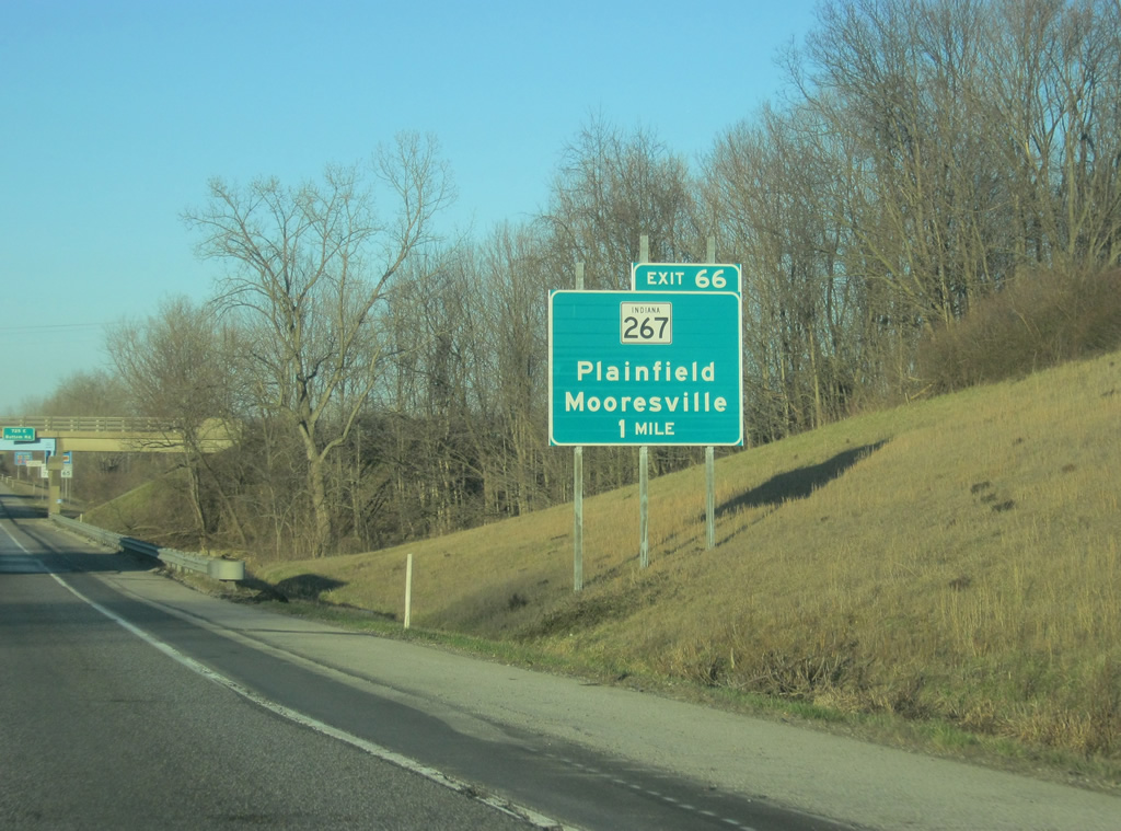
| The Hendricks County suburb of Plainfield is 11 miles away via the next interchange with SR 267. The Interstate 465 beltway is 13 miles away (the exit that is, not the highway itself) with Indianapolis 21 miles away. 03/18/12 |
|
| Passing back into Morgan County briefly before heading back into southeastern Hendricks County, Interstate 70 is at the two mile approach to the Plainfield rest area. The next rest area is 46 miles away east of Greenfield. 03/18/12 |
|
| Now a mile away from the Plainfield rest area off of Interstate 70, which serves motorists heading east before they enter the Indianapolis metropolitan area. 03/18/12 |
|
| The exit ramp onto the Plainfield rest area turns off of Interstate 70. 03/18/12 |
|
| Continuing east from the rest area, drivers next meet SR 267 (Quaker Boulevard) south of Plainfield and north of Mooresville. 03/18/12 |
|
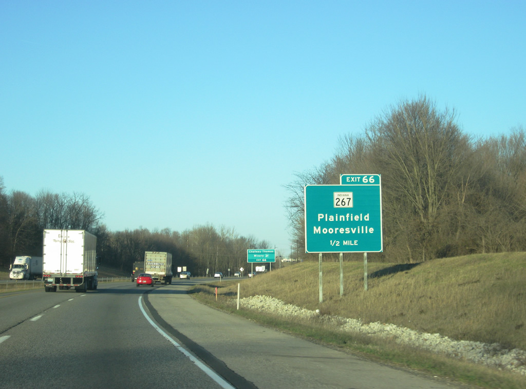
| SR 267 leads north from Exit 66 through an industrial area to its merge with U.S. 40 (Main Street) east of downtown Plainfield. To the south, the highway meanders for seven miles to its southern terminus at SR 42 in downtown Mooresville in northeastern Morgan County. 03/18/12 |
|
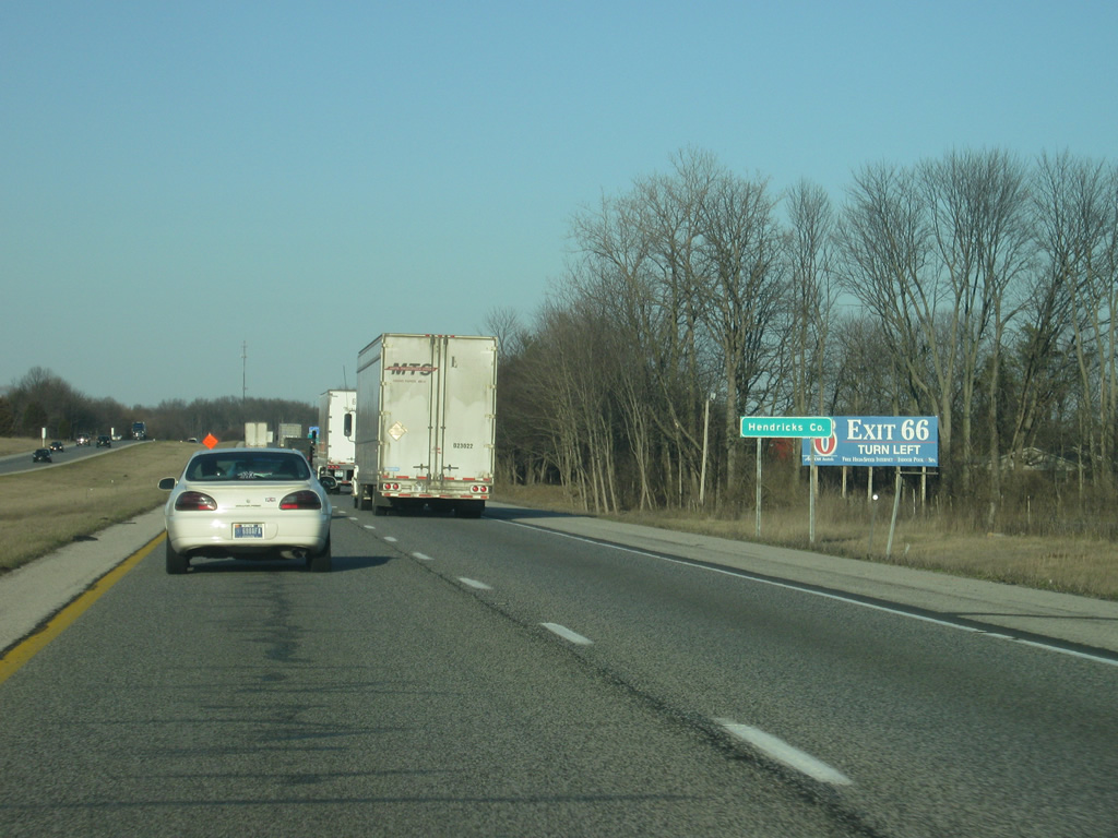
| Interstate 70 eastbound at the diamond interchange (Exit 66) with SR 267. The state road travels 28.7 miles between Mooresville (SR 42) and Interstate 65 south of Whitestown. To the north, SR 267 provides access to the sprawling industrial park that abuts Interstate 70 to the north as well as the Metropolis Mall, an outdoor lifestyle center serving Hendricks County. Exit 68 for Ronald Reagan Parkway and Ameriplex Parkway, along with the entrance to the Indianapolis International Airport is two miles away. 03/18/12 |
|
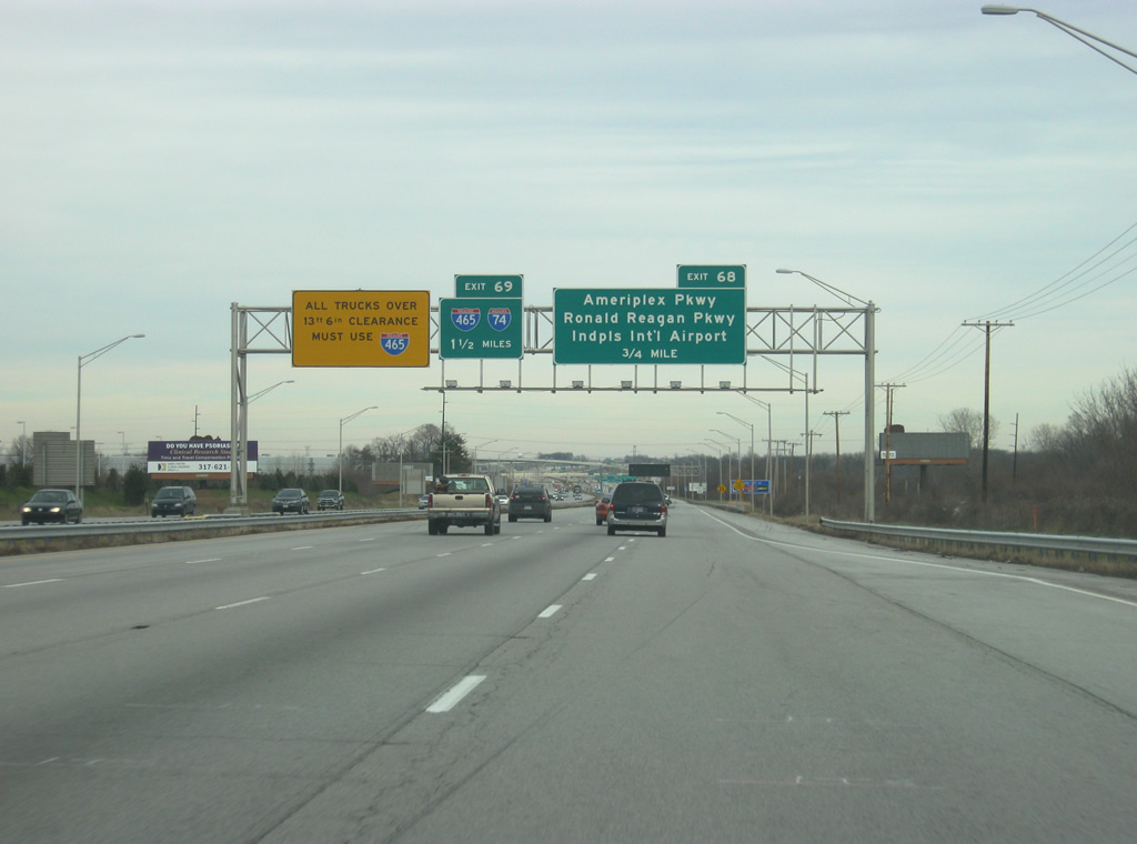
| Approaching the Exit 68 collector distributor roadway split from Interstate 70 eastbound near Plainfield. Exit 68 consists of a six-ramp parclo interchange with Ronald Reagan Parkway north and Ameriplex Parkway south and a directional interchange with Colonel H. Weir Cook Memorial Drive, the access road for the Indianapolis International Airport, north. Up ahead in a 1 1/2 miles is the ramp for I-465/74. 11/05/09, 12/22/11 |
|
| Interstate 70 eastbound expands to three lanes from the State Road 267 on-ramp to the Exit 68 collector distributor roadway. White advisory signs indicate that hazardous materials based cargo must use the Indianapolis Beltway in lieu of Interstate 70 through the city. 12/22/11 |
|
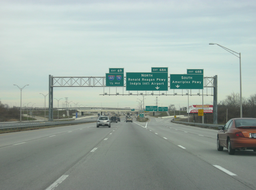
| The collector distributor roadway carries two overall lanes to the Ronald Reagan and Ameriplex Parkways and Indianapolis International Airport (IND) access road. A slip ramp follows in three quarters of a mile for interests onto I-465/74 (Exit 69). 11/05/09, 12/22/11 |
|
| Exit 68 leaves the Interstate 70 eastbound mainline and partitions into separate ramps for Ameriplex Parkway south and Ronald Reagan Parkway north. The collector distributor roadway continues to the directional cloverleaf interchange with the Indianapolis Beltway (Exit 73). 11/05/09, 12/22/11 |
|
| Exit 68B immediately parts ways with the c/d roadway for Ameriplex Parkway south to SR 67 (Kentucky Avenue). The parkway serves areas bound by Interstate 70 and State Road 67, near Maple Ridge and Valley Mills, slated for a large industrial park. 11/05/09 |
|
| A second advisory sign indicates through traffic carrying hazmats to use Interstate 465. Ramps to the beltway (Exit 73) depart over the next four miles. 11/05/09 |
|
| Up ahead, the right two lanes will enter the collector distributor ramps to I-465/74. To the right, a loop ramp shuttles vehicles onto Ronald Reagan Parkway northbound to Six Points. The multi-lane highway replaced Six Points Road when it was built in conjunction with the Interstate 70 redesign at Indianapolis International Airport in the mid-2000s.
Ronald Reagon Parkway opened between County Road 100 South and U.S. 36 on December 4, 2012, providing a seamless route between I-70 and Avon.1 Further plans for the north-south corridor extend the roadway northward from its end at County Road 300 North to Interstate 74 at Brownsburg and Interstate 65 near Whitestown. A portion of parkway links I-74 with U.S. 136 and County Road 600 North at present. 11/05/09, 12/22/11 |
|
| Eastbound travelers cross into Marion County and the city of Indianapolis midway between the Ronald Reagan Parkway ramps and the flyover for Colonel H. Weir Cook Memorial Drive north. 11/05/09 |
Page Updated 08-07-2012.


 East
East