|
| SR 725 (Miamisburg Centerville Road) meets Interstate 75 at Exit 44, one mile north of I-675 in a commercial area anchored by Dayton Mall. 11/13/04 |
|
| SR 725 comprises an arterial west to Central Avenue and Downtown Miamisburg and east onto Franklin Street in the city of Centerville. 11/13/04 |
|
| Interstate 75 north enters the Miamisburg city limits at the diamond interchange (Exit 44) with SR 725 (Miamisburg Centerville Road). A 48.07 mile long route, SR 725 extends west to Indiana State Road 44 beyond Camden and east to U.S. 42 by Spring Valley.1 11/13/04 |
|
| Continuing north, Interstate 75 advances into the city of West Carrollton by Cox Arboretum MetroPark. The succeeding exit is for E Dixie Drive, the historic alignment of U.S. 25. 11/13/04 |
|
| Dixie Drive (old U.S. 25) connects with SR 741 (Springboro Pike) to the east, where the arterial partitions into a couplet with Kettering Boulevard in the city of Moraine. 11/13/04 |
|
| The exchange at Dixie Drive was originally designed as the north end of a limited access highway connecting Dayton with Cincinnati. The partial interchange remained after the completion of I-75 north. Road work in 2011/12 rebuilt Exit 47 as a diamond interchange.2 11/13/04 |
|
| Dixie Drive continues north along the Kettering city line onto Patterson Boulevard in Dayton. Parallel SR 741 heads north from Dixie Drive to the Fuyao Glass America plant, which formerly was the GM Moraine Facility. 11/13/04 |
|
| Dryden Road stems north from Dixie Drive into an industrial area in the city of Moraine en route to the parclo interchange at Exit 50 A. 11/13/04 |
|
| Interstate 75 diverges from the parallel Great Miami River east ahead of Exit 50 to Dryden Road. Dryden Road extends north across the river onto Broadway Street in Dayton. 11/13/04 |
|
| A $47.3 million project reconstructing a 2.71 mile long section of I-75 from Summer 2022 to Summer 2025 includes improvements at the exchange (Exit 50 A) with Dryden Road.3 Exit 50 B is a half diamond interchange joining the north end of SR 741 (Springboro Pike) with Interstate 75 nearby. 11/13/04 |
|
| Exit 51 joins Interstate 75 with Edwin C. Moses Boulevard just across the Great Miami River in Dayton. 11/13/04 |
|
| Edwin C. Moses Boulevard runs along the Great Miami River northeast from University of Dayton Arena nearby to Washington Street near Downtown. Nicholas Boulevard extends the boulevard west to Gettysburg Avenue. 11/13/04 |
|
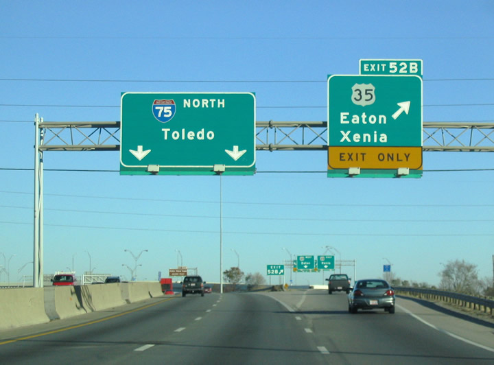
| Exit 51 leaves I-75 north for Edwin C. Moses Boulevard one mile ahead of the systems interchange (Exit 52) with the freeway along U.S. 35/SR 4. 11/13/04 |
|
| Meeting I-75 at Exit 52, U.S. 35 travels east across Dayton along a freeway from Abbey Avenue to Factory Road on the east side of Beavercreek. 11/13/04 |
|
| SR 4 overlaps with U.S. 35 west from I-75 to Gettysburg Avenue in Dayton. U.S. 35 continues from there to the city of Trotwood. 11/13/04 |
|
| Part of the I-75 Modernization Project started in 2007, work along I-75 by Downtown Dayton underway from 2011 to 2016 expanded the freeway to six overall lanes. Construction also eliminated the half diamond interchange (Exit 52 A) with Albany Street. A ribbon cutting ceremony marking completion of the project took place on September 22, 2016.4 11/13/04 |
|
| Phase 2 of the Downtown Dayton Sub-Corridor project consolidated the ramp system between W 3rd Street and Monument Avenue (old SR 49) into overlapping diamond interchanges. Costing an estimated $390 million,5 construction was completed in 2016. 11/13/04 |
|
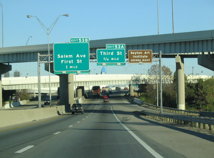
| Exit 53 links I-75 northbound with Maxwell Drive north at Salem Avenue on the west side of Downtown. Points if interest include Sinclair Community College, Day Air Ballpark (home of Dayton Dragons Minor League Baseball) and Dayton Aviation Heritage National Historical Park. 11/13/04 |
|
| Exit 53 A formerly departed above the Great Miami River onto 3rd Street with an access road to 1st Street. Exit 53 B joined 1st Street and Monument Avenue, which formerly were part of SR 49. 11/13/04 |
|
| Salem Avenue angles northwest through Dayton to Fort McKinley and Trotwood along the former route of SR 49. SR 49 was relocated onto an expressway bypass south from Salem Avenue to U.S. 35 at W 3rd Street. 11/13/04 |
|
| Interstate 75 crosses the Great Miami River for a third time ahead of Exit 54 A to SR 48 (Main Street) and Exit 54 B for the continuation of SR 4 to Riverside and Huber Heights. 11/13/04 |
|
| The I-75 Modernization Project eliminated the exchange joining Riverside Drive with I-75 and reconfigured Exit 54 A into a diamond interchange with SR 48 (Main Street). SR 48 heads south into Downtown Dayton and north to Shiloh and Clayton. 11/13/04 |
|
| SR 4 combines with I-75 north from U.S. 35 to a directional T interchange spanning the Great Miami River by Deeds Point MetroPark. Paralleling the Mad River, SR 4 travels northeast from Dayton to Wright Patterson A.F.B. at the Greene County line. 11/13/04 |
|
| Exit 54 C to SR 4 north connects with Webster Street beyond the Great Miami River. Formerly part of U.S. 25 south to 3rd Street, Webster Street spans the Mad River to Monument Avenue, one block from Day Air Ballpark. 11/13/04 |
|
| A loop ramp formerly joined I-75/SR 4 north from Riverside Drive adjacent to the fourth crossing of the Great Miami River. SR 4 angles northeast from Exit 54 C to Riverside, Huber Heights and an overlap with I-70 east to Springfield. 11/13/04 |
|
| Part of $180 million in work from October 19, 2007 to June 2011, the original roadways for I-75 across the Great Miami River were repurposed as extended ramps with SR 4 by Kettering Field. The improvements at the exchange referenced as "Malfunction Junction" included adding three lane roadways for I-75 that run side by side. These eliminated the previous sharp curve.7 11/13/04 |
|
| SR 4 heads 5.2 miles east to SR 444 at Wright Patterson AFB and 10.6 miles to I-70 at Huber Heights. Overall the state route travels 207.22 miles from U.S. 42 in Cincinnati to U.S. 6/SR 101 in Sandusky.6 11/13/04 |
|
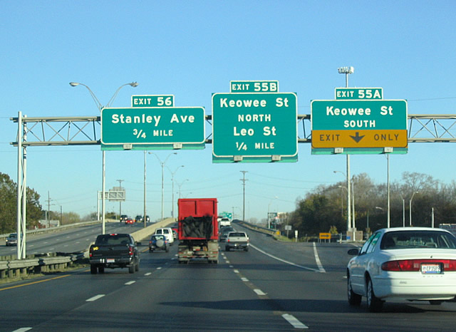
| Keowee Street stems north from Wayne Avenue and the freeway along U.S. 35 across the Mad River to SR 201 (Valley Street) and SR 4. Exit 55 B previously joined I-75 north with Keowee Street (old U.S. 25) southbound. Ramps at Exit 55 were removed during Phase 1A of the I-75 Modernization Project.7 11/13/04 |
|
| Exit 55 B was a slip ramp onto adjacent Hillrose Avenue north ahead of Leo Street. Leo Street heads west to Keowee Street (old U.S. 25) and east to Webster Street where the Chrysler Corp Dayton Thermal Production plant was located. 11/13/04 |
|
| Construction between October 2007 and June 2011 eliminated two ramps along I-75 southbound at the parclo interchange (Exit 55 C) with Stanley Avenue. The Stanley Avenue Project of the Modernization of I-75 through Downtown Dayton cost $17 million.7 11/13/04 |
|
| Stanley Avenue arcs through an industrial area adjacent to the Great Miami River east from Helena Street to SR 202 (Troy Street) and SR 201 (Brandt Street). Both state routes run northeast from Dayton to Riverside and Huber Heights. 11/13/04 |
|
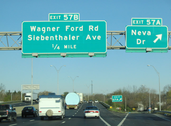
| Shifting westward, I-75 spans the Great Miami River for the fifth and final time ahead of the former half diamond interchange (Exit 57 A) with Neva Drive. Ramps at Exit 57 A were eliminated as part of the Stanley Avenue Project.7 11/13/04 |
|
| Interstate 75 enters the unincorporated community of Northridge ahead of Neva Drive. Neva Drive spurs east into a residential area and connects with parallel N Dixie Drive (old U.S. 25) to the west. 11/13/04 |
|
| Wagner Ford Road heads 2.2 miles northeast from Dixie Drive to Dayton Raceway and Needmore Drive by the former Kittyhawk Golf Center. The city of Dayton closed Kittyhawk Golf Center to cut costs in May 2020. The course began operations in 1961.8 11/13/04 |
|
| The original construction of Interstate 75 directly replaced U.S. 25 along Dixie Drive north from Keats Drive. A diamond interchange next joins I-75 with Needmore Road at Exit 58. 11/13/04 |
|
| A multi lane boulevard, Needmore Road runs 2.3 miles east to SR 202 (Old Troy Pike) at Hooks Corner in northeast Dayton and 1.2 mile west to become Shoup Mill Road north of Wegerzyn Gardens MetroPark and ahead of Shiloh. 11/13/04 |
|
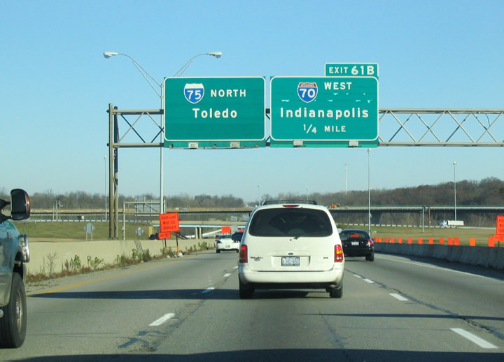
| Costing $145 million, reconstruction of the I-70/75 interchange at Exit 61 commenced in March 20029 The exchange was dedicated as the Freedom Veterans Crossroads on October 25, 2004 to honor Ohioans serving in the military.10 11/13/04 |
|
| Part of the I-70/75 interchange reconstruction project underway from 2002 to 2008, the Benchwood/Wyse Interchange links I-75 with Benchwood Road west and Wyse Road east at Exit 58. Those ramps replaced RIRO ramps with Poe Avenue and Miller Lane south of Little York Road.9 11/13/04 |
|
| Impressions of the Wright "B" Flyer, acknowledging the Wright Brother's first flight, join images of Apollo 11, the Lunar Module and others acknowledging Dayton as the "birthplace of aviation" on retaining walls built during the I-70/75 interchange reconstruction.9,10 11/13/04 |
|
| Little York Road meanders west from Vandalia to Murlin Heights and Clayton in Butler Township south of Interstate 70. Stop 8 Road parallels Benchwood Road 0.6 miles to the south. 11/13/04 |
|
| Interstate 70 stays north of Dayton, passing through the suburbs of Clayton, Vandalia and Huber Heights. The turbine interchange at Exit 61 replaced a cloverleaf. 11/13/04 |
|
| The loop ramp at Exit 61 B was replaced with a half mile long high speed flyover.9 I-70/75 Interchange Phase III reconstructed I-70 from west of the Dayton Airport Access Road to the CSX Railroad. Work built the remaining ramps with I-75 and constructed a new railroad bridge over I-70 to the east. The estimated $48.3 million in road work ran from Spring 2005 to May 2011.11 11/13/04 |
|
| I-70 travels 1.6 miles west from I-75 to the Dayton International Airport Access Road freeway to the passenger terminal at DAY Airport. Richmond, Indiana lies 34 miles to the west followed by I-69/465 in Indianapolis in 100 miles. 11/13/04 |
Page Updated 03-21-2024.