|
| Hutchinson River Parkway extends north from the end of I-678 to Exit 1 for Bruckner Boulevard west. Bruckner Boulevard constitutes the frontage street system for I-278 west to the RFK Bridge and I-95 north to Pelham Bay Park. 06/13/05 |
|
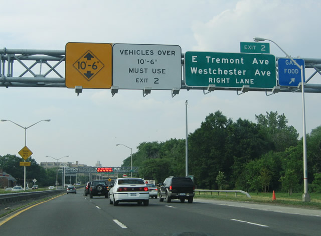
| Exit 2 departs Hutchinson River Parkway north for Tremont and Westchester Avenues in the Westchester neighborhood of the east Bronx. Vehicles exceeding 10 foot 6 inches in height are prohibited north of Exit 2 due to the Westchester Avenue overpass. 06/13/05 |
|
| Exit 2 links with Ericson Place north one block to Tremont Avenue and six blocks to Westchester Avenue. Tremont Avenue heads west to the Parkchester community. Westchester Avenue angles northeast to Pelham Bay. 06/13/05 |
|
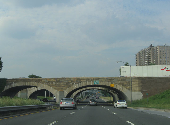
| Hutchinson River Parkway passes through a short tunnel below Herbert H. Lehman High School ahead of Tremont Avenue. 06/13/05 |
|
| Hutchinson River Parkway north at the Westchester Avenue and MTA #6 transit line over crossing. 06/13/05 |
|
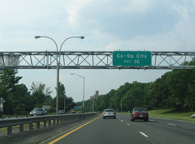
| Co-Op City lies between I-95 (New England Thruway) and the Hutchinson River. There is no direct access from the parkway to the community, so motorists are directed onto Bronx Pelham Parkway east to I-95 north via Exit 3E. 06/13/05 |
|
| A cloverleaf interchange joins Hutchinson River Parkway with Bronx Pelham Parkway at Exits 3E/W. 06/13/05 |
|
| Bronx Pelham Parkway constitutes a controlled access arterial between U.S. 1 (Fordham Road) at Bronx River Parkway and Interstate 95 at Shore Road. 06/13/05 |
|
| Exit 3W loops onto Bronx Pelham Parkway west between Pelham Gardens and Morris Park to the cloverleaf interchange joining U.S. 1 (Fordham Road) with Bronx River Parkway. Fordham Road extends west to Belmont and Fordham University. 06/13/05 |
|
| Ramps connect I-95 (New England Thruway) with Hutchinson River Parkway one mile ahead of Exit 5 for Orchard Beach and City Island. 06/13/05 |
|
| Stone arch bridges carry Interstate 95 (New England Thruway) / Gun Hill Road across Hutchinson River Parkway. Exits 4N/S link the parkway southbound with Baychester Avenue and I-95 south here. 06/13/05 |
|
| Constructed as a middle income housing project, Co-op City includes 15,000 apartment units spread across 30 high-rises.1 06/13/05 |
|
| Built upon reclaimed swamp land, the site of Co-Op City was once considered for Curtis Airfield, a post-WWII military installation.1 06/13/05 |
|
| Confirming marker for Hutchinson River Parkway posted after the entrance ramp from I-95 and Palmer Avenue at Co-Op City. 06/13/05 |
|
| Exit 5 serves the Orchard Beach area of Pelham Bay Park via connections east of Bartow Pell Circle. City Island lies east of the park between Eastchester Bay and Long Island Sound. 06/26/05 |
|
| Crossing the Hutchinson River northbound between Bartow Avenue and Exit 5. 06/26/05 |
|
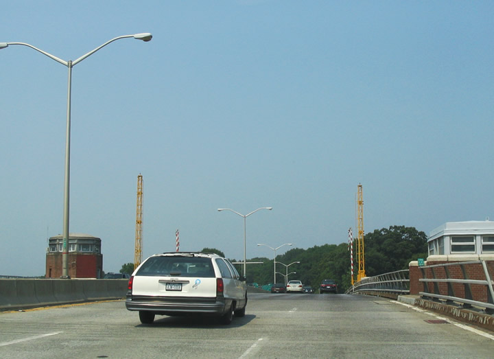
| Opened in 1941 and reconstructed in 1985, the single-leaf bascule bridge passes 35 feet above the Hutchinson River. The span carries six lanes of traffic with a sidewalk along the west side.2 06/26/05 |
|
| City Island was first settled by the Siwanoy Indians and later established as an English settlement in 1685. City Island was a supply and shipbuilding center during the 18th and 19th centuries, expanding that function for the military during World Wars I and II. 06/26/05 |
|
| Interstate 95 and Hutchinson River Parkway cross paths again near the Bronx / Westchester County line at Exit 6. 06/26/05 |
|
| Following the New England Thruway, I-95 shifts east of the Parkway at Exit 6 through Pelham Manor, New Rochelle and Port Chester. 06/26/05 |
|
| U.S. 1 (Boston Post Road) meets Hutchinson River Parkway just north of I-95 at a parclo interchange (Exit 7) in the village of Pelham Manor. 06/26/05 |
|
| U.S. 1 travels northeast from Bronx, New York to New Rochelle, paralleling I-95 into southwest Connecticut. Boston Post Road represents the original route between New York City and Boston, Massachusetts. U.S. 1 was established along the route in 1926. 06/13/05 |
|
| The adjacent Hutchinson River separates Pelham Manor from the city of Mount Vernon. Forthcoming Exit 9 links Hutchinson River Parkway with Wolfs Lane in the village of Pelham. 06/13/05 |
|
| The parclo B2 interchange at Exit 9 joins Wolfs Lane south to Colonial Avenue to Mt. Vernon and north to 1st Street in Pelham. 06/26/05 |
|
| Continuing north along the Mount Vernon and Pelham city line, the parkway next meets E Lincoln Avenue at a parclo interchange (Exit 12). Exit 10 represents the southbound off-ramp to E 3rd Street in Mount Vernon. Exit 11 to Sparks Avenue was removed in improvement project during the 1980s.1 06/13/05 |
|
| Hutchinson River and Parkway are named after Anne M. Hutchinson (1591-1643). Hutchinson pioneered rights of religious freedom during the 17th century in Massachusetts, Rhode Island and later New York. 06/26/05 |
|
| A stone arch bridge takes a CSX Railroad line across Hutchinson River Parkway. 06/13/05 |
|
| Exit 12 departs from Hutchinson Parkway north for adjacent 1st Avenue south of E Lincoln Avenue in Pelham. Lincoln Avenue extends west across North Side in Mt. Vernon. 06/26/05 |
|
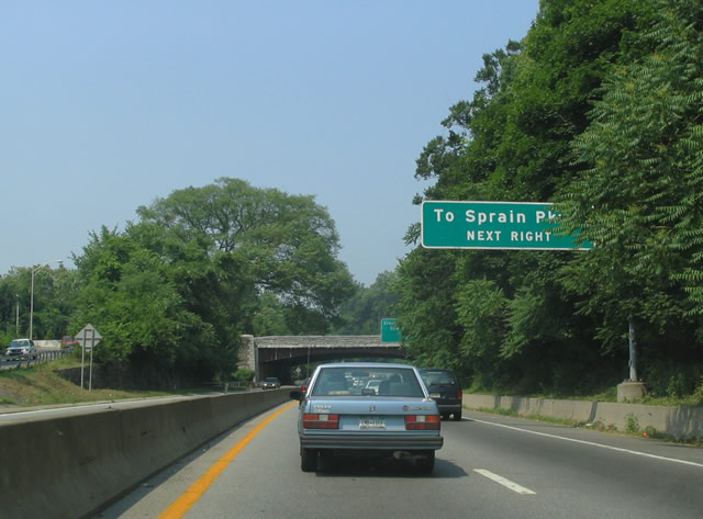
| Exit 13 connects Hutchinson River Parkway north with Cross County Parkway, a limited access highway west to Saw Mill Parkway (NY 9A) in Yonkers. 06/13/05 |
|
| Cross County Parkway connects with Sprain Brook Parkway north along the Bronx River in 1.75 miles. 06/26/05 |
|
| Exit 13 loops onto the access road joining with Cross County Parkway west. The exchange with Interstate 87 (New York Thurway) lies 2.75 miles away in Yonkers. 06/26/05 |
|
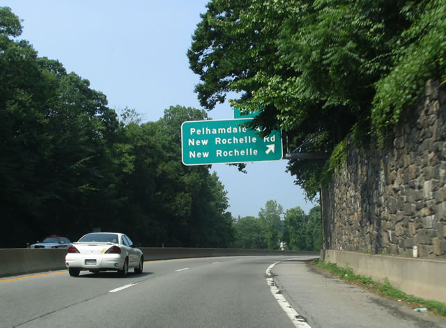
| A folded diamond interchange joins Hutchinson River Parkway with Pelhamdale Avenue south and New Rochelle Road west at Exit 14. 06/13/05 |
|
| The exchange at Exit 14 lies at the corner of the Mount Vernon, Pelham and New Rochelle city line. 06/26/05 |
|
| Cross County Parkway merges with Hutchinson River Parkway at a wye interchange a quarter mile south of Exit 16. 06/26/05 |
|
| Hutchinson River Parkway weaves through Twin Lakes County Park to the wye interchange (Exit 16) with Webster Avenue. Webster Avenue stems south through New Rochelle to Main Street (U.S. 1). 06/13/05 |
|
| Hutchinson River Parkway is six lanes wide north from Cross County Parkway to Exit 17 for North Avenue in New Rochelle. 06/13/05 |
|
| Right side ramps link Hutchinson River Parkway with parallel North Avenue at Exit 17. North Avenue splits into Mill Road west into the unincorporated community of Eastchester and Wilmot Road north to NY 22 (White Plains Road). 06/13/05 |
|
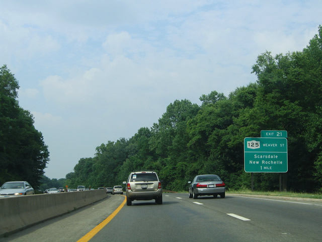
| Turning eastward, Hutchinson River Parkway advances from the Wilmot Road entrance ramp to Exit 21 for Hutchinson Avenue west to NY 125 (Weaver Street). 06/13/05 |
|
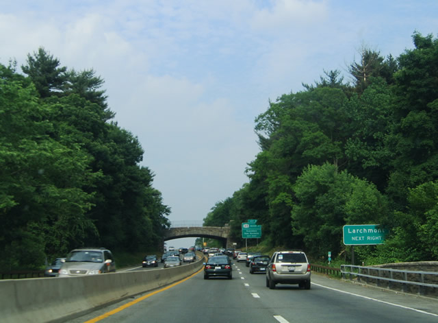
| NY 125 begins at U.S. 1 (Boston Post Road) near Larchmont to the south and ends at NY 119 (Main Street) in White Plains. 06/13/05 |
|
| Exit 21 leaves Hutchinson River Parkway northbound after the Weaver Street overpass. NY 125 straddles the New Rochelle and Scarsdale city line from Quaker Ridge Road and Cornell Street north to Wilmot Road and Heathcote Bypass. 06/13/05 |
|
| A parclo interchange (Exit 22) joins Hutchinson River Parkway with Mamaroneck Road in one half mile. 06/13/05 |
|
| Old White Plains Road extends south from Mamaroneck Road into the town of Mamaroneck. North from Exit 22, Mamaroneck Road continues through Scarsdale one mile to NY 125 (Palmer Avenue) and 2.5 miles to NY 22 (Post Road). 06/13/05 |
|
| Hutchinson River Parkway winds through Saxon Woods County Park to Mamaroneck Road at Exit 23. 06/26/05 |
|
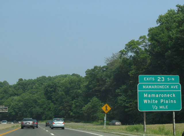
| Entering the three quarter cloverleaf interchange (Exits 23S/N) with Mamaroneck Avenue. 06/13/05 |
|
| Mamaroneck Avenue extends north from Exit 23N to Bloomingdale Road and NY 125 in White Plains. 06/13/05 |
|
| Housing a gas station, the 1930s-built service plaza along Hutchinson River Parkway north is located within the median between Exits 23 and 25 at White Plains. Reconstruction of the parkway through this stretch in the 1980s removed the off-ramp (Exit 24) to West Street.1 06/13/05 |
|
| A diamond interchange joins Hutchinson River Parkway with NY 127 (North Street) at Exit 25. The state route travels south to Downtown Harrison and Mamaroneck (U.S. 1) and north to Interstate 287 (Exit 8) east of Downtown White Plains. 06/26/05 |
|
| Continuing north from NY 127, Hutchinson River Parkway converges with Interstate 287 at a cloverleaf interchange (Exits 26E/W). 06/13/05 |
|
| The Cross-Westchester Expressway leads Interstate 287 east 3.5 miles to I-95 (New England Thruway) at Port Chester and west to the New York Thruway (I-87) at Elmsford. 06/13/05 |
|
| Interstate 684 branches north from Hutchinson River Parkway to Brewster from the ensuing exit beyond I-287 (Cross-Westchester Expressway). 06/13/05 |
|
| Exit 26E leaves Hutchinson River Parkway for a frontage road along I-287 east to Kenilworth Avenue and the freeway to Rye Brook, Port Chester and Rye. 06/26/05 |
|
| Exit 26W connects with Westchester Avenue ahead of I-287 westbound and Corporate Park Drive. I-287 travels through White Plains and Fairview. Combining with I-87, Interstate 287 crosses the Hudson River on the Governor Mario M. Cuomo Bridge between Tarrytown and South Nyack. 06/26/05 |
|
| Interstate 684 splits from Hutchinson River Parkway at an unnumbered wye interchange. I-684 extends 28.4 miles north from Westchester County to I-84 near the village of Brewster. 06/13/05 |
Page Updated 03-08-2020.