|
| A collector distributor roadway system facilitates the movements between Interstate 84 (Wilbur Cross Highway) and Interstates 291 (Exit 61) and 384 (Exit 59). Interstate 384 constitutes an 8.20 mile spur from Interstate 84 east through Manchester to Bolton.
I-384 represents the first section of the planned Hartford to Providence corridor for Interstate 84. Upon cancellation of the I-84 freeway east to Providence, I-84 saw relocation back onto Interstate 86 (Wilbur Cross Highway) toward Sturrbridge, Massachusetts and I-384 was commissioned. 08/09/04 |
|
| Interstate 84 westbound at the merge with U.S. 6 from U.S. 44 (Burnside Avenue) at Exit 60. U.S. 6 & 44 share pavement through the town of Manchester via Center Street to Interstate 84. U.S. 6 joins Interstate 84 westbound from East Hartford through Hartford to Farmington. U.S. 44 meanwhile continues west along Burnside Avenue to Burnside and East Hartford Center. 08/09/04 |
|
| Exit 59 serves not only the eastbound beginning of Interstate 384 but also Silver Lane west to East Hartford and Spencer Street east to Manchester. Exit 59 partitions into ramps for the surface street and I-384 just south of Interstate 84. 08/09/04 |
|
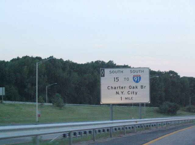
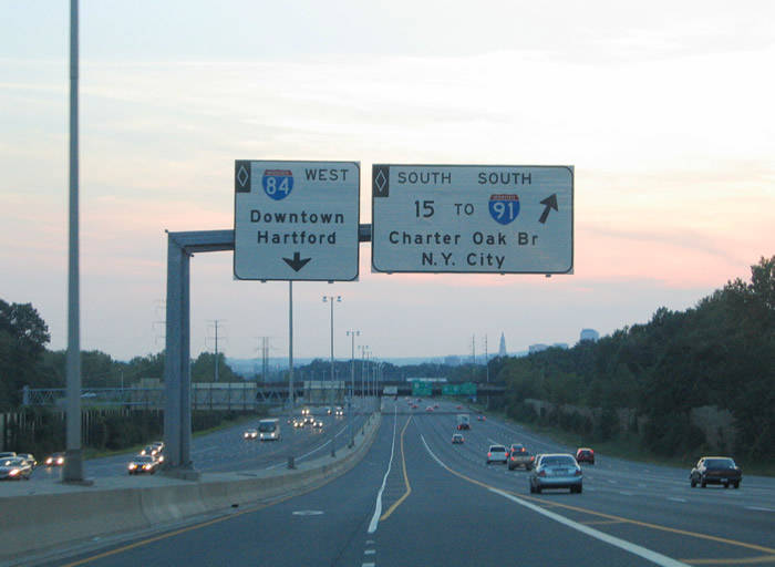
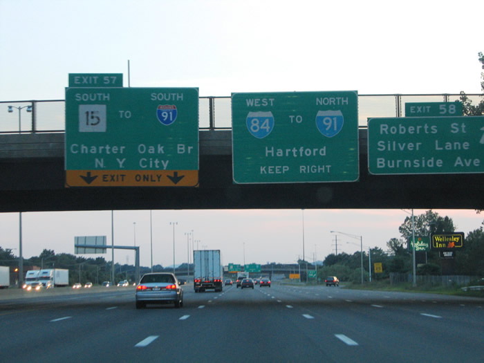
| Interstate 84 includes an HOV-2 dedicated lane in both directions within the Hartford metropolitan area. The car pool lane occupies the left lane of both directions of Interstate 84. Pictured here is a HOV guide sign for the slip ramp onto I-84 west for the Exit 57 ramp to Route 15 south and I-91 south. Route 15 splits from I-84 as a freeway to the Charter Oak Bridge into Hartford. 08/09/04 |
|
| One half mile ahead of the HOV-2 slip ramp for the southbound beginning of Route 15 along I-84 & U.S. 6 west. Route 15 originally followed all of the Wilbur Cross Highway and Merritt Parkway in the state of Connecticut. The state route was superceded from East Hartford by I-84 and later I-86, and I-84 again. Route 15 otherwise provides a freeway connection between Interstate 84 in East Hartford to Interstate 91 and the Berlin Turnpike in Hartford. U.S. 5 joins Route 15 across the Charter Oak Bridge. 08/09/04 |
|
| The Interstate 84 westbound car pool lane partitions into ramps for return access to the mainline for Exit 58 and the bypass lane to the Bulkeley Bridge. There is no direct access to Interstate 91 south from I-84/U.S. 6-44 west in Downtown Hartford. Rather motorists must use the split diamond interchange (Exit 50) with Main Street to double back and use the eastbound ramp onto Interstate 91 south. I-91 to I-95 south or Route 15 south provides the most direct route to the New York metropolitan area. 08/09/04 |
|
| HOV-2 traffic merges onto the I-84/U.S. 6 westbound mainline at the Forbes Street over crossing. The freeway prepares to split with the Route 15 freeway (Exit 57) in 1.50 miles. Preceding I-84/U.S. 6 westbound before hand is the six-ramp parclo interchange (Exit 58) with Roberts Street. Roberts Street links the freeway with Silver Lane to the south and Burnside Avenue (U.S. 44) via Hillside Street to the north. 08/09/04 |
|
| Exit 58 departs I-84/U.S. 6 westbound at the Simmons Road overpass. Roberts Street parallels the freeway from Forbes Street west to Simmons Road before turning southwest to intersect Silver Lane at the Pratt and Whitney West Connector and Rentschler Field.
Rentschler Field hosts the UCONN Huskies football games in addition to other entertainment events. The site is the former home of Pratt & Whitney Airfield. It was donated to the State of Connecticut in 1999. 08/09/04 |
|
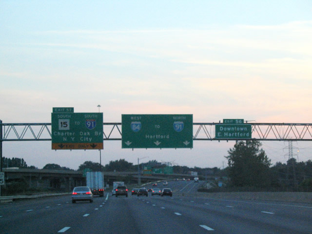
| I-84/U.S. 6 westbound widen to six lanes in anticipation of the split with Route 15 south at Exit 57. Route 15 travels southwest, joining U.S. 5 in the process, across the Connecticut River to meet Interstate 91 in south Hartford. From there Route 15 & U.S. 5 continue west to Berlin Turnpike. 08/09/04 |
|
| All traffic bound for Interstate 91 south to Meriden, New Haven and Interstate 95 should take Route 15 south for is direct connection with the north-south freeway. Interstate 91 ends at Interstate 95 (Connecticut Turnpike) in Downtown New Haven. The Connecticut Turnpike hugs Long Island Sound through such cities as Bridgeport, Norwalk, and Stamford before crossing into New York state at Port Chester. An auxiliary overhead directs Downtown East Hartford motorists west to Exit 56 otherwise. 08/09/04 |
|
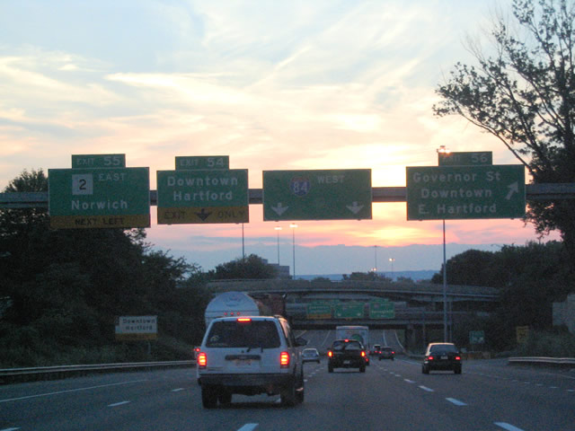
| Continuing westward on I-84/U.S. 6 ahead of the confluence with Route 2 (Exit 55), the Founders Bridge (Exit 54), Governor Street (Exit 56) and U.S. 44 (Connecticut Boulevard). Route 2 travels a lengthy freeway from Norwich (I-395) west to East Hartford and the Founders Bridge. The Founders Bridge stems west from the Route 2 freeway into Downtown Hartford.
The Governor Street off-ramp represents the planned beginning of unconstructed Interstate 284. 08/09/04 |
|
| Exit 56 leaves I-84/U.S. 6 west for Governor Street and Downtown East Hartford. A short freeway stub stems north from the tri-level stack interchange underneath U.S. 44 (Connecticut Boulevard) to its premature end at Governor Street. Interstate 284 was a planned freeway linking East Hartford with Interstate 291 in South Windsor. 08/09/04 |
|
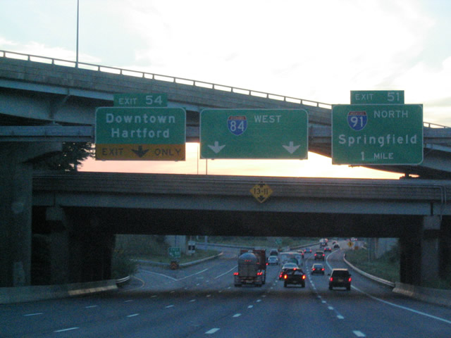
| A pair of left side off-ramps leave I-84/U.S. 6 westbound for Route 2 east (Exit 55) and the Founders Bridge west (Exit 54). Passing overhead is the stub freeway of planned Interstate 284 and its associated ramps. Route 2 travels southeast from both Interstate 84 and the Founders Bridge to Marlborough and Colchester. 08/09/04 |
|
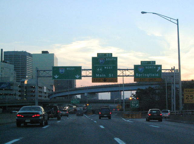
| U.S. 44 merges from Connecticut Boulevard onto the Buckeley Bridge (I-84/U.S. 6) at Exit 53. The trio proceed across the Connecticut River to a multi-level stack interchange (Exit 51) with Interstate 91 at Downtown Hartford. Exit 51 serves Interstate 91 northbound for Bradley International Airport (BDL) and Springfield, Massachusetts. Exit 50 meanwhile comprises a split diamond interchange with Morgan Street, providing the departure point for U.S. 44 west onto Main Street. Motorists bound for Interstate 91 south can depart at Exit 50 and turn around for the Interstate 84 eastbound ramp to I-91 south. 08/09/04 |
|
| I-84/U.S. 6 travel underneath a cut-and-cover tunnel west of the junction with Interstate 91. U.S. 44 travels Morgan Street nearby from Exit 50 to Main Street. 08/09/04 |
|
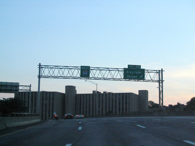
| Interstate 84 encircles the Hartford central business district between Interstate 91 and Bushnell Park. Departing the freeway next is the off-ramp (Exit 48) onto Spring Street south to its intersection with Garden and Asylum Streets. Use Asylum Street eastbound to Ford Street south for the Connecticut State Capitol complex. 08/09/04 |
|
| Interstate 84 passes over Church Street at Exit 48 onto adjacent Spring Street. Ahead are directional ramps for Capitol Avenue and Asylum Street at Bushnell Park. The ramps are situated at the location where planned Interstate 484 would have tied into Interstate 84.
Interstate 484 was to link I-84 with I-91 through the south central business district and Bushnell Park via White Head Highway. The segment between Pulaski Circle and Interstate 84 was never built. 08/09/04 |
|
| I-84/U.S. 6 westbound next meet Sigourney Street at a half diamond interchange (Exit 47), one half mile west of the Asylum Street overpass. Sigourney Street travels north-south between Park Terrace, Capitol Avenue, Asylum Street and U.S. 44 (Albany Avenue). 08/09/04 |
|
| The freeway elevates onto a viaduct over AMTRAK lines between Bushnell Park and Exit 47 to Sigourney Street. A lane drop occurs at Exit 46 for the upcoming tri-level stack interchange to Sisson Avenue and West Boulevard. That interchange represents the southern end of unconstructed Woods River Expressway (Route 189). 08/09/04 |
|
| Exit 44 links I-84/U.S. 6 westbound with Prospect and Oakwood Avenues at the Hartford/West Hartford Town Line. The off-ramp joins the freeway with adjacent Kane Street midway between its intersections with the north-south Prospect and Oakwood Avenues.
The freeway continues west to a directional interchange (Exit 43) with the Trout Brook Connector to Park Road and the West Hartford Center. The Trout Brook Connector was planned as part of the Route 501 freeway connection between I-84 and Farmington Avenue. Only the section between Exit 43 and Park Road was built.1 08/09/04 |
|
| I-84/U.S. 6 turn southward between Trout Brook Drive and Overlook Road between the Trout Brook Connector interchange (Exit 43) and Exit 42. A wye interchange joins the freeway with Trout Brook Drive and Clarendon Avenue near Beechland Park and the Elmwood community of West Hartford. 08/09/04 |
|
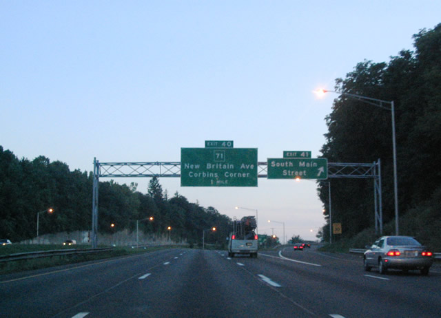
| The freeway turns back westward after the left side off-ramp (Exit 42) to Trout Brook Drive. Next in line for motorists is the diamond interchange (Exit 41) with South Main Street (Route 173).
Route 173 travels 6.17 miles south from Hooker Drive just north of Exit 41 to U.S. 5 & Route 15 in Newington. South Main Street ends at Route 71 (New Britain Avenue) nearby.
Route 71 travels west from Elmwood to meet I-84/U.S. 6 at Exit 40 ahead. 08/09/04 |
|
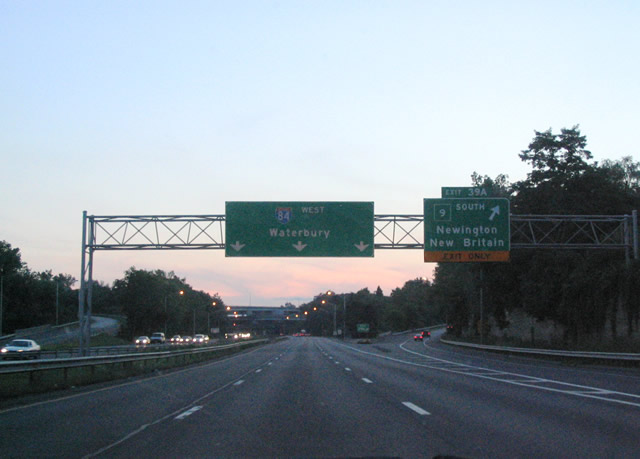
| Westbound at the partially used symmetrical stack interchange with Route 9 (Exit 39) on I-84/U.S. 6. Route 9, designated the Iwo Jima Highway, saw extension northward along the old Route 72 freeway and the 1986-built Shevchenko Expressway into Newington in 1989. The Iwo Jima Highway joined the 1961-completed Route 72 freeway with Interstate 84 on September 30, 1992. The 3.8 mile connection cost $32.5 million and tied into a previously completed four-level stack interchange at Interstate 84. Built as part of the Interstate 291 belt-line, the stack is half utilized with ghost ramps and a stub roadway extending north to Tunxis Road. I-291 was cancelled north of here in 1979 and the existing roadway has sat idle ever since.2
Route 9 otherwise comprises a 40.89 mile freeway between Farmington and Old Saybrook near the mouth of the Connecticut River. The state route serves New Britain and Berlin on the drive to I-91 near Middletown. 08/09/04 |
|
| Westbound at the partially used symmetrical stack interchange with Route 9 (Exit 39) on I-84/U.S. 6. Route 9, designated the Iwo Jima Highway, saw extension northward along the old Route 72 freeway and the 1986-built Shevchenko Expressway into Newington in 1989. The Iwo Jima Highway joined the 1961-completed Route 72 freeway with Interstate 84 on September 30, 1992. The 3.8 mile connection cost $32.5 million and tied into a previously completed four-level -interchange at I-84. Built as part of the Interstate 291 belt-line, the stack is half utilized with ghost ramps and a stub roadway extending north to Tunxis Road. I-291 was cancelled north of here in 1979 and the existing roadway has sat idle ever since.2
Route 9 otherwise comprises a 40.89 mile freeway between Farmington and Old Saybrook near the mouth of the Connecticut River. The state route serves New Britain and Berlin on the drive to I-91 near Middletown. 08/09/04 |
|
| The next in a series of Hartford area unconstructed freeways ties into I-84/U.S. 6 west at Exit 39. Built as a high-powered interchange, Exit 39 to Route 4 (Farmington Avenue) was intended to link I-84/U.S. 6 with the Farmington Bypass. The bypass was to carry Route 4 around the Farmington Town Center to the unconstructed Route 10 freeway. These plans existed in the 1960s and culminated with the construction of the directional interchange at Exit 39 in 1969.3 Route 4 presently ties in with the Exit 39 ramps via Farmington Avenue nearby.
U.S. 6 splits from Interstate 84 at the adjacent wye interchange (Exit 38). 08/09/04 |
|
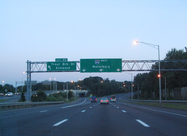
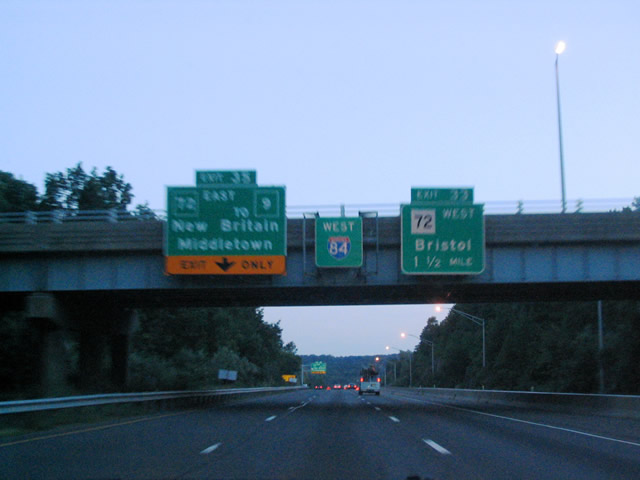
| Interstate 84 turns southward again between the Route 4 connector (Exit 39) and Route 72 (Exits 35 and 33). Route 72 travels a freeway west from Route 9 in New Britain to a merge with Interstate 84 at Plainville. A left-exit departs ahead via Exit 35 for Route 72 east to the Route 9 freeway south to Middletown. Route 72 west splits with Interstate 84 at Exit 33 via the Plainville bypass to Bristol. 08/09/04 |
|
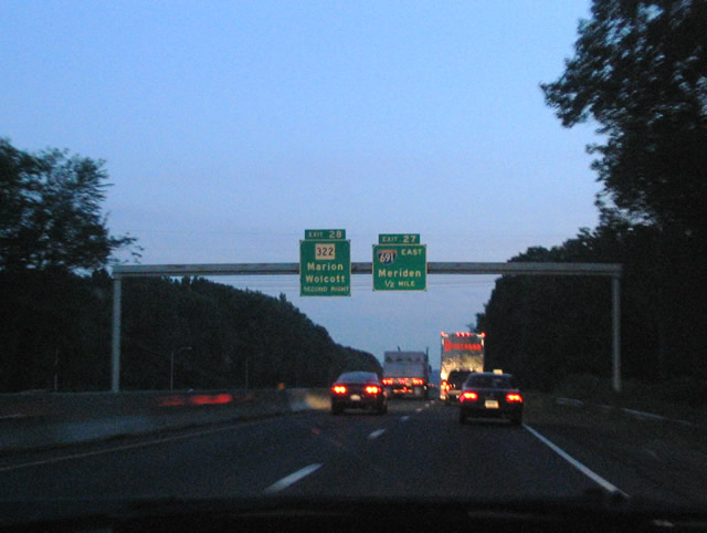
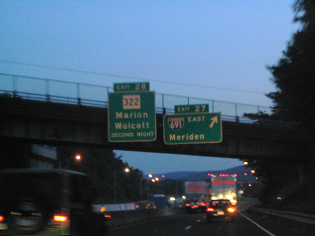
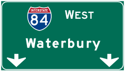
| Approaching the confluence of Exits 28 and 27 with Interstate 691 east and Route 322 (Meriden Waterbury Turnpike). Interstate 691 provides a freeway connection between Interstate 84 and Interstate 91 for Waterbury to Meriden based traffic. Route 322 provides a surface route parallel to I-691 from Exit 4 west to Milldale and Marion. 08/09/04 |
|
| Exit 27 leaves Interstate 84 west for Interstate 691 east at the Burritt Street overpass in the Town of Southington. A tri-level stack interchange joins the two freeways.
Situated within the Exit 27 interchange is a folded diamond interchange (Exit 28) with Route 322 (Meriden Waterbury Turnpike) at the Southington/Cheshire Town line. Route 322 continues west from Interstates 84 and 691 to south of Wolcott before entering Waterbury. 08/09/04 |
Page Updated 04-12-2005.

 West
West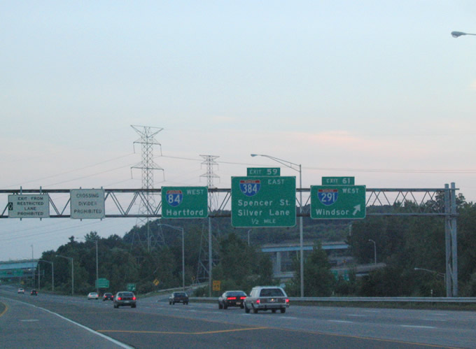

 West
West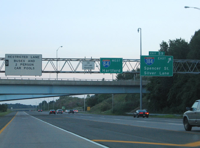


 West
West