|
| The welcome sign stands just beyond mile marker zero in southern Whitley County. I-75 enters Kentucky between Heckler Knob and the Clear Fork river. 01/16/19 |
|
| The Kentucky welcome center lies follows northbound by Sand Rock Ridge. 01/16/19 |
|
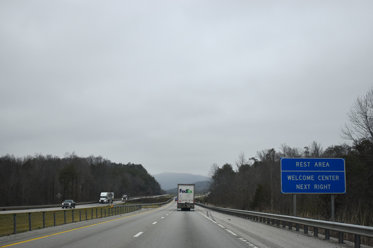
| Interstate 75 crosses the Clear Fork river just ahead of the tourist information center and rest area. 01/16/19 |
|
| Interstate 75 runs 10.34 miles north from the state line to the first exit in Kentucky. 01/16/19 |
|
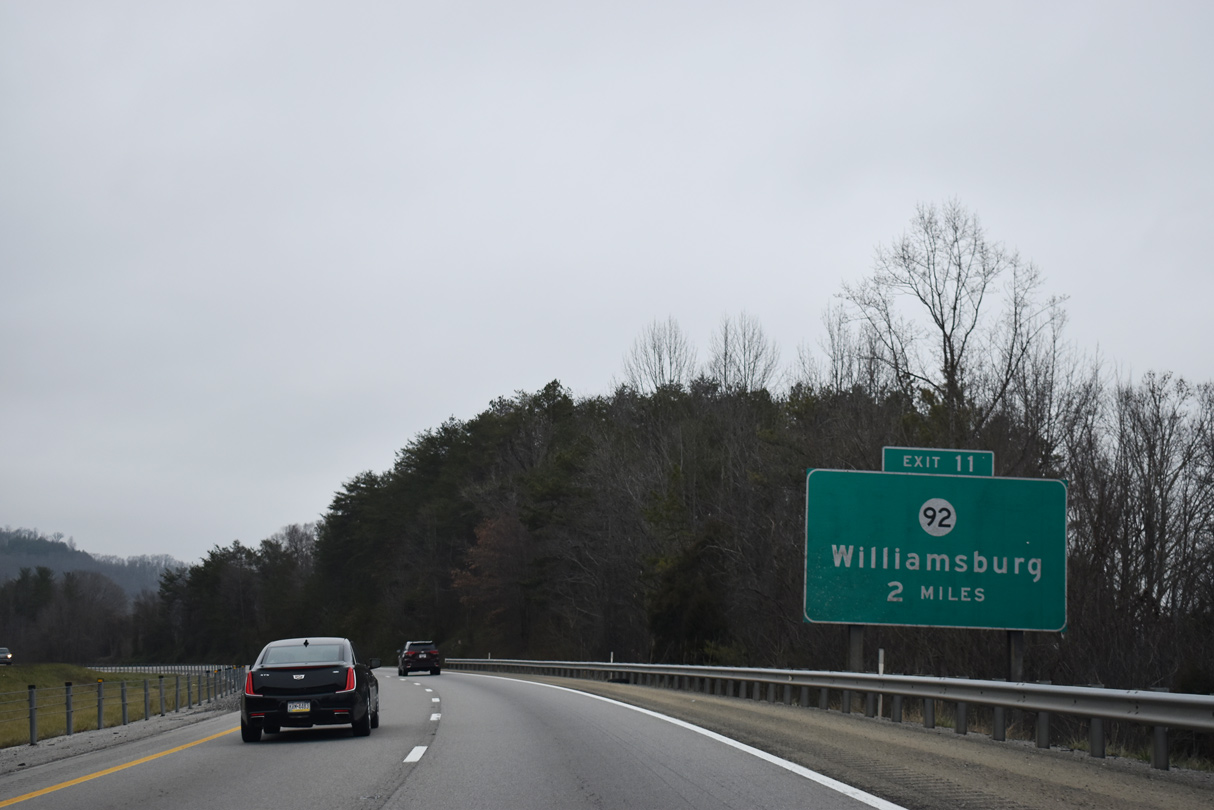
| I-75 parallels U.S. 25W, a CSX Railroad line and the Clear Fork river north from Pleasant View and Emilyn to KY 92 in the city of Williamsburg. 01/16/19 |
|
| Northbound Interstate 75 enters the single point interchange (Exit 11) with KY 92 at Balltown just east of Jellico Mountain. 01/16/19 |
|
| KY 92 runs between Jellico and Bon Jellico Mountain 18.83 miles west from the county seat of Williamsburg to Hollyhill and U.S. 27 at Pine Knot. 01/16/19 |
|
| KY 92 east overlaps with parallel U.S. 25W for 0.61 miles before resuming east along the Cumberland River to Julip and Pineville. 01/16/19 |
|
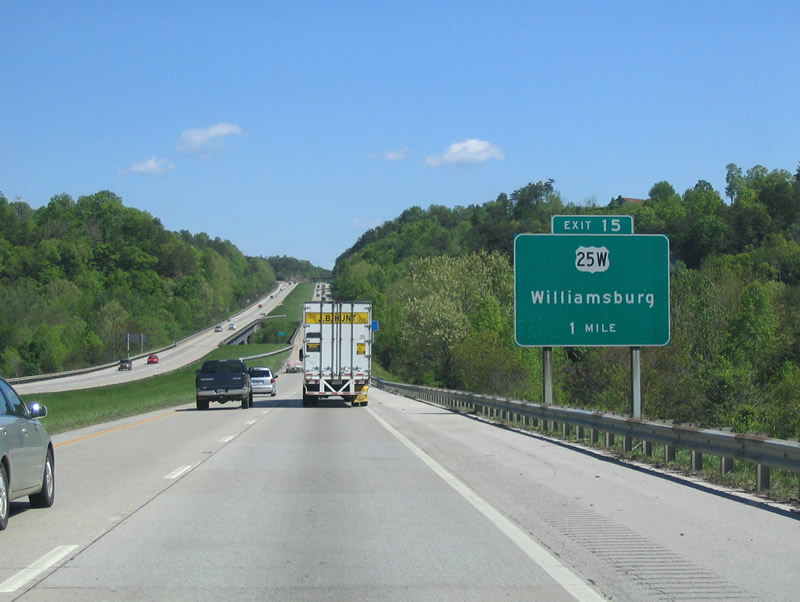
| U.S. 25W runs through Williamsburg before reconvening with Interstate 75 at Exit 15. 05/01/05 |
|
| U.S. 25W runs 5.78 miles northwest from I-75 at Goldbug to KY 90 at Youngs Creek. Cumberland Falls State Resort Park lies along KY 90 west. 05/01/05 |
|
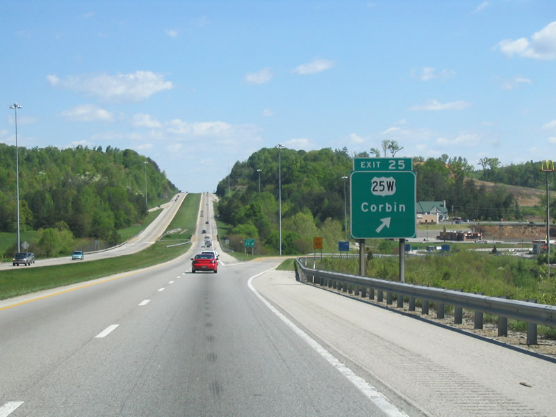
| U.S. 25W turns northeast at KY 90 and continues 7.50 miles to Interstate 75 at Exit 25. 05/01/05, 11/03/11 |
|
| The diamond interchange at Exit 25 joins I-75 with U.S. 25W (Cumberland Falls Highway). U.S. 25W follows 18th Street east to KY 26 and Main Street north through Downtown Corbin. 05/01/05 |
|
| Continuing north, Interstate 75 travels 61 miles to Richmond and 86 miles to Lexington, the state's second largest city. 11/03/11 |
|
| KY 312 (Keavy Road) stems west from U.S. 25W in Corbin across I-75 one mile south of Exit 29. U.S. 25E/25W combine to form U.S. 25 on the north side of Corbin. Connecting I-75 with U.S. 25 was KY 1783, an extension of Cumberland Gap Parkway. KY 1783 was renumbered as an extension of U.S. 25E. 05/01/05 |
|
| KY 770 extends 1.24 miles west from the diamond interchange at Exit 29 to KY 312 near Laurel River Lake. KY 312 extends northwest to Keavy and KY 192 for Daniel Boone National Forest and Laurel River Lake Recreation Area. Corbin is where Colonel Sanders started his restaurant business for what ultimately became Kentucky Fried Chicken (KFC). 05/01/05 |
|
| U.S. 25E (Cumberland Gap Parkway) comprises a four lane highway east from Corbin to the Knox County seat of Barbourville. U.S. 25E continues from the city to Pineville, Pine Mountain State Resort Park and Cumberland Gap National Park. U.S. 25 parallels I-75 north from Corbin to Lily, Fariston and London. 05/01/05 |
|
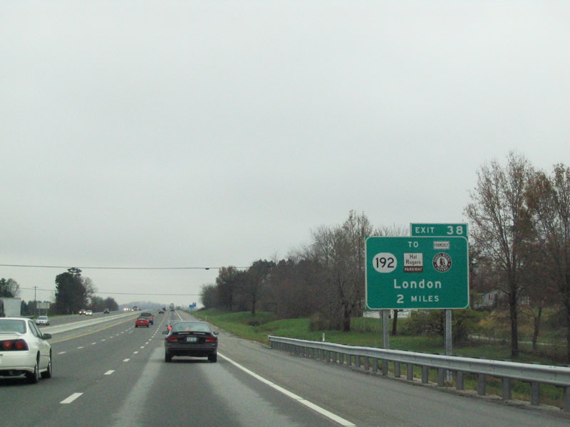
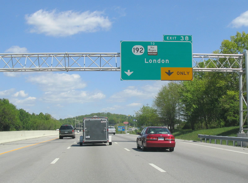
| KY 192 travels northeast from Baldrock and Daniel Boone National Forest to meet Interstate 75 at a diamond interchange (Exit 38). 11/12/04 |
|
| Providing a direct link 3.70 miles east from I-75 to Hal Rogers Parkway, KY 192 constitutes an arterial bypass across south London. 11/12/04 |
|
| Formerly the tolled Daniel Boone Parkway, Hal Rogers Parkway is a two lane expressway east to Manchester and Hazard. Tolls for the parkway ceased on June 1, 2003. U.S. Representative Hal Rogers made appropriations within the federal budget to have the bonds for the parkway paid off. Governor Paul Patton, in an effort to thank Rogers, renamed the parkway after him.1 05/01/05 |
|
| KY 192 is a 40.59 mile long highway west from Hal Rogers Parkway at Londton to KY 80 Business in Somerset. 05/01/05, 11/03/11 |
|
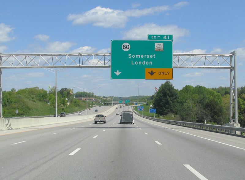
| KY 80 runs west along 4th Street into Downtown London, where it joins U.S. 25 (Main Street) north 1.50 miles to Hal Rogers Parkway. KY 80 extends Hal Rogers Parkway 0.60 miles west to the diamond interchange at Exit 41. 05/01/05 |
|
| I-75 northbound expands to four lanes ahead of Exit 41 for KY 80 (Hal Rogers Parkway) on the north side of London. Hal Rodgers Parkway (KY 9006) encircles London along an at-grade expressway 3.88 miles from U.S. 25/KY 80 to KY 192. 05/01/05 |
|
| Hal Rogers Parkway east connects with KY 30 north from London to the Owsley County seat of Booneville. KY 30 formerly concluded at East Bernstadt along KY 3094. 05/01/05 |
|
| KY 80 (Hal Rogers Parkway) travels west from London to Somerset and Cumberland Parkway. Extending west to the Mississippi River and east to U.S. 23 at Watergap, KY 80 is part of a multi state route with Virginia Route 80. 05/01/05 |
|
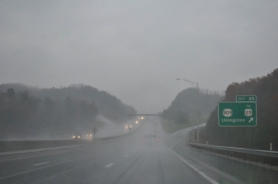
| Interstate 75 leaves London for an eight mile drive into Daniel Boone National Forest at Exit 49. Livingston represents the nearest community at five miles north via U.S. 25. 11/03/11 |
|
| KY 909 constitutes a short connector between the Exit 49 diamond interchange and parallel U.S. 25. A National Forest road ties into the exit from the west. 11/03/11 |
|
| The Rockcastle River separates Laurel and Rockcastle Counties in this rainy northbound scene. 11/03/11 |
|
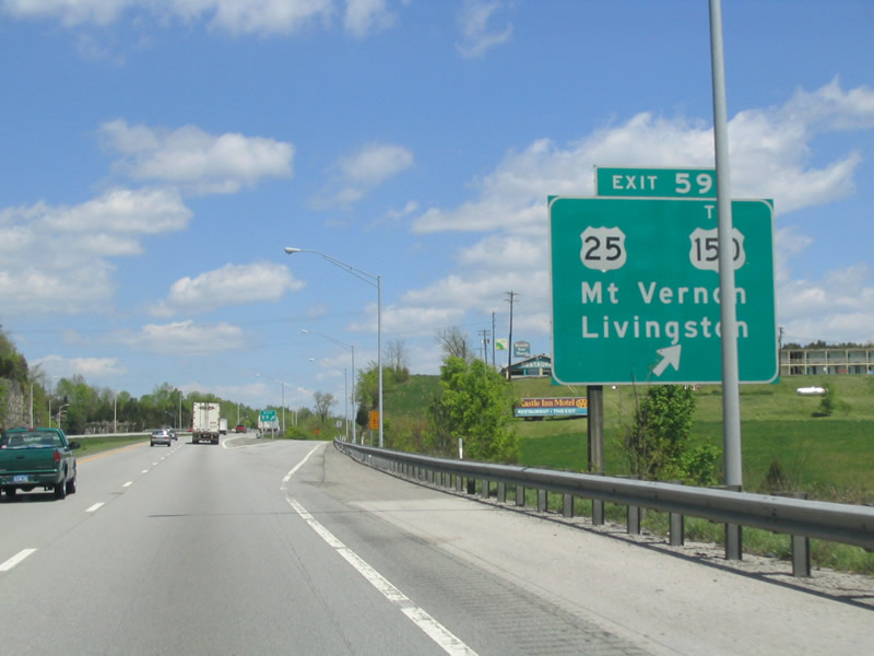
| Drivers exit the National Forest on the approach to Exit 59 and U.S. 25 to U.S. 150 west at Mt. Vernon. 05/01/05 |
|
| A diamond interchange joins I-75 with U.S. 25 at Mt. Vernon. U.S. 25 acts as a business loop through the Rockcastle County seat, meeting the east end of U.S. 150 in downtown. Points of interest for Exit 59 include the William Whitley State Historic Site. 05/01/05 |
|
| U.S. 25 meanders northwest seven miles from Livingston to Interstate 75 at Exit 59. Two miles west of the freeway is the westbound beginning of U.S. 150. U.S. 150 travels 571 miles from Mt. Vernon to Moline, Illinois. 05/01/05 |
|
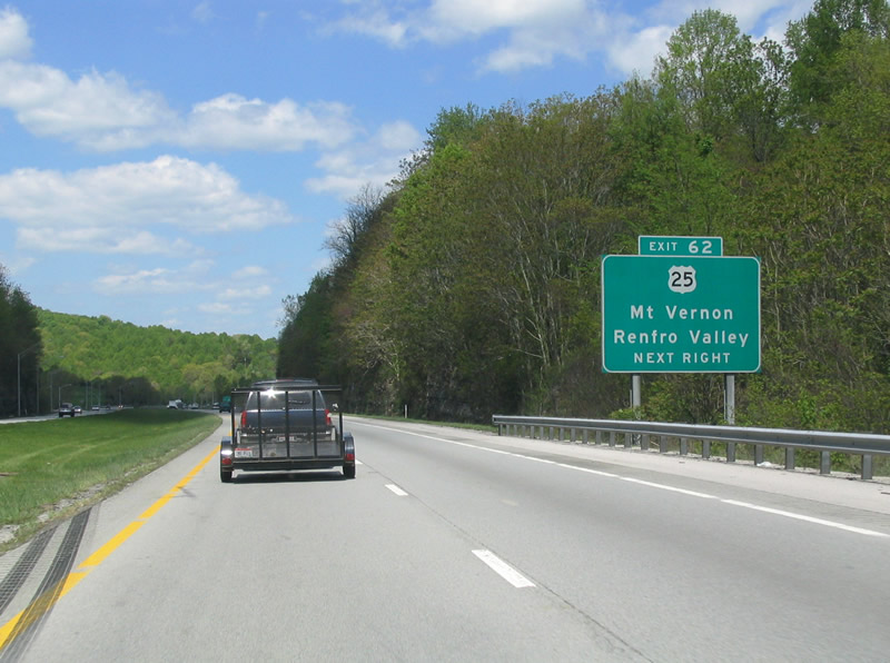
| U.S. 25 follows Richmond Street north from downtown Mt. Vernon to KY 461 on the north side of town. Exit 62 rejoins the US route with Interstate 75 near Lake Linville. 05/01/05 |
|
| Nearing the Exit 62 ramp departure to U.S. 25 north of Mt. Vernon on Interstate 75 north. U.S. 25 stays close to the freeway and enters Renfro Valley nearby. The Kentucky Music Hall of Fame & Museum is a notable point of interest along U.S. 25 south into Mt. Vernon. 05/01/05 |
Page Updated 06-29-2021.

 North
North