|
| Continuing west from the Brazos River and Brazos Country community, IH 10 and U.S. 90 travel five miles to the city of Sealy and 155 miles to San Antonio. 05/27/05 |
|
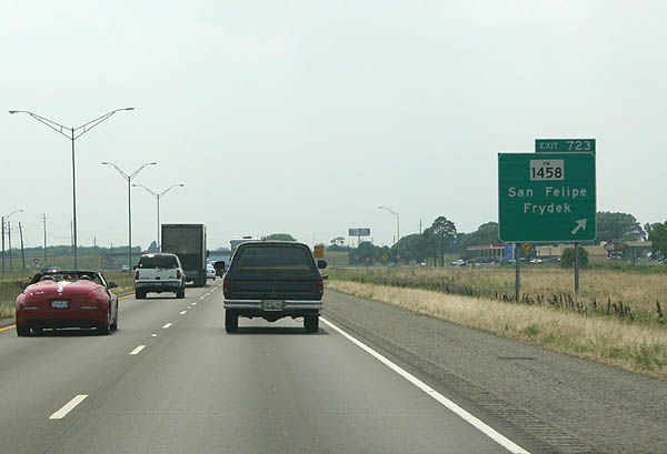
| FM 1458 crosses paths with IH 10/U.S. 90 at the town of San Felipe in a half mile. 05/27/05 |
|
| A 21.09 mile long highway, FM 1458 starts in Pattison and loops west to IH 10, then south to Frydeck and FM 1093 near Wallis. 05/27/05 |
|
| U.S. 90 separates from IH 10 west from Exit 721 into the city of Sealy. U.S. 90 splits from IH 10 at various points between Houston and San Antonio to serve as a business loop through cities and towns, such as Sealy. 05/27/05 |
|
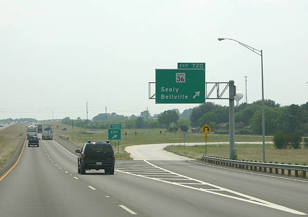
| IH 10 shifts southward to bypass Downtown Sealy, next meeting SH 36 (Meyer Street) at a folded diamond interchange (Exit 720). 05/27/05 |
|
| SH 36 begins in Freeport and travels northwest to Rosenburg and Wallis. North from IH 10 and Sealy, SH 36 continues to Bellville, Brenham and Milano. 05/27/05 |
|
| U.S. 90 rejoins IH 10 at the forthcoming Exit 718 in west Sealy. The two combine westward 23 miles to the Colorado County seat of Columbus. 05/27/05 |
|
| IH 10 and U.S. 90 reach Exit 716 to Pyka Road west of Little Bernard Creek. 05/27/05 |
|
| The diamond interchange with Pyka Road north and Mound Road south serves an SNC Lavalin plant in west Sealy and agricultural areas south of FM 2187. 05/27/05 |
|
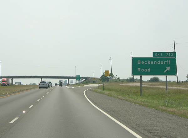
| Beckendorff Road ties into IH 10 at Exit 713 amid ranch land west of Crooked Branch. 05/27/05 |
|
| Heading west into Colorado County, IH 10/U.S. 90 approach Exit 709 with FM 2761 south and Bernardo Road. 05/27/05 |
|
| FM 2761 provides a direct route from IH 10/U.S. 90 southwest 5.87 miles to FM 949 for Eagle Lake. 05/27/05 |
|
| FM 949 angles northwest from FM 2761 to a rural diamond interchange (Exit 704) with IH 10/U.S. 90. 05/27/05 |
|
| Comprising a 26.15 mile long loop, FM 949 leads south from Exit 704 to FM 102 and north to Bernardo Cat Spring and SH 336 south of Bellville. 05/27/05 |
|
| IH 10 rises to around 300 feet above sea level beyond this distance sign posted near Coushatta Creek. Columbus lies eight miles ahead, followed by San Antonio in 134 miles. 05/27/05 |
|
| U.S. 90 splits with IH 10 at Exit 698 for Walnut Street west into the Columbus city center. The freeway stays to the south, spanning the Colorado River ahead of SH 71 south (Exit 696). SH 71 is a major corridor that connects IH 10 north to Austin along a more direct route from Houston than U.S. 290. 05/27/05 |
|
| SH 71 north joins IH 10 west from a diamond interchange west of Ratliff Creek. SH 71 Business extends north along Fannin Street along a 4.22 mile course. SH 71 south continues to SH 35 near Blessing. 05/27/05 |
|
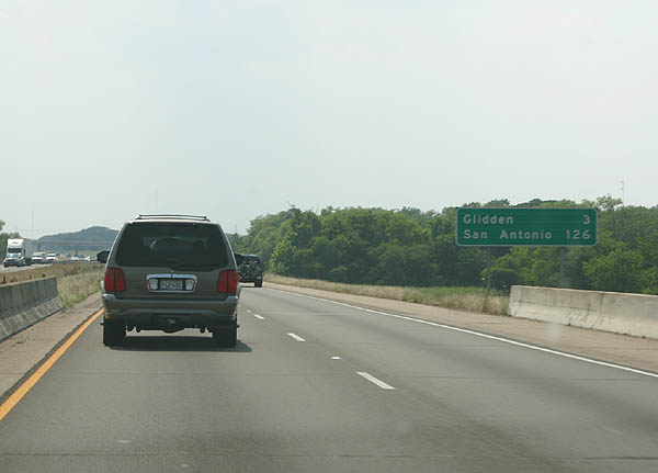
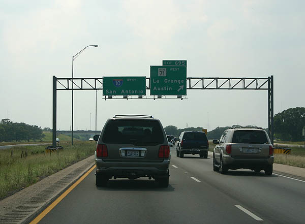
| SH 71 combines with IH 10 two miles west to the Exit 695 by the unincorporated community of Glidden. 05/27/05 |
|
| SH 71 turns north along a bypass of Columbus from a wye interchange (Exit 695) with IH 10. The state highway provides a four lane highway to Austin with expressway bypasses of La Grange, Smithville and Bastrop. 05/27/05 |
|
| FM 2434 stems south from U.S. 90 at Glidden to a diamond interchange (Exit 693) with IH 10. 05/27/05 |
|
| FM 2434 turns west and parallels IH 10 to FM 155 south of Weimar. The FM road measures 12.29 miles in length. 05/27/05 |
|
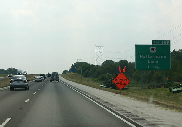
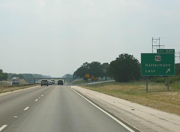
| U.S. 90 converges with the north side of IH 10 midway between Glidden and Borden at Hattermann Lane (Exit 689). 05/27/05 |
|
| The succeeding exit along IH 10 west beyond Exit 689 is at the city of Weimar in seven miles. 05/27/05 |
|
| Entering the diamond interchange (Exit 682) with FM 155 (Eagle Street) at Weimar on IH 10 west. FM 155 joins Weimar with U.S. 71 and La Grange, 16.22 miles north of U.S. 90 (Main Street). The south branch of FM 155 runs 16.06 miles from Main Street to U.S. 90 Alternate near Sheridan. 05/27/05 |
|
| U.S. 90 and IH 10 shift sides on the eight mile drive west from Weimar to the city of Schulenburg. 05/27/05 |
|
| IH 10 crosses into Fayette County and over a Union Pacific Railroad line and the East Navidad River leading into the diamond interchange (Exit 677) with U.S. 90. 05/27/05 |
|
| The next exit joins IH 10 with U.S. 77 (Kessler Avenue) on the north side of Schulenburg. 05/27/05 |
|
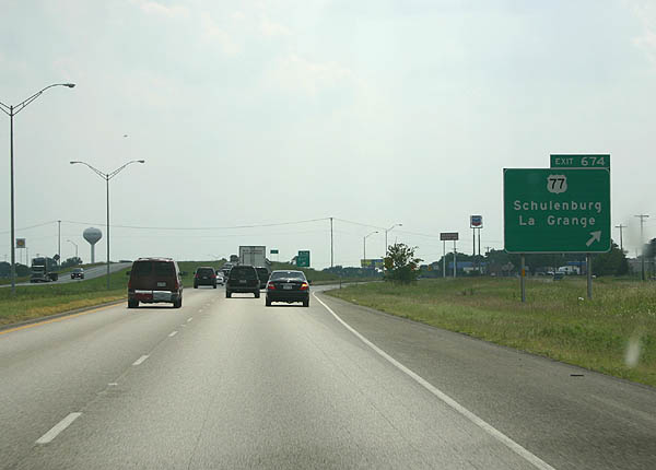
| Exit 674 departs IH 10 westbound for U.S. 77 south to Downtown Schulenburg and 15 miles north to LaGrange. U.S. 77 begins in the Rio Grande Valley and travels through Victoria before reaching IH 10. 05/27/05 |
|
| Continuing 5.4 miles west from Schulenburg, Interstate 10 meets FM 2238 at Exit 668 near the unincorporated community of Engle. FM 2238 dog legs northward 7.24 miles from U.S. 90 to FM 956 at Freyburg. 05/27/05 |
|
| FM 609 (La Grange Street) and SH 95 (Penn Street) tie into Interstate 10 at Exit 661 in the town of Flatonia in one mile. 05/27/05 |
|
| SH 95 starts in Temple and goes south to Yoakum along U.S. 77 Alternate. FM 609 angles 20.09 miles northeast from Flatonia to La Grange. 05/27/05 |
|
| Advancing west into Gonzales County, IH 10 and U.S. 90 meet again at Exit 653 beyond of Peach Creek. U.S. 90 provides the first of two routes to the city of Waelder. 05/27/05 |
|
| U.S. 90 returns to Interstate 10 just ahead of the Caldwell County line. Running along the north side of the freeway, U.S. 90 continues west to merge with U.S. 183 north into the city of Luling. 05/27/05 |
|
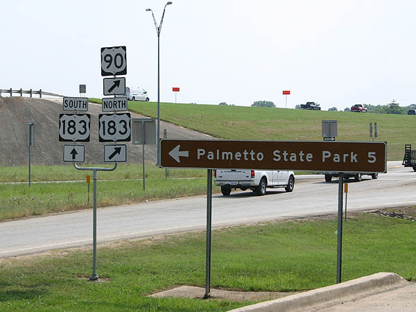
| Bucees and Loves truck stops are located at the diamond interchange (Exit 632) connecting IH 10 with U.S. 183 and adjacent U.S. 90. U.S. 90 & 183 overlap 3.6 miles west to Pierce Street and Magnolia Avenue (SH 80) in Downtown Luling. U.S. 183 south heads to Park Road 11 for Palmetto State Park and Gonzalez. 05/27/05 |
Page Updated 07-16-2019.


 West
West