|
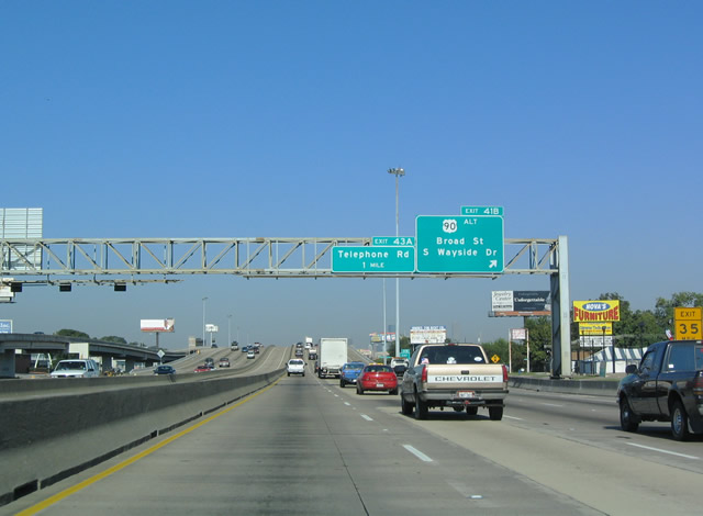
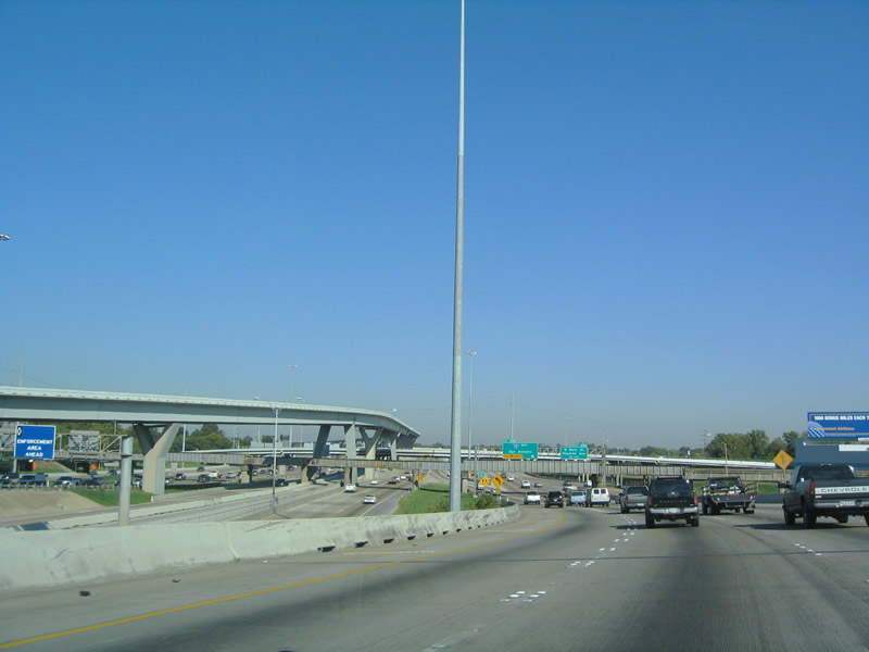
| IH 45 continues north from IH 610 with eight overall lanes plus the tolled Express lane. The Gulf Freeway next meets Broad Street, Griggs Road and U.S. 90 Alternate (Wayside Drive) beyond Brays Bayou. 3.5 years of construction underway from December 2016 builds two flyovers directly connecting IH 45 and IH 610 at the South Loop Interchange. 10/22/03 |
|
| U.S. 90 Alternate follows Old Spanish Trail west from Wayside Drive and Brays Bayou between the MacGregor and Greater OST / South Union neighborhoods. Wayside Drive leads the US highway north to Lawdale/Wayside and 69th Street through Magnolia Park. 10/22/03 |
|
| Telephone Road angles across U.S. 90 Alternate (Old Spanish Trail) at the Gulfgate / Pine Valley at forthcoming Exit 43A. 10/22/03 |
|
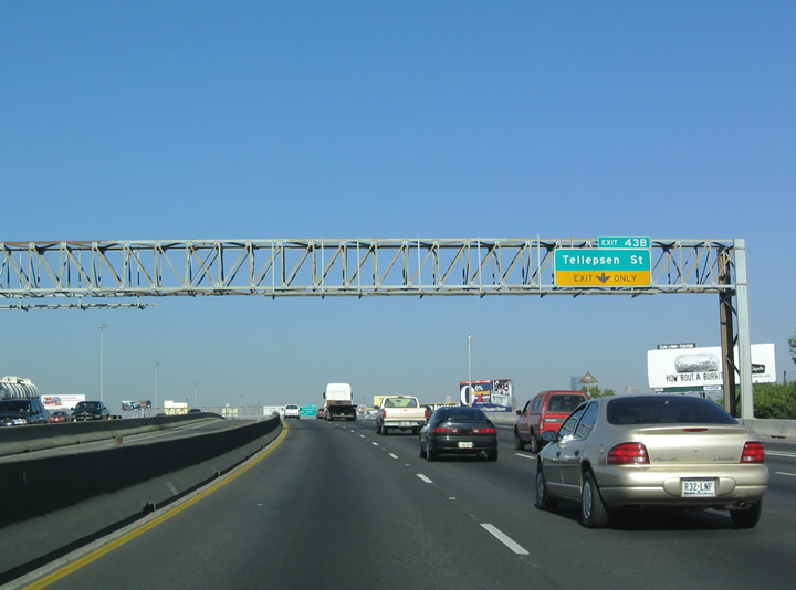
| Telephone Road extends north from IH 45 to the Greater Eastwood neighborhood of Houston. 10/22/03 |
|
| Exit 43B departs just beyond the Telephone Road underpass for Tellepsen Street and industrial areas along the Union Pacific Railroad. 10/22/03 |
|
| Exit 44A departs from the north end of the IH 45 viaduct over Tellepsen Street and the UP Railroad for Elgin Street west and Cullen Boulevard south to the University of Houston and Lockwood Drive north to the Greater Eastwood community. 10/22/03 |
|
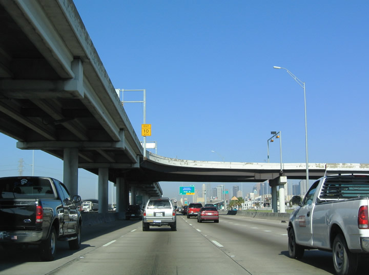
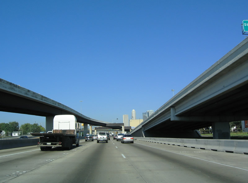
| The Downtown Houston skyline comes into view as IH 45 ascends over the Spur 5 freeway north from U.S. 90 Alternate. The 2.90 mile route of Spur 5 coincides with IH 45 northward to Emancipation Avenue. 10/22/03 |
|
| Exit 45 quickly follows the departure of Exit 44A to Elgin Street and Lockwood Drive onto adjacent SS 5 north to Scott Street. 10/22/03 |
|
| The IH 45 Express lane has a direct exit to Cullen Boulevard to access University of Houston. 10/22/03 |
|
| IH 45 narrows to three northbound lanes at the two lane ramp (Exit 45) for SS 5 to Scott Street. The ensuing stretch of freeway north to Downtown is notoriously congested during peak hours. 10/22/03 |
|
| The elevated lanes of Spur 5 connect IH 45 with Scott Street to Downtown. Spur 5 is part of the planned Alvin Freeway for SH 35. A $387 million project anticipated to start in 2025 will extend the Spur 5 freeway south three miles to Belford Avenue at South Park.1 10/22/03 |
|
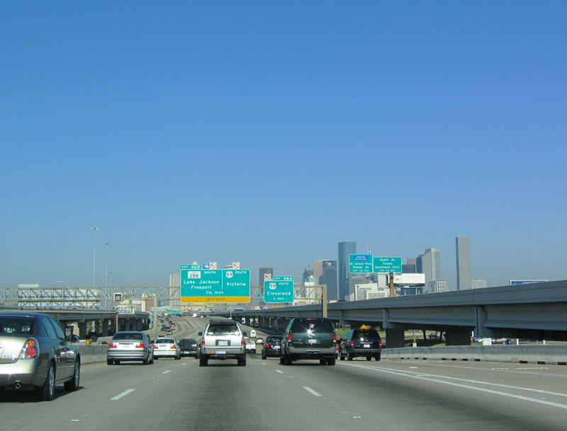
| Exit 46 connects IH 45 northbound with parallel St. Joseph Parkway and the north end of SS 5 at Emancipation Avenue and Pease Street for Downtown Houston. The elevated systems interchange (Exits 46A/B) with IH 69 and U.S. 59 follows. 10/22/03 |
|
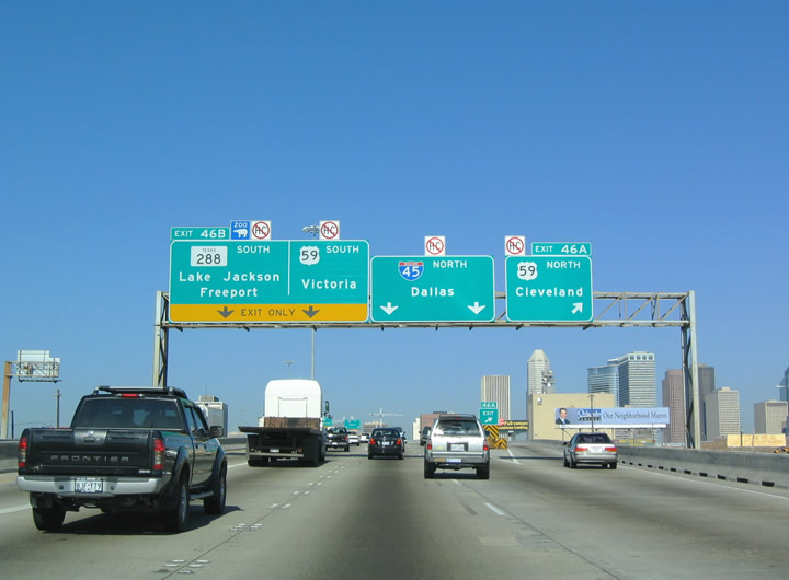
| Left Exit 46B joins IH 45 north with both IH 69/U.S. 59 south to Sugarland and Rosenberg and the SH 288 freeway south to Pearland, Manvel and Iowa Colony. 10/22/03 |
|
| The flyover taking SS 5 south from Jefferson Street spans IH 45. 10/22/03 |
|
| The U.S. 59/IH 45 interchange opened in 1974. The left exit for IH 69/U.S. 59 south permanently closed on January 25, 2019 for replacement with a flyover ramp departing from the outside lanes of IH 45 northbound.2 10/22/03 |
|
| SH 288 originates from SH 36 in the coastal city of Freeport, 59.87 miles to the south. The commuter freeway branches south from IH 69/U.S. 59 to the MacGregor and Central Southwest communities in Houston to Beltway 8 at Pearland. Tolled express lanes were built along the South Freeway in 2019. 10/22/03 |
|
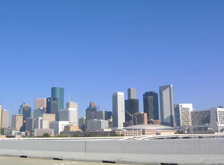
| High rises in Downtown Houston rise beyond the Toyota Center (home of the NBA Houston Rockets) to the north of the exchange of IH 45/69. 10/22/03 |
|
| Built within a narrow right of way, the Pierce Elevated opened in 196 . Due to construction delays and increasing costs, only ½ block of right of way next to Pierce Street was acquired, which today leads to a bottleneck at all hours on IH 45. 10/22/03 |
|
| The North Houston Highway Improvement Project will demolish the Pierce Elevated along the west side of Downtown Houston and relocate IH 45 onto a side by side alignment with IH 69/U.S. 59 to the east. 10/22/03 |
|
| Advance signage for Exits 47A, Allen Parkway, and 47B, Houston Avenue and Memorial Drive. IH 45 encircles the northwestern city of the central business district through a complicated interchange with Allen Parkway and Memorial Drive, controlled access roads paralleling Buffalo Bayou from the west. 10/22/03 |
|
| IH 45 remains elevated as it approaches Memorial Drive and Allen Parkway. Memorial Drive extends west from Downtown to Memorial Park and IH 610. Houston Avenue stems north to the Greater Heights neighborhood. 10/22/03 |
|
| IH 45 dips under Dallas Street, while elevated c/d roadways pass overhead. Northbound, the adjacent flyover ramp is an entrance from Pierce Street and Brazos Street, while the southbound flyover is an exit to Pierce and Jefferson Streets. The elevated ramps were added in 1962, while the Dallas Street overpass dates back to 1955. 10/22/03 |
|
| Ascending from below Dallas Street, Exits 47A/B depart simultaneously from IH 45 northbound for Allen Parkway on the left and Memorial Drive on the right. Exit 47B joins with an exit from the northbound collector distributor road. 10/22/03 |
|
| IH 45 rises onto a bridge system spanning Allen Parkway, Walker Street and Buffalo Bayou beside side Sam Houston Park and several Downtown skyscrapers. 10/22/03 |
|
| Continuing through the interchange complex with Allen Parkway on IH 45 north. Allen Parkway is a urban expressway with just one signalized intersection west from Dallas / Lamar Streets in Downtown to Kirby Drive. 10/22/03 |
|
| IH 45 (Gulf Freeway) northbound passes over the ramp for Houston Avenue and Memorial Drive and below the flyover joining southbound with McKinney Street beyond Buffalo Bayou. 10/22/03 |
|
| Passing the Downtown Aquarium, IH 45 approaches a directional T interchange (Exits 48A/B) with IH 10. IH 10 west toward San Antonio is a left exit. 10/22/03 |
|
| Exit 48A departs from the IH 45 viaduct to IH 10 east to the Greater Fift Ward, Denver Harbor / Port Houston and the Pleasantville Area of central Houston. 10/22/03 |
|
| Looking back toward Downtown Houston from the elevated lanes of IH 45 over Dart Street. 10/22/03 |
|
| IH 45 turns northward alongside IH 10 and White Oak Bayou to a three-wye interchange at Houston and Quitman Streets. The IH 10 HOV lane into Downtown is elevated, while IH 10 runs between both directions of IH 45 10/22/03 |
|
| Continuing north below a Union Pacific Railroad bridge, Left Exit 48B slips onto parallel IH 10 west to the Washington Ave Coalition / Memorial Park and Spring Branch East neighborhoods and the suburb of Katy. 10/22/03 |
|
| IH 45 north and the elevated IH 10 HOV lane at Hogan Street. 10/22/03 |
|
| Leaving IH 10 behind, IH 45 proceeds north following Little White Oak Bayou. This section of freeway opened in 1962, and was renovated in 1982. 10/22/03 |
|
| IH 45 expands with a reversible Express Lane running between the general travel lanes north from IH 10. 10/22/03 |
|
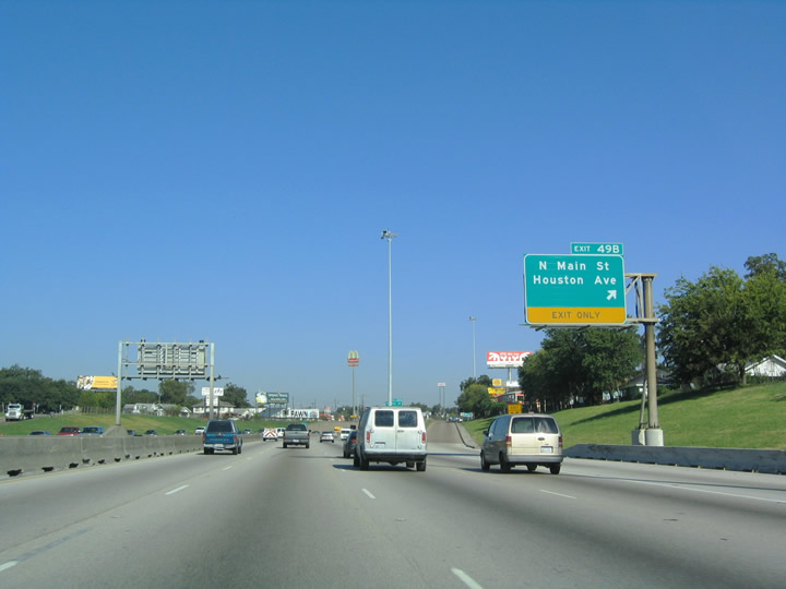
| Houston Avenue meets IH 45 again at Exit 49B with North Main Street. 10/22/03 |
|
| Exit 49B leaves the freeway northbound at the Near Northside neighborhood. IH 45 is below grade north of IH 10 and remains so until IH 610, reflecting the Kyser designs which were influenced heavily by California. 10/22/03 |
|
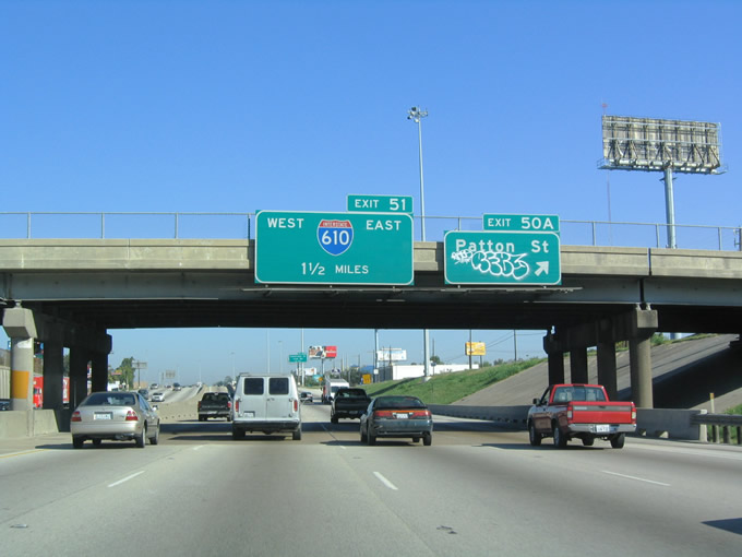
| Advancing north, IH 45 next meets Patton Street at Exit 50A. 10/22/03 |
|
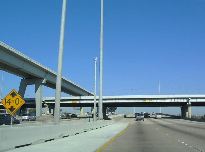
| Exit 50A parts ways for the North Freeway Service Road ahead of Patton Street to the Greater Heights and Near Northside neighborhoods. The four level interchange with IH 610 lies 1.50 miles ahead. 10/22/03 |
|
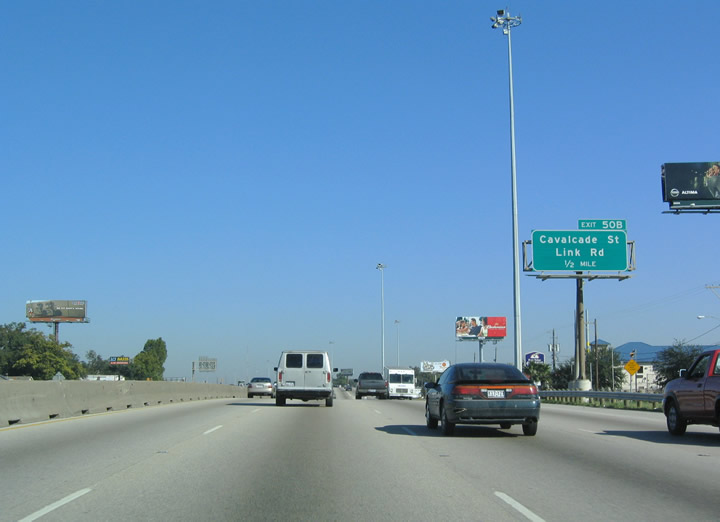
| Exit 50B constitutes a diamond interchange with the IH 45 service roads at Cavalcade Street. Link Road parallels to the north. 10/22/03 |
|
| IH 610 connects IH 45 with the nearby Hardy Toll Road. Paralleling to the east, the toll road provides an alternate route north to George Bush Intercontinental Airport (IAH). 10/22/03 |
|
| Exit 50B leaves IH 45 north for Cavalcade Street and Link Road just south of the systems interchange with IH 610. 10/22/03 |
|
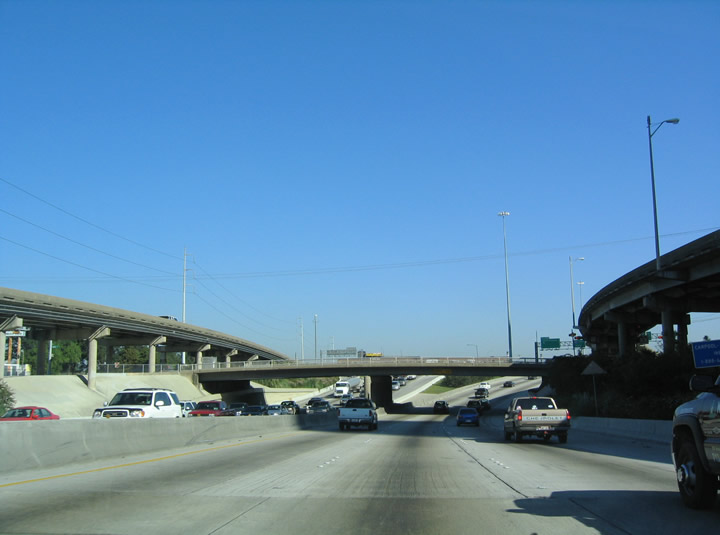
| The freeway rises from below grade and crosses over Link Road on the approach to Exit 51 with Interstate 610. 10/22/03 |
|
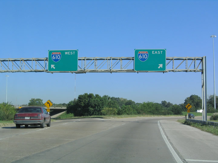
| North Loop 610 comprises a commuter freeway west to the Central Northwest and Lazy Brook / Timbergrove communities and east to the Trinity / Houston Gardens and Kashmere Gardens neighborhoods of Houston among others. 10/22/03 |
|
| IH 610 west links with U.S. 290 to Jersey Village and the northwest Harris County suburbs. The North Loop Freeway connects with IH 69/U.S. 59 north to Humble and U.S. 90 (Crosby Freeway) east to Dayton. 10/22/03 |
|
| Just north of IH 610, the freeway right of way narrows. IH 45 is congested along this stretch of the North Freeway quite often. 06/19/05 |
|
| Exit 52B departs for Crosstimbers Street at a commercialized area along the west side of the Northside / Northline neighborhood. 06/19/05 |
|
| Airline Drive parallels IH 45 north through the Independence Heights community to meet the freeway at Exit 53. 06/19/05 |
|
| Exit 54 immediately follows the Airline Drive underpass along IH 45 north for the service road to Tidwell Road. 06/19/05 |
|
| Advancing northward, a number of billboards and businesses cluster against the freeway at Exit 55A for Parker Road and Yale Street. Parker Street is an arterial leading west to SS 261 (Shepherd Drive) at the Acres Home neighborhood and east into the Eastex - Jensen Area. 06/19/05 |
|
| Parker Street is an arterial leading west from Exit 55A to SS 261 (Shepherd Drive) at the Acres Home neighborhood and east into the Eastex - Jensen Area. 06/19/05 |
|
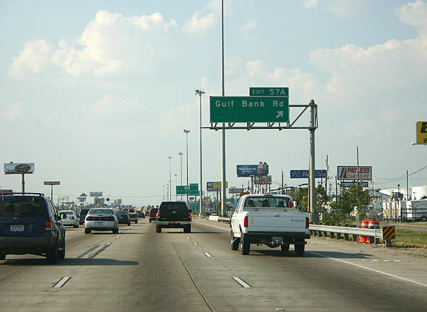
| The North Freeway proceeds north with eight general travel lanes an a reversible Express lane over Little York Road to Exit 57A for Gulf Bank Road. Prior to 2015, Exit 57A was designated Exit 56A and signed for Canino Road. 06/19/05 |
|
| The previous ramp (Exit 57A) for Gulf Bank Road was removed during 2014 construction of the flyover taking Spur 261 (Shepherd Drive) north onto IH 45 from the Acres Home neighborhood of north Houston. 06/19/05 |
|
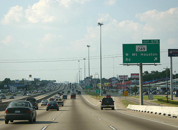
| SH 249 (Mt. Houston Road) stems west along the Houston city line at Hidden Valley to Tomball Parkway from upcoming Exit 57B. 06/19/05 |
|
| SH 249 comprises a 26.62 mile long highway from IH 45 and north Houston to Tomball and FM 149 and FM 1774. The majority of the route beyond Beltway 8 is a limited access highway along Tomball Parkway. Previous proposals outlined extending the SH 249 freeway southeast to IH 45 as a toll road. 06/19/05 |
|
| Continuing north through the Greater Greenspoint community, IH 45 next meets West Road at Exit 59. 06/19/05 |
|
| Exit 59 parts ways from IH 45 north for West Road to Greater Greenspoint in Houston and Veterans Memorial Drive in unincorporated Harris County. 06/19/05 |
|
| 0.75 miles south of Exit 60A for FM 525 (Aldine Bender Road) east and Fallbrook Road west. 06/19/05 |
|
| The systems interchange with Sam Houston Tollway / Beltway 8 lies just beyond FM 525 (Aldine Bender Road) along IH 45 northbound. 06/19/05 |
|
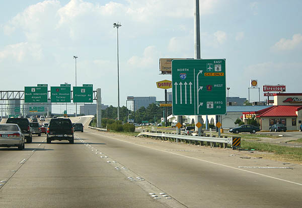
| Beltway 8 travels two miles east from Exit 60D to the Hardy Toll Road for George Bush Intercontinental Airport (IAH). 06/19/05 |
|
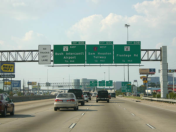
| Exit 60A departs IH 45 north for FM 525 (Aldine Bender Road) east to the IAH / Airport Area of northeast Houston and Fallbrook Road west to an industrial park. Passing overhead are flyovers joining the IH 45 Express lanes with the Sam Houston Tollway. 06/19/05 |
|
| Three successive off-ramps (Exits 60B/C/D) depart over the span of a half mile for Beltway 8, the Sam Houston Tollway frontage road system, and the toll road mainline. 06/19/05 |
|
| The IH 45 northbound mainline proceeds through the multi level exchange with the Sam Houston Tollway by Greenspoint Mall. The ensuing frontage road exit leads to the retail complex and Beltway 8. 06/19/05 |
|
| Exit 60B leaves IH 45 north for the North Freeway Service Road ahead of Beltway 8 and Greenspoint Mall. 06/19/05 |
|
| A high speed flyover (Exit 60C) connects IH 45 north with the Sam Houston Tollway west toward the Willowbrook community of Houston and Jersey Village. 06/19/05 |
|
| Sam Houston Parkway represents the toll freeway portion of the beltway east from IH 45 (Exit 60D) to IAH Airport, IH 69/U.S. 59 and Mesa Drive. 06/19/05 |
Page Updated 07-13-2019.

 North
North