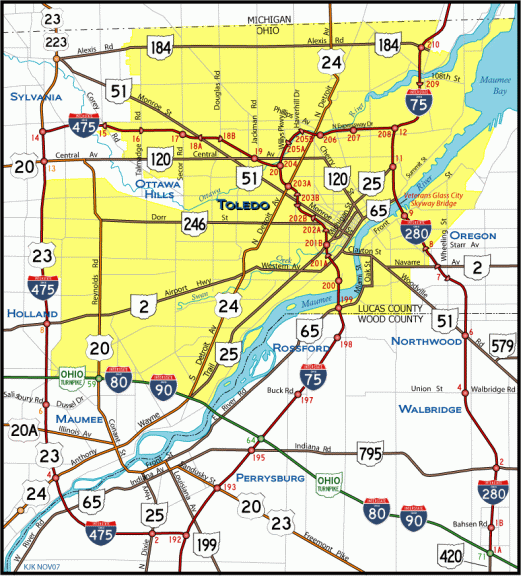

Interstate 280 is a freeway loop joining I-75 and areas east of Downtown Toledo with the cities of Oregon and Northwood south of the Maumee River. The south end of the 12.38 mile long route connects with the Ohio Turnpike and SR 420 in Lake Township.
Interstate 280 Ohio Guides
A signature span, the Veterans' Glass City Skyway, spans the Maumee River from the Bush Street Historic District to Thomas Edison Park at East Toledo. Plans for the bridge originated in the mid 1980s, when the Toledo Metropolitan Area Council of Governments identified an upgrade for the I-280 Maumee River crossing as a top priority.1 Costing $237 million to build, ground breaking for the Skyway took place in May 2001 while associated work underway expanded Interstate 280. Formal construction on the cable-stay bridge commenced in 2002.2
Trajedy struck the construction site for the Skyway on February 16, 2004, when a crane collapsed, killing four ironworkers. Work ceased for eight months, followed by another delay of eight months after a crane accident took place on the day construction resumed. I-280 was subsequently closed to traffic for over 13 months in 2005/06 while the North Toledo approach viaduct was constructed. Prior to the crane collapse, the contractor and the Ohio Department of Transportation (ODOT) agreed to an accelerated construction date. The span was not completed until nearly 22 months from that date, and eight months beyond the original contract completion date.2
The Veterans' Glass City Skyway was finally dedicated on June 23, 2007, with a four mile race/walk and a motorized parade of veteran's groups and labor organizations following the ceremony. Crossing the Maumee River with 120 feet of vertical clearance, the span opened to vehicular traffic the following morning. Including the bridge approaches, the Skyway is 8,800 feet long, with a main span length of 1,225 feet. Supporting two cable stays and decorated with glass panels, the single pylon for the bridge tops out at 403 feet 3 inches.4
The Craig Memorial Bridge, the previous drawbridge for I-280 across the Maumee River, was repurposed as part of State Route 65 between Front and Summit Streets. Interchanges with those streets were replaced with intersections during work in 2008/09.3 Vacated land along the previous alignment of I-280 was converted into a park.2
Veterans' Glass City Skyway was one of the two most popular entries from a bridge naming contest held in 2001 by the Maumee River Crossing Task Force, a volunteer group of local leaders and citizens. Veteran's Memorial Bridge was the other entry, and the two names were combined by the Ohio legislature in December 2004.1
- "Skyway set to bridge Toledo - Pedestrians have $237M signature span to themselves today." Blade, The (Toledo, OH), June 23, 2007.
- "City's new Skyway hailed as 'civic cathedral' in sky - Dedication precedes opening of Toledo's bridge to future." Blade, The (Toledo, OH), June 24, 2007.
- "Drivers make 1st journeys onto Skyway - Early risers vie to be inaugural motorists across signature span." Blade, The (Toledo, OH), June 25, 2007.
- "Quantities of materials and other facts associated - with the Veterans' Glass City Skyway:" Blade, The (Toledo, OH), June 17, 2007.
Connect with:
Interstate 75
Interstate 80
Interstate 90
State Route 51
Page Updated 08-07-2021.
