|
| Confirming marker posted north between Interstate 12 and the overpass for LA 1040 (Old Baton Rouge Highway). 05/09/15 |
|
| U.S. 190 constitutes a commercialized arterial across west Hammond to forthcoming Exit 31. 05/09/15 |
|
| East of U.S. 51, U.S. 190 partitions into a couple of Morris Avenue and Thomas Street through Downtown Hammond. 05/09/15 |
|
| U.S. 190 travels 4.7 miles west from the folded diamond interchange at Exit 31 to LA 43 in the town of Albany. 05/09/15 |
|
| Interstate 55 ascends over the Canadian National Railroad line a half mile ahead of Exit 32 to LA 3234 (University Avenue) and Wardline Road west of Hammond. 05/09/15 |
|
| 2.78 miles long, LA 3234 follows University Avenue eastward from I-55 to Southeastern Louisiana University and LA 1065 (Cherry Street). 05/09/15 |
|
| Northbound I-55 crosses the Yellow Water River at this reassurance marker north of U.S. 190. Rogers Road is the east side frontage road. 05/09/15 |
|
| A diamond interchange at Exit 32 joins Interstate 55 with LA 3234 (University Avenue) east and Wardline Road west. 05/09/15 |
|
| Wardline Road extends 2.76 miles west from University Avenue and Exit 32 to Durbin Road northwest of Baptist. 05/09/15 |
|
| Northbound Interstate 55 confirming marker posted at milepost 33. 11/20/08 |
|
| The first reference of the Mississippi capital city along Interstate 55 north references Jackson at 122 miles away. 11/20/08 |
|
| LA 442 meets Interstate 55 at a diamond interchange (Exit 36) near the village of Tickfaw. 11/20/08 |
|
| Interstate 55 bypasses Natalbany to the west, from LA 1064 northward, to LA 442 at Tickfaw. 11/20/08 |
|
| Exit 36 leaves Interstate 55 northbound just west of Tickfaw. Mostly a rural highway, LA 442 runs 23.10 miles between LA 63 and LA 40. 11/20/08 |
|
| Interstate 55 bends northwesterly toward Independence and LA 40 on a parallel course to U.S. 51. 11/20/08 |
|
| Advancing toward the town of Independence and the diamond interchange (Exit 41) with LA 40. LA 1063 (Robertson Road) crosses the freeway one mile ahead of LA 40. 10/24/03, 11/20/08 |
|
| 2003 sign replacements added half mile entries for Interstate 55 interchanges in Tangipahoa Parish. 11/20/08 |
|
| LA 40 begins 5.5 miles west at LA 43. East of Independence, the state highway continues to Loranger and Folsom en route to LA 41 at Bush. LA 40 is 53.28 miles in length. 11/20/08 |
|
| Pine forest lines the bulk of Interstate 55 from Independence west of the settlements of Millards and Velma along U.S. 51. 11/20/08 |
|
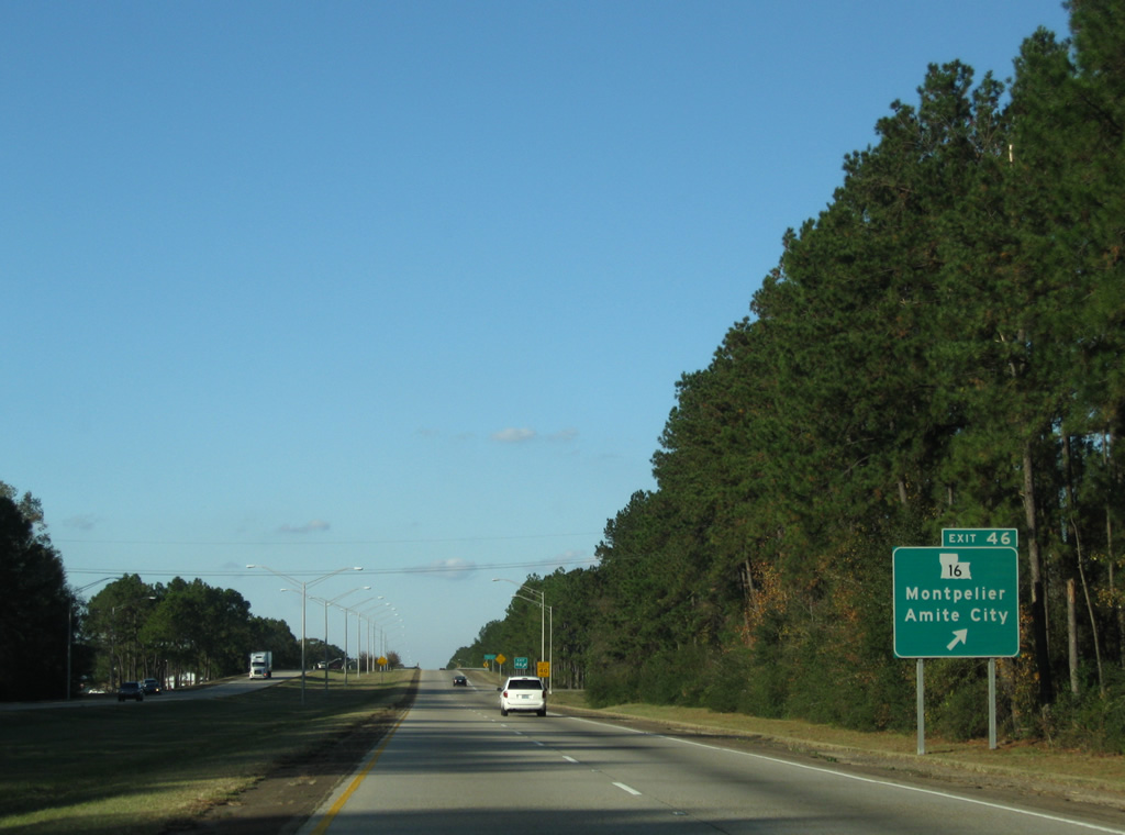
| Just west of Amite City is the diamond interchange (Exit 46) with LA 16 (Oak Street). 11/20/08 |
|
| LA 16 loops 110.7 miles north of Lakes Maurepas and Pontchartrain through the communities of Port Vincent, Denham Springs, Watson, Montpelier, Amite, Holton, Franklinton and Sun. 11/20/08 |
|
| Sign changes made in 2003 renumbered the off-ramp to LA 16 from Exit 47 to 46. 10/24/03 |
|
| LA 16 intersects U.S. 51 (Central Avenue) 1.3 miles east of Interstate 55. Montpelier is an eight mile drive to the west in St. Helena Parish. 11/20/08 |
|
| Continuing north along Interstate 55 from western Amite to the Roseland area. Jackson is 107 miles away. 11/20/08 |
|
| The initial sign for Exit 50 to LA 1048 stood by the Pikes Road over crossing. This sign was removed in 2003 and not replaced. It was actually posted 1.25 miles south of the diamond interchange. 10/24/03 |
|
| LA 1048 is a short highway comprising 4.97 miles between LA 1047 in rural St. Helena Parish and U.S. 51 at Arcola. 11/20/08 |
|
| Exit 50 parts ways with Interstate 55 north for LA 1048. The city of Roseland lies just south of the U.S. 51 intersections with LA 1048 west and LA 10 east nearby. 11/20/08 |
|
| LA 1048 provides an alternate route with LA 1047 and LA 441 for LA 10, which overlaps along U.S. 51 north to Fluker before turning west to Greensburg. 11/20/08 |
|
| Traffic counts remain rather low along Interstate 55 between Amite and Tangipahoa, ranging from 18,081 to 13,972 vehicles per day per 2010 counts by LADOTD. 11/20/08 |
|
| Jackson, Mississippi is another 103 miles to the north as Interstate 55 continues to within two miles of LA 10 (Exit 53). 11/20/08 |
|
| Interstate 55 northbound, one mile south of Exit 53 and LA 10. LA 10 meets I-55 nine miles east of the Saint Helena Parish seat of Greensburg and 1.25 miles west of Fluker and U.S. 51. 10/24/03, 11/20/08 |
|
| LA 10 nearly travels the width of the state beginning at U.S. 171 (Pickering) and ending at the Mississippi State line (Pearl River). The state highway is 250.03 miles long. 11/20/08 |
|
| East of Roseland, LA 10 continues to the Washington Parish seat of Franklinton and Bogalusa before exiting the state to become Mississippi Highway 26. MS 26 is the first crossing of the Pearl River north of I-59/U.S. 11 and south of the state line. MS 26 comprises a lengthy route east to Poplarville, Wiggins and Lucedale. 10/24/03, 11/20/08 |
|
| Confirming marker posted north of the LA 10 entrance ramp. 10/24/03 |
|
| The distance sign posted 100 miles south of Jackson stands at the former Tangipahoa northbound rest area. 11/20/08 |
|
| Just north of Cline Branch, I-55 advances one mile to Exit 47 with LA 440 near the city of Tangipahoa. 10/24/03, 11/20/08 |
|
| LA 440 meets Interstate 55, 1.2 miles west of Tangipahoa and U.S. 51. 11/20/08 |
|
| A 27.7 mile highway, LA 440 joins Tangipahoa and Interstate 55 with LA 441 in St. Helena Parish to the west and LA 10 at Richardson, just west of Franklinton, to the east. 11/20/08 |
|
| Interstate 55 crosses Beaver and Black Creeks ahead of the LA 1050 overpass beyond this shield assembly. 11/20/08 |
|
| LA 38 is the last Pelican State exit in three miles. Jackson is 97 miles out. 11/20/08 |
|
| Northbound travelers enter the city limits of Kentwood ahead of Button Creek and the LA 1049 underpass. Exit 61 follows with LA 38 (Avenue G). 11/20/08 |
|
| LA 38 constitutes 48.6 miles between Darlington (LA 10), Chipola, Mount Hermon, Clifton and LA 430 in Washington Parish. 11/20/08 |
|
| Interstate 55 northbound at the diamond interchange (Exit 61) with A 38 (Avenue G) in Kentwood. LA 38 meanders ten miles west to Easleyville and LA 43. Liverpool is one mile south via LA 43. 10/24/03, 11/20/08 |
|
| The final shield of Interstate 55 north in Louisiana precedes the crossing of Cool Creek in the city of Kentwood. 11/20/08 |
|
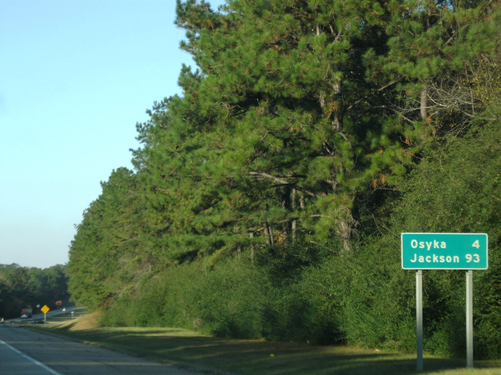
| Interstate 55 exits Louisiana near the town of Osyka, Mississippi and continues 93 miles north to Jackson. 11/20/08 |
|
| A closed weigh station follows the bridge over Terrys Creek at milepost 64. 11/20/08 |
|
| Crossing the Mississippi State line into Pike County along Interstate 55 north. The first Magnolia State exit departs in a half mile for MS 584 to Osyka. 11/20/08 |
Page Updated 06-30-2023.


 North
North