|
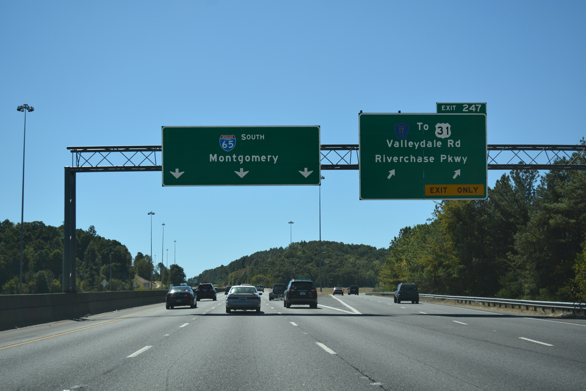
| One half mile north of the folded diamond interchange (Exit 247) with Shelby County 17 (Valleydale Road) on Interstate 65 south. Valleydale Road is a suburban route leading east from U.S. 31 (Montgomery Highway) through Little Valley to Rutherford Lakes nearby. 10/09/16 |
|
| Exit 247 comprises a two lane off-ramp from Interstate 65 south to Valleydale Road. CR 17 stretches from Pelham along New Hope Mountain to U.S. 280 in east Hoover. Westward the county road meets Riverchase Parkway before transitioning into SR 261 at U.S. 31 (Montgomery Highway). SR 261 spurs 5.90 miles south from U.S. 31 to Paramount and the city of Helena, ending at CR 17, 52 and 91 10/09/16 |
|
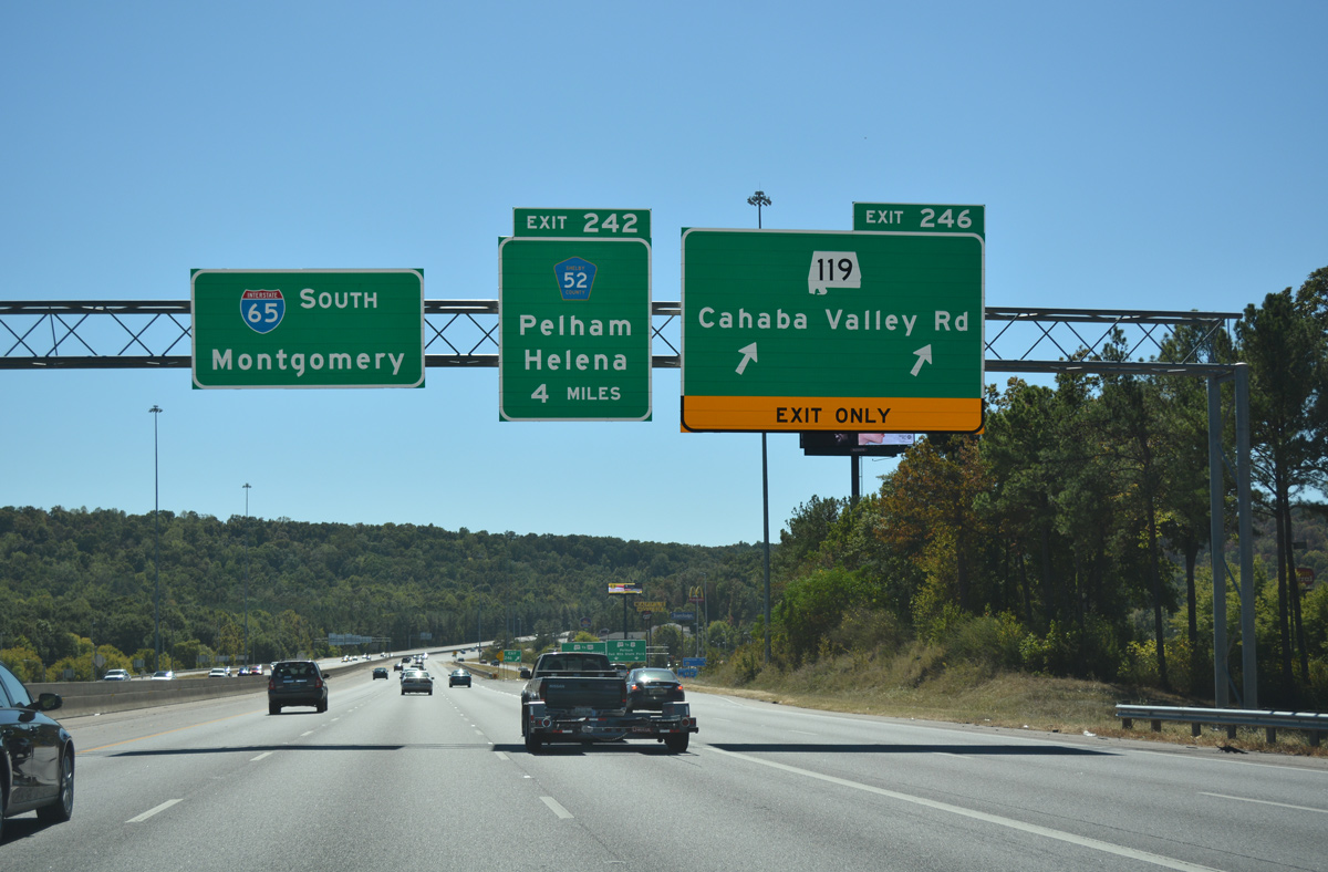
| Interstate 65 ascends over New Hope Mountain ahead of Exit 246 with SR 119 (Cahaba Valley Road). December 2010 completed work expanded I-65 to six overall lanes through Exit 246 to 242. 10/09/16 |
|
| A fifth southbound lane opens along I-65 south to the diamond interchange (Exit 246) with SR 119. SR 119 follows Cahaba Valley Road east between New Hope Mountain and Little Oak Ridge. The state route continues to the Indian Springs Village and New Hope communities within the town of Indian Springs, and Oak Mountain State Park. 10/09/16 |
|
| Exit 246 departs Interstate 65 south for SR 119 (Cahaba Valley Road). Heading south, SR 119 combines with U.S. 31 for 6.82 miles through Pelham and Alabaster. Overall the state route totals 39.625 miles between U.S. 78 at Leeds and SR 25 at Montevallo. 10/09/16 |
|
| A bevy of businesses and office buildings line SR 119 between Exit 246 and parallel U.S. 31 (Pelham Parkway). Eastward the state route is more suburban in nature through Cahaba Valley to U.S. 280 and Lake Purdy. 11/07/11 |
|
| Widening of Interstate 65 south through Fungo Valley added a third in lane in each direction within the freeway median. 06/25/12 |
|
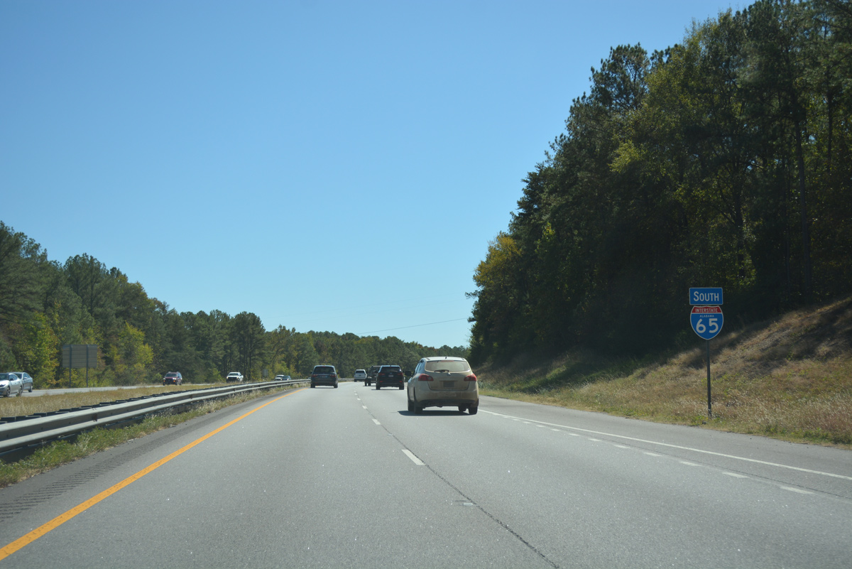
| Montgomery is now around an hour's drive to the south. The ensuing exit serves Pelham again. 10/09/16 |
|
| The freeway next meets Shelby County 52 in one mile at a diamond interchange (Exit 242). 10/09/16 |
|
| One half mile out from two lane off-ramp (Exit 242) to County Road 52. CR 52 links Interstate 65 with CR 11 near Deerhurst to the east and U.S. 31 & SR 119 (Pelham Parkway) to the west. 10/09/16 |
|
| West from Exit 242, CR 52 continues from an implied overlap with Pelham Parkway to SR 261 at Helena, and again from SR 261 to Morgan, Interstate 459 at Exit 6 and the city of Bessemer. 10/09/16 |
|
| Interstate 65 reduces from six to four overall lanes south of Shelby County 52. 10/09/16 |
|
| The next round of widening for Interstate 65 will focus on the four mile stretch to Alabaster. 10/09/16 |
|
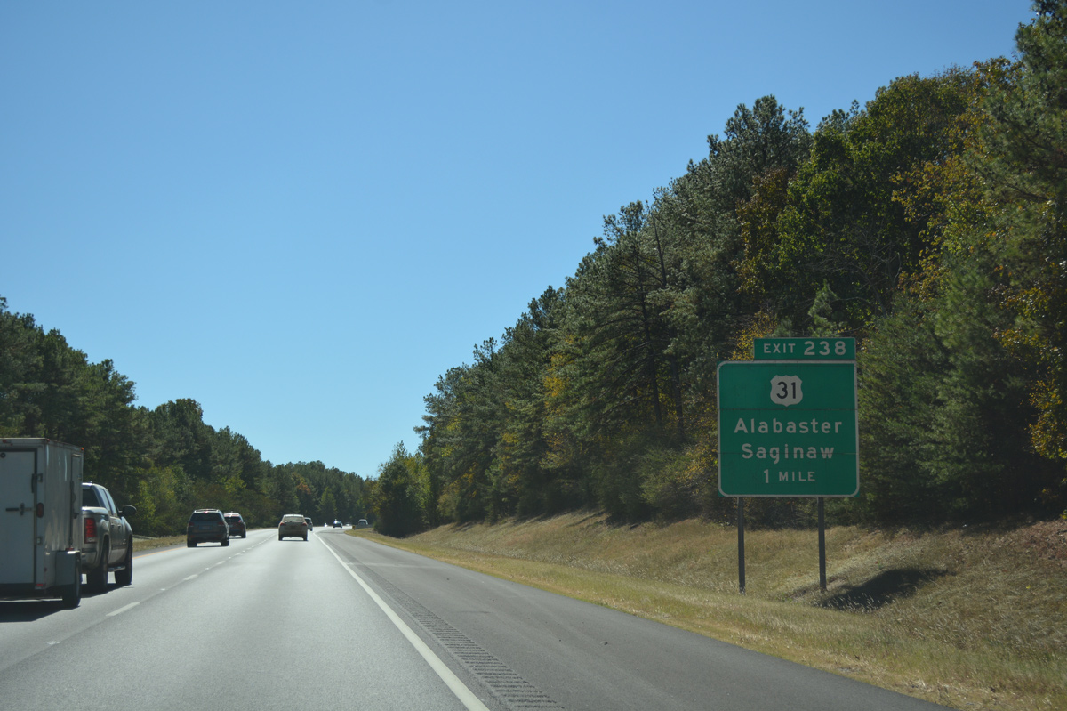
| Interstate 65 begins to turn southeasterly on a trajectory to the Alabama capital city. While doing this, U.S. 31 crosses the freeway from Alabaster to the northwest to the community of Saginaw. 10/09/16 |
|
| One half mile north of the diamond interchange (Exit 238) with U.S. 31 (1st Street South / Montgomery Highway). U.S. 31 joins SR 119 (Montevallo Road) north through Alabaster nearby. Southward, Shelby County 26 stems east from U.S. 31 at Saginaw to SR 70 outside the county seat of Columbiana. 10/09/16 |
|
| Exit 238 parts ways with Interstate 65 south at what locals dub the "Promenade Interchange". The exit attained its name after the adjacent Colonial Promenade Alabaster shopping center opened in 2005. U.S. 31 loops east by quarries and other industrial businesses from Saginaw south to Varnons, Dargin, Exit 231 and the city of Calera. 10/09/16 |
|
| ALDOT recorded 58,610 vehicles per day (vpd) along Interstate 65 south from Alabaster in 2015. 10/09/16 |
|
| Interstate 65 continues south ten miles to the Calera city center and an hour drive to Montgomery. 10/09/16 |
|
| Shelby County 87 branches south from U.S. 31 through Longview to meet Interstate 65 at Exit 234 alongside Shelby County Airport (EET). 10/09/16 |
|
| One half mile out from the parclo interchange (Exit 234) with Shelby County 87. CR 87 ends at CR 12 (Smokey Road) nearby; CR 12 connects with CR 22 west to SR 119 at Moores Crossroads in Montvallo. Interests to the University of Montevallo and The American Village are advised to use Exit 234 to SR 119 south. 10/09/16 |
|
| County Road 87 passes over Interstate 65 and turns south alongside the freeway at the Exit 234 off-ramp. Shelby West Parkway stems north from the county road turn to the airport and an adjacent industrial park. 10/09/16 |
|
| Confirming marker posted south of the CR 87 on-ramp. 10/09/16 |
|
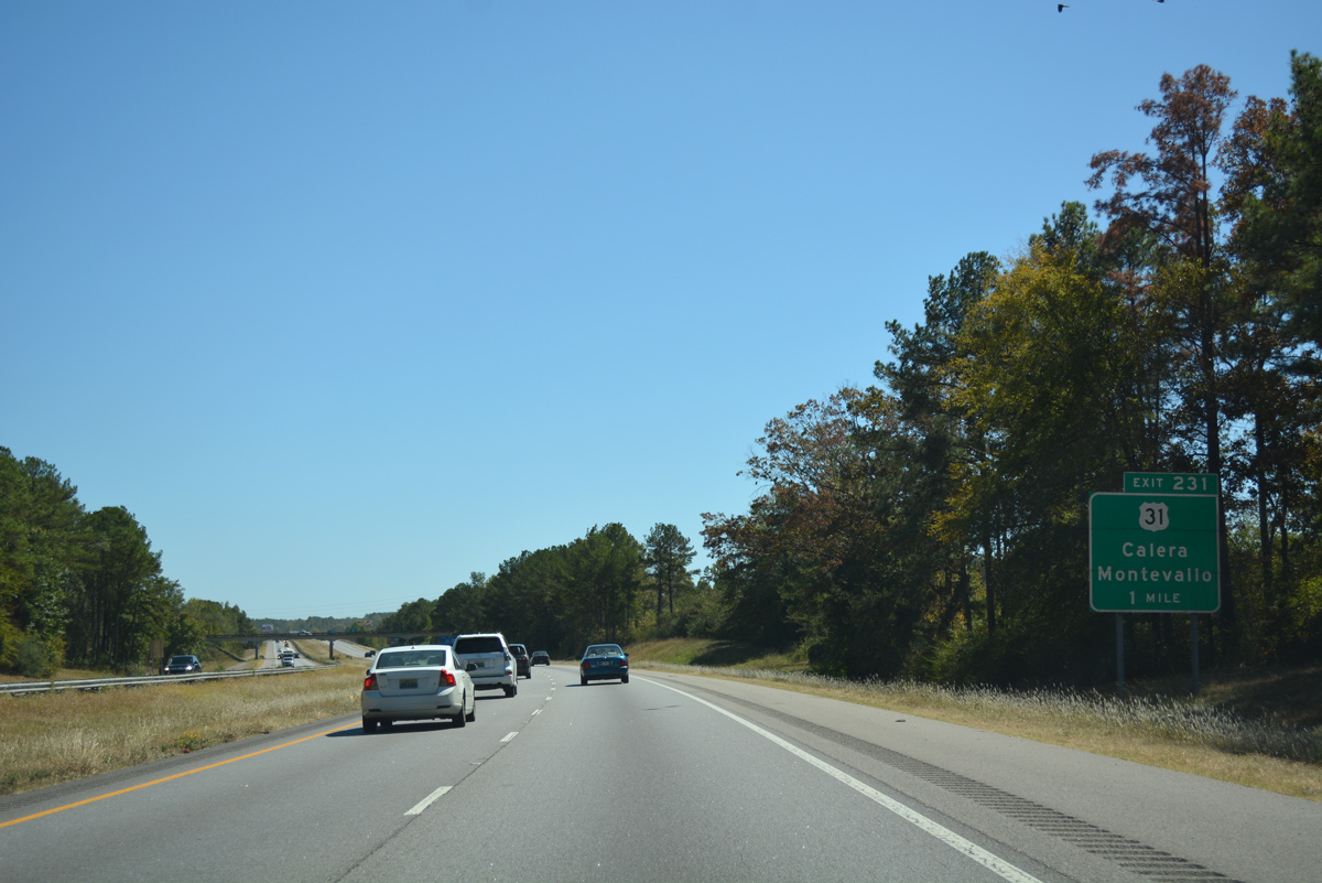
| There is no direct access to County Road 22 east to SR 70 and Columbiana. Southbound motorists instead must use U.S. 31 via Exit 231 to make the connection with the 8.29 mile state route. 10/09/16 |
|
| Control cities for U.S. 31 at Exit 231 include Calera for the city center south along Montgomery Highway and Montevallo via U.S. 31 north to County Road 22 west or south to SR 25 west. 10/09/16 |
|
| Traffic to U.S. 31 (Montgomery Highway) departs Interstate 65 south at Exit 231. U.S. 31 stays west of the freeway through Jemison, Thornsby and Clanton before meeting I-65 again at Exit 205. 10/09/16 |
|
| Interstate 65 was resurfaced south from Exit 231 in 2011. 10/09/16 |
|
| The freeway cuts a swath through eastern reaches of Calera on an increasingly rural drive south 65 miles to Montgomery. 10/09/16 |
|
| Meeting Interstate 65 at the final Shelby County interchange is SR 25 (University of Montevallo Highway). The state route joins Calera and Montevallo, seven miles to the west and travels 257.35 miles overall between SR 5 at Sunny South and the Georgia state line as the state route counterpart to U.S. 411. 10/09/16 |
|
| Entering the diamond interchange (Exit 228) with SR 25 (University of Montevallo Highway) along Interstate 65 south. SR 25 leads northeast 9.5 miles to Columbiana and 27.6 miles to Harpersville and U.S. 280. Westward the state route shares a two block overlap with U.S. 31 and then continues 25 miles from Calera to Centreville. Exit 228 also serves interests to Brierfield Ironworks State Park. 10/09/16 |
|
| Southbound motorists span a CSX Railroad line and Buxahatchee Creek over a 1960-built bridge along the Calera city line. 11/07/11 |
|
| 45 of the 62 miles to Montgomery are vastly rural along Interstate 65 through Chilton and Autauga Counties. The small city of Jemison lies 13 miles ahead via Exit 219. 10/09/16 |
|
| Interstate 65 concludes the 22.62 mile drive within Shelby County as the freeway crosses into Chilton County, east of South Calera. 11/07/11 |
Page Updated 05-16-2017.

 South
South