3.38 miles long, Interstate 194 provides a direct link between Interstate 94 near Lakeview Square Mall and the Central Business District of Battle Creek. Commonly referred to as the "Penetrator", Interstate 194 was designated in 1961 and completed by 1966.1 The lone branch route of Interstate 94 in Michigan, I-194 is paired its entire length with M-66 along the Sojourner Truth Downtown Parkway from a cloverleaf interchange with I-94 north to Hamblin Avenue just south of Downtown Battle Creek.
|
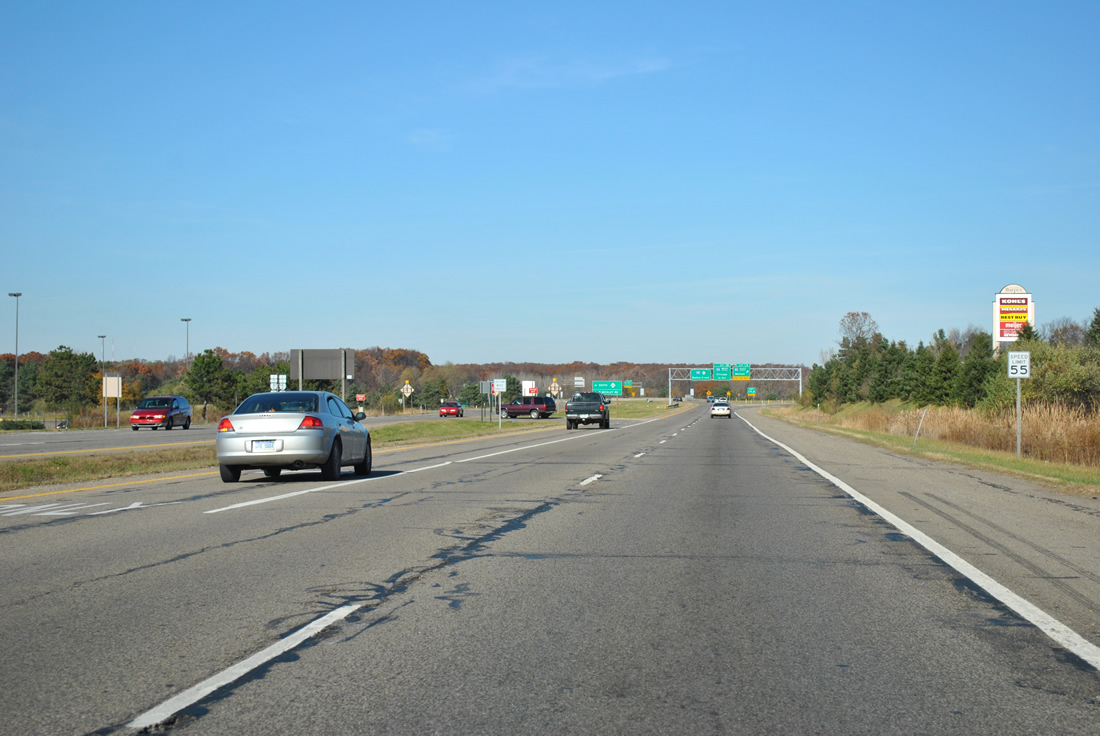
| M-66 widens to a four lane divided highway on the approach to Beckley Road. Beckley Road shoots east from M-66 to become B Drive after 6 Mile Road. Both Beckley Road and B Drive also serve as a local emergency route for I-94 when the freeway is impassible or closed. The seasonal Binder Park Zoo located nearby and is reached via Beckley Road / B Drive east to 8 Mile Road south. 11/05/11 |
|
| The state trunkline route continues north from Beckley Road between Lakeview Square Mall and Village Harper retail center as it approaches the cloverleaf interchange with Interstate 94 and 194 in 0.3 mile. 11/05/11 |
|
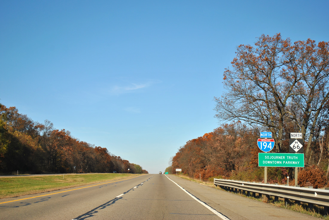
| A U-turn is provided for traffic bound for M-66 south and Beckley Road west prior to the beginning of the freeway to Downtown Battle Creek. Beckley Road continues west from M-66 as a commercial arterial to Capital Avenue before returning to a rural setting. M-66 south quickly leaves the urban area of Battle Creek as a two lane highway toward Leroy Township and Sturgis. The state trunkline route transitions into Indiana 9 42.5 miles to the south and immediately meeting the Indiana Toll Road (I-80 & 90). 11/05/11 |
|
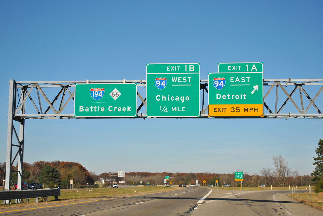
| Interstate 194 begins its 3.38 mile stint into Downtown at (Exits 1A/B) with Interstate 94 in southeastern Battle Creek. M-66 will carry I-194 northward from its parent to Hamblin Avenue near the CBD, where the 268.95 mile2 state trunkline highway continues to Nashville in adjoining Barry County. Exit 1A leads to Interstate 94 east and the Motor City while an upcoming loop ramp takes motorists to I-94 west and the Windy City. 11/05/11 |
|
| Interstate 94 stretches across the lower peninsula over 275 miles from Indiana near New Buffalo in the southwest corner to Port Huron near the St. Clair River and Ontario, Canada. The freeway continues westward from I-194 and Battle Creek passing Kalamazoo and St. Joseph to the south en route to Chicago, Illinois, 165.7 miles away. 11/05/11 |
|
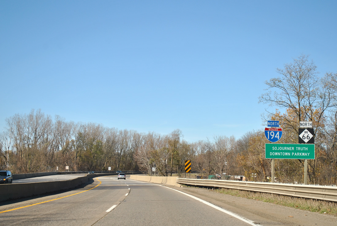
| First reassurance shield for Interstate 194 north as it continues on toward Downtown with M-66. The freeway is also designated the Sojourner Truth Downtown Parkway, named in honor of Isabella Baumfree, an abolitionist and women's rights activist in the mid-1800's. She took on the name Sojourner Truth in June 1843 and began traveling and preaching about abolishing slavery, later moving to the Battle Creek area.3 An amendment in 1993 added the designation in order to restore a link between Truth and the City of Battle Creek.4 11/05/11 |
|
| Interstate 194 and M-66 approach a diamond interchange with M-96 (Columbia Avenue) in one mile. Exit 2 was the first terminus of the I-194 numbering when it was established in 1961, with the final 1.3 mile extension of the freeway opening to Hamblin and Michigan Avenues by 1966. M-96 stretches nearly 36.8 miles from Business Loop I-94 in Kalamazoo and Interstate 69 west of Marshall. 11/05/11 |
|
| A departure ramp leaves for Exit 2 and M-96 (Columbia Avenue) immediately north of Golden Avenue. The state trunkline highway follows Columbia Avenue through Springfield Place and Sunrise Heights as it skirts Battle Creek to the south. The interstate will meet the business loop for Battle Creek one mile ahead. 11/05/11 |
|
| The duo span the Kalamazoo River between M-96 and the parclo interchange with Business Loop I-94 (Dickman Road). The 130 mile river flows from two branches near Albion to Lake Michigan northwest of Saugatuck, passing through Marshall, Battle Creek, Kalamazoo, and Otsego in between. Waters from the 54 mile long Battle Creek River merge into the Kalamazoo west of Downtown. Work commenced in April 2013 to rehabilitate the bridges over the Kalamazoo River, upcoming Business Loop I-94 (Exit 3), rail lines and Fountain Street, as well as general sign and lighting replacement.5 11/05/11 |
|
| Business Loop I-94 constitutes a 13.95 mile route through the heart of Battle Creek connecting with Interstate 94 west at the Calhoun county line (Exit 92) and Interstate 94 east at 11 Mile Road (Exit 104). The route generally follows portions of Columbia Avenue, Martin Luther King Jr. Drive (former Skyline Drive), Dickman Road and Michigan Avenue as it traverses Battle Creek. 11/05/11 |
|
| Still in the confines of Exit 3 (Dickman Road) drivers are alerted to the end of the freeway in one half mile. The transition of the freeway also marks the northern terminus of Interstate 194. 11/05/11 |
|
| Northbound Interstate 194 and M-66 pass over Business Loop I-94 on the final approach to Hamblin Avenue. Dickman Road ends three blocks to the east at Main Street where the business loop briefly turns northwest to meet Hamblin Avenue and Michigan Avenue just east of the terminus of I-194. BL I-94 continues southeast along Michigan Avenue toward Marshall. 11/05/11 |
|
| Two short viaducts carry the freeway over a pair of Amtrak rail lines and Fountain Street prior to meeting Hamblin Avenue. Interests to Kellogg Arena and Full Blast Family Center will depart ahead at Hamblin Avenue west. 11/05/11 |
|
| Interstate 194 north ends its short journey into Battle Creek at Hamblin Avenue. Use Hamblin Avenue east to reach Michigan Avenue and Business Loop I-94. M-66 continues into Downtown along Division Street crossing over the Battle Creek River before merging onto Capital Avenue toward Nashville. 11/05/11 |
|
| M-66 and Division Street will next meet Michigan Avenue at the following signalized intersection. Michigan Avenue stems southeast from Division Street and Hamblin Avenue and will carry both BL I-94 and M-96 out of Battle Creek toward Marshall. Going northwest Michigan Avenue will join M-89 north at Washington Avenue as it leaves Battle Creek for Richland and Plainwell. 11/05/11 |
|
| Interstate 194 south begins immediately following the at-grade intersection with Hamblin Avenue along M-66 (Division Street). The 3.38 mile limited-access freeway quickly rises above Fountain Street and two Amtrak rail lines before departing for Exit 3 and Business Loop I-94 (Dickman Road). The business loop encompasses 13.95 miles from Interstate 94 (Exit 92) in west Calhoun County to Battle Creek with a return trip to Interstate 94 at Exit 104 (11 Mile Road). M-96 lies 0.75 miles further to the south of the upcoming Kalamazoo River crossing. 11/05/11 |
|
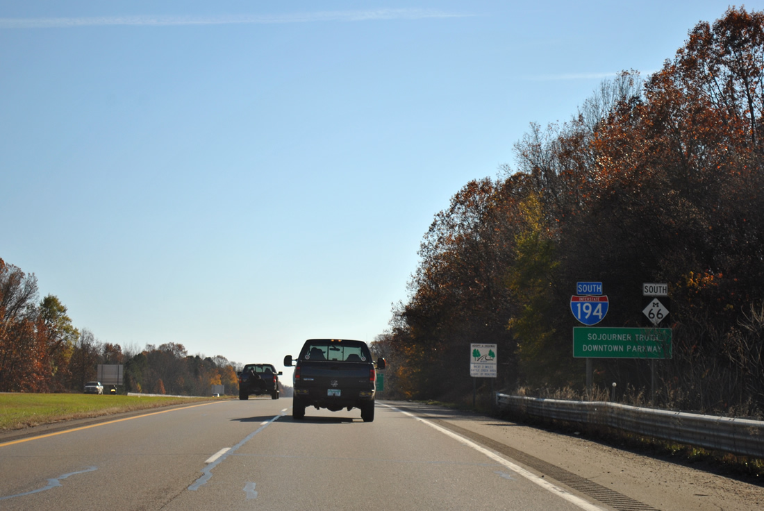
| Drivers see the first shield assembly for Interstate 194 and M-66 south of Business Loop I-94 (Dickman Road). This stretch of freeway is named in honor of Sojourner Truth, an abolitionist and women's rights activist in the mid-1800's. Isabella Baumfree took on the name Sojourner Truth in June 1843 and began traveling and preaching about abolishing slavery, later moving to the Battle Creek area.3 An amendment in 1993 added the designation in order to restore a link between Truth and the City of Battle Creek.4 11/05/11 |
|
| An auxiliary lane will take motorists to Exit 2 and Columbia Avenue in one-quarter mile. M-96 follows Columbia Avenue west from the freeway through commercial retail to Helmer Road where the state route turns north. Columbia Avenue continues west another 2.2 miles to meet BL I-94 and M-37 (Dr. Martin Luther King Jr. Drive) southwest of W.K. Kellogg Airport (BTL). 11/05/11 |
|
| The duo reach the departure ramp for M-96 (Exit 2). Columbia Avenue carries M-96 west to Helmer Road where the state trunkline route continues north toward Dickman Road (BL I-94). Going east, M-96 follows Columbia Avenue to Michigan Avenue where the state highway joins BL I-94 for a 3.2 mile overlap back to Interstate 94. 11/05/11 |
|
| Interstate 194 will come to an end in two miles at the cloverleaf interchange (Exits 1B/A) with Interstate 94 in south Battle Creek. Interstate 94 extends west toward the Windy City (Chicago) and east to the Motor City (Detroit). 11/05/11 |
|
| Motorists from M-96 (Columbia Avenue) are greeted with a reassurance assembly for southbound Interstate 194 and M-66 as the freeway continues toward Interstate 94 (Exits 1B/A). 11/05/11 |
|
| Interstate 94 stretches nearly 275.4 miles from the extreme southwest corner of the Great Lakes State to Port Huron along the St. Clair River passing near or through St. Joseph, Kalamazoo, Battle Creek, Jackson, Ann Arbor and Detroit along the way. The interstate joins I-69 the last four miles before crossing over to Ontario, Canada via the Blue Water bridge to the Ontario 402 freeway. 11/05/11 |
|
| A shield assembly prior to the cloverleaf interchange alerts drivers to the upcoming end of Interstate 194. 11/05/11 |
|
| The freeway reaches the ramp departure for Exit 1B to Interstate 94 west. Chicago lies to the west 165.7 miles along the western shores of Lake Michigan. Interstate 94 east traffic will leave for Detroit in one-quarter mile with M-66 forging southward toward Sturgis in the Indiana border. 11/05/11 |
|
| Interstate 194 comes to an official end as a loop ramp leaves for Interstate 94 east and Detroit. The central business district of the Motor City lies 118 mile due east of Exit 1A. M-66 continues south toward Beckley Road and Leroy Township in south Calhoun County with Sturgis still being a 41.8 mile drive ahead. 11/05/11 |
|
| M-66 south transitions from limited-access to arterial status as it approaches the at-grade intersection with Beckley Road. The state trunkline highway bisects Lakeview Square Mall to the west and Village Harper retail center to the east on the approach to the local road. Beckley Road also acts as a local emergency route for Interstate 94 through the Battle Creek area. 11/05/11 |
|
| Drivers are advised to continue through the Beckley Road intersection to access the road to the east via an upcoming "Michigan Left". Binder Park Zoo (7400 Division Drive) can be reached via Beckley Road and B Road east to 8 Mile Road south. 11/05/11 |
|
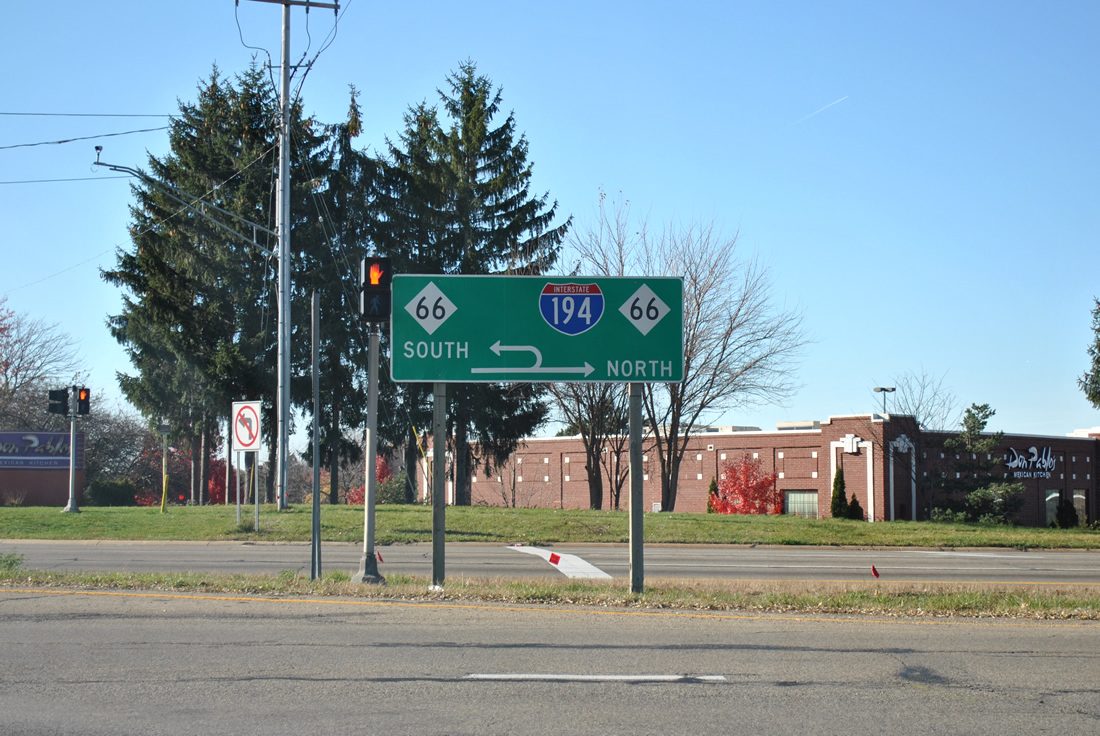
| Guide signs direct motorists of a return to northbound M-66 and Beckley Road south of the intersection. Interstate 194 is also mentioned for motorists stemming from Beckley Road west to access the interstate north to Downtown Battle Creek. M-66 becomes a two lane rural route immediately to the south as it continues toward Athens and Sturgis. 11/05/11 |
|
| Motorists are advised to keep right for the upcoming turn to M-66 and Interstate 194 along Beckley Road in Emmett Township. Beckley Road continues B Drive west through south Battle Creek parallel to Interstate 94. The commercial arterial will see a direct interchange with the freeway in one mile at Capital Avenue. 11/05/11 |
|
| This portion of Beckley Road also serves as a local emergency route for Interstate 94 west. The emergency route follows Beadle Lake Road south from I-94 (Exit 100) to B Drive where it turns west for a return to the freeway via Beckley Road and M-66 north. 11/05/11 |
|
| A "Michigan Left" provides movement to M-66 south from Beckley Road west with a U-turn situated before the northbound beginning of Interstate 194. M-66 continues south from Interstate 94 and Beckley Road as a two lane rural highway through Leroy Township and Athens before exiting into Branch County. Going north M-66 will carry I-194 into Downtown Battle Creek. 11/05/11 |
Page Updated 10-26-2013.