SR 10 Loop, the Athens Perimeter Highway, encircles Athens along a 19 mile course. The limited access highway also carries portions of U.S. 29, U.S. 78, U.S. 129 and U.S. 441. Interchanges are numbered Exits 1 through 20, counter clockwise from U.S. 78/SR 10. The state route uses inner and outer direction banners.
The Athens Perimeter Highway was previously signed with north or south direction banners and exit numbers were orientated in a clockwise direction. The Georgia Department of Transportaton (GDOT) added the designation of SR 422 to the loop in 2000. Like other 400 series state routes in Georgia, the route number is unmarked.
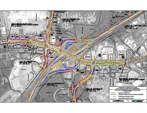
A new parclo interchange (Exit 9) was constructed with Peter Street west and Olympic Drive east in 2012-14. This replaced an at-grade intersection.
Changes outlined for the parclo interchange (Exit 18) joining SR 10 Loop with U.S. 78 Business/SR 10 near Georgia Square Mall addressed ramp geometry and added a loop ramp from Atlanta Highway west to the Outer Loop of the Athens Perimeter Highway. This project began in 2019.
|
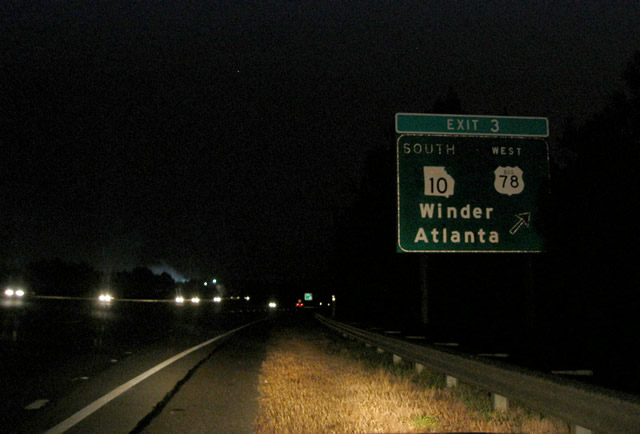
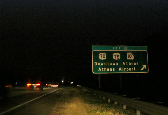
| Long since replaced button copy sign posted at the parclo interchange (Exit 18 / old Exit 3) with U.S. 78 Business/SR 10 (Atlanta Highway) on the inner loop of the Athens Perimeter Highway. Atlanta Highway constitutes a commercial arterial leading U.S. 78 Business west 2.4 miles to Monroe Highway. 01/17/04 |
|
| Approaching Exit 14 (old Exit 7) with U.S. 129/SR 15 Alternate (Prince Avenue) on SR 10 Loop eastbound. Prince Avenue angles southeast from the freeway to Downtown Athens, partially along the former route of U.S. 129/441. U.S. 129 north travels 15 miles to Jefferson. 01/17/04 |
|
| U.S. 129 south combines with SR 10 Loop east to Exit 12 (old Exit 9), where U.S. 441/SR 15 south tie into the Athens Perimeter Highway. U.S. 441 joins Athens with Commerce, 16 miles to the north. U.S. 441 south follows the freeway loop south with U.S. 129 to Exit 4 (Macon Highway). 01/17/04 |
|
| Continuing east from North Avenue (Exits 11B/A), SR 10 Loop meets U.S. 29 at a three quarter cloverleaf interchange (Exits 10C/D / old Exit 11). U.S. 29 south combines with U.S. 129-441/SR 10 Loop to loop around Athens to the east and south. U.S. 29 north splits with SR 72 east to Elberton in 1.2 miles. 01/17/04 |
|
| U.S. 78 accompanies SR 10 Loop and U.S. 129-441/SR 8-15 southwest from Lexington Road. The six route overlap crosses the North Oconee River ahead of the diamond interchange (Exit 7) with College Station Road. 10/03/10 |
|
| College Station Road leads west from Exit 7 to East Campus Road and the University of Georgia. The four lane arterial extends southeast to Barnett Shoals Road at College Station Shopping Center. 10/03/10 |
|
| Trailblazer signage posted ahead of the College Station Road underpass directs motorists headed for SR 316 west, U.S. 129 north and U.S. 441 north to remain along the Athens Perimeter Highway west into Oconee County and north back into Athens. A shorter route to the U.S. Highways north is to turn around at forthcoming Exit 6. 10/03/10 |
|
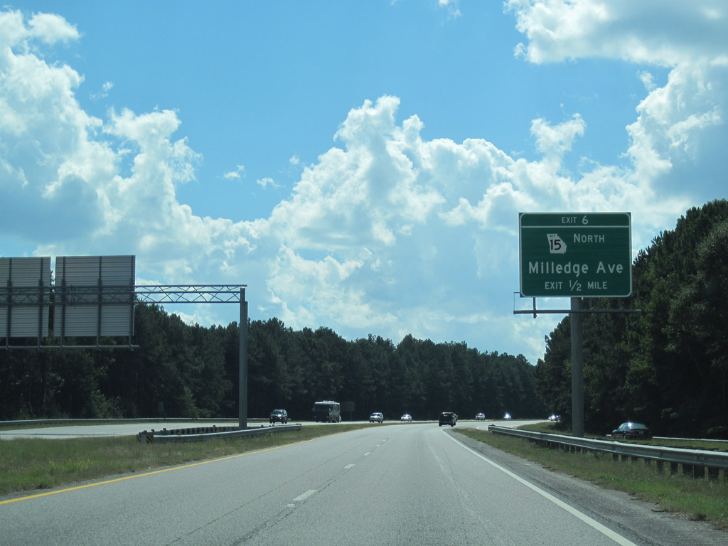
| Curving west by Oconee Forest Park, the Athens Perimeter Highway advances toward the modified diamond interchange (Exit 6) with SR 15 Alternate (Milledge Avenue) north. 10/03/10 |
|
| SR 15 Alternate follows the pre-freeway alignment of U.S. 129/441 north along Milledge and Prince Avenues through Athens to SR 10 Loop at Exit 14. Macon Highway stems west from Milledge Avenue and Exit 6 as the old alignment of U.S. 129/441 into Oconee County. 10/03/10 |
|
| U.S. 129/441 and SR 15 branch south from SR 10 Loop at the subsequent westbound exit for Macon Highway south and Timothy Road north. 10/03/10 |
|
| Confirming marker for SR 10 Loop inner posted ahead of the Middle Oconee River. The Athens Perimeter Highway is formally named Paul Broun Parkway. 10/03/10 |
|
| U.S. 129/441 overlap south from Athens to the Oconee County seat of Watkinsville and the Morgan County seat of Madison. 10/03/10 |
|
| Exit 4B departs for Timothy Road northwest to Epps Bridge Parkway and U.S. 78 Business (Atlanta Highway). 10/03/10 |
|
| Heading south from Exit 4B with SR 10 Loop, U.S. 129/441 (Macon Highway) travel 2.7 miles to the Madison bypass and 49.3 miles to their split at Eatonton. 10/03/10 |
|
| U.S. 29 south, U.S. 78 west and SR 10 Loop inner cross McNutt Creek into Oconee County within the parclo interchange at Timothy Road. 10/03/10 |
|
| Another set of trailblazers direct motorists to remain along Georgia Loop 10 inner back around to the north side for U.S. 129 and U.S. 441 north. 10/03/10 |
|
| SR 10 Loop runs along a rural stretch to the north of Barber Creek. 10/03/10 |
|
| U.S. 29 south / U.S. 78 west part ways with SR 10 Loop and combine with SR 316 west from Exit 1 in a mile. 10/03/10 |
|
| U.S. 78 angles southwest from U.S. 29, 3.7 miles west of Exit 1, along a four lane divided highway to the Walton County seat of Monroe. 10/03/10 |
|
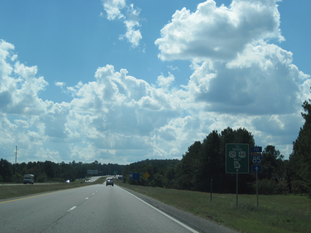
| Travelers destined for Interstate 85 are partitioned to use SR 316 west from Athens to southbound, and U.S. 441 north from Exit 12 for northbound. 10/03/10 |
|
| The Athens Perimeter Highway inner loop reaches the parclo A2 interchange (Exit 1) with Epps Bridge Parkway east and U.S. 29-78/SR 8-316 west. SR 316 travels 39 miles along an expressway west to Interstate 85 near Duluth. 10/03/10 |
|
| U.S. 29/SR 316 combine west to Lawrenceville. Epps Bridge Parkway ties into SR 10 Loop from a big box retail area to the east. 10/03/10 |
|
| Button copy sign formerly posted along U.S. 29-78/SR 8-10 Loop east at the parclo interchange (Exit 4 / old Exit 17) with U.S. 129-441/SR 15 (Macon Highway). SR Loop 10/U.S. 78 eastbound at Exit 17 (U.S. 129-441/SR 15 south). U.S. 129/441 lead south from the Athens Perimeter Highway to Watkinsville and Bishop en route to Madison. U.S. 129/441 overall overlap 56 miles between Eatonton and Athens. 01/17/04 |
|
| U.S. 129/441 north accompany SR 10 Loop around the east side of Athens to bypass Downtown. SR 15 Alternate follows their previous alignment north along Milledge Avenue from Exit 6 / old Exit 15. 01/17/04 |
|
| U.S. 78 rejoins SR 10 east from SR 10 Loop at the folded diamond interchange (Exit 8 / old Exit 13) with Oconee Street. Lexington Road leads the two routes east from the freeway to Athens-Ben Epps Airport (AHN) and Oglethorpe County. 01/17/04 |
|
| This diagrammatic sign preceded the half diamond interchange (Exit 10A / old Exit 11A) with Old Hull Road and the western turn of SR 10 Loop, where it separates with U.S. 29 north. 01/17/04 |
|
| A loop ramp (Exit 10B / old Exit 11) represents the mainline of U.S. 129-441/SR 15 north and SR 10 Loop outer. The freeway otherwise defaults onto U.S. 29 north to Danielsville. 01/17/04 |
|
| Leading west from U.S. 29, drivers on the Athens Perimeter Highway quickly enter a parclo B2 interchange (Exit 11 / old Exit 10) with Danielsville Road and North Avenue. Danielsville Road is an old alignment of U.S. 29. 01/17/04 |
|
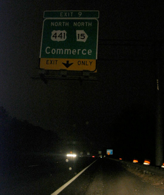
| The entrabce ramp from Danielsville Road forms an auxiliary lane along the outer loop of SR 10 Loop to split with U.S. 441/SR 15 north to Commerce. 01/17/04 |
|
| Curving southeast, the outer loop of SR 10 Loop meets U.S. 29/78 at Epps Bridge Parkway and Exit 1. The exchange represents the east end of SR 316, an expressway joining Athens with the Atlanta area via I-85. 01/17/04 |
Photo Credits:01/17/04, 10/03/10 by AARoads
Connect with:
U.S. 29
U.S. 78
U.S. 129
U.S. 441
State Route 316
Page Updated 06-28-2017.


 Inner
Inner