
SR 46 spans the St. Johns River between Volusia and Seminole Counties over the George C. Means Memorial Bridge. 09/12/22
 West
West
SR 46 follows W Main Street from U.S. 1 in the unincorporated community of Mims. No confirming marker is posted at the westbound beginning.
09/12/22

Unsigned CR 405 ties into SR 46 (W Main Street) from Singleton Avenue north across from Folsom Road in Mims. This reassurance marker follows westbound.
09/12/22

Leading west from Mims, SR 46 plies across a swamp to Palm Avenue.
09/12/22

SR 46 travels 1.25 miles west from U.S. 1 at Mims to the intersection of Pine Avenue north and Holder Road south.
09/12/22

A diamond interchange (Exit 223) connects SR 46 with Interstate 95 west of Australian Way.
09/12/22

09/12/22

FDOT District 5 signage for I-95 generally utilizes Jacksonville in place of Daytona.
09/12/22

Heading north from the Mims area, Interstate 95 travels along a rural course to the west of New Smyrna Beach, Port Orange and the outskirts of Daytona Beach.
09/12/22

Interstate 95 travels south to Titusville, Cocoa and Melbourne along Florida's Space Coast.
09/12/22

09/12/22

09/12/22

09/12/22

Turpentine Road south provides part of a route from SR 46 to Salt Lake Wildlife Management Area.
09/12/22

SR 46 crosses Six Mile Creek and wetlands spreading north from Salt Lake.
09/12/22

09/12/22

Angling northwest by Buck Lake, SR 46 enters the southern wedge of Volusia County.
09/12/22

09/12/22

09/12/22

09/12/22

09/12/22

SR 46 travels 5.44 miles northwest through Volusia County into Seminole County across the St. Johns River.
09/12/22

09/12/22

C.S. Lee Park lines the west banks of the St. Johns River along SR 46.
09/12/22

Continuing northward by Lake Proctor, SR 46 west enters the unincorporated community of Geneva.
09/12/22

County Road 426 runs 7.78 miles southwest to SR 434/CR 419 in the city of Oviedo. 1st Street extends north from SR 46 into the Geneva street grid.
09/12/22

09/12/22

Heading west from the intersection with Osceola Road, SR 46 runs along the boundary of Lake Jessup Conservation Area to the St. Johns River.
09/12/22

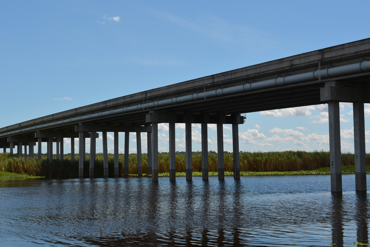
The original Geneva Bridge spanning the St. Johns River and adjacent wetlands along SR 46 was replaced by a higher bridge built to the south in 2008-09. Accommodating two lanes and full shoulders across a 44 foot wide deck, the George C. Means Memorial Bridge measures 3,742.3 feet in length.1
09/12/22

Traveling across northern reaches of Lake Jesup, SR 46 lowers from the St. Johns River bridge at Cameron Wight Park & Boat Ramp.
09/12/22

SR 46 briefly enters Volusia County again over an island within the St. Johns River.
09/12/22

Heading to the city of Sanford, SR 46 meets SR 415 north and Lake Mary Boulevard south.
09/12/22

SR 415 joins northeast Seminole County with Osteen and Deltona in Volusia County. Opened in 2006, Lake Mary Boulevard is an arterial linking SR 46/415 with Cameron City and Orlando-Sanford International Airport (SFB).
09/12/22

SR 415 travels 18.5 miles overall between SR 46 / Lake Mary Boulevard and SR 44. CR 415 extends the route another 11.4 miles to U.S. 92 in Daytona Beach. A second branch of CR 415 stems west from SR 415 nearby along Celery Avenue toward central Sanford. Lake Mary Boulevard south and west eventually meets SR 417 (Seminole Expressway) at CR 427 (Ronald Reagan Boulevard).
09/12/22

West from SR 415 and Lake Mary Boulevard, SR 46 enters the Beck Hammock neighborhood in east Sanford.
09/12/22

The unincorporated community of Midway spreads north from SR 46 west of Beardall Avenue to Brisson Avenue.
09/12/22

SR 46 wholly enters the city of Sanford westbound ahead of the Wynwood neighborhood.
09/12/22

Mellonville Avenue (CR 4201) intersects SR 46 (E 25th Street) at a fire signal. Unsigned CR 4201 forms a 2.96 mile long loop to Lake Monroe north of Downtown Sanford.
09/12/22

No longer acknowledged along SR 46 (25th Street) westbound, forthcoming Sanford Avenue is part of CR 425 south 1.62 miles to Ronald Reagan Boulevard (CR 427).
03/21/08

Sanford Avenue extends north from SR 46 (E 25th Street) and CR 425 to CR 415 (Celery Avenue) and Historic Downtown Sanford.
09/12/22

Park Drive branches northeast from U.S. 17/92 to SR 46 (E 26th Street) at Park Avenue. Park Avenue (CR 4213) continues north to Downtown Sanford.
09/12/22

U.S. 17/92 (French Avenue) travel northeast into Sanford from Longwood, Winter Springs and Lake Mary.
09/12/22

SR 46 turns north onto U.S. 17/92 for 1.75 miles from 25th Street to 1st Street. Marked with trailblazers for SR 46, the overlap is not formally signed.
09/12/22

U.S. 17/92 overlap south through the Orlando metropolitan area to Lake Alfred in Polk County. The two combine northward from Sanford to DeBary, Orange City and DeLand.
09/12/22
 North
North  East West
CR 415 stems east from U.S. 17/92-SR 46 (French Avenue) along 13th Street to Sanford Avenue.
09/12/22

U.S. 17 north, U.S. 92 east and SR 46 west combine along West 1st Street three miles from French Avenue west of Downtown Sanford to Monroe Road. U.S. 17/92 was relocated from the remainder of French Avenue north and Seminole Boulevard along Lake Monroe in 2018.
09/02/19

Resuming a westward heading, SR 46 (1st Street) continues from Sanford to Wekiva Parkway (SR 429) and Lake County.
09/02/19

1st Street spans a CSX Railroad line ahead of the intersection with Airport Boulevard south and the entrance to Sunrail Sanford station. Airport Road is unsigned CR 425 south to Martin Luther King, Jr. Boulevard.
09/02/19

Opened to traffic in 2008, Martin Luther King, Jr. Boulevard replaced CR 425 along Airport Boulevard as the main route leading south from SR 46 to SR 417 (Seminole Expressway).
09/02/19

Central Park Drive north connects with U.S. 17/92 and SR 46 from Sanford Central Park opposite Old England Loop at the ensuing traffic light.
09/02/19

U.S. 17/92 part ways with SR 46 west at County Road 15 (Upsala Road) south and Monroe Road. U.S. 17/92 overtook the northern leg of CR 15 to I-4 and Seminole Boulevard at Lake Monroe.
09/02/19

SR 46 leads west toward Interstate 4 along a commercialized stretch in west Sanford. U.S. 17/92 follow Monroe Road 1.4 miles north to Interstate 4 ahead of DeBary in Volusia County.
09/02/19


Sources:
- SR-46 over Lake Jesup, Seminole County, Florida. BridgeReports.com
Photo Credits:
03/21/08, 09/02/19, 09/12/22 by AARoads
Connect with:
Interstate 95
U.S. 17
U.S. 92
U.S. 441
State Road 15 / County Road 15
State Road 415 / County Road 415
County Road 426
Page Updated 11-07-2022.