The original Wheeler Moses Bridge taking Interstate 95 across the Housatonic River between Stratford and Milford was constructed in 1958. Construction replacing the aging, 92 foot wide span commenced in September 2009. Completion of the northbound bridge occurred on December 7, 2013, with work on the southbound span continuing into 2017. The new bridge accommodates six overall lanes with full insider and outside shoulders across a 136 foot wide deck.1
|
| A parclo interchange joins Mill Plain Road and Interstate 95 at Exit 21 in one mile. 05/30/22 |
|
| A half diamond interchange (Exit 20 on I-95 south) adds traffic to I-95 north at the Mill River. 05/30/22 |
|
| Interstate 95 crosses the Mill River into Fairfield ahead of Exit 21 to Mill Plain Road and Exit 22 to Round Hill Road. 05/30/22 |
|
| Mill Plain Road heads 2.44 miles north from U.S. 1 (Post Road) and the Fairtown town center to Exit 21 and Brookside Drive at Burr Street. 05/30/22 |
|
| Exit 22 is a split diamond interchange for the Fairfield Service Plaza, Round Hill Road and Walls Road to Route 135 (Benson Road). Route 135 travels 2.58 miles north from U.S. 1 (Post Road) to Fairfield University and Route 58 (Black Rock Turnpike) in Fairfield. 05/30/22 |
|
| Exit 22 departs from I-95 north beyond this confirming marker and the Unquowa Road underpass. 05/30/22 |
|
| Round Hill Road extends 1.56 miles north from Beach Road and U.S. 1 (Post Road) to Round Hill and Mill Plain Road. 05/30/22 |
|
| Originally built in the 1950s, the Fairfield Service Plaza closed for reconstruction between March 2013 and March 2014 as part of a $178 million statewide project to rebuild 23 service areas along both the Connecticut Turnpike and Merritt Parkway.2 05/30/22 |
|
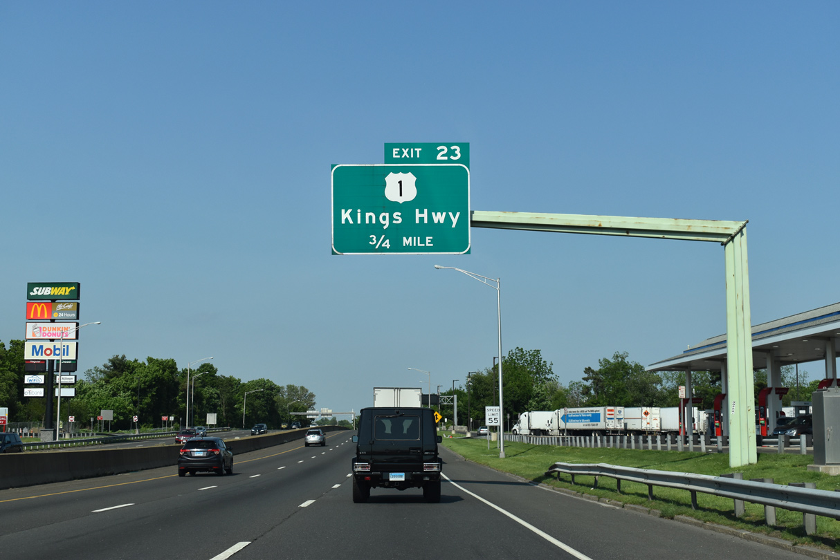
| U.S. 1 partitions into a one way couplet along Kings Highway Cutoff through the upcoming diamond interchange (Exit 23) at Meadowbrook Road. 05/30/22 |
|
| U.S. 1 diverges from Post Road along Kings Highway from Route 130 northeast to Interstate 95. 05/30/22 |
|
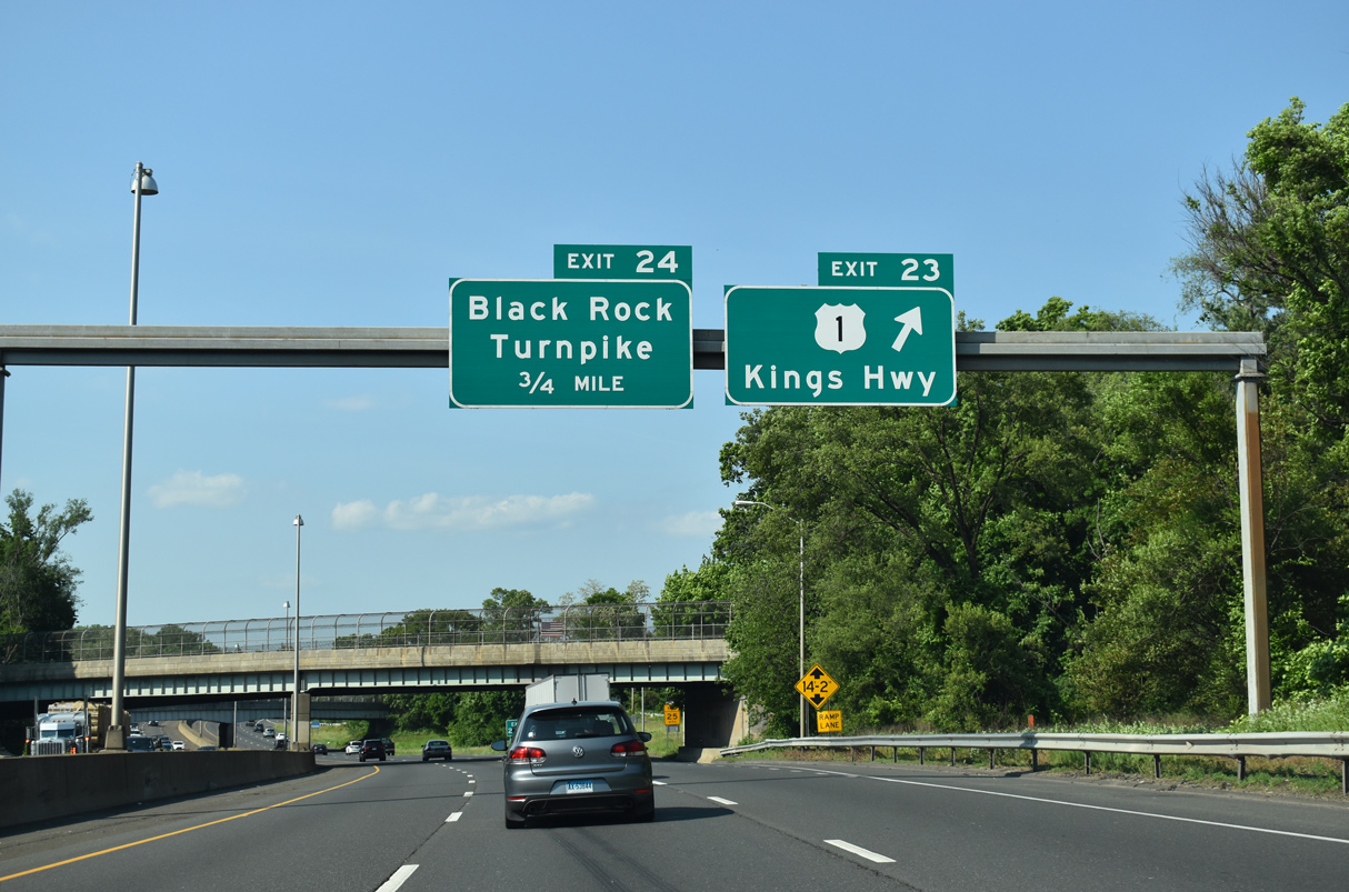
| U.S. 1 southbound passes over Interstate 95 at Exit 23 onto U.S. 1 north at Meadowbrook Road. U.S. 1 (Kings Highway Cutoff) parallels I-95 to the south along a commercial boulevard east to Black Rock Turnpike at Exit 24. 05/30/22 |
|
| Black Rock Turnpike extends 0.38 miles north from Brewster Street and the Bridgeport city line to a traffic circle with U.S. 1 (Kings Highway Cutoff) at Exit 24. Black Rock Turnpike (Route 732) continues north from U.S. 1, 1.05 miles to Route 58 (Tunxis Hill Cut Off). 05/30/22 |
|
| Northbound at the split diamond interchange with U.S. 1, Black Rock Turnpike and Chambers Street in east Fairfield. U.S. 1 (Kings Highway) angles northeast from Exit 24 to North Avenue and Route 58 (Tunxis Hill Road) near the Bridgeport city line. 05/30/22 |
|
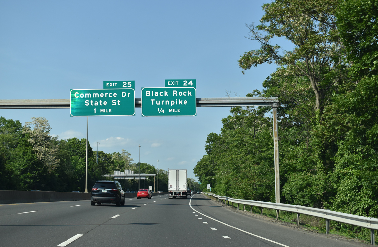
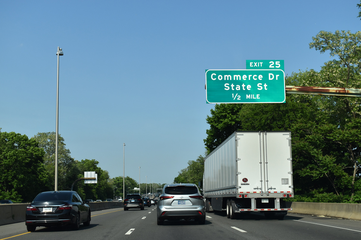
| Exit 25 departs Interstate 95 onto Coolidge Street at Commerce Drive. Governor John Lodge Turnpike enters the city of Bridgeport at the Roosler River. 05/30/22 |
|
| Commerce Drive parallels I-95 from Kings Highway east 0.74 miles to Exit 25 and the Roosler River. Upon entering the city of Bridgeport, Commerce Drive becomes State Street east 0.42 miles to Route 130 (Fairfield Avenue). 05/30/22 |
|
| I-95 elevates across State Street, AMTRAK and Route 130 along a stretch of freeway rebuilt in 2004-05. Continuing east, I-95 north lowers ahead of the diamond interchange (Exit 26) with Wordin Avenue, the first of five exits serving the city of Bridgeport. 05/30/22 |
|
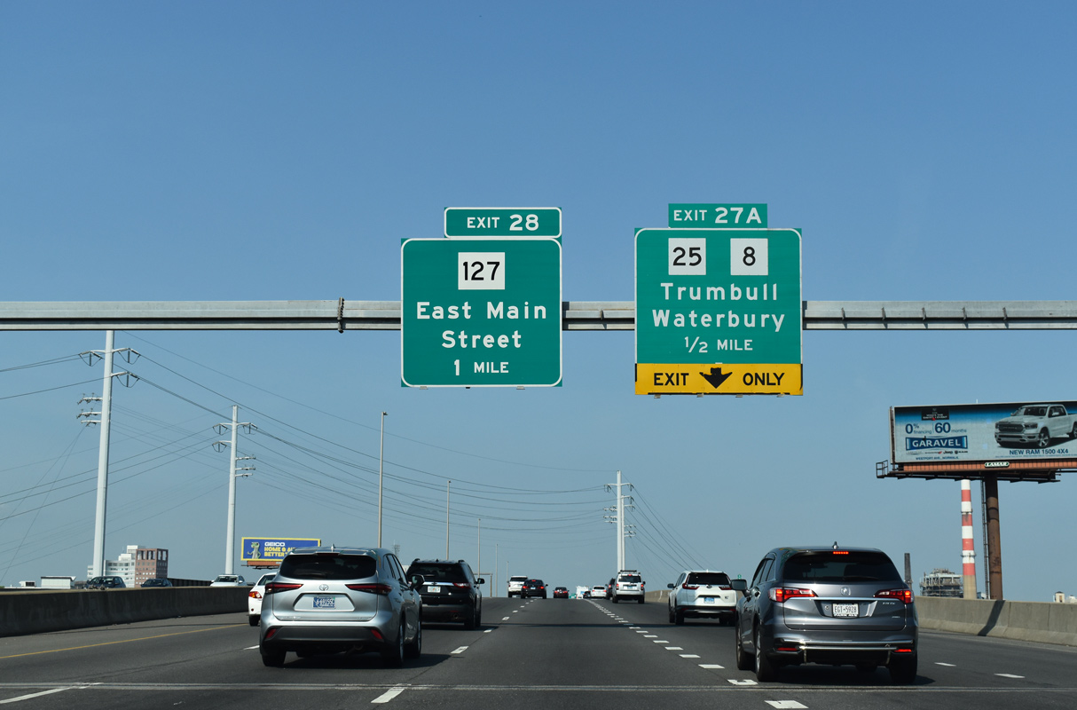
| Beyond Wordin Avenue, Governor John Lodge Turnpike again elevates onto a viaduct to the trumpet interchange (Exit 27 A) with Route 8/25 north. 05/30/22 |
|
| Wordin Avenue arcs 0.72 miles northeast from Hancock Avenue to Railroad Avenue and Route 130 (State Street). Parallel Route 130 travels 8.21 miles east from U.S. 1 at Fairfield to U.S. 1 at Stratford. 05/30/22 |
|
| The exchange with Route 8/25 north falls within the split diamond interchange at Exit 27. 05/30/22 |
|
| Exit 27 joins S Frontage Road between Myrtle Avenue, Warren Street and Lafayette Street south of Downtown Bridgeport. The Bridgeport & Port Jefferson Steamboat Company ferry terminal, which offers ferry service to Long Island, is to the east. 05/30/22 |
|
| Route 8/25 overlap along a freeway 3.75 miles north from the Bridgeport central business district to Exit 6 in north Bridgeport. Route 25 branches northwest from there to Trumbell and Newtown while Roue 8 continues north along a freeway to Shelton, Waterbury, Torrington and Winsted. 05/30/22 |
|
| Interstate 95 north continues across the Pequonnock River to Exit 28 with Route 127 (E Main Street). Route 127 runs 6.80 miles north from Route 130 (Stratford Avenue) to East Bridgeport and Route 111 by Trumbull Town Hall. 05/30/22 |
|
| Exit 28 lowers from I-95 north to Route 127 (E Main Street) at Bass Pro Drive, just north of Route 130 (Stratford Avenue). 05/30/22 |
|
| Looking south from Interstate 95 across the Pequonnock River at Bridgeport Harbor and Pleasure Beach. 07/27/07 |
|
| The parclo interchange (Exit 29) with Seaview Avenue to Route 130 (Stratford Avenue) spreads east from the bridge taking I-95 over Yellow Mill Channel. Route 130 separates into a couplet along Stratford Avenue east and Connecticut Avenue west between Seaview Avenue and Route 113 (Main Street) in Stratford. 05/30/22 |
|
| The succeeding exit from I-95 northbound connects with Route 113 (Lordship Boulevard), a loop southeast around Igor I. Sikorsky Memorial Airport (BDR). 05/30/22 |
|
| 8.12 miles long, Route 113 commences south from Exit 30. Almost entirely wihtin the town of Stratford, Route 113 returns north along Main Street to Route 110 (E Main Street). 05/30/22 |
|
| The split diamond interchange at Exit 30 joins I-95 with Lordship Boulevard / Hollister Avenue (Route 113) and Surf Avenue at the Bridgeport / Stratford town line. 05/30/22 |
|
| Route 113 angles southeast along Lordship Boulevard to the community of Lordship along Long Island Sound. Surf Avenue angles 0.93 miles northeast from Lordship Boulevard to Route 130 (Stratford Avenue) along St. Michael's Cemetery. 05/30/22 |
|
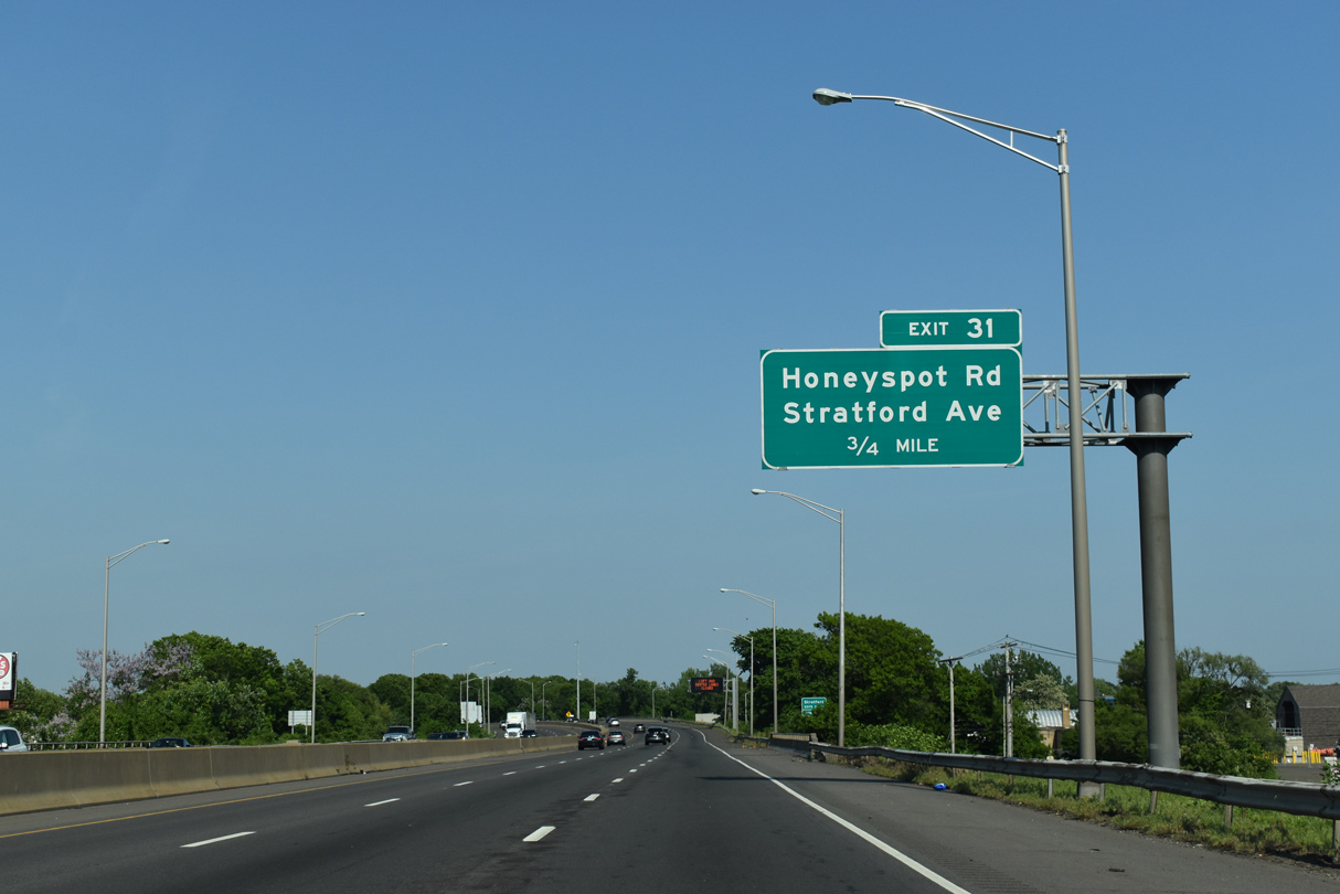
| Forthcoming Honeyspot Road heads 1.15 miles northeast from an industrial area along Route 113 (Lordship Boulevard) to Route 130 (Straford Avenue) at South Avenue. 05/30/22 |
|
| Interstate 95 reassurance marker posted beyond the entrance ramp from Surf Avenue. 05/30/22 |
|
| Exit 31 is a split diamond interchange with Mount Carmel Boulevard east and Spada Boulevard west linking Honeyspot Road and South Avenue. 05/30/22 |
|
| Honeyspot Road south and South Avenue east serve residential areas of south Stratford. Route 130 (Stratford Avenue) passes under I-95 to the northeast. 05/30/22 |
|
| Advancing northeast, I-95 next meets Bearsley Avenue and W Broad Street at Exit 32 near the Statford town center. 05/30/22 |
|
| The modified diamond interchange at Exit 32 links I-95 northbound with a rotary joining Beardsley Avenue south and W Broad Street just west of Route 113 (Main Street) and the Stratford Center Historic District. 05/30/22 |
|
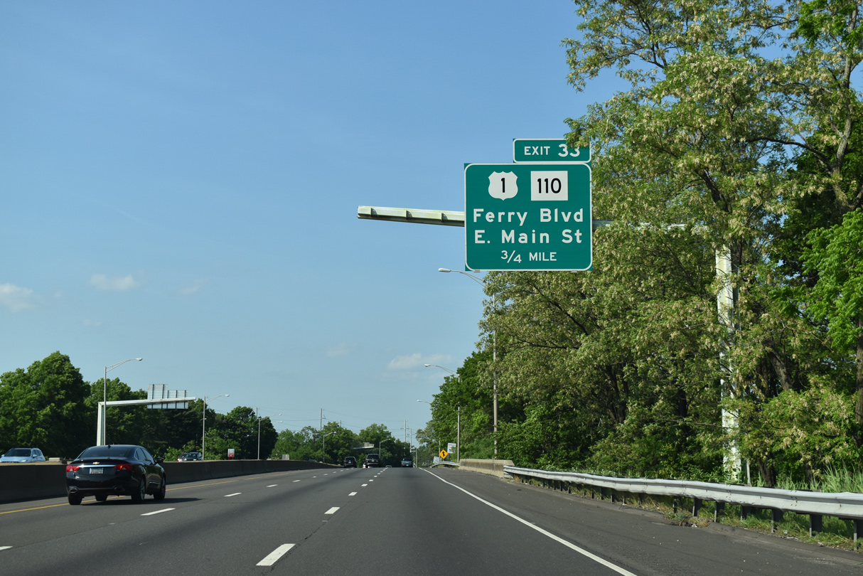
| U.S. 1 (Barnum Avenue Cutoff) returns to Interstate 95 at Route 130 (Ferry Boulevard) and Route 110 (E Main Street) just west of the Housatonic River. 05/30/22 |
|
| Interstate 95 north spans Church Street and Route 113 (Main Street) beyond this confirming marker. 05/30/22 |
|
| The diamond interchange at Exit 32 connects I-95 north with U.S. 1 (Ferry Boulevard) east ahead of Route 110 (E Main Street). Route 110 follows the Housatonic River north to Shelton along a 15.94 mile course to Route 111 at Monroe. 05/30/22 |
|
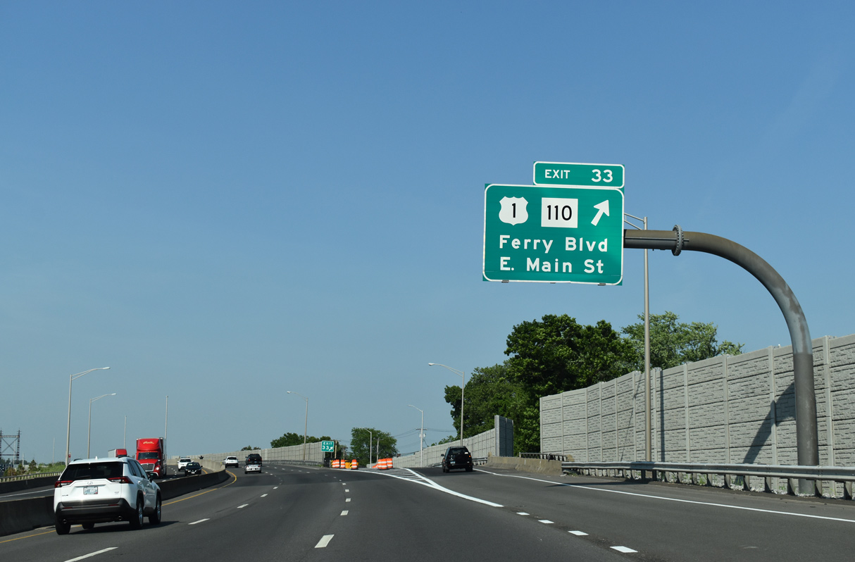
| U.S. 1 (Ferry Boulevard) crosses the Washington Bridge east from Exit 33 and Route 110 (E Main Street) to the Devon community in the city of Milford. into Devon east of Stratford. 05/30/22 |
|
| I-95 crosses the Housatonic River on the Moses Wheeler Bridge adjacent to the AMTRAK Northeast Corridor. Continuing into New Haven County and the city of Milford, Exit 34 follows to adjacent U.S. 1 (Bridgeport Avenue). 05/30/22 |
|
| A trumpet interchange and access road links Interstate 95 with U.S. 1 (Bridgeport Avenue)at Exit 34. Sound walls were added here during the 2009-17 Moses Wheeler Bridge replacement project. 05/30/22 |
|
| U.S. 1 (Bridgeport Avenue) heads west to Rivercliff and Devon in Milford. U.S. 1 east remains south of Interstate 95 to Exit 39 north of Downtown Milford. 05/30/22 |
|
| Schoolhouse Road north and Sub Way south come together at a diamond interchange (Exit 35) with Interstate 95 in a quarter mile. 05/30/22 |
|
| Interstate 95 spans the AMTRAK Northeast Corridor adjacent to Milford Reservoir. 05/30/22 |
|
| Schoolhouse Road heads 0.41 miles east from I-95 to U.S. 1 (Bridgeport Avenue) north of Silver Sands State Park. Sub Way runs north by the Naugatuck Gardens neighborhood onto Bic Drive at Naugatuck Avenue. 05/30/22 |
|
| Plains Road meets Interstate 95 at the ensuing exit near Lily Pond and U.S. 1 (Boston Post Road). 05/30/22 |
|
| Clark Street branches south from Plains Road nearby to Route 162 (Bridgeport Avenue). Comprising a 10.34 mile long loop to U.S. 1 in Orange, Route 162 continues Bridgeport Avenue east from U.S. 1 through Milford center. 05/30/22 |
|
| Interstate 95 traverses wetland areas along Beaver Brook and at Dismal Swamp between Exits 35 and 36. 05/30/22 |
|
| Interstate 95 north at the diamond interchange (Exit 36) with Plains Road. 05/30/22 |
|
| High Street heads northwest from Route 162 (Broad Street) in central Milford to Interstate 95 at Zion Hill Road. Milford Parkway (Route 796) is a 1.78 mile long limited access connector north to Route 15 (Merritt Parkway / Wilbur Cross Parkway). 05/30/22 |
|
| A single exit ramp links I-95 north with High Street adjacent to the half cloverleaf interchange (Exit 38) with Milford Parkway (Route 796). 05/30/22 |
|
| Route 15 follows Merritt Parkway west from Milford to the New York state line at Hutchinson River Parkway. Route 15 continues northeast along Wilbur Cross Parkway to Hamden and Meriden. 05/30/22 |
|
| Zion Hill Road connects High Street with Wheelers Farm Road north 2.78 miles into the town of Orange near Turkey Hill. 05/30/22 |
|
| Like the parkways in New York City, Route 15 along Merritt and Wilbur Cross Parkways is restricted to passenger vehicles only. 05/30/22 |
|
| Interstate 95 arcs east from Milford Parkway across the Wepawaug River and Route 121 (North Street). 05/30/22 |
|
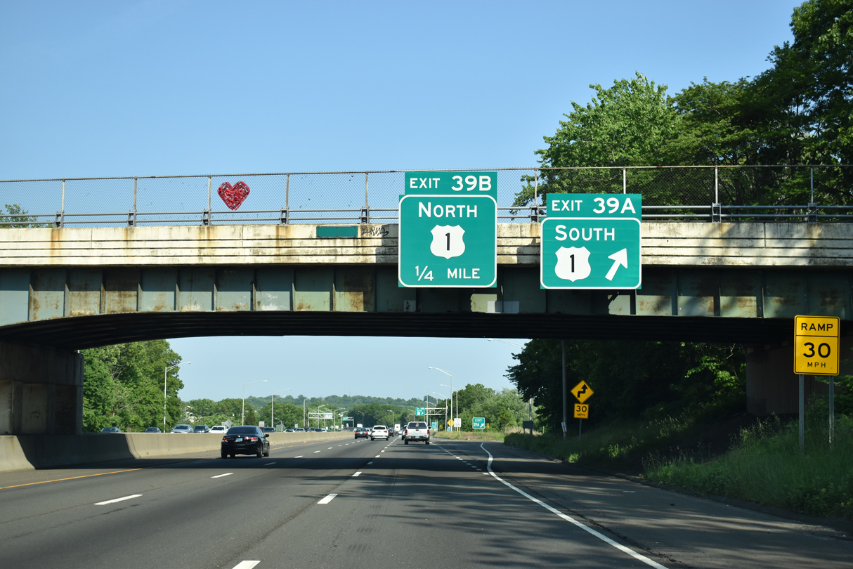
| U.S. 1 converges with Interstate 95 again at a cloverleaf interchange (Exit 39). 05/30/22 |
|
| Exit 39 A departs next for U.S. 1 (Boston Post Road) south to Downtown Milford. 05/30/22 |
|
| U.S. 1 (Boston Post Road) leads west 0.7 miles from Exit 39 A at Home Acres Avenue to Route 121 (North Street). Route 121 runs 5.66 miles north from Milford to Route 34 (Derby Turnpike) along the Derby city and Orange town line. 05/30/22 |
|
| Exit 39 A ties into U.S. 1 (Boston Post Road) at Home Acres Avenue, adjacent to the separation with Cherry Street to Downtown Milford. Home Acres Avenue spurs 0.47 miles southeast to the Indian River. 05/30/22 |
|
| Spanning I-95 north at Exit 39 A, Forest Road stems north from Locust Street and U.S. 1 (Boston Post Road) to the Forest Heights community. 05/30/22 |
|
| U.S. 1 shifts north of Interstate 95 from Exit 39 B to Connecticut Post Mall, the town of Orange and the city of West Haven. 05/30/22 |
Page Updated 03-13-2023.

 North
North