|
| Removed by 2012, the first confirming marker for Interstate 205 appeared by the gore point for Exit 7 along I-5 south. 09/02/06 |
|
| Exit 36 departs I-205 south for NE 134th Street to serve the Salmon Creek and WSU Vancouver area just beyond the wye interchange with I-5. Exit 36 links with NE 134th Street at NE Highway 99, a connector to old U.S. 99/830. 09/02/06 |
|
| Angling southeast between Salmon Creek and Mt. Vista, Interstate 205 continues nine miles from the NE 119th Street overpass to SR 14 (Lewis and Clark Highway), the final exit in Washington. Salem is used as the southbound control city for the continuation of I-5 beyond Portland. 09/02/06 |
|
| Padden Parkway connects with Interstate 205 east of NE Anderson Road at Exit 32. The arterial travels east from NE 78th Street at Walnut Grove to become SR 500 north of Orchards. 09/02/06 |
|
| Exit 32 is six-ramp parclo interchange with a single off-ramp southbound from I-205 to NE Padden Parkway. Nearby NE Anderson Road travels north to Barberton and south to Minnehaha. 09/02/06 |
|
| SR 500 combines with SR 503 (NE 117th Avenue) south one mile from Padden Parkway to an expressway leading to Interstate 205 at Exit 30. 09/02/06 |
|
| Confirming marker posted south of the NE 78th Street overpass by the census designated place of Five Corners. 09/02/06 |
|
| NE 63rd Street crosses I-205 a half mile north of the cloverleaf interchange (Exit 30) with SR 500 in north Vancouver. SR 500 comprises a limited access expressway west to I-5 and east to Fourth Plain Boulevard. 09/02/06 |
|
| A c/d roadway separates from Interstate 205 south for SR 500 and NE Fourth Plain Boulevard at Vancouver Mall Drive. 09/02/06 |
|
| Passing south of Minnehaha, SR 500 ties into Interstate 5 south toward the Vancouver city center five miles to the west. 09/02/06 |
|
| The exit for SR 500 partitions with a ramp for Vancouver Mall Drive west at NE Fourth Plain Boulevard (former SR 500). 09/02/06 |
|
| Measuring 22.18 miles in length, SR 500 travels from Vancouver east and south to SR 14 at Camas. 09/02/06 |
|
| Reassurance marker posted one mile north of Exit 28 to Mill Plain Boulevard. 09/02/06 |
|
| Interstate 205 advances seven miles south to I-84/U.S. 30 in Portland and 21 miles to the western turn at Oregon City. 09/02/06 |
|
| Mill Plain Boulevard meets Interstate 205 at a six-ramp parclo interchange (Exit 28) in 0.75 miles. 09/02/06 |
|
| Mill Plain Boulevard runs across Vancouver west to the I-5 by the city center and through suburban areas east to SE 192nd Avenue. 09/02/06 |
|
| SR 14, a 180.68 mile long highway stretching east from Vancouver to I-82/U.S. 395 at Plymouth, is the succeeding exit on Interstate 205 south. 09/02/06 |
|
| Directional ramps at Exit 27 connect I-205 south with the freeway along SR 14 (Lewis and Clark Highway). 09/02/06 |
|
| SR 14 replaced the entire length of U.S. 830 in 1968. The freeway west to I-5 at the city center from Ellsworth and Fisher in east Vancouver was already opened at that time. 09/02/06 |
|
| A flyover leads to SR 14 eastbound from Interstate 205 south. SR 14 travels eight miles to Camas and ten miles to Washougal along the Columbia River. 09/02/06 |
|
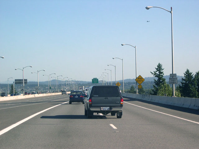
| Interstate 205 spans the main channel along the Columbia River over the Glenn L. Jackson Bridge. Named after a former chairman of the Oregon Transportation Commission, the bridge provided a much needed crossing of the Columbia in the east Portland metro area when it opened in 1982. 07/21/05 |
|
| Continuing south into Oregon, Interstate 205 next meets Airport Way at Exit 24. 09/02/06 |
|
| I-205 enters the Beaver State a short distance south across the Columbia River. A bike path runs between the two directions of traffic on the Glen L. Jackson Memorial Bridge. 09/02/06 |
Page Updated 11-16-2010.

 South
South