
 West
West
A diamond interchange (Exit 19) with ProMedica Parkway replaced the exit ramp from I-475 west to Jackman Road.
09/02/05

ProMedica Parkway weaves southward from Upton Avenue and Exit 19 to SR 120 (Central Avenue) and ProMedica Toledo Hospital.
09/02/05

SR 120 (Central Parkway) continues west from ProMedica Parkway to the village of Ottawa Hills and I-475 again alongside U.S. 20 at Exit 13.
09/02/05

09/02/05

A half diamond interchange joins I-475 west with Douglas Road at Exit 18B.
09/02/05

09/02/05

09/02/05

Meeting Interstate 475 at Exit 18A, SR 51 (Monroe Street) angles northwest from Toledo to U.S. 23/223 at Sylvania.
09/02/05

Secor Road heads north from the University of Toledo to a commercialized diamond interchange with Interstate 475 at Exit 17.
09/01/05

Secor Road continues 2.3 miles north to SR 184 (Alexis Road) and 4.3 miles to Lambertville, Michigan.
09/02/05

09/02/05

Exit 16 departs I-475 west a half mile beyond the Woodley Road overpass for Talmadge Road north to Franklin Park Mall.
09/02/05

Talmadge Road south leads to SR 120 (Central Avenue) at the village of Ottawa Hills. SR 120 continues west to Wildwood Preserve Metropark.
09/02/05

U.S. 23 converges with Interstate 475 south from Sylvania at a directional T interchange (Exit 14).
09/02/05

Interstate 475 crosses the Ottawa River north of Wildwood Preserve Metropark.
09/02/05

U.S. 23 constitutes a freeway extending north from Toledo to Ann Arbor and Interstate 75 near Flint, Michigan.
09/02/05

Interstate 475 and U.S. 23 overlap southward from Exit 14 to Perrysburg. U.S. 23 north accompanies U.S. 223 from Sylvania to Whiteford Township, Michigan.
09/02/05

U.S. 23 travels 38 miles north to I-94 at Ann Arbor and 93 miles to the overlap with I-75.
09/02/05
 South
South
The folded diamond interchange joining I-475/U.S. 23 south with U.S. 20/SR 120 at Exit 13 was converted to a SPUI as part of the expansion of Interstate 475.
09/02/05

U.S. 20 combines with SR 120 (Central Avenue) 1.1 miles east of Exit 13. The two routes overlap west 11.3 miles from I-475/U.S. 23 to SR 64 at Assumption.
09/02/05

09/02/05
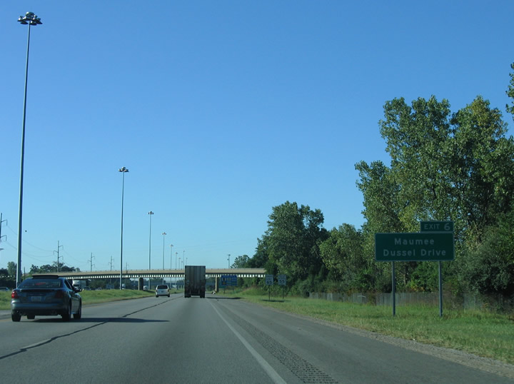
I-475/U.S. 23 straddle the Maumee city line south from the Ohio Turnpike to the six-ramp parclo interchange (Exit 6) with Dussel Drive.
09/02/05

I-475/U.S. 23 cross over the Ohio Turnpike at Swan Creek without direct access. Dussel Drive east to U.S. 20 provides a Breezewood connection to I-80/90.
09/02/05

09/02/05

09/02/05

A cloverleaf interchange (Exit 4) joins I-475/U.S. 23 with U.S. 24 (Anthony Wayne Trail) in southwest Maumee.
09/02/05

09/02/05

U.S. 24 is the Fort to Port Corridor, a controlled access expressway west from the Toledo area to Interstate 469 at Fort Wayne, Indiana.
09/02/05

U.S. 24 bypasses Waterville to the west en route to Napoleon in 28 miles and Defiance in 42 miles.
09/02/05

09/02/05

I-475/U.S. 23 curve southeast across the Maumee River, the dividing line between Lucas and Wood County.
09/02/05

The lone exit for the city of Perrysburg along I-475/U.S. 23 south is the DDI with SR 25 (N Dixie Highway).
09/02/05

Following old U.S. 25, SR 25 parallels I-75 to the west south from Perrysburg to Bowling Green and Portage.
09/02/05

Interstate 75 to U.S. 68 south and SR 15 east at Findlay provides a direct route to the continuation of U.S. 23 south from Carey to Columbus.
09/02/05
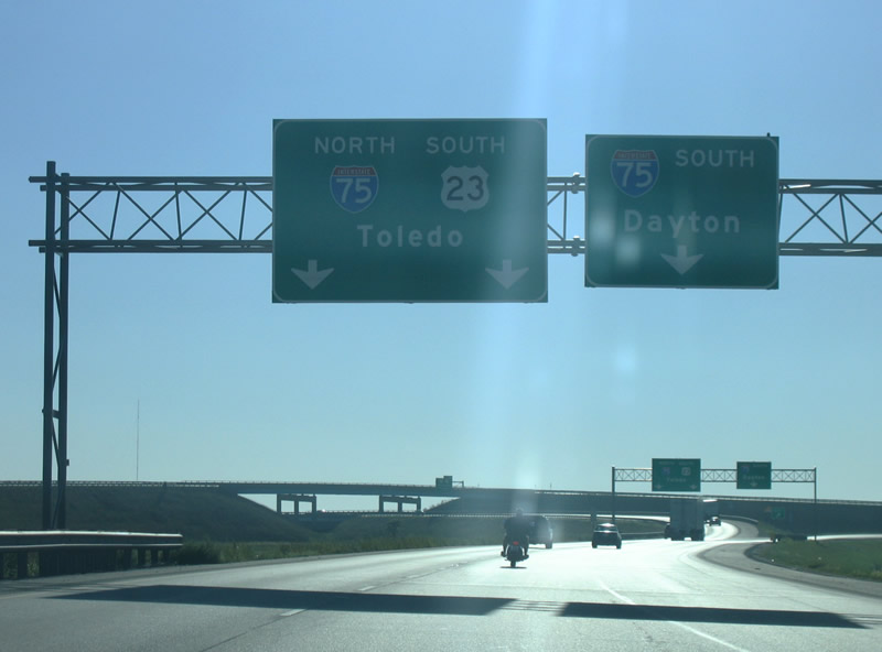
U.S. 23 joins I-75 north to the succeeding exit in Perrysburg. I-75 south travels 137 miles to Dayton.
09/02/05

U.S. 23 branches east from I-75 along an 11.1 mile overlap with U.S. 20. Interstate 75 reaches Downtown Toledo in 9.5 miles.
09/02/05
Photo Credits:
09/01/05, 09/02/05 by AARoads
Connect with:
Interstate 75
U.S. 20
U.S. 23
U.S. 24
State Route 2
State Route 51
Page Updated 08-06-2021.