
Day 2 – Seymour, Indiana to Petoskey, Michigan
Heading north from southern Indiana to the capital city, Interstate 65 continues with four lanes and loads of tractor trailers. The constant beating the pavement takes from the moving freight prompted officials to resurface the route from Whiteland to Greenwood in 2007 as part of the INDOT Major Moves initiative. Expansion of the road to six lanes does not occur until Exit 99.
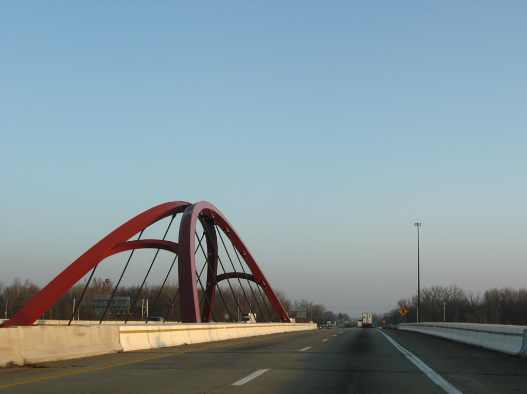
Interstate 65’s diamond interchange with Indiana 46 was upgraded to a single point urban interchange. In addition to the ramp reconfiguration, decorative arches were added to the Interstate 65 bridges over the state road.
Once in the downtown Indianapolis area, Interstate 65 briefly joins with Interstate 70 on the east side of the central business district. This stretch was rehabilitated in 2003 as part of the “Hyperfix 65/70” project by INDOT. 33 bridge decks and 35 lane miles of concrete were repaired to go along with capacity improvements as part of a $30-million project. This stretch opened in 1976.
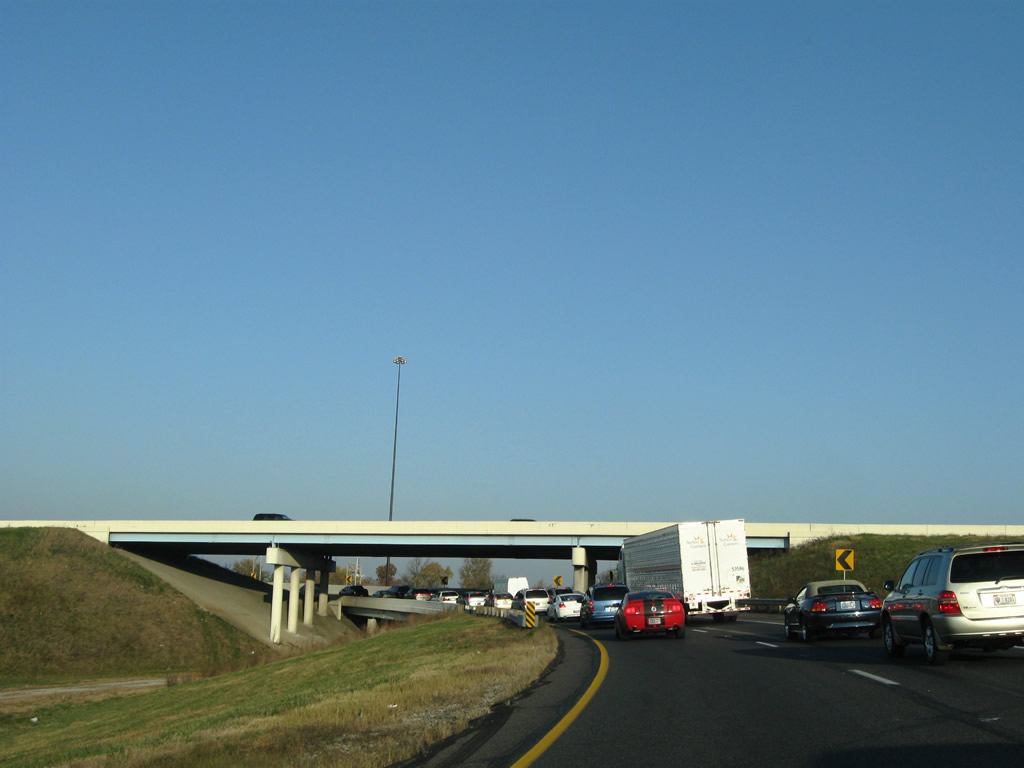
Morning traffic slows toward the Exit 113 split-diamond interchange, the main access point into downtown Indianapolis from Interstate 65 north. Pictured here are stacked ramps built at the split with Interstate 70 over a ghost ramp that was intended to join the freeways with unconstructed Interstate 69.
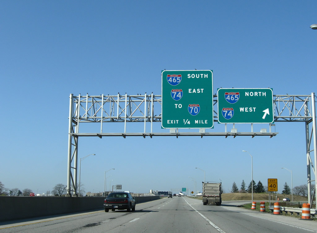
Encircling the city is Interstate 465, Indianapolis’ beltway and a myriad of vastly unsigned overlaps. They include U.S. 31, 36, 40, 52, 421, and Indiana 37 & 67. Construction is underway on two projects involving the 53-mile loop. The first is emergency work to repair a bridge at the Interstate 69 interchange that was damaged when a propane truck exploded in late October. The freeway was briefly closed in both directions so crews could assess the damage and make emergency repairs. Work currently shifts the westbound direction above the I-69 southbound on-ramp as crews finish repairs. Additional work along Interstate 465 was completed in 2008 involving pavement rehabilitation from Fall Creek to Interstate 74, joining other recently completed work focused on widening of Interstate 465 between the split with Interstate 74 west and 56th Street. The $74.8-million work included the upgrading of the 38th Street interchange. Construction on this stretch, one of the oldest of the beltway, was completed between 2007 and 2009. Accelerate 465 http://www.in.gov/indot/div/projects/accelerate465/design/features.html entails Interstate 465 southward from Interstate 74 to Interstate 70 on the southwest side of Indianapolis. Upgrading of the freeway will result in 12 foot travel lanes, a 30 foot paved median with jersey barrier within a minimum 216 foot right of way. Interchange improvements are included. At Interstate 74 / Crawfordville Road (U.S. 136), new ramps will join U.S. 136 with both freeways (currently not a direct movement). High speed flyover ramps will be added to the interchange with Interstates 74 and 465 and eliminate some of the loop ramps and associated weaving traffic movements. Work also will upgrade interchanges with West 10th Street, U.S. 36 (Rockville Road), U.S. 40 (Washington Street), the Sam Jones Expressway, and Interstate 70. The Interstate 70 work will replace the eastbound to northbound loop ramp with a 40-mph design speed flyover. Shifting to the west and a revisit to Interstate 70, construction is complete on both the freeway widening and the new airport interchange and terminal. Interstate 70 includes a long collector/distributor roadway system connecting Interstates 74 & 465 with Ronald Reagan Parkway and Ameriplex Parkway. Indianapolis International Airport constructed its new Colonel H. Weir Cook Terminal on the west side of the airport. A new access road and directional interchange was added from Interstate 70 in the process. The old terminal, located at the west end of the Airport Expressway (since renamed to the Sam Jones Expressway), remains unused at this time.
Sam Jones Expressway westbound at the directional-cloverleaf interchange with Interstates 74 & 465. Upgrading of this interchange entails improving capacity to the southbound to eastbound ramp to two lanes and the addition of c/d roadways to eliminate some of the weaving traffic concerns.
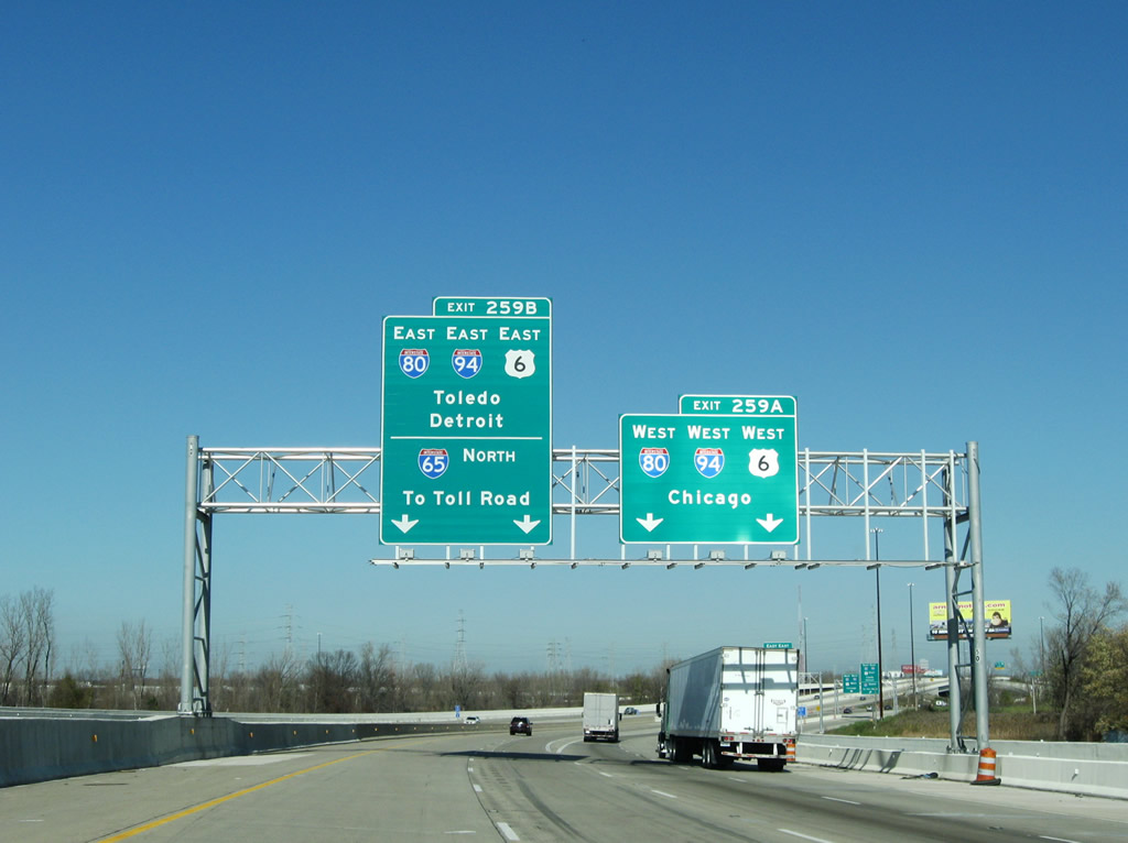
Further north, ramp grading is underway involving the building of a new diamond interchange with East 109th Avenue near the city of Crown Point at milepost 250. Another Major Moves initiative focuses on the reconstruction of the Interstate 65 interchange with Interstates 80 & 94 at Gary. A new collector/distributor roadway was added to the northbound side of Interstate 65 from Ridge Avenue (U.S. 6 Business) to the Northwest Connector. Additionally a new two-lane flyover carries drivers from Interstates 80 & 94 west onto Interstate 65 south.
A slip ramp facilitates the movements from Interstate 65 north onto the adjacent c/d roadway emanating from Exit 258 for the Northwest Connector to Interstates 80 & 94 west.
Once in Michigan, we encountered an unbelievable amount of construction. Many of these projects are related to the American Recovery and Reinvestment Act (ARRA) and involved pavement and shoulder rehabilitation. Although displayed as under construction on many maps, there was no work evident involving the completion of the U.S. 31 freeway between Napier Avenue and the Interstate 94/196 split. The Record of Decision for this project was issued on August 31, 2004. Drivers between the U.S. 31 stub end and Interstate 94 must utilize Napier Avenue to make the connection.
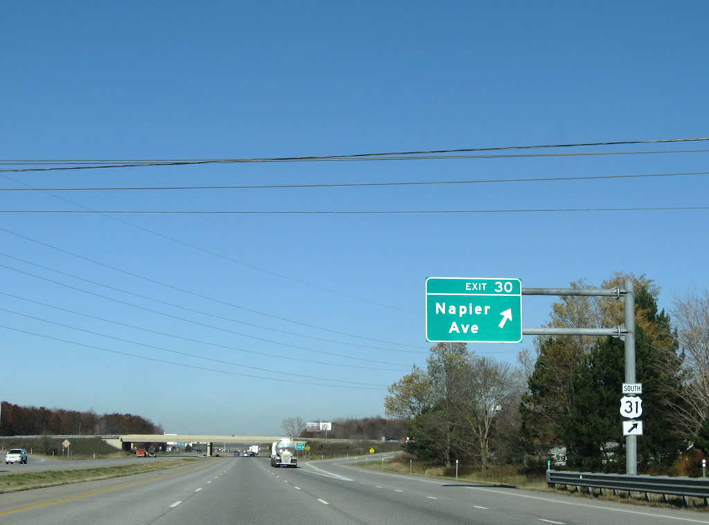
Signage only haphazardly mentions the U.S. 31 connection from Interstate 94 east to its freeway leading south from Napier Avenue.
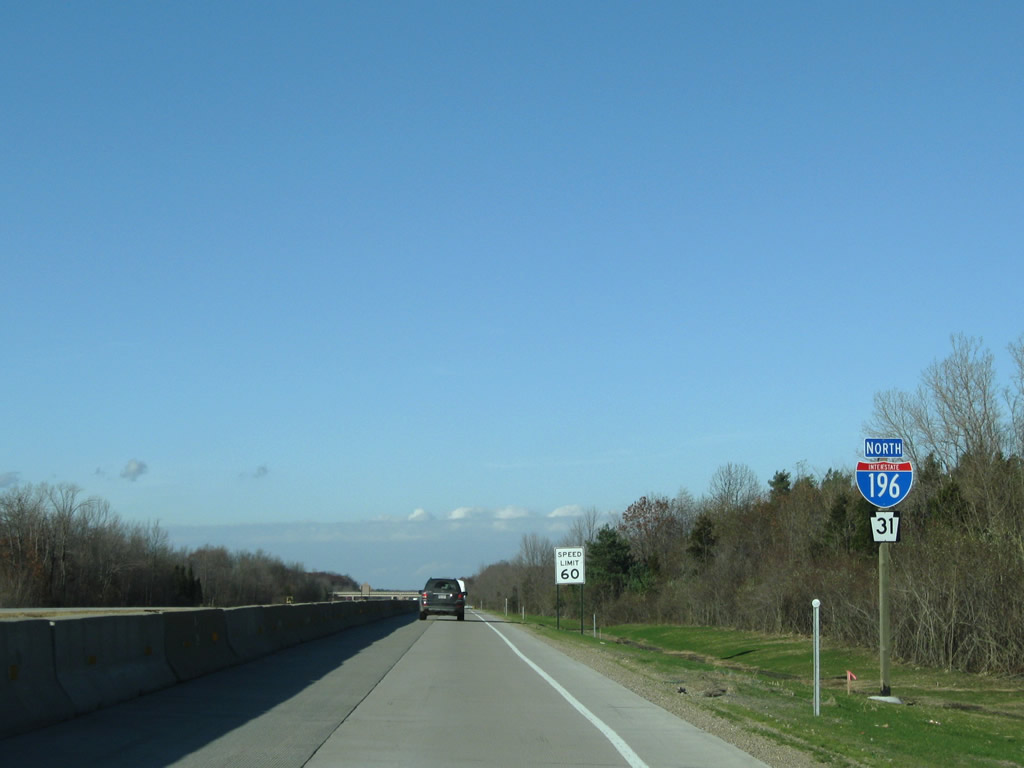
One of the many ARRA projects in Michigan focuses on the rehabilitation of Interstate 196 & U.S. 31 north between Exits 22 and 30 in Allegan County. Rehabilitation of the concrete surface is underway to go along with a complete resigning of all shields and exit signs. Included with the Clearview signs are two infamous error assemblies displaying U.S. 31 as Pennsylvania 31! Work also focuses on rehabilitating Interstate 196 from the split with M-6 east to Exit 70 (M-11) and again in downtown Grand Rapids.
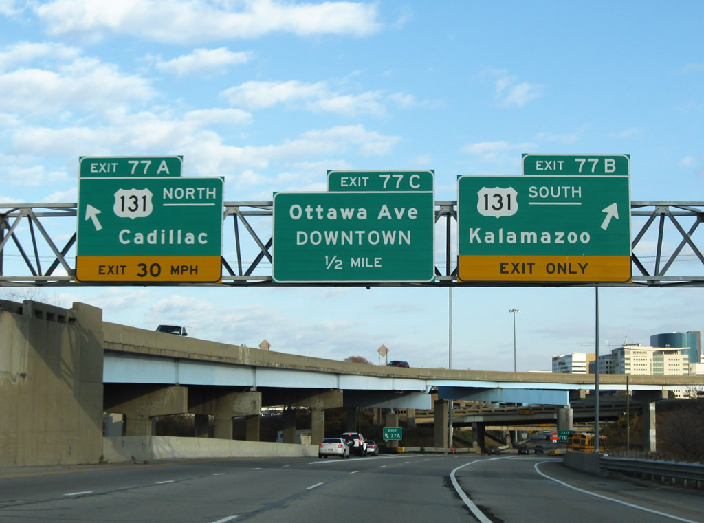
Interstate 196 eastbound at the U.S. 131 stack interchange at downtown Grand Rapids.
U.S. 131 doubles as hidden Interstate 296 northward to Interstate 96. The designation was signed from 1963 to 1980 according to the official Michigan highway map. Its removal was likely due to redundancy with the longer U.S. 131 routing.
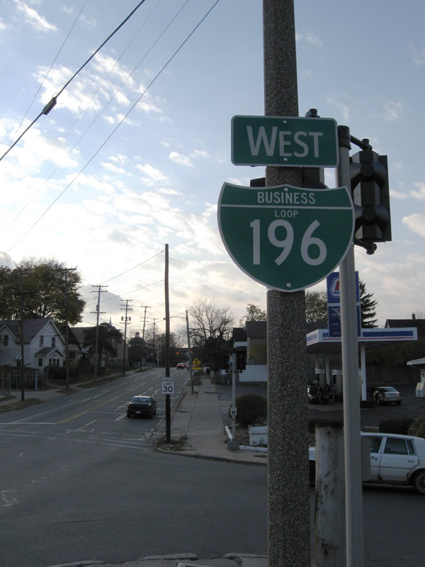
Interstate 196 switches from north/south cardinal directions to east/west at its split with U.S. 31 in Holland.
What is supposed to be signed as Business Spur Interstate 196 was signed as Business Loop on all signage at the U.S. 131 interchange with Franklin Street (Exit 83B). The spur travels west 4.15 miles to Exit 72 of Interstate 196.
And much further north, .S. 131 is completely closed at the Manistee River in Wexford County. MDOT is replacing the 1950s-era bridge and the entire freeway is blocked at the M-42 folded-diamond interchange http://www.michigan.gov/mdot/0,1607,7-151–221112–,00.html. Ridiculously long detours are in place at the last three interchanges of the U.S. 131 freeway directing motorists to M-66 north. Additionally for drivers leading north from Manton, U.S. 131 Business sees signs “Bridge out 7 miles ahead”. Additional Sources:
- http://www.in.gov/indot/2547.htm
- Hyperfix 65/70: Indiana closed a major interstate corridor for repairs and reopened it a month ahead of schedule.
http://findarticles.com/p/articles/mi_m3724/is_5_67/ai_n6127045/ - I-69 SB ramp to I-465 SB site of tanker explosion (AARoads Forum).
- Interstate 465 (INDOT).
http://www.in.gov/indot/2534.htm - INDOT Awards Contracts For I-465 Project.
http://www.insideindianabusiness.com/newsitem.asp?ID=24187 - US-31 freeway completion in Michigan.
Thank you for taking the time to post this.