
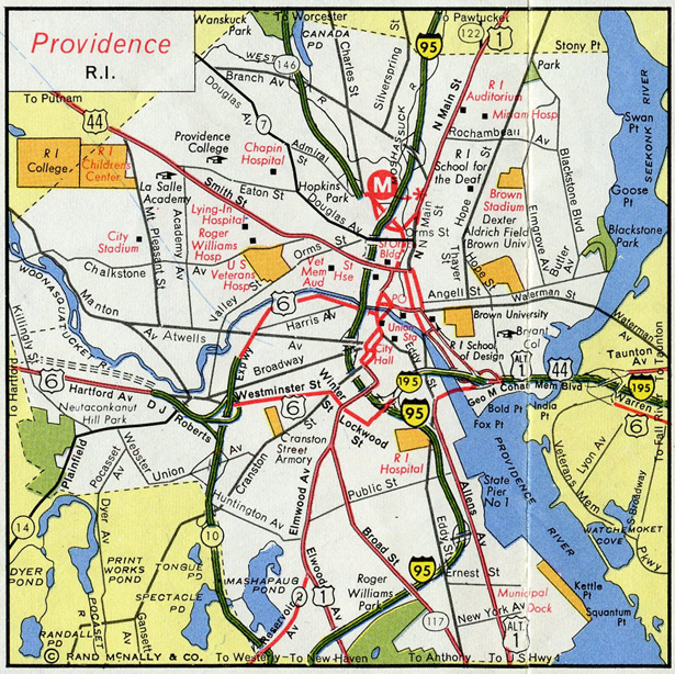
U.S. 6

U.S. 6 crosses the state of Rhode Island from rural areas in the town of Foster to urban areas of East Providence. Alternating passing lanes expand U.S. 6 along the two lane stretch through Scituate. U.S. 6 follows the Dennis J. Roberts Expressway between I-295 in Johnston and Route 10 in Providence, and the Huntington Expressway with Route 10 northeast to Interstate 95 at Downtown Providence. The remainder of U.S. 6 in the Ocean State overlaps with I-95 and I-195 from Providence to Seekonk, Massachusetts.
First envisioned in a 1945 freeway plan for metropolitan Providence, the limited access highway between Route 10 and Interstate 295 was planned in the 1950s with completion envisioned by 1968. However with focus on I-95 and I-195 instead, work on the freeway did not gain momentum until 1968. The Dennis J. Roberts Expressway opened in 1971 and was designated Route 195 in anticipation of the proposed Interstate 84 extension from Connecticut. The freeway later became part of U.S. 6 in 1991.2
The partially completed Dennis J. Roberts Expressway across Providence in 1969.
Unconstructed Interstate 84
The states of Connecticut and Rhode Island first brought up the idea of a limited access highway linking their respective capital cities in 1944. Having gained enough support, the two states submitted the proposal for inclusion in the 1956 Interstate Highway System. Their proposal was denied. The Hartford to Providence Interstate again came up for approval in 1968 when the Bureau of Public Roads expanded the Interstate network by an additional 1,500 miles. With approval, the route was initially designated as Interstate 82, and shortly thereafter as I-84. Corresponding changes renumbered existing I-84 between Hartford and Sturbridge, Massachusetts as Interstate 86.2
Planning for the route involved construction of a freeway along the existing U.S. 6 roadway from Interstate 295 west to the Connecticut state line, and utilizing the freeways along both Route 10 (Huntington Expressway) and Route 195 (Dennis J. Roberts Expressway). The proposal also included designating Interstate 184 along the Huntington Expressway leading south to I-95 in Providence. West of Interstate 295, upgrading U.S. 6 to a freeway was selected instead of constructing a new facility in order to minimize impacts to the nearby Scituate Reservoir. However Environmental Impact studies conducted in 1975 were deemed insufficient for the route, and approval for I-84 was denied by 1979. Planning for Connecticut sections of Interstate 84 were preapproved but contingent upon Rhode Island building their section of the freeway.2
Therefore a new route was discussed that involved extending the freeway along Route 37 northwest from I-295 to the planned Interstate 84 route in Connecticut. Strong community opposition however quickly arose to this alignment, ultimately resulting in Rhode Island officials cancelling their section of Interstate 84 in 1982. Connecticut followed and withdrew its mileage for Interstate 84 by 1983.2
 East
East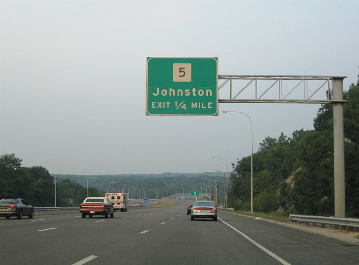
U.S. 6 leaves its briefly overlap with the Interstate 295 freeway on its own freeway toward Providence. The first interchange along the U.S. 6 freeway joins the route with Route 5 (Atwood Avenue) in east Johnston.
06/25/05
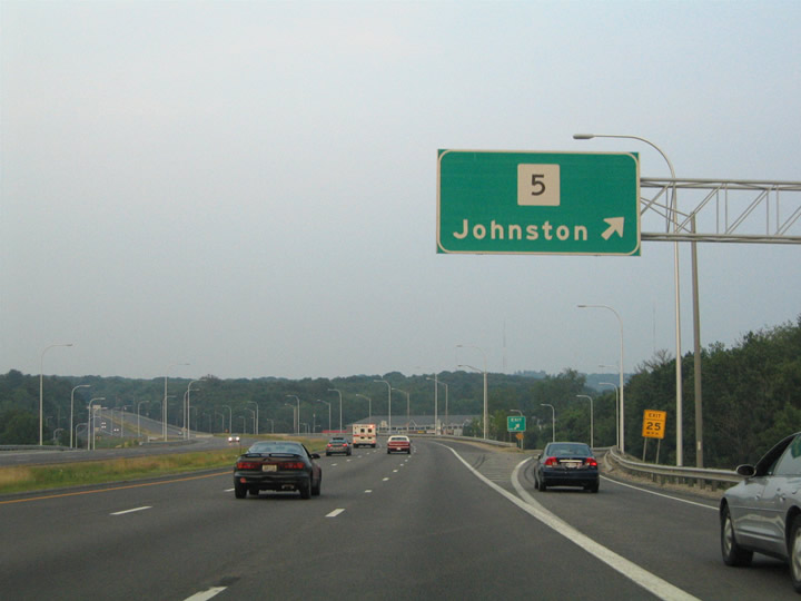
Eastbound at the ramp departure to Route 5 (Atwood Avenue) on U.S. 6. Route 5 travels in a north-south fashion through Thornton and Hughesdale nearby toward Greenville and Centerdale to the north. A diamond interchange joins the two highways.
06/25/05
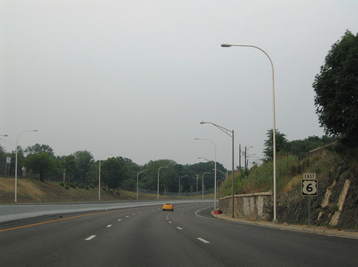
Amid a light replacement project, U.S. 6 continued east toward the city of Providence. A reassurance marker lies beyond the Route 5 off-ramp.
06/25/05
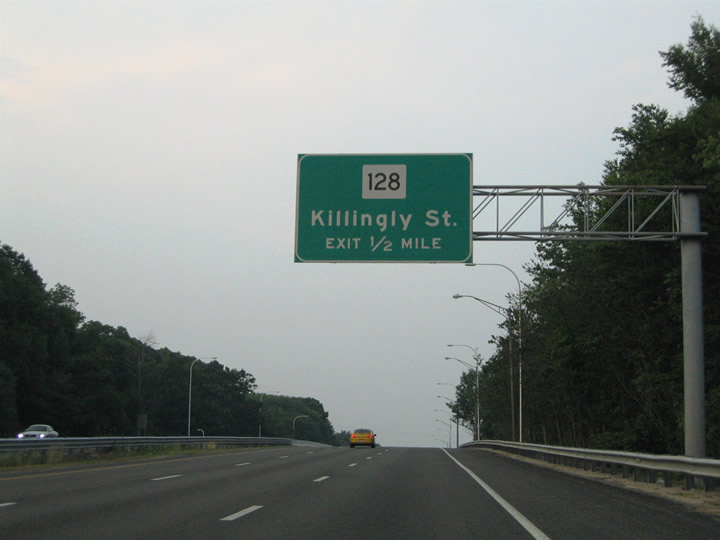
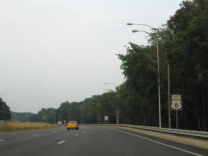
Route 128 (Killingly Street) intersects the U.S. 6 freeway at the Johnston town line with Providence. Killingly branches northwest from Route 14 (Plainfield Street) to Neutaconkanut Park and Greenville Avenue at Manton.
06/25/05
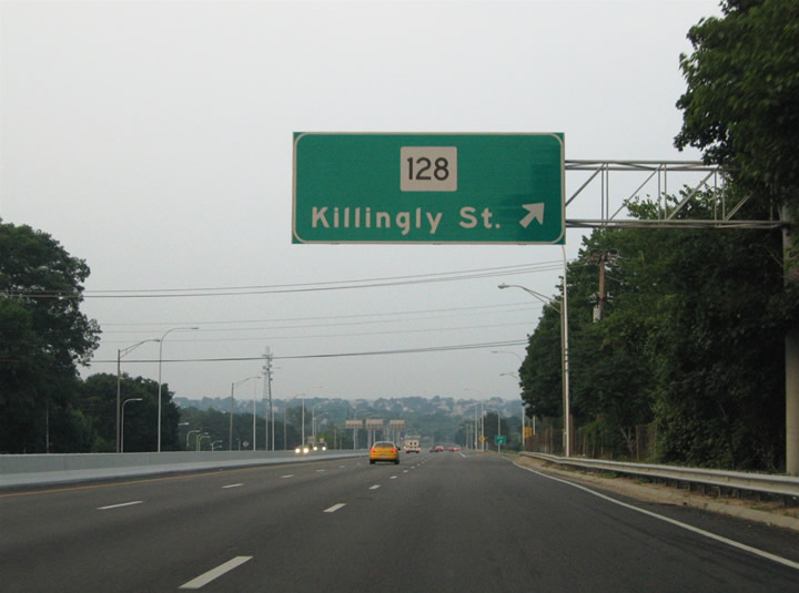
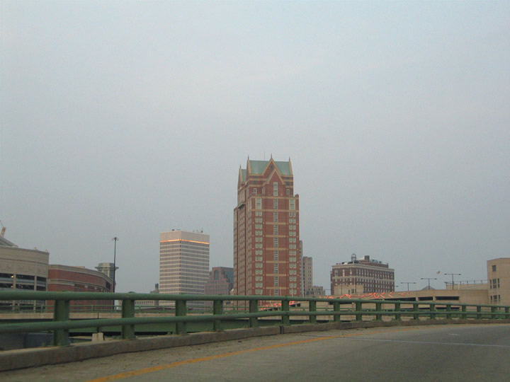
The cityscape of Providence lies along the eastern horizon as the U.S. 6 freeway enters the six-ramp parclo interchange with Route 128 (Killingly Street). Route 128 entails a 3.1 mile routing between U.S. 44 at Centerdale and U.S. 6A (Hartford Avenue) just south of U.S. 6.1
06/25/05
U.S. 6 enters the city of Providence between the Merino and Dyerville neighborhoods. Mancini Drive and Grimwood Street briefly act as frontage streets to the freeway here.
06/25/05
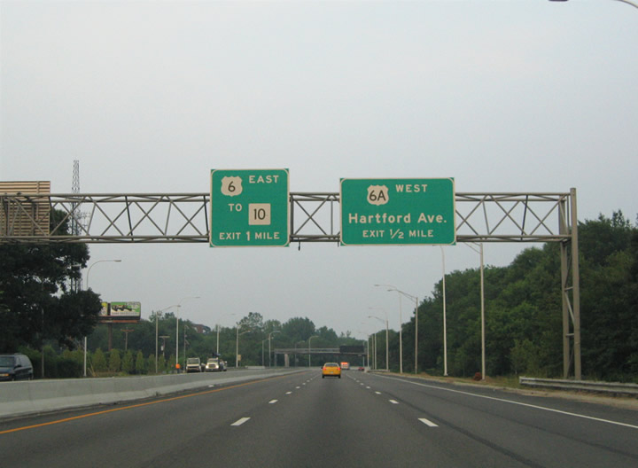
U.S. 6A (Hartford Avenue) merges with U.S. 6 at the forthcoming diamond interchange. U.S. 6A parallels the freeway along the original U.S. 6 routing through Johnston and west Providence.
06/25/05

U.S. 6 eastbound at the Hartford Avenue off-ramp for U.S. 6A westbound. Hartford Avenue serves the Olneyville community of west Providence, providing connections to Route 14 (Plainfield Street) west, Westminster Street, and Manton Avenue. Route 14 eastbound merges onto the U.S. 6 freeway and ends ahead of its junction with Route 10.
The westbound off-ramp at the forthcoming wye interchange to Plainfield Street was closed permanently on August 21, 2013 so that the U.S. 6 overpass above the ramps could be removed. Coinciding with that work is the relocation of the eastbound on-ramp form R.I. 14 to join the U.S. 6 freeway from the right side instead of the left.3,4
06/25/05
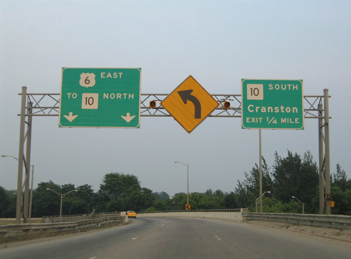
U.S. 6 eastbound curves into the directional interchange with Route 10. Route 10 constitutes a 4.7 mile1 inner belt freeway (Huntington Expressway) around central Providence between Interstate 95 and U.S. 1 at Auburn and Interstate 95 near downtown. U.S. 6 eastbound joins Route 10 northbound between Olneyville and the central business district. Route 10 southbound serves Cranston and Elmwood in south Providence.
Construction removes the bridge pictured here and lowers U.S. 6 east to grade level as the westbound ramp to Plainfield Street is removed.3,4
06/25/05

The southbound off-ramp to Route 10 departs U.S. 6 eastbound ahead of its merge with Route 10 northbound. The inner lane defaults onto the northbound off-ramp to Broadway. The elevated highway includes sharp ramps and sees no shoulders.
06/25/05
U.S. 6 travelers sink below the Westminster Street overpass adjacent to the Route 10 off-ramp to the east-west street. An off-ramp departs here for Broadway, another east-west through street between Olneyville and central Providence.
06/25/05
East 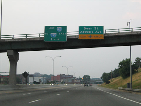
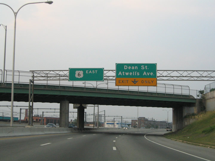
Attached to the Tobey Street southbound flyover to Route 10 are guide signs for Dean Street/Atwells Avenue parclo interchange and the junction with Interstate 95.
06/25/05
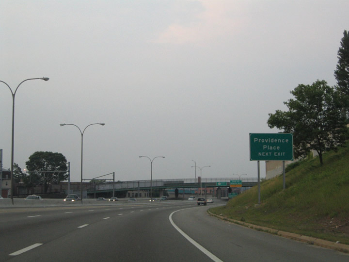
Approaching the Dean Street off-ramp on U.S. 6 east & Route 10 northbound. Dean Street meanders north-south to the west of Interstate 95. Connections with Promenade Street and Kinsley Avenue serve the Providence Place shopping mall.
06/25/05
Atwells Avenue passes over the U.S. 6 & Route 10 freeway ahead of the Dean Street exit. Atwells Avenue splits from Manton Avenue in Dyerville en route to downtown Providence. The surface boulevard ends at U.S. 1 (Sabin Street) adjacent to the Dunkin Donuts Center.
06/25/05

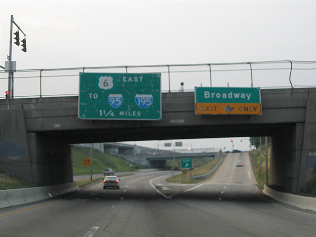
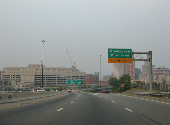
Eastbound at the Dean Street off-ramp on U.S. 6 & Route 10. The freeway prepares to split into three ramps: Interstate 95 north to Boston, Interstate 95 south to New York & Interstate 195 east to Fall River, and Memorial Boulevard east to U.S. 1, U.S. 44, and downtown Providence.
06/25/05
The Memorial Boulevard eastbound off-ramp departs U.S. 6 east & Route 10 north. Memorial Boulevard spurs east from the directional interchange between the two freeways to U.S. 1 (Francis Street) and U.S. 44 (Canal and Steeple Streets). Memorial Boulevard follows the downtown waterfront to Dyer Street.
06/25/05
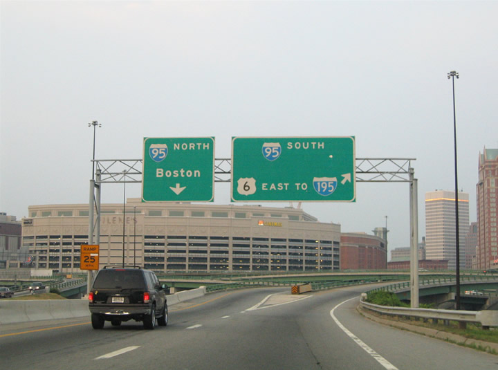
The massive Providence Place mall rises in the background as the Route 10 freeway partitions into ramps for Interstate 95 north and Interstate 95 south & U.S. 6 east. Interstate 95 northbound next splits with the Route 146 freeway (Exit 23) for interests to Boston or Worcester, Massachusetts.
06/25/05
More of the downtown Providence high-rises come into view on the transition ramp of U.S. 6 east from Route 10 north onto Interstate 95 south.
06/25/05
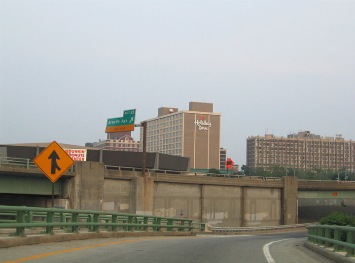
The Interstate 95 southbound off-ramp to Atwells Avenue (Exit 21) departs overhead as U.S. 6 eastbound descends for its merge onto the freeway. The Dunkin Donuts entertainment venue comes into view beyond the elevated freeway.
06/25/05
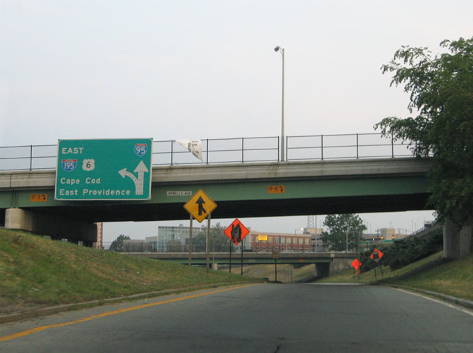
Merging onto Interstate 95 southbound on U.S. 6 eastbound. Atwells Avenue again passes overhead. The diagrammatic overhead pictured here indicated to drivers that a left side off-ramp existed ahead for the U.S. 6 east continuation onto Interstate 195 for East Providence. This ramp no longer exists as Interstate 195 & U.S. 6 now meet Interstate 95 further south at the Iway project.
06/25/05
References:
USRoute1.net.- Dennis J Roberts Expressway (US 6). BostonRoads.com.
- "Magnolia Bridge Removal." Rhode Island Department of Transportation, Press Release, February 19, 2013.
- "US 6 / RI 10 Interchange in Providence." AARoads Forum, online posting by southshore720. August 21, 2013.
Photo Credits:
- Alex Nitzman, Carter Buchanan: 06/25/05
Connect with:
Page Updated Wednesday August 21, 2013.