
Interstate 26 angles southeast from Upstate South Carolina to the LowCountry and Atlantic Coastal Plain. The freeway serves Charleston at the eastern terminus, linking it with the capital city and the Greenville/Spartanburg area (in conjunction with Interstate 385). Northward from the Palmetto State, I-26 continues to Hendersonville and Asheville, North Carolina and the Tri-Cities in eastern Tennessee. Outside of the metro areas in South Carolina, I-26 remains rural, generally with four travel lanes.
Interstate 26 South Carolina Guides
East
The first stretch of Interstate 26 opened in 1960.5
The "Malfunction Junction" area of St. Andrews was slated for a massive overhaul as part of a $80 million improvement project starting in mid 1988 with right of way acquisition. Proposals outlined two new directional ramps from I-26 to I-20, and a collector distributor roadway system northward from I-126 to the St. Andrews Road interchange along I-26.1 Funding for this project however never matriculated.
23 years later, studies and designs were again undertaken to address issues at the exchange between I-20 and I-26. Cost for the project were forecast at $400 million in February 2011, but again funding was not secured.3 Eventually branded as Carolina Crossroads, work on a five phase project upgrading portions of I-20, I-26 and I-126 commenced with a ground breaking ceremony held on November 8, 2021. Phase 3, which replaces the cloverleaf at I-20/26 with a systems interchange, is scheduled to run from 2023 to 2027. The fifth phase, which widens I-26 northwest to Broad River Road, may be completed by the end of 2019.
Interstate 26 was expanded to six overall lanes between U.S. 1 and U.S. 378 in Lexington County during a three year construction project by July 1993. Work here cost $12.1 million.2
Exit 102 with S.C. 60 (Lake Murray Boulevard) was upgraded from a half diamond to a six-ramp parclo interchange during work between March 3, 19974 and late 1999. This construction followed an expansion of I-26 from four to six lanes between Harbison Boulevard and U.S. 176 (Ballentine exit) in December 1993.

Looking northwest at Interstate 26 from the S.C. 72 overpass at Exit 54. A second diamond interchange (Exit 52) for Clinton lies a short distance to the north at S.C. 56. 10/15/01
 scenes scenes |
 | Montague Avenue meets Interstate 26 just south of the exchange with I-526 in the city of North Charleston. The arterial connects the freeway with a number of shopping centers and an outlet mall. Pictured here is the eight lane overpass above I-26 ahead of the westbound on-ramp. 01/18/04 |
 | The westbound entrance ramp for I-26 on Montague Avenue east precedes the intersection with Mall Drive and Goer Street. Goer Street acts as a frontage road for Interstate 26 to the south while Mall Drive encircles the Charles Towne Square retail complex. This I-26 shield and guide sign assembly was subsequently knocked down and removed. 01/18/04 |
   | Burke Road (Road 22) east at the rural diamond interchange (Exit 139) with Interstate 26 near Saint Matthews. 01/03/14 |
   | Old Sandy Run Road (Road 31) arcs 2.40 miles east from Pine Plain Road (Road 65) at Enos to the parclo interchange with Interstate 26 at Exit 125. 09/16/21 |
 | An Interstate 26 trailblazer along Commerce Drive where the off-ramp from I-26 west merges from within the diamond interchange at Exit 113. 08/05/00 |
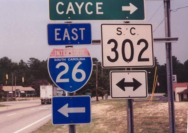 | Commerce Drive and the off-ramp at Exit 113 continue to meet S.C. 302 (Airport Boulevard) at a signalized intersection. S.C. 302 travels a short distance east to end at U.S. 21-176-321 (Charleston Highway). This assembly was removed and a new set of shields were posted for S.C. 302 across Airport Boulevard. 08/05/00 |
  | St. Andrews Road west at the loop ramp onto Interstate 26 east outside Columbia. I-26 proceeds south directly to "Malfunction Junction" with Interstate 20. 06/01/07 |
 | Eastbound S.C. 72 meets I-26 at a diamond interchange outside Clinton. I-26 west splits with I-385 north to Greenville nearby. 10/15/01 |
 | S.C. 72 continues 0.93 miles southwest from the exchange with I-26 at Exit 54 to S.C. 56 (Springdale Drive) and S.C. 72 Business (Willard Road) in Clinton. 10/15/01 |
 | Former sign assembly posted along U.S. 29 north ahead of its cloverleaf interchange with Interstate 26 near Hadden Crossroads. Interstate 26 travels between the cities of Asheville, North Carolina, 60 miles to the north, and Columbia, 80 miles to the south. 12/08/99 |
- "Major Changes for 'Junction' Planned." The State (Columbia, SC), December 11, 1987.
- "I-26 Roadwork Winding Down - Construction Should be Done by July 4." The State (Columbia, SC), June 7, 1993.
- "Malfunction Junction gets initial go-ahead - I-26, I-20." The State (Columbia, SC), February 18, 2011.
- "Work on Interchange May be Traffic-Stopper." The State (Columbia, SC), February 27, 1997.
- "Carolina Century: 1960-1979 Interstate System Was Boon for Some in S.C., But Not All." The State (Columbia, SC), December 21, 1999.
Photo Credits:
- 12/08/99 by AARoads.
- 08/05/00 by AARoads.
- 10/15/01 by AARoads.
- 01/18/04 by AARoads and Carter Buchanan.
- 06/01/07 by AARoads.
- 01/03/14 by AARoads.
- 09/16/21 by AARoads.
Connect with:
Interstate 20
Interstate 77
Interstate 85
Interstate 95
Interstate 126
Interstate 385
Interstate 526
Business Loop I-85
U.S. 1
U.S. 15
U.S. 21
U.S. 17
U.S. 29
U.S. 78
U.S. 176
U.S. 301
U.S. 378
U.S. 601
Page Updated 12-02-2022.