
Early settling of Burlington orientated the village toward the lake as a commercial and transportation center. With the lake representing a primary transportation conduit, a small grid of streets developed between present day Battery and Prospect Streets. By the mid 19th century, railroads built to Burlington ended at terminals along Lake Champlain with exportation representing the main industry. In 1840 lumber importation from Canada overtook exportation with the depletion of area tree stands and lumber finishing mills developed along the lake front areas.

Looking west out over Lake Champlain from Downtown Burlington, Vermont. 08/03/07
Population growth occurred from the 1800s onward, gradually expanding the original street grid outward where topography allowed. Construction of a street car line in the 1890s aided the outward push of Burlington and the town remained an industrial center throughout the first half of the 20th century.
The transition from an industrial based city occurred from the 1950s onward in Burlington. Being the home to three colleges with an ideal setting along scenic Lake Champlain, Burlington transitioned from a mill and factory hub into that of a culture and tourist-based destination. With an ever increasing influx of tourists seeking cooler Mountain air or a lakeside weekend, Burlington, with almost 39,000 residents, finds itself as the regional hub in northwest New England. Redevelopment of the town focuses on losing its industrial path with construction of new homes, condos, and retail development.
Interstates

Guides:
Interstate 89
Interstate 89 represents the main Interstate highway serving western Vermont, traveling northwest from White River Junction and New Hampshire to Burlington and the Canadian border near Swanton. The freeway enters South Burlington from Richmond to the west, curving north at the junction with I-189 and Kennedy Drive through Burlington, Winooski, and Colchester to the Lake Champlain Islands area. I-89 doubles as both a commuter route and through route for tourists and commercial traffic between the Boston area and Montreal, Quebec.
Carrying just four overall lanes, Interstate 89 has one partial and three full interchanges within the Burlington area. A cloverleaf interchange with busy U.S. 2 lies at the heart of Burlington’s suburban style retail hub. A six lane bridge, four general purpose and two auxiliary lanes, crosses the Winooski River near Exit 15.
Interstate 89 opened between South Burlington and Winooski on November 29, 1962. The section between Winooski and Colchester followed on November 1, 1963. The segment from Richmond to South Burlington was completed on November 6, 1963.

Guides:
Interstate 189
Interstate 189 represents is a 1.37 mile long freeway linking I-89 and Kennedy Drive to the east with U.S. 7 (Shelburne Road) and the town of Shelburne to the west. It provides a direct link between U.S. 7 and the south suburbs to Interstate 89 and part of a through route for long distance travelers between southern and northern Vermont.
Two plans for western extensions of Interstate 189 were made since the highway opened on November 29, 1962. The first extension was short, taking I-189 west to a trumpet interchange with the unconstructed Burlington Belt Line freeway. In 1979, I-189 was planned to turn northwest along the Southern Connector, a freeway between U.S. 7 and the intersection of Battery and Maple Streets southwest of Downtown. Neither extension was completed, but the 1979 plan did result in the building of an unopened four lane parkway northwest to Home Avenue two blocks west of Pine Street.
Unconstructed Interstate 189 / Southern Connector

In 1981, the state spent $24 million on the right-of-way land needed to build the Southern Connector, uprooting 21 families in the process. The project even resulted in the construction of 0.7 miles of roadway leading west from exchange joining I-189 with U.S. 7 to Home Avenue. However further north along the projected path was 60 acres of contaminated wetlands designated the Pine Street Barge Canal Superfund Site by the EPA. For decades, the land was contaminated with coal tar deposits emanating from a coal gasification plant. VTrans and other officials thought that clean up efforts would prevail, either by the state or by the EPA.

Guides:
Chittenden County Circumferential Highway
Vermont Route 289 is a short two lane freeway bypassing Essex Junction between VT 117 (River Road) and VT 2A (Colchester Road). With origins dating back to 1965, the limited access highway allows through traffic to bypass the congested five point intersection in Downtown Essex Junction between VT 2A, VT 15 and VT 117. Exit numbers along the route are mileage-based and begin at 7 and end at 13.
Congress devoted $50 million to the Chittenden County Circumferential Highway project in 1982 as part of the Surface Transportation Act. Planned as a 15.8 mile long route, an EIS and Record of Decision (ROD) followed in 1986, with responsibility of the project shifting to VTrans. That same year land acquisition began on the entire route. Vermont 289 was divided into ten segments labeled A through J and construction of Segments C, D, E, and F commenced soon thereafter.

A controversial road due to environmental opposition, VT 289 opened to traffic in October 1993 at a cost of $34.4 million around the town of Essex Junction. Current studies focus on review of the 1986 EIS begun in 2003. An ongoing Draft Environmental Impact Statement (DEIS) readdresses the planned segments leading west through Colchester and south through Williston. Growing traffic concerns, especially along U.S. 2 and in Essex Junction mandate a need for an improved transportation system, and local town leaders have expressed support initially for the highway’s completion. The DEIS is expected to be finalized in Winter 2008.
Essex Junction Belt Line
An early proposal for VT 289 was the Essex Junction Belt Line. Planned as a 3.92 mile limited access route, the belt line would bypass the village from VT 15 (Pearl Street) north and east from its intersection with Suzie Wilson Road to Maple Street (VT 117) near Maplewood Lane and southwest to VT 2A (Park Street) near Mill Street. The routing is complimented by a proposed VT 15 relocation onto an expressway alignment stemming north from the belt line 2.03 miles toward Butler Corners.
Design elements included four overall lanes with 12 foot lanes, a 16 foot median, and 10 foot outside shoulders. Relocated VT 15 included just two 12 foot lanes with 10 foot outside shoulders due to 1985 traffic projections. Total cost of both the belt line and VT 15 expressway was estimated at $5.43 million. Interchange and intersections included on the expressways were as follows:
- Lincoln Street (VT 2A) – folded diamond
- Grandview Avenue extension – at-grade intersection
- Suzie Wilson Road – half diamond with direct westbound ramp onto VT 15 west
- Main Street – at-grade intersection
- Mansfield Avenue extension – at-grade intersection
- Relocated VT 15 expressway – trumpet interchange
- Maple Street – at-grade intersection
- River Street connector – at-grade intersection
- Park Street (VT 2A) – at grade intersection [highway end]
Neither the original Essex Junction Belt Line or the Relocated VT 15 expressway were built as envisioned. VT 289 was eventually built along an alignment much further out from the Essex Junction Town Center. VT 15 remains on its original Main Street alignment leading north and east to Essex Center.
Unconstructed Freeways
Burlington Belt Line
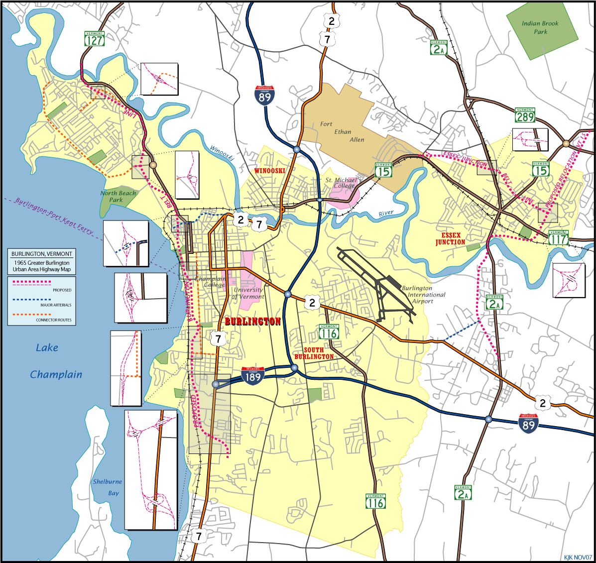
As envisioned in the 1965 Greater Burlington Urban Area Highway Plan, the Burlington Belt Line was designed to provide an alternate route to North Avenue in north Burlington and to alleviate anticipated traffic congested on the Burlington arterial streets. Planned to travel north a limited-access state highway parallel to U.S. 7, the Belt Line freeway would enter the south urban boundary and would cross U.S. 7 north of Bartletts Bay Road, parallel the Vermont Railway to the east toward Battery Park, cross North Avenue and North Street and depart the city street grid at Manhattan Avenue into the Intervale. Continuing north, the Belt Line would skim the eastern reaches of Ethan Allen Park on a northeastern trajectory to Colchester near the Heineburg Bridge, ultimately ending at Interstate 89 within the town.
Planning for the road design includes four general purposes lanes, each 12 feet in width, with 10 foot outside shoulders and a 16 foot median. Interchanges planned includes those with U.S. 7 (Shelburne Road) near Bartletts Bay Road [six-ramp parclo], an extended Interstate 189 [trumpet], Flynn and Lakeside Avenues [split diamond], Main Street [directional T], Ward Street [modified diamond], a connector road to North Avenue near its intersection with Saratoga Avenue [trumpet], and a collector street from Ethan Allen Parkway to North Avenue opposite of its intersection with Loaldo Drive [diamond]. 8.07 miles in total length, it was estimated to cost $26.2 million to construct.
The 1966 Legislature funded a portion of the Belt Line Project that opened in 1971 in the form of a two lane roadway [VT 127] from Manhattan Drive north to North Avenue. Remainders of the project were deemed unfeasible by officials due to the extent of the right-of-way acquisition on the lake front, residential displacement, and lack of funding. However the City of Burlington did not object to the Belt Line project from Main Street south to Interstate 189 as a way to improve access to the CBD.
Southern Connector
In 1975 a consulting engineer hired by the City in 1974 proposed the construction of a new four-lane undivided arterial with at-grade intersections. The road would connect Interstate 189 with Pine Street north of Flynn Avenue along a new roadway following the old Belt Line pathway and upgrade Pine Street northward to Pine Place, where a second new segment would be built connecting the roadway with the south end of Battery Street. This project was dubbed the Southern Connector and funding was sought for its constructing in September 1975 from the federal government.
A Draft Environmental Impact Statement (DEIS) was prepared by the Federal Highway Administration (FHWA) in consultation with Vermont Agency of Transportation (VTrans) in 1977. As part of the DEIS process, borings taken in the wetlands area along the project path of the Southern Connector revealed traces of oil-contamination. Comments from the U.S. Environmental Protection Agency (EPA) suggested to determine the extent of the contamination and the need to excavate and dispose of contaminated material.
Public review and a Corridor Hearing on the 1977 DEIS led to VTrans to recommend a New Location Alternative as the Selected Alternative. The new alternative included a controlled-access route independent of Pine Street, an alignment that would reduce the socio-economic disruption to adjacent neighborhoods. The Alternative was selected in the July 1979 Final EIS (FEIS) that was approved by FHWA.
Project development followed in 1981 that discovered the presence of coal gasification waste within the corridor right of way, an area known as the Pine Street Barge Canal. Officials with the EPA included the site on the National Priorities List (NPL) of Superfund Sites in 1983. This site remains on the list as the Pine Street Barge Canal Superfund Site.
During the spring of 1983, the Burlington Urban Design Study (BUDS) formed to deal with design aspects of the waterfront area. Their scope grew to encompass design elements of citywide growth and development, that included the Southern Connector in 1985. Design modifications involving the Connector included the reduction of the roadway from four to two lanes, landscaping including a median divider, pedestrian and bicycle accommodations, and the use of colored crosswalks and decorative lighting.
A DSEIS was issued in 1984 on the Southern Connector involving the hazardous waste assessment at the Pine Street Barge Canal Superfund Site. Remediation investigations conducted by VTrans however did not meet with the EPA’s approval and therefore the EPA overtook the responsibility for further remedial investigating at the superfund site. The 1984 DSEIS was subsequently withdrawn and attempts by the EPA to remedy the site in 1992-93 were met with public resistance.
Meanwhile in the late 1980s, construction did commence on the “C-1 Section” of the Southern Connector approved in the 1979 FEIS. A four-lane parkway extending west from the Interstate 189 and U.S. 7 interchange to Home Avenue two blocks west of Pine Street was built with the exception of the final pavement overlay, signs, pavement markings, a bike path, and landscaping. Due to the Pine Street Barge Canal Superfund Site, construction on the “C-2” and “C-8” sections were delayed and the “C-1” section never opened to traffic.
Champlain Parkway
Burlington City Council began referring to the Southern Connector as the Champlain Parkway during the 1990s. Officials in 1994 hired a consulting firm to conduct a transportation modeling and traffic operations study on an interim “C-2” section that would bypass the Pine Street Barge Canal Superfund Site. The study concluded that “C-6” was the optimal solution. VTrans followed with their own traffic analysis in 1995 and 1996 and issued a Supplemental EIS (SEIS) in January 1995 on impacts with a routing that bypassed the superfund site and allowed the completion of the 1979-approved Southern Connector alternative.
The 1996 Burlington Municipal Development Plan addressed the Champlain Parkway as a designated truck route designed to remove trucks from residential streets and as a alternate route into the city designed to remove through traffic from adjacent residential streets. Discussion on a March 7, 1996 Public Information Meeting debated the need of four versus two lanes and the need to blend roadway into the existing residential neighborhoods with its design. In 1997, VTrans prepared at FSEIS on a preferred interim alternative around the Pine Street Barge Canal Superfund Site, which was approved by the FHWA in August of 1997.
On October 21, 1998, VTrans and the City of Burlington agreed to share responsibilities of the Champlain Parkway project. Design engineering services followed on the interim alternative selected in 1997 in 1999. Public feedback continued through 2000 and the 2001 Burlington Municipal Development Plan carried forward the same objectives addressed in the 1996 plan involving the road as a truck and alternate route into Downtown, but as a two lane roadway instead of a four lane one. In March 2002, the City of Burlington modified the 1979 Selective Alternative and the 1997 Interim Alternative with the public feedback obtained, officially downsizing the road from a four to two lane facility. This development officially removed the “C-8” section through the superfund site from the project and endorsed the “C-1”, “C-2” and “C-6” alternatives as the permanent alignment.
Descriptions of the Sections:
- “C-1” – reconstruction of the Interstate 189 interchange with U.S. 7 (Shelburne Road) and the building of 0.6-miles of roadway from the interchange to Home Avenue. This was built in the late 1980s as a four-lane roadway.
- “C-2” – extends the Champlain Parkway northward from “C-1” at Home Avenue 0.7 miles to Lakeside Avenue. Right-of-way was already acquired for “C-2” as a four-lane highway.
- “C-8” – alignment north through the Pine Street Barge Canal Superfund Site between Lakeside Avenue and Main Street. A remediation plan was begun by the EPA at the superfund site.
- “C-6” – the interim alternative approved in the 1997 FSEIS, utilizes the existing street network via Lakeside Avenue to Pine Street and Pine Street north to the proposed Battery Street Extension at Pine Place. “C-6” continues along the Battery Street Extension northwest to Battery Street and along Battery Street to Main Street, the same end of the “C-8” alternative.
The 2006 Burlington Municipal Development Plan copies the same objectives sought in the 2001 Plan for the Champlain Parkway. Redesign of the parkway in 2001 downsized it from a limited access highway into a city street with bike lanes, sidewalks and trees. The objectives remain the same: designate the parkway as a truck route, as an alternate through route into Downtown, and blend the road into existing neighborhoods by constructing a two lane highway with narrow lanes, low design speeds, and safe pedestrian crossings.
A letter issued by Burlington Mayor Bob Kiss on August 4, 2006 endorsed construction of the Champlain Parkway and mentioned a new roadway from Interstate 189 to the intersection of Pine Street and Lakeside Avenue. It went on to reference improvements to existing Pine Street, east of the Pine Street Barge Canal Superfund Site {section “C-6”) and north to Maple Street, including sidewalk, streetscaping, road improvements and new traffic lights at Maple and King Streets. Mayor Kiss indicated that work might begin as early as Spring 2007, but construction did not commenced until 2022.
U.S. Highways

Guides:
U.S. Route 2
Providing the main east-west commercial arterial for Burlington, U.S. 2 joins Downtown with South Burlington and the shopping mall areas near Interstate 89. Additionally U.S. 2 joins the University of Vermont (UVM) campus with Interstate 89 via the cloverleaf interchange at Exit 14.
U.S. 2 is four lanes wide from the UVM campus east to Kennedy and Airport Drives near Burlington International Airport. Known as Williston Road, the arterial is very congested during afternoon and evening hours with commuters, college traffic, and airport travelers.
Continuing east, U.S. 2 reduces to two lanes but remains a busy route between South Burlington and the Taft Corners of Williston. The highway parallels I-89 closely from Williston east to Richmond and Montpelier.
Northward, U.S. 2 joins U.S. 7 at the intersection of Main and Willard Streets. U.S. 2 west / U.S. 7 north follow Willard and Hyde Streets between Main Street and Riverside Avenues. U.S. 2 east / U.S. 7 south use Winooski Avenue southbound between Riverside Avenue and Main Street.
Riverside Avenue, reconstructed between 2005-07, skims the Winooski River eastward from Willard and Winooski Avenues to the Winooski River Bridge at Colchester Avenue. Built in 1926, the Winooski River Bridge carries four overall lanes between the city of Burlington and Downtown Winooski. The western end of VT 15 (Allen Street) lies just north of the bridge at a recently built roundabout. New development along the north banks of the river lies at the southeast corner of U.S. 2/7 and VT 15 in the form of new condos and shops, a testament to the redevelopment of the town.
U.S. 2/7 remain overlapped northward along Main Street in Winooski to I-89 at Exit 16. U.S. 2/7 continue along Roosevelt Highway with two lanes through Colchester to Chimney Corner. There U.S. 2 turns west toward the Sandbar bridge and road, which were constructed across Lake Champlain in 1906-10. U.S. 7 maintains a northward heading into Milton.

Guides:
U.S. Route 7
Complimenting U.S. 2 from the south in commuter and through traffic interests is U.S. 7. Following Shelburne Road, U.S. 7 travels an increasingly congested route from the Chittenden County line northward through Shelburne and South Burlington. The highway increases from a two-lane rural route into a five lane commercialized arterial in the process. Growth along the corridor continues as Burlington expands outward and tourist traffic increases.
Congestion peaks near the parclo interchange with Interstate 189 near the Burlington and South Burlington city lines. The unconstructed Southern Connector was to alleviate traffic along U.S. 7 leading northward into the Burlington central business district. That project eventually got underway in 2022 as Champlain Parkway.
U.S. 7 follows Shelburne Street northward from I-189 to a couplet at Main Street. U.S. 7 north follows Willard and Hyde Streets to the east of southbound U.S. 7 along South Winooski Avenue and Main Street east. The partitioned U.S. 7 converges with U.S. 2 along the same street couplet northward to Riverside Avenue. U.S. 2/7 combine through Winooski and Colchester and before splitting at Chimney Corner south of Milton. U.S. 7 continues in the shadow of Interstate 89 northward through St. Albans, Swanton, and Highgate Springs.
In an effort to remove traffic from city streets, the city of Burlington signs St. Paul Street leading south from Downtown as U.S. 7 Alternate. St. Paul Street comprises of a two lane roadway from Downtown to South Winooski Street one block north of Willard Street. U.S. 7 Alternate was an attempt to address the congestion issues caused by U.S. 7 on adjacent residential streets in the wake of the unconstructed Southern Connector and pending upgrade to Pine Street.
State Routes

Guides:
Vermont Route 2A
The 1965 Greater Burlington Urban Area Highway Plan outlines a proposal for a short expressway along VT 2A leading southwest from near the Winooski River to a reconstructed Industrial Avenue at Brownell Road and southeast from there to VT 2A north of U.S. 2 at Tafts Corner. Four lanes were planned for the 1.26 mile long section between Industrial Avenue and VT 2A near the south end of the unconstructed Essex Belt Line. Only two lanes were planned for the 0.78 mile long section leading south but with provisions made for potential four-laning when traffic counts warranted it. Future extension of the highway southward to the Williston interchange of Interstate 89 was also considered. No elements of the $1.52 million Williston Expressway were ever built however.

Guides:
Vermont Route 15
An expressway for VT 15 was planned in 1965 as part of the original Essex Junction Belt Line proposal. Planned as a two lane controlled access route, the relocation of VT 15 would have traveled from a trumpet interchange with the belt line east of Downtown north to a point one half mile east of Butler Corners. The northernmost segment of the expressway would tie into VT 15 (Center Road) where it presently intersects Essex Way.

Guides:
Vermont Route 116
Vermont Route 116 travels south from U.S. 2 (Williston Road) along Hinesburg Road through South Burlington. The highway primarily serves older residential areas north of Interstate 89 and new suburban growth south of the freeway.

Guides:
Vermont Route 117
Vermont Route 117 follows Maple Street and River Road east from Downtown Essex Junction parallel to the Winooski River. The highway provides a direct route between Essex Junction and Interstate 89 independent of Williston. Presently VT 289 ends at VT 117 east of Essex Junction at a half diamond interchange.

Guides:
Vermont Route 127
The addition of the Federal Aid Secondary System created Vermont Route 127 along Pearl Street and North Avenue from Downtown Burlington northwest through north Burlington. In the early 1960s, Vermont was relocated from Pearl Street onto an alignment utilizing Main, Battery, Park, and Sherman Streets leading to North Avenue in anticipation of future improvements. Furthermore, completion of the Burlington Belt Line north from Main Street was slated to be designated VT 127 if completed.
VT 127 today represents a portion of the original Burlington Belt Line project. Segments constructed as part of the Belt Line include VT 127 (Ethan Allen Parkway) south from Plattsburg Avenue (old VT 127) in north Burlington to Manhattan Drive, the trumpet interchange with the North Avenue and connector near Saratoga Avenue, and a new Heineburg Bridge over the Winooski River that replaced the original VT 127 span to the west. North Avenue, the former VT 127 alignment, remains an unsigned route through it would be well suited as VT 127 Business.
VT 127 follows Battery and Park Streets north from Main Street to the Ethan Allen Parkway beginning at Manhattan Avenue. The parkway constitutes a two lane expressway to the east of North Avenue through an area called the Intervale. A trumpet interchange and two pedestrian overpasses lie along the controlled-access route.
Plattsburg Avenue meets the north end of the expressway near the Winooski River bridge. VT 127 downgrades into a residential route with slow speed limits and numerous driveways and at-grade intersections. Once at Malletts Bay, VT 127 turns east along Lakeshore Drive through Bayside Park and a marina district. The state road follows Blakely Road over Interstate 89 with no access and ends at U.S. 2/7 opposite Severance Road in Colchester.
Unrealized plans called for extending the Chittenden Circumferential Highway westward to the expressway along VT 127. A DEIS was conducted on the Burlington bypass route by 2007.
Other Roads
Kennedy Drive
Kennedy Drive represents a four lane arterial leading east from the Interstate 189 ramps at Dorsett Street to U.S. 2 (Williston Road) at Airport Drive. Airport Drive connects U.S. 2 and Kennedy Drive with the terminal of Burlington International Airport. Kennedy Drive was built in conjunction with I-189. Westbound defaults onto I-189 to U.S. 7 (Shelburne Road) after the signalized intersection with Dorsett Street.
Sources:
- “Superfund, The Road to Nowhere, Day 2.” The Burlington Free Press, February 8, 1993.
- VTrans Project Page
http://www.aot.state.vt.us/EIS/Default.htm: Chittenden County Circumferential Highway (CCCH) - 1965 Greater Burlington Urban Area Highway Plan
- “Draft Supplemental Environmental Impact Statement – Southern Connector/Champlain Parkway.
http://www.aot.state.vt.us/progdev/Sections/LTF/” VTrans, October 2006.
SouthernConnectorSEIS/SouthernConnectorDraftSEISTableOfContents.htm - 2001 Burlington Municipal Development Plan
- 2006 Burlington Municipal Development Plan
- “From the Desk Mayor Bob Kiss, Number 1.
http://www.ci.burlington.vt.us/mayor/letters/mayor_letter_20060804.php” The City of Burlington, Vermont, August 4, 2006.
Page updated 11/10/07.