

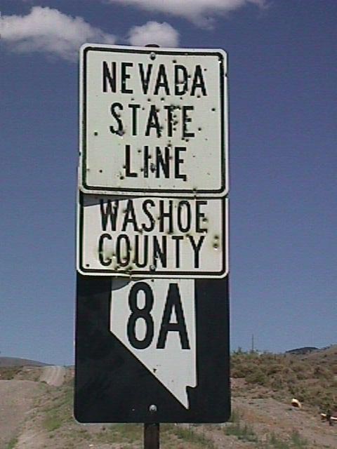
California 299 previously ended opposite Nevada 8A near Vya in a remote area of northwestern Washoe County near Fortynine Mountain. Photos by Mike Ballard (08/12/99).
| ROUTE | STATUS | DESCRIPTION | COUNTY | MILEAGE | NAMES |
|---|---|---|---|---|---|
| NV 1 | Deleted; Pre-1976 | Previous designation for Interstate 80 from California State Line near Verdi east to Utah State Line near Wendover; Also previous designation for U.S. 40 and Nevada 221, 223, 289, 304, 396, 425, 427, 535, 647, 668, 794, Interstate 80, and part of U.S. 95A | Washoe Storey Lyon Churchill Pershing Humboldt Lander Eureka Elko |
— | Victory Highway, Interstate 80 |
| NV 1A | Deleted; Pre-1976 | Previous designation for U.S. 95 between Schurz and Interstate 80 (Milepost 83) near Humboldt Flats | Churchill | — | Bonanza Highway |
| NV 1B | Deleted; Pre-1976 | Previous designation for U.S. 95A between Silver Springs and Fernley | Lyon | — | U.S. 95 Alternate |
| NV 2 | Deleted; Pre-1976 | Previous designation for Nevada 722, U.S. 50, U.S. 50A, U.S. 93 from Fernley to Utah State Line via Fallon, Austin, Eureka, Ely, Lages, and an unimproved road at Tippett and Goshute Indian Reservation | Lyon Churchill Lander Eureka White Pine Elko |
— | Lincoln Highway |
| NV 2A | Deleted; Pre-1976 | Previous designation for U.S. 50 between Carson City and Leetville (U.S. 50A) | Carson City Washoe Lyon Churchill |
— | Lincoln Highway |
| NV 2B | Deleted; Pre-1976 | Previous designation for U.S. 95A between U.S. 50 southwest of Silver Springs and Yerington via Wabuska | Lyon | — | U.S. 95 Alternate |
| NV 2C | Deleted; Pre-1976 | Previous designation for unimproved road between Nevada 208 south of Yerington east to U.S. 95 near Walker Lake | Douglas Mineral |
— | |
| NV 3 | Deleted; Pre-1976 | Previous designation for Nevada 208, 266, 430, U.S. 50, U.S. 95, U.S. 95A, and U.S. 395 from Reno south to Oasis, California, via Carson City, Holbrook, Wellington, Yerington, Schurz, Hawthorne, Coaldale, Tonopah, Stonewall, and Lida | Washoe Carson City Douglas Mineral Esmeralda Nye |
— | |
| NV 3A | Deleted; Pre-1976 | Previous designation for Nevada 264 and 773; from near Oasis, California, north to U.S. 6 near Coaldale through Fishlake Valley | Mineral | — | Fish Lake Valley Road and Dicalite Cutoff |
| NV 3B | Deleted; Pre-1976 | Previous designation for Nevada 428 | Washoe | — | East Lake Boulevard |
| NV 3C | Deleted; Pre-1976 | Previous designation for unimproved road between Nevada 208 south of Yerington south to connect to California 270 east of Bodie State Park in California | Douglas | — | |
| NV 4 | Deleted; Pre-1976 | Previous designation for U.S. 6 between Tonopah and Ely | Nye White Pine |
— | Midland Trail |
| NV 5 | Deleted; Pre-1976 | Previous designation for Nevada 579, 599, 601, and U.S. 95 (between Las Vegas and Stonewall) | Nye Clark |
— | Bonanza Highway |
| NV 5B | Deleted; Pre-1976 | Previous designation for Nevada 602 | Clark | — | Casino Center Boulevard |
| NV 6 | Deleted; Pre-1976 | Previous designation for Interstate 15 from California State Line near Stateline northeast to Arizona State Line near Mesquite; includes parts of Nevada 601 and 604 and U.S. 91-93-466. | Clark | — | Mojave Freeway |
| US 6 | Current Established: 7/1/76 |
From California State Line southwest of Montgomery Pass easterly to a point on U.S. 95 at Coaldale Junction and from another point from U.S. 95 in Tonopah northeasterly to a point on U.S. 50 (US 50, 93, and 6 Pioche Highway) in Ely. | Mineral Esmeralda Nye White Pine |
15.204 19.141 130.223 37.946 |
Midland Trail; Blue Star Memorial Highway; Montgomery Pass Road |
| NV 6A | Deleted; Pre-1976 | Previous designation for Nevada 601 in Las Vegas | Clark | — | Main Street |
| NV 6B | Deleted; Pre-1976 | Previous designation for a portion of Nevada 604 | Clark | — | Las Vegas Boulevard |
| NV 7 | Deleted; Pre-1976 | Previous designation for Nevada 168, U.S. 93 between Glendale and Conner’s Junction | Clark Lincoln White Pine |
— | Moapa Road; Great Basin Highway |
| NV 8 | Deleted; Pre-1976 | Previous designation for U.S. 95 between Winnemucca and McDermitt | Humboldt | — | Bonanza Highway |
| NV 8A | Deleted; Pre-1976 | Previous designation for Nevada 140, Nevada 305, Nevada 376 from Vya (California Nevada 299) southeast to Tonopah via Winnemucca, Battle Mountain, and Austin. In spite of the fact that east-west Nevada 8A has been decommissioned from the state route system, there are still signs for both it and north-south Nevada 34 in the sparsely populated corner of Northwestern Nevada. Nevada 8A is described by Deke Castleman as “a good road — graded and drained gravel, comfortable even at 45-50 miles per hour” (Castleman, 211). Nevada 8A and Nevada 34 meet in Vya, a crossroads more than a town. There is a Vya Maintenance Station near here, and it is unclear if this is a state or county facility. Nevada 8A and 34A ultimately join Nevada 140 near Denio. | Washoe Humboldt Lander Nye |
— | Austin-Battle Mountain Road; Tonopah-Austin Road |
| NV 8B | Deleted; Pre-1976 | Previous designation for Nevada 290 | Humboldt | — | Paradise Valley Road |
| NV 9 | Deleted; Pre-1976 | Previous designation for U.S. 395 from Reno north to California State Line | Washoe | — | U.S. 395 |
| NV 10 | Deleted; Pre-1976 | Previous designation for Nevada 360 and U.S. 6 between California State Line and Rhodes via Basalt | Mineral | — | Mine/Basalt Cutoff Road; Montgomery Pass Road |
| NV 11 | Deleted; Pre-1976 | Previous designation for Nevada 225, 226, 229, and several unimproved roads from Elko to Owyhee via Tuscaroa, Jack Creek, Deep Creek, and Whiterock | Elko | — | Mountain City Highway |
| NV 12 | Deleted; Pre-1976 | Previous designation for Nevada 169 from Glendale south to Lake Mead National Recreation Area; proposed to continue east to Arizona State Line via a ferry across the Virgin River and then east along an unimproved road through the Virgin Mountains | Clark | — | Moapa Valley of Fire Boulevard; Rainbow Boulevard |
| NV 13 | Deleted; Pre-1976 | Previous designation for U.S. 93 from Lages (Goshute Lake/U.S. 93A) north to Jackpot (Idaho State Line) via Wells | Elko | — | Great Basin Highway |
| NV 14 | Deleted; Pre-1976 | Previous designation for U.S. 6-50 and U.S. 93 between Ely and Utah State Line | White Pine | — | |
| NV 15 | Deleted; Pre-1976 | Previous designation for U.S. 6 between Basalt and Coaldale | Mineral Esmeralda |
— | Midland Trail |
| I-15 | Current Established: 7/1/76 |
From California State Line southwest of Las Vegas via Las Vegas and Glendale to the Arizona State Line near Mesquite. | Clark | 123.774 | Interstate 15; Mojave Freeway |
| NV 16 | Deleted; Pre-1976 | Previous designation for Nevada 160 from near Browns Camp southeast to Las Vegas | Nye Clark |
— | Pahrump Valley Road; Blue Diamond Road |
| NV 17 | Deleted; Pre-1976 | Previous designation for Nevada 341 through Virginia City between U.S. 395 and US 50 | Washoe Storey |
— | Geiger Grade Road |
| NV 18 | Deleted; Pre-1976 | Previous designation for Nevada 789 and unimproved roads; was to connect Intersatte 80/U.S. 40/Nevada 1 at Golconda with Nevada 11 near Tuscarora via Midas. The original alignment of Nevada 18 is still in use today as the main connection to the tiny community of Midas, and the routing between Golconda and Midas is reported to be the easier drive. | Humboldt Elko |
— | Getchell Mine Road; Golconda-Midas Road |
| NV 18A | Deleted; Pre-1976 | Previous designation for Nevada 806 from Battle Mountain to North Battle Mountain; then via an unimproved road from North Battle Mountain to meet Nevada 789 (former Nevada 18) northeast of Golconda | Lander Humboldt |
— | Reese Street; North Battle Mountain Road |
| NV 19 | Deleted; Pre-1976 | Previous designation for Nevada 206, 207, 757, and U.S. 395 from California-Nevada State Line near Topaz Lake north to Carson City | Douglas | — | Fairview Lane; Foothill Boulevard; Genoa Lane; Jacks Valley Road |
| NV 20 | Deleted; Pre-1976 | Previous designation for Nevada 379 and unimproved road; was proposed to connect U.S. 50 south of Eureka with U.S. 6 at Callaway (Currant) via Duckwater | Eureka White Pine Nye |
— | Duckwater Road |
| NV 21 | Deleted; Pre-1976 | Previous designation for Nevada 306 and unimproved road from Interstate 80 (U.S. 40/Nevada 1) south to Austin via Beowawe/Crescent Valley; was proposed to continue south from Austin via Humboldt-Toiyabe National Forest toward Nevada 844 (near Ione) | Lander Eureka |
— | Gold Acres Road |
| NV 22 | Deleted; Pre-1976 | Previous designation for Nevada 338 and 829 from Wellington south to California State Line (connect to California 182) via Sweetwater Summit | Douglas | — | Sweetwater Road |
| NV 23 | Deleted; Pre-1976 | Previous designation for Nevada 361 from Luning (Nevada 3/US 95) north to U.S. 50 at Middlegate | Churchill Mineral Nye |
— | Gabbs Valley Road |
| NV 24 | Deleted; Pre-1976 | Previous designation for U.S. 93 and U.S. 93A (former U.S. 50/50A) from Schellbourne (near Cherry Creek) to Wendover | White Pine Elko |
— | Great Basin Highway |
| NV 25 | Deleted; Pre-1976 | Previous designation for Nevada 319 and 375 from Tonopah east to Lien via “Area 51,” Rachel, Caliente, Panaca | Nye Lincoln |
— | Extraterrestrial Highway; Y Z Road; Warm Springs Road |
| NV 26 | Deleted; Pre-1976 | Previous designation for U.S. 93 between Henderson and Boulder City | Clark | — | Boulder Highway |
| NV 27 | Deleted; Pre-1976 | Previous designation for Nevada 431 between Nevada 28 and U.S. 395/Nevada 3 | Washoe | — | Mount Rose Highway |
| NV 28 | Current Established: 7/1/76 |
From U.S. 50 at Spooners Junction northerly to California State Line near Crystal Bay, Nevada 28 is a continuation of California 28. Together with U.S. 50 and California 89 between South Lake Tahoe and Tahoe City, Nevada 28 forms part of the ring road around Tahoe. It appears that either Nevada DOT or Caltrans decided to share the same number for the highway between Tahoe City and Spooner Junction via Incline Village. Interestingly, only Nevada 28, 88, 140, and 266 carry their numbers into other states. Prior to the 1980 renumbering of all Nevada state routes, several other Nevada carried their numbers forward from state-to-state also, including Utah/Nevada 30, which is now Utah 30/Nevada 233. | Douglas Carson City Washoe |
1.233 3.950 10.991 |
Tahoe Boulevard; North Shore Road |
| NV 29 | Deleted; Pre-1976 | Previous designation for Nevada 373 from Nevada 5/U.S. 95 south to California State Line (to California 127) | Nye | — | Death Valley Junction Road |
|
NV 30 Deleted; Pre-1976Previous designation for Nevada 233; from Oasis northeast to Utah State Line; connects to Utah 30 via Montcello. Ironically, Utah redesignated its former Utah 70 to Utah 30 to provide route numbering continuity; Nevada responded by changing its Nevada 30 to Nevada 233.Elko–Montello Road |
|||||
| NV 31 | Deleted; Pre-1976 | Previous designation for Nevada 359 and 839 from Hawthorne south to California State Line (California 167) | Mineral | — | E Street; Pole Line Road |
| NV 32 | Deleted; Pre-1976 | Previous designation for Nevada 445 in Sparks; connected to Nevada 33 to north | Washoe | — | Pyramid Way; Pyramid Lake Road |
| NV 32A | Deleted; Pre-1976 | Previous designation for Nevada 663 in Reno-Sparks (Oddie Boulevard) | Washoe | — | Oddie Boulevard |
| NV 33 | Deleted; Pre-1976 | Previous designation for Nevada 443, 445, and 880 from Reno northeast to Pyramid Lake | Washoe | — | Clear Acre Lane; Sun Valley Drive |
| NV 33A | Deleted; Pre-1976 | Previous designation for Nevada 660 in Reno-Sparks area | Washoe | — | Sierra Street |
| NV 33B | Deleted; Pre-1976 | Previous designation for Nevada 648 in Reno-Sparks area | Washoe | — | Second Street and Glendale Avenue |
| NV 34 | Deleted; Pre-1976 | Previous designation for Nevada 447 from Wadsworth north to Gerlach and an unimproved road from Gerlach north to the Oregon State Line via Vya. The unimproved section of this route is still signed as Nevada 34, even though it is no longer in the state route system. | Washoe | — | Gerlach Road |
| NV 34A | Deleted; Pre-1976 | Unimproved road from deleted Nevada 34 in Long Valley north of Vya east to Nevada 140 (former Nevada 8A) in Humboldt National Wildlife Refuge. It still has at least one reassurance shield along its route. According to one correspondent, “I’ve actually spent a great deal of time on the unimproved roads of northwestern Nevada. Last spring, on a rock hounding trip, I spent several days traversing Nevada 34A and Nevada 34. Nevada 34A has one marker at the junction of 34A and 140 that I’ve been able to find. My mother-in-law, who used to live and ranch in/around Lakeville, California, insists that California 299, as it leaves California and enters Nevada was commonly referred to back in the late 1950s as Highway 140A.” | Washoe Humboldt |
— | |
| NV 35 | Deleted; Pre-1976 | Previous designation for Nevada 490 to connect Schellbourne and Cherry Creek | White Pine | — | – |
| NV 37 | Deleted; Pre-1976 | Previous designation for Nevada 88 | Douglas | — | Woodfords Road |
| NV 38 | Deleted; Pre-1976 | Previous designation for Nevada 318 between Hiko (Ash Springs) area north to U.S. 6 near Preston | Lincoln Nye White Pine |
— | Sunnyside Road |
| NV 38A | Deleted; Pre-1976 | Previous designation for Nevada 318 ; shown on map in place of Nevada 38 in 1938 | Lincoln Nye White Pine |
— | Sunnyside Road |
| NV 39 | Deleted; Pre-1976 | Previous designation for Nevada 157 into Charleston Peak area | Clark | — | Charleston Park Road; Kyle Canyon Road |
| NV 40 | Deleted; Pre-1976 | Previous designation for unnumbered road between Interstate 15 Exit 75 and Lake Mead National Recreation Area | Clark | — | |
| US 40 | Deleted by 1978 | Previous designation for Interstate 80 between 1926 and 1975. U.S. 40 used to connect San Francisco with Atlantic City, but it was curtailed near Park City, Utah, in 1975. U.S. 40 was replaced by freeway sections of Interstate 80 in sections, starting in 1959 and ending in 1983. | Washoe Storey Lyon Churchill Pershing Humboldt Lander Eureka Elko |
— | Victory Highway; Interstate 80 |
| NV 41 | Deleted; Pre-1976 | Previous designation for Nevada 146 and 147 (and Nevada 166, which is not maintained by NDOT) | Clark | — | Lake Mead Drive; Lake Mead Boulevard; Sunset Road; Lakeshore Drive |
| NV 42 | Deleted; Pre-1976 | First, this was the previous designation for U.S. 93 east of Boulder City to Arizona State Line via Hoover (Boulder Dam) | Clark | — | Boulder Highway |
| NV 42 | Deleted; Pre-1976 | Nevada 42 was also used as the previous designation for Nevada 116 east of Fallon (Stillwater Road) | Churchill | — | Stillwater Road |
| NV 43 | Deleted; Pre-1976 | Previous designation for Nevada 225 from Nevada 226 (Former Nevada 11/43 split) north to Mountain City (Former Nevada 11A/43 split) | Elko | — | Mountain City Highway |
| NV 44 | Deleted; Pre-1976 | Not in State Highway System; was spur from U.S. 50 west of Ely southwest to Ruth and Kimberly | White Pine | — | |
| NV 45 | Deleted; Pre-1976 | Previous designation for Nevada 655 from Interstate 80 (U.S. 40/Nevada 1) Patrick Interchange south to Virginia City (Nevada 341) | Washoe Storey |
— | |
| NV 46 | Deleted; Pre-1976 | Previous designation for Nevada 227 and 228; originally planned to connect Eureka with Elko via unimproved road to west of Diamond and Ruby Mountains via Jiggs and Te-Moak Indian Reservation | Eureka White Pine Elko |
— | Lamoille Highway |
| NV 47 | Deleted; Pre-1976 | Previous designation for Nevada 265 from U.S. 6-95 east of Coaldale south to Silverpeak and Nivloc | Esmeralda | — | Silver Peak Road |
| NV 48 | Deleted; Pre-1976 | Previous designation for Nevada 399, 400, and 854 from Interstate 80 (U.S. 40, Nevada 1) at Lovelock northwest to near Eagle Picher Mine; then northwest along unimproved road to meet former Nevada 49 east of Gerlach | Humboldt | — | Eagle Picher Mine Road |
| NV 49 | Deleted; Pre-1976 | Unimproved road from Nevada 447 (former Nevada 34) near Gerlach east to Winnemucca via Sulphur and Jungo | Humboldt, Pershing | — | |
| NV 50 | Deleted; Pre-1976 | Previous designation for Nevada 858 | Douglas | — | Oreana Road |
| US 50 | Current Established: 7/1/76 Modified: 4/9/81; 2014 |
From California State Line at South Lake Tahoe easterly to its junction with U.S. 395 (SR 529) Carson Street) south of Carson City and from SR 530 (William Street) east of Carson City easterly via Fallon, Austin, Eureka, and Ely to the Utah State Line near Baker. | Douglas Carson City Lyon Churchill Lander Eureka White Pine |
15.128 11.307 35.398 106.846 56.898 47.385 131.113 |
Lincoln Highway; “The Loneliest Road in America” |
| US 50A (1) | Deleted | Previous designation for U.S. 50 when U.S. 50 was routed along Nevada 119 (Berney Road) and U.S. 95 through Fallon | Churchill | – | U.S. 50 Alternate |
| US 50A (2) | Deleted by 1976 | Between 1954-1976, U.S. 50A was defined to run along U.S. 93A between the 93/93A split at Lages/Goshute Lake; Interstate 80/U.S. 40 east across the Great Salt Desert in Utah, through Salt Lake City, south along Interstate 15/U.S. 91 to meet U.S. 50 south of Provo. Utah discontinued certain overlapping sections in 1972. | Elko White Pine |
– | Lincoln Highway |
| US 50A (3) | Current Established: 7/1/76 Modified: 12/14/76; 10/16/77; 12/31/87 |
From U.S. 95 Alternate east of Fernley easterly via Hazen to U.S. 50 at Leeteville Junction; not signed until 1977. | Lyon Churchill |
7.765 9.291 |
U.S. 50 Alternate |
| NV 51 | Deleted; Pre-1976 | Previous designation for parts of Nevada 225 and 278 | Elko Eureka |
– | Parts of Mountain City Highway and Eureka-Carlin Road |
| NV 52 | Deleted; Pre-1976 | Previous designation for Nevada 156 and 372 between U.S. 95 (SR 5) along Nevada 156 to Spring Mountain National Recreation Area across trail near Charleston Peak to connect to Pahrump and current Nevada 372 | Clark | – | Lee Canyon Road and Charles Brown Highway |
| NV 53 | Deleted; Pre-1976 | Previous designation for Nevada 161 between Jean and Goodsprings; proposed to continue west to California State Line near Sandy Valley and Kingston, California | Clark | – | Goodsprings Road |
| NV 54 | Deleted; Pre-1976 | Not in State Highway System; Spur from U.S. 93 near Panaca west to Cathedral Gorge State Park | White Pine | – | |
| NV 55 | Deleted; Pre-1976 | Not in State Highway System; Spur from U.S. 93 near Caliente south to Kershaw Canyon-Ryan State Park | White Pine | – | |
| NV 56 | Deleted; Pre-1976 | Previous designation for Nevada 756 | Douglas | – | Centerville Road |
| NV 57 | Deleted; Pre-1976 | Previous designation for Nevada 206 | Douglas | – | Foothill Road & Genoa Lane |
| NV 58 | Deleted; Pre-1976 | Previous designation for Nevada 374 from Beatty (U.S. 95) to California State Line | Nye | – | Daylight Pass Road; Death Valley Road |
| NV 59 | Deleted; Pre-1976 | Previous designation for Nevada 397 near Lovelock | Pershing | – | Westergard Road; South Meridian Road |
| NV 60 | Deleted; Pre-1976 | Previous designation for Nevada 165 from U.S. 95 southeast to Nelson | Clark | – | Nelson Road |
| NV 61 | Deleted; Pre-1976 | Previous designation for Nevada 117 near Fallon | Churchill | – | Scheckler Road |
| NV 62 | Deleted; Pre-1976 | Previous designation for Nevada 118 near Fallon | Churchill | – | Wildes Road |
| NV 65 | Deleted; Pre-1976 | Previous designation for Nevada 513 | Carson City | – | Fifth Street; Carson River Road |
| NV 66 | Deleted; Pre-1976 | Previous designation for Nevada 398 near Lovelock | Pershing | – | Main Street; North Meridian Road; Fairview Road |
| NV 68 | Deleted; Pre-1976 | Previous designation for Nevada 164 between California State Line (Nipton Road) and Lake Mead National Recreation Area boundary via Searchlight | Clark | – | Nipton Road |
| NV 69 | Deleted; Pre-1976 | Previous designation for Nevada 377 from Nevada 376 (SR 8A) east to Manhattan | Nye | – | Manhattan Road |
| NV 70 | Deleted; Pre-1976 | First, Nevada 70 was a previous designation for Nevada 673 and U.S. 395 | Washoe | – | Stead Boulevard |
| NV 70 | Deleted; Pre-1976 | Second, Nevada 70 was a previous designation for Nevada 378 from Nevada 376 (SR 8A) east to Round Mountain | Nye | – | Round Mountain Road |
| NV 71 | Deleted; Pre-1976 | Previous designation for Nevada 774 from Nevada 266 east of Lida southwest to Gold Point and unimproved south to California State Line | Esmeralda | – | Lida Road; Midland Trail |
| NV 72 | Deleted; Pre-1976 | Previous designation for Nevada 267; from U.S. 95 (Scotty’s Castle) southwest to California State Line | Nye | – | Scotty’s Castle Road; Grapevine Canyon Road |
| NV 73 | Deleted; Pre-1976 | Previous designation for Nevada 487; between U.S. 6-50 and Utah State Line (Utah 21) | White Pine | – | Baker Road |
| NV 74 | Deleted; Pre-1976 | Previous designation for Nevada 488 from Nevada 487 in Baker west to Great Basin National Park (Lehman Caves National Monument) | White Pine | – | Lehman Caves Road |
| NV 75 | Deleted; Pre-1976 | Unimproved road from Nevada 319 just east of Panaca southeast to Utah State Line and Dixie National Forest Boundary via Crestline | Lincoln | – | |
| NV 76 | Deleted; Pre-1976 | Previous designation for Nevada 162; not in state system; now known as Needles Highway | Clark | – | Needles Highway |
| NV 77 | Deleted; Pre-1976 | Previous designation for Nevada 163 between U.S. 95 and Laughlin and Arizona State Line | Clark | – | Laughlin Road |
| NV 79 | Deleted; Pre-1976 | Unimproved road between Virginia City and Dayton | Storey Lyon |
– | |
| NV 80 | Deleted; Pre-1976 | Previous designation for Nevada 342 | Storey Washoe |
– | Silver City / Gold Hill Road; Truck Alternate Nevada 341 |
| I-80 | Current Established: 7/1/76 |
From the California State Line southwest of Reno via Reno, Sparks, Lovelock, Winnemucca, Battle Mountain, Elko, and Wells to the Utah State Line near Wendover. | Washoe Storey Lyon Churchill Pershing Humboldt Lander Eureka Elko |
44.122 0.365 14.880 29.305 75.085 61.388 26.982 25.773 132.774 |
Interstate 80; Historic U.S. 40 and Nevada 1 |
| NV 81 | Deleted; Pre-1976 | Previous designation for Nevada 447 north of Gerlach to California State Line southeast of Cedarville, California | Washoe | – | Gerlach Road |
| NV 82 | Deleted; Pre-1976 | Not in State Highway System; planned to connect Nevada 8A (now Nevada 376) and U.S. 50 east of Hickison Petroglyph BLM Recreation Area via an unimproved road the via Belmont Courthouse State Historic Site and Potts between the Toquima and Monitor Mountain Ranges | Nye Lander Eureka |
– | |
| NV 83 | Deleted; Pre-1976 | Decomissioned; formerly a spur from U.S. 93 from Pioche west to ranching interests | Lincoln | – | |
| NV 85 | Deleted; Pre-1976 | Previous designation for Nevada 322 near Pioche | Lincoln | – | Ursine Road |
| NV 88 | Current Established: 7/1/76 |
From California State Line north of Woodfords northerly to U.S. 395 northwest of Minden. Nevada 88 is a continuation of California 88, which originates in Stockton, California. Although California 88 is primarily an east-west artery across the Central Valley and Sierra Nevada that provides an all-weather alternate to U.S. 50 and Interstate 80, it is entirely north-south once it enters Nevada and meets U.S. 395 at Minden. Although some maps show California 4 merged with California 88 just southwest of the California State Line, this is untrue. California 4 ends at California 89 south of Luther Pass and is not cosigned with either California 88 or 89. | Douglas | 7.867 | Woodfords Road |
| NV 91 | Deleted; Pre-1976 | Previous designation for Nevada 844 near Gabbs | Nye | – | – |
| US 91 | Deleted by 1978 | Old U.S. highway replaced by Interstate 15 in 1975. | Clark | – | Mojave Freeway |
| US 91A | Deleted; Pre-1976 | Former designation for Nevada 602 (Main Street) in downtown Las Vegas | Clark | – | Alternate U.S. 91-466 |
| US 93 | Current Established: 7/1/76 |
From 1.6 miles west of the Arizona State Line westerly to U.S. 95 at Railroad Pass and from Interstate 15 at the U.S. 93 Interchange 64 northerly via Caliente and Pioche to a point on U.S. 50-6 at Major’s Junction and from another point on U.S. 50-6 in Ely northerly via Wells to the Idaho State Line at Jackpot. U.S. 93 in Lincoln County is the longest continuous stretch of state route within one county. | Clark Lincoln White Pine Elko |
43.766 172.400 90.271 141.850 |
Great Basin Highway |
| US 93A | Current Established: 7/1/76 Modified: 12/14/76 |
From U.S. 93 at Lages Junction northeasterly to West Wendover Boulevard (Business Loop I-80; Former Nevada 224) and West Wendover Boulevard to Interstate 80. (US 93A is partially signed to continue northwest to Wells via Interstate 80). Commissioned in 1977. | White Pine Elko |
5.689 53.344 |
Lincoln Highway |
| US 95 | Current Established: 7/1/1976 Modified: 7/29/80 |
From the California State Line northerly via Searchlight to Interstate 515 at Wagonwheel Interchange and from Interstate 15 at the Downtown Expressway Interchange northerly via Tonopah, Hawthorne, and Fallon to a point on Interstate 80 at the U.S. 95 Interchange 83 and from another point on Interstate 80 in Winnemucca northerly to the Oregon State Line at McDermitt. | Clark Nye Esmeralda Mineral Lyon Churchill Humboldt |
115.228 110.238 96.780 92.267 2.822 58.645 74.933 |
Bonanza Highway |
| US 95A | Current Established: 7/1/76 Modified: 12/14/76; 11/30/87 |
From U.S. 95 near Schurz westerly via Yerington and northerly via Silver Springs and Fernley to Interstate 80 at Wadsworth-Fernley Interchange. The section between Schurz and Fernley was established in 1941. U.S. 95A was signed along U.S. 50A between Fernley and Fallon between 1960 to 1977. During this time, U.S. 95A was routed along both the U.S. 50A route between Fernley and Fallon and also from Fernley to Interstate 80 Exit 83. U.S. 95A has followed its current alignment since 1976, with signage changing in 1977. | Mineral Lyon |
10.679 54.499 |
U.S. 95 Alternate |
Page Updated January 23, 2010.