With nearly 411 miles, Interstate 80 travels across the width of Nevada from the Sierra Nevada to the Great Salt Lake Desert. The freeway replaced U.S. 40 statewide and overlaps portions of U.S. 93 and U.S. 95 as well. Between Sacramento and Donner Pass, Interstate 80 rises from the fertile Central Valley region of California northeasterly to near the peaks of the Sierra Nevada, an elevation change of nearly 7,000 feet. On the rainshadow side of the mountains, I-80 enters the town of Truckee and turns into the state of Nevada near Verdi.
Through Washoe County, Interstate 80 travels east into the urban areas of Reno and Sparks, passing just north of Downtown Reno beyond I-580 south and U.S. 395. The freeway continues east to Wadsworth and Fernley, where U.S. 95 Alternate merges on from the south. Turning northeast toward Winnemucca, U.S. 95 overtakes U.S. 95 Alternate as the companion route of I-80 ahead of Lovelock.
Beyond the split with U.S. 95 at Winnemucca, I-80 turns east to follow the Humboldt River through the Great Basin, passing through Battle Mountain, Carlin and Elko. The remainder of the freeway makes a long arc north to Wells and back southeast to West Wendover. Entering the Beehive State at Wendover, Interstate 80 traverses the Great Salt Desert east on its way to Salt Lake City and eventually into the high deserts of Wyoming.
Interstate 80 Nevada Guides
East
Drivers along Interstate 80 tend to become fatigued from the long, tedious drive across the state of Nevada. A safety measure implemented by NDOT to help prevent drowsy motorists from driving off the freeway was the installation of half inch deep rumble strips along the shoulders. These alert errant drivers when crossing over them.
Interstate 80 Business Loops
Each of the business routes along Interstate 80 in Nevada are former alignments of U.S. 40. The bulk of the loops double as state routes.
- Verdi - SR 425
- Reno/Sparks - SR 647 and Historic U.S. 40
- Wadsworth/Fernley - SR 427 and U.S. 50-95 Alternate
- Lovelock - SR 396
- Winnemucca - U.S. 95, SR 289, SR 794
- Battle Mountain - SR 304
- Carlin - Nevada 221
- Elko - SR 535 and local maintenance
- Wells - SR 223
- West Wendover - Locally maintained, formerly SR 224
Guide
Interstate 80 descends from the Sierra Nevada into the quirky mountain town of Truckee. From that point until the California-Nevada state line, the freeway mirrors the twists and turns of the Truckee River through narrow valleys.
Traffic along Interstate 80 between Sacramento and Reno tends to be heavy. Frequent business trips, coupled with weekend excursions and visits to friends and relatives, lead to nearly year around traffic. Even in the winter, when the freeway is shut down due to snow storms, folks try to make the connection between the Central Valley and Washoe Valley.
Upon entering Nevada, Interstate 80 and the Truckee River break free from the mountains and valleys and enter the unincorporated community of Verdi in Washoe County. Verdi is the location of the first non-Indian gambling casinos east of California. Boomtown, a large casino, hotel, restaurant, and gas station, is located at Exit 4.
Continuing east, Interstate 80 transitions to suburban Reno-Sparks. The first batch of homes is located at Exit 8, which connects with West Fourth Street (Old U.S. 40 and Nevada 647). Beyond the exchange, I-80 expands to six overall lanes. This area was completely devoid of suburban influences as recently as the 1980s.
The city of Reno lies in an area known as Truckee Meadows. It is also situated along the cool, clear Truckee River, which flows out of Lake Tahoe toward Pyramid Lake. A regional gambling center, Reno is centered just south of Interstate 80 along U.S. 395 Business (Virginia Street). Neighboring Sparks lies just to the east of Reno. The city has more casinos adjacent to the freeway, and a large industrial area toward the east end.
Within the middle of the Reno-Sparks metro area is a directional cloverleaf interchange with Interstate 580 south and U.S. 395 (Martin Luther King, Jr. Memorial Highway). I-580 overlaps with U.S. 395 south from Interstate 80 to Washoe Valley and Carson City along a 35 mile route to the split of U.S. 50 west to Lake Tahoe and U.S. 395 south to Minden. Prior to 2012, the route was unsigned through Washoe County, with the exception of white mile markers referencing "IR 580".
East of U.S. 395, Interstate 80 proceeds into Sparks. Expansion of the freeway through the city is difficult due to the elevated viaduct, a narrow right of way and close proximity to the Nugget, a major casino. Traffic can be a problem in the commuting hours and whenever the road construction causes lane closures.
Beyond the Vista Boulevard interchange (Exit 21), Interstate 80 leaves Truckee Meadows and enters a valley alongside the Truckee River. Rock outcroppings and canyon walls appear along the winding freeway as it passes between the Virginia and Pah Rah Ranges. The fabled Mustang Ranch, known nationally for its legalized prostitution, is located just off the freeway from Exit 28 in neighboring Storey County. The Frank A. Tracy Generating Station is located a short distance further. USA Parkway, a privately built highway, ties into I-80 at Exit 32 from the Tahoe Reno Industrial Center. NDOT extended the six mile long parkway south 12 miles as part of the long range plan to connect I-80 and the growing technology park with U.S. 50 near Silver Springs.
Interstate 80 continues along the Truckee River all the way to Wadsworth (Exits 43 and 46). Before leaving civilization entirely, travelers are afforded final services at the community of Wadsworth and the neighboring city of Fernley via Business Loop I-80 (partially SR 427 and U.S. 50-95 Alternate). Big retail and motorists services line U.S. 95 Alternate as it heads north from a roundabout with Main Street (U.S. 50 Business) in east Fernley. The bannered route combines with I-80 east from Exit 48 to Exit 83 (U.S. 95).
With the Truckee River swinging north toward Pyramid Lake, Interstate 80 travels without an adjacent waterway for the first time since leaving the Sierra Nevada. The expanse northeast from Fernley to Lovelock is part of the 40-Mile Desert. Very few exits line this stretch, and the land is as stark and barren as anywhere along Interstate 80, with patches of salt flats on a much smaller scale than the Great Salt Lake Desert in Utah.
U.S. 95 north merges with Interstate 80 east at Exit 83, midway across the 40-Mile Desert. An off freeway rest rest area is located at the remote trumpet interchange, but no other services are available. Not far to the southeast is the Humboldt Sink. The water drains into this area through small natural cuts, through the Humboldt Bar, then into a slough, flowing westward toward the sink. The 330 mile long Humboldt River also ends its journey here, having traveled across the northern tier of Nevada. The sink area is east of U.S. 95, which heads south from I-80 toward Fallon.1
The Humboldt River parallels Interstate 80 from the Humboldt Sink east to near Wells, where it begins at a spring. Travelers progressing northeast along I-80 & U.S. 95 brave the desert until reaching the city of Lovelock. Lovelock was originally built to utilize the remains of the Humboldt River water, but it was not enough to support the barley, oats, alfalfa, and wheat production. Irrigation was constructed to allow farming.
A short business loop serves the Pershing County seat between Exits 105 and 107. This farming community provides the first full services along Interstate 80 for over 20 miles. North of Lovelock, the Humboldt River flows into Humboldt Lake, a semi-dry lake area that fills during the winter months.1 Snowmelt from area mountains, including the Independence Mountains, Jarbidge Mountains and Ruby Mountains near Elko, supply the river. This makes this particular region rather fertile, despite the lack of rainfall. Irrigated water is piped into the area from nearby Rye Patch Reservoir (Exit 129).
Heading north between the Humbolt and Trinity Ranges, Interstate 80 resumes through the desert. With few population centers, interchanges along the freeway are spread further, with many constituting ranch exits that connect with local ranches and publicly owned lands. Billboards appear along the freeway advertising the next major city, Winnemucca, by banking on its unusual name. These signs appear along eastbound from Lovelock and westbound from Elko. This is akin to the Little America signs in Wyoming and the Wall Drug signs along Interstate 90 in South Dakota.
Signs posted along Interstate 80 between Lovelock and Winnemucca advised trucks to use the left lane. One such assembly posted in the late 1990s referenced a 24 mile section (it previously referenced next 110 miles). According to Ed Wilson, a NDOT Customer Services Representative (retired), areas marked with this type of sign are side wind areas. Using the left lane allowed truckers more room to compensate for gusts.
Exits 149 and 151 for Mill City provide access to the community of Puckerbrush. The settlement is home to a large truck stop and a handful of mobile homes. A sign posted along the frontage road (old U.S. 40) westbound 151 indicates that this is a real town with 28 people. However, the state of Nevada does not recognize this "town" at all - it is just a ploy by TA (formerly Burns Brothers).
Continuing north along the East Range, I-80 crosses into Humboldt County and curves eastward to Winnemucca. The county seat provides an array of services for cross country motorists, including lodging, food, gas and a Walmart. Although the motorists from I-80 help the economy, there is also a strong mining base here. Points of interest in the city include the largest piece of driftwood ever collected (1,500 years old) and the Buckaroo Hall of Fame and Heritage Museum.
Several mining sites dot the terrain between Winnemucca and Battle Mountain, which is the next major population center along Interstate 80 eastbound. The freeway circles around the north end of Sonoma Range around Button Point and turns southeast to Golconda. The mountainous geography leads to several grade changes and S-curves to West Wendover.
Gaining 600 feet in elevation from Golconda, Interstate 80 reaches the mountain pass at Golconda Summit (el. 5,145 feet). Further east, the freeway drops into Pumpernickel Valley at Exit 205 and sees an off freeway rest area at Valmy (Exit 216).
Angling southeast into Lander County, Interstate 80 enters the Battle Mountain Indian Reservation and then unincorporated Battle Mountain. Bypassing the community to the southwest, Battle Mountain is notable as both a motorist stopover and mining town. As is common in other Western cities and towns, the town's initials -- a large "BM" in this case -- are carved / painted into the mountain looming above the town.
Interstate 80 makes a gradual curve northeast from Reese River Valley to circumvent the north end of Shoshone Ridge from Argents Point east to Shoshone Point. The freeway shifts southward to Whirlwind Valley and across Bobs Flat to the south of Tuscarora Mountains. A winding stretch ensues eastward through Emigrant Canyon to the city of Carlin.
Carlin, "Where the Train Stops and the Gold Rush Begins" provides the next array of traveler services, with a business route for I-80 following old U.S. 40 town. The Downtown area lies south of the freeway near Exit 280. 3.5 miles beyond the eastern business loop interchange, Interstate 80 passes through its lone tunnel in Nevada, avoiding the horseshoe bend of the parallel Humboldt River through Carlin Canyon. These tunnels are comparable to the ones along I-80 through Castle Rock in Green River, Wyoming.
Bending back to the northeast around the Adobe Range, next up along Interstate 80 is Elko. With a population of 18,297 as of the 2010 census, "The Heart of Northeast Nevada", Elko is the largest city in Northeastern Nevada. A regional center, many travel amenities are located here. The Elko County seat is also home to Great Basin College, Elko Regional Airport (EKO) and regional office of the National Weather Service. Historically, mining and transportation fueled the economy of this city.
Leaving Elko, I-80 remains along the Humboldt River to the north of the Elko Hills and Osino Canyon. Both turn northeast across the Dennis Flats to Deeth. Offering great mountain scenery, the Ruby Mountains and Lamoille Canyon lie east of Elko and south of Interstate 80 along SR 227 beyond Spring Creek.
Exit 333 at Deeth and Exit 343 at Welcome provide links to old alignments of U.S. 40 through Starr Valley. A portion of old U.S. 40 is Nevada 230, while an unpaved road represents the former route heading southwest from the freeway by Blasingame Creek. The next population center along Interstate 80 east lies near the headwaters of the Humboldt River.
Wells, named for its deep underground springs, is a good jump-off point for side trips north along U.S. 93 to the mountains (Angel Lake, Great Basin, Ruby Valley, Secret Pass, etc.) and to Idaho. U.S. 93 connects northeastern Nevada with Twin Falls, Idaho. U.S. 93 Alternate begins in Wells and accompanies I-80 southeast between Exits 352 and 410, all the way to West Wendover.
A desolate stretch awaits travelers headed east from Wells across northern reaches of the Wood Hills at Moor Summit and across Independence Valley. The freeway rises across the Pequop Mountains, cresting at 6,967 feet above sea level over Pequop Summit. Westbound travelers have a steep upgrade between mileposts 376 and 373.
Interstate 80 straightens out southeast from Oasis across Goshute Valley. A pair of S-curves line the stretch across the Toano Range ahead of Pilot Creek Valley. Continuing southeast toward West Wendover, I-80 curves around the Leppy Hills to a summit on the outskirts of the city. Situated just south of the freeway along old U.S. 40, and east of Exit 407, is the Horizon Viewsite. There one can see the curvature of the earth as it relates to the twin roadways of Interstate 80 as they lead east across the Great Salt Desert. The lanes appear curved, but they are actually straight and level. Pools visible in the distance are evaporating areas used in the production of potash.
The diamond interchange (Exit 407) for Ola opened to traffic in 2000. Old U.S. 40 branches south from I-80 there along West Wendover to both Business Loop I-80 and the departing U.S. 93 Alternate south from Exit 410. An additional Wendover interchange (Exit 1) was constructed at the state line in 2008, with partial access to Aria Boulevard to the east.
Entering West Wendover in Nevada, Interstate 80 crosses into Mountain Time Zone. West Wendover is the lone location within the Silver State not in Pacific Time. The time zone boundary was shifted in 1999 to improve economic ties with the adjacent city of Wendover, Utah. Notably, many of the cars in the casino-resort parking lots have Utah license plates. There are some Wyoming plated vehicles as well, but by and large most folks come from the Salt Lake Valley for a quick and easy gambling fix in West Wendover.
The Utah-Nevada State Line marks the division between West Wendover and Wendover, in the same manner as most state line towns, such as South Lake Tahoe and Primm, are partitioned in Nevada. The West Wendover-Wendover area provides the widest array of traveler services for I-80 along a 146 mile stretch along between Wells and the Grantsville area in Utah.
Look for the giant cowboy along Business Loop I-80 and Utah State Route 58 (Wendover Boulevard) located in Wendover. The flats of the Great Salt Desert lie spread to the east as I-80 leaves Nevada. The High Plains of Wyoming are only 200 miles further, and I-80 is now closer to Evanston, Wyoming, than it is Reno.
Scenic View Area - Verdi
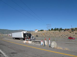
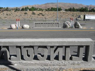
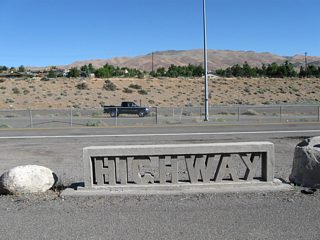
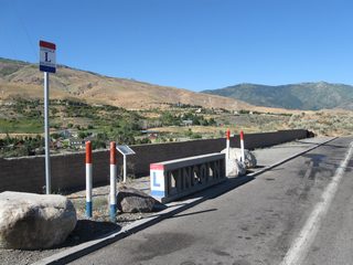
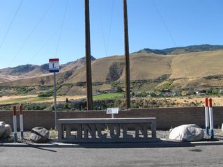
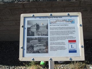
This series of pictures shows some of unique artifacts from the old Lincoln Highway located at the scenic view / truck parking area along Interstate 80 eastbound at milepost 6. These bridge rails were transported from an abandoned section of U.S. 40 (Lincoln Highway) and placed here for public display.
| These are the first Lincoln Highway bridge rails ever built for the transcontinental highway. Photo taken 09/05/10. 09/05/10 |
| The Lincoln Highway bridge rails were salvaged from portions of abandoned U.S. 40 in the early 1970s and placed at the Verdi scenic view area. Photo taken 09/05/10. 09/05/10 |
| Only two sets of Lincoln Highway bridge rails were ever cast. The other set was located in Tama, Iowa. Photo taken 09/05/10. 09/05/10 |
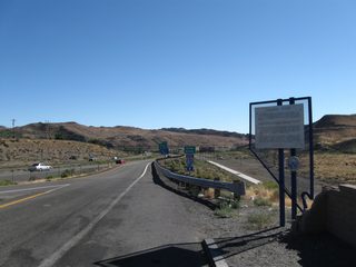
| The Truckee River flows to the immediate south of the scenic view area along I-80 east at Verdi. Photo taken 09/05/10. 09/05/10 |
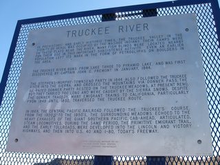
| Nevada historic marker for the Truckee River at the Verdi scenic view area along I-80 east. Photo taken 09/05/10. 09/05/10 |
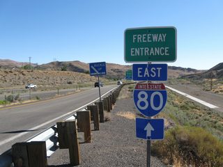
| Freeway entrance shield assembly posted at the return ramp to Interstate 80 east from the Verdi scenic view area. Photo taken 09/05/10. 09/05/10 |
 scenes scenes |
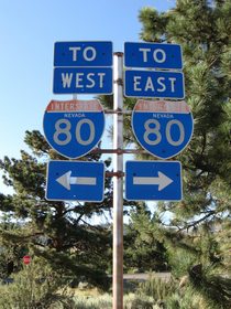
| Trailblazers direct motorists departing Crystal Peak Park along Crystal Peak Road north onto Business Loop I-80/SR 425 (3rd Street) back to I-80 through Verdi. 07/18/09 |
- Lawrence K. Hersh; email, "Interstate Nevada 80, Humboldt Sink," May 13, 2004.
Photo Credits:
07/18/09, 09/05/10 by AARoads
Connect with:
Interstate 580
U.S. 93
U.S. 93 Alternate
U.S. 95
U.S. 95 Alternate
U.S. 395
Page Updated 07-17-2017.


